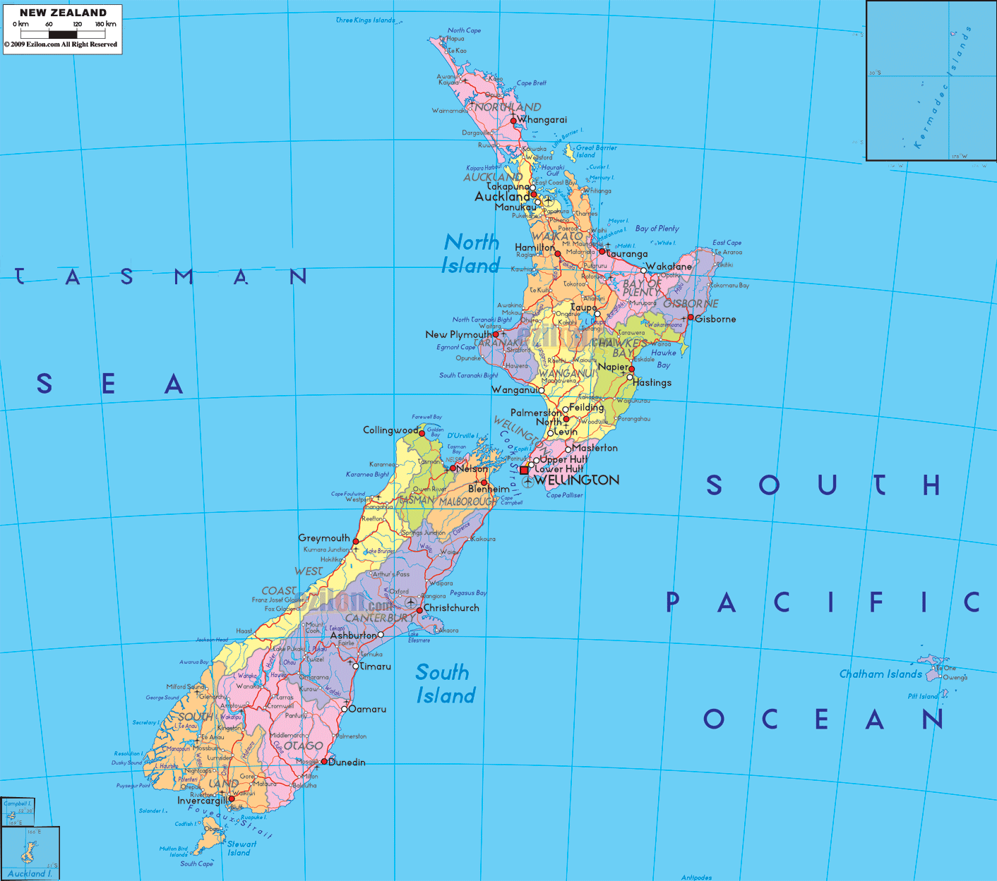
Description: Detailed large political map of New Zealand showing names of capital city, towns, states, provinces and boundaries with neighbouring countries.
Detailed map of New Zealand with cities, towns, regions, villages and surrounding countries. New Zealand's nearest neighbors across the Pacific and Tasman Sea include Australia, Fiji, and Tonga. This is a comprehensive map of the mainland of New Zealand, from the northern tip of the North Island to the southern coast of the South Island and the Chatham Islands offshore, showing each region shaded in color and its main urban areas clearly labeled.
As a map that shows regions, cities, towns, seas, and even some foreign countries, but not the landscape, it is perhaps the best map format for understanding how New Zealand's localities are organized.
The political map of New Zealand is largely characterized by its two main landmasses, the North Island and the South Island. The Tasman Sea lies to the west and the South Pacific Ocean to the east. The map of New Zealand with regions is divided into 16 regional councils and one special territorial authority. Each area is shaded in a different color.
In addition, regional boundaries are clearly marked on the map. Inset in the corners of the map, on either side of the edge, is a small map showing New Zealand's location in the wider Pacific Ocean, and beyond New Zealand are clusters of islands that span the entire map, possibly including the Chatham Islands.
On both the islands, the New Zealand map with cities uses labeled dots and symbols to indicate the locations of large cities, regional towns, and minor settlements. Bolder text and larger symbols indicate the cities of Auckland, Wellington, Christchurch, Hamilton, Tauranga, and Dunedin.
Smaller names denote dozens of provincial towns that service rural areas. These thin lines on the image indicate where the main roads between these locations are found without making it into a travel road atlas.
The New Zealand cities map shows that Wellington is the country's capital, located in the lower North Island. The map shows the city near the southern tip of New Zealand's North Island, facing the Cook Strait. The label is near Lower Hutt, Upper Hutt, and Porirua. As shown on the map, Wellington is centrally located between the North and South Islands. It is a significant political and transport location.
To the north, the New Zealand mapping cities level - Auckland, the largest population center on a narrow isthmus on the upper North Island. The label Auckland is in larger lettering, and the neighboring towns North Shore, Manukau, and Waitakere are shown as adjacent, indicating a larger metropolitan area.
The South Island has Christchurch on the east coast, followed by Hamilton, Tauranga, Dunedin, Palmerston North, Napier, Hastings, Whangārei, New Plymouth, and Invercargill as important cities.
On this New Zealand map, you will see the division of the North Island into numerous regions. Regional councils and main towns are a feature of every region. At the very top, the Northland region occupies the long peninsula reaching towards the subtropics, with its most important center, Whangārei, at the top and smaller coastal towns dotted along the way. As already mentioned, the Auckland Region is centered on Auckland, south of Northland, and includes its far-flung suburban centers.
In the Waikato Region, Hamilton is the largest town, with Cambridge, Huntly, and Tokoroa located on the main inland routes further south. In the east, the Bay of Plenty Region features Tauranga and Whakatāne. At the same time, Gisborne is the only town within the secluded Gisborne Region on the far eastern edge of the North Island. Napier and Hastings are two urban centers on the east coast of the Hawke's Bay Region. The Taranaki on the west, New Plymouth, faces the Tasman Sea.
Located in the southern section of New Zealand's North Island, the Manawatū–Whanganui Region encompasses Palmerston North and Whanganui, whilst the Wellington Region surrounds the capital and its satellite towns. The coloured regional blocks and city labels make it easy for local people and children to see how the North Island is politically administered and which urban center each region uses.
The New Zealand map provides detailed information about the South Island. The South Island, like the North, has been further divided into regions, with towns and villages named on the New Zealand map. At the northern end of the South Island, Northland and Auckland are matched by Tasman, Nelson, and Marlborough, which together occupy the area around the southern shores of the Cook Strait. The small city of Nelson is prominently displayed near Tasman Bay, while Blenheim is shown as the main settlement of the Marlborough wine region.
The narrow strip to the south and west of the Southern Alps along the Tasman Sea includes the West Coast Region, which includes the towns of Westport, Greymouth, and Hokitika, designated as local centers. The eastern side of the island has the Canterbury Region, anchored in Christchurch, with the Towns of Timaru and Ashburton labeled on the coastal plain.
In the southern part of the region, the Otago Region includes Dunedin as its main city, with other towns around it, such as Queenstown, Alexandra, and Oamaru. The Southland Region in the extreme south includes Invercargill and Gore as its main urban centers.
The colored regions and city names on the South Island give visitors a quick way to find out where they are going, e.g., Christchurch to Dunedin or Nelson to Westport. Likewise, these provide students with a structure for memorizing New Zealand's regional layout.
Picture a trip along the map of New Zealand with cities and towns, starting at the top of the North Island and working south. Starting at Cape Reinga and following the Northland peninsula, the towns and villages gradually lead you to the first major city stop of Whangārei. After that, the journey proceeds towards Auckland, whose name is indeed printed at the bottom. Underneath that, many suburban names are printed in the area.
Continuing south on the New Zealand map with cities, road lines take you through Hamilton in the Waikato and then east to Tauranga in the Bay of Plenty or west to New Plymouth in Taranaki. Moving down the island, you pass Rotorua, TaupōTaupō Napier in the center and east, and Palmerston North and Whanganui as you enter the south. At last, your finger arrives at Wilson, where the ferry routes suggested by the map cross over Cook's Strait to the South Island.
New Zealand cities on the map promise not to let you down. On the South Island, a journey that covers the area from Nelson and Blenheim leads north to south through Greymouth or Christchurch, depending on the route, and then south onward to Dunedin and Invercargill. With these chains of cities and towns, the political map becomes a useful tool for planning road trips or for understanding how population corridors run through the two islands.
Despite having no land borders, the map of New Zealand with cities and regions nonetheless provides a significant international context. The nation is situated in the Southern Pacific Ocean, south-east of Australia across the Tasman Sea, and south of the island nations of New Caledonia, Fiji, and Tonga.
The seas surrounding the country are clearly labeled in this map. Moreover, this map also shows the Tasman Sea to the left and the South Pacific Ocean to the right. This gives you an idea of New Zealand's isolated position.
Given that many users looking for a Map of New Zealand cities or a New Zealand map with towns are also planning international trips, the ocean and neighboring context help them visualize air and sea routes between New Zealand and various parts of Oceania. The same labels for Geography students assist discussions about New Zealand's position in the Pacific and its maritime limits.
This political map of New Zealand with towns and villages includes a legend that uses symbol size and text weight to show urban hierarchy across the country. The main cities of New Zealand are Auckland, Wellington, and Christchurch, which is why they are depicted on the map.
Cities like Hamilton, Tauranga, Dunedin, Palmerston North, Napier, Hastings, Whangārei, New Plymouth, and Invercargill serve as medium-sized centers, important regional capitals, or service towns.
In addition to these, many small towns and villages are marked on the map with small texts and dots. However, the markings are still large enough for locals and travelers to use the map to find these little towns and plan detailed trips in New Zealand. For students, the diagram visually shows how New Zealand's population is concentrated in a few large cities, with a network of mid-sized centers and rural towns supporting nearby districts.
By connecting areas such as regions, cities, towns, roads, seas, and international aspects, this New Zealand map with cities and towns serves different purposes. People can see where their regional or district council is based and how nearby towns relate to their nearest major city – whether that is Auckland, Wellington, Christchurch, or another regional center.
Tourists can use marine and road connections to create itineraries linking major cities with smaller centers. For example, someone arriving in New Zealand might drive from Auckland to Rotorua and Taupo, from Christchurch to Taupō, and from Dunedin to Taupo, using the place names on the map to find towns to stop at along the way.
The map of New Zealand with regions is a pocket case study for geography students on how a developed island nation organizes its administrative regions and settlements across the two large islands and the smaller ones.
Because the political is more important than the physical, students can focus on Human Geography issues such as regional councils, city distribution,s and transport corridors before layering other factors, such as temperature or landforms.
New Zealand is located in the South Pacific Ocean southeast of Australia.
The map shows the North Island and the South Island as New Zealand’s two main landmasses.
The political map shows 16 regional councils and one special territorial authority.
Wellington is shown as the national capital at the southern end of the North Island.
Major cities shown include Auckland, Wellington, Christchurch, Hamilton, Tauranga, Dunedin, and Invercargill.
Auckland is located on the upper North Island on a narrow isthmus between two harbors.
Towns and urban centers around Auckland include North Shore, Manukau, and Waitakere.
Wellington is located near Cook Strait at the southern tip of the North Island.
Nearby towns shown include Lower Hutt, Upper Hutt, and Porirua.
Christchurch is located on the eastern coast of the South Island in the Canterbury Region.
North Island regions shown include Northland, Auckland, Waikato, Bay of Plenty, Gisborne, Hawke's Bay, Taranaki, and Wellington.
Northland towns shown include Whangarei and smaller coastal communities along the peninsula.
Hamilton is located in the Waikato Region in the central North Island.
Waikato towns shown include Hamilton, Cambridge, Huntly, and Tokoroa.
The Bay of Plenty Region includes Tauranga and Whakatane.
Gisborne is located on the eastern coast of the North Island.
Cities shown in Hawke's Bay include Napier and Hastings.
New Plymouth is located in the Taranaki Region facing the Tasman Sea.
Main towns shown include Palmerston North and Whanganui.
South Island regions shown include Tasman, Nelson, Marlborough, West Coast, Canterbury, Otago, and Southland.
Nelson is located near Tasman Bay at the northern end of the South Island.
West Coast towns shown include Westport, Greymouth, and Hokitika.
Canterbury towns shown include Christchurch, Timaru, and Ashburton.
Otago cities and towns shown include Dunedin, Queenstown, Alexandra, and Oamaru.
Southland towns shown include Invercargill and Gore.
The map shows the Tasman Sea and the South Pacific Ocean surrounding New Zealand.
Nearby countries shown include Australia, Fiji, Tonga, and New Caledonia.
Yes, the map clearly displays regional council boundaries and settlement patterns.
Yes, the map helps travelers and students understand regions, cities, transport corridors, and population centers.
No. Printing or copying maps from this site is not permitted.

Physical Map of New Zealand
Physical map and map image of New Zealand.

Regional Directory of Australia
Information and guide about Australia and website listing.

Regional Directory of United States of America
Information and guide about United States of America and websites with American topics.

Regional Directory of Europe
Information and guide about Europe and websites with European topics.

Regional Directory of Australia
Information and guide about Australia and websites with Australian topics.