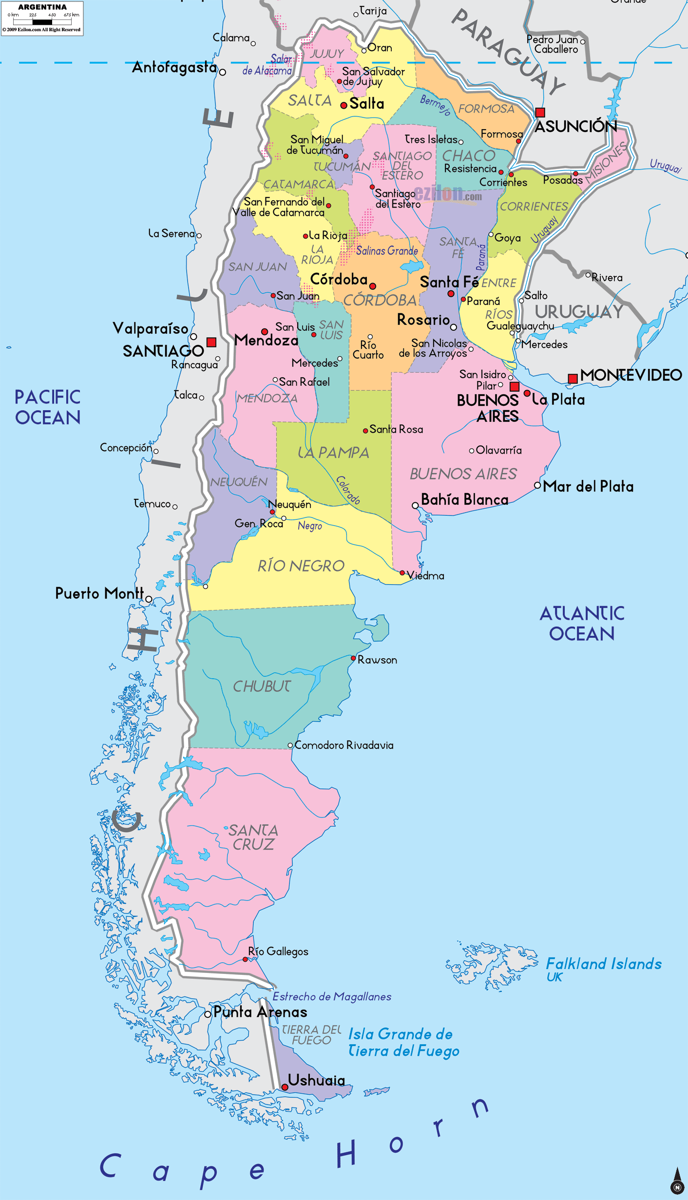
Description: Detailed large political map of Argentina showing names of capital city, towns, states, provinces and boundaries with neighbouring countries.
 Argentina stretches like a tall rectangle along the Andes on the west and the Atlantic Ocean on the east. The country is divided into 23 provinces plus the Autonomous City of Buenos Aires. Red squares mark capitals. Red dots mark major towns. Light red lines trace the main road corridors that connect the provinces.
Official name: Argentine Republic
Capital: Buenos Aires
Largest metro areas: Buenos Aires, Córdoba, Rosario, Mendoza, La Plata
Subdivisions: 23 provinces plus the Autonomous City of Buenos Aires
Neighbors: Chile, Bolivia, Paraguay, Brazil, Uruguay
Coasts: Atlantic Ocean from Buenos Aires to Río Gallegos and beyond
Iconic regions: Pampas grasslands in the center, Andes to the west, Patagonia in the south, Iberá wetlands in the northeast
Air gateways: Ezeiza International (near Buenos Aires) and major airports at Córdoba, Mendoza, Salta, Bariloche, and Ushuaia
Buenos Aires is the national capital. On the map, it sits on the Río de la Plata along the east coast. The surrounding province is also called Buenos Aires, with its own provincial capital, La Plata, located just southeast of the city. From this anchor, you can follow the coast south past Bahía Blanca and Mar del Plata.
Jujuy Capital San Salvador de Jujuy is tucked in the far northwest near the Bolivia border. The province of Jujuy sits between ridges of the Andes and high valleys.
Salta, Located South of Jujuy, has Salta as its capital and towns like San Ramón de la Nueva Orán and Tartagal as its northern outposts, facing Bolivia and Paraguay.
Formosa. On the upper right of the map, the pale green province of Formosa borders Paraguay. The capital, Formosa, sits on the Paraguay River.
Chaco, West of Formosa, is centered on Resistencia near the Paraná River. The label Resistencia helps you track the corridor that runs south toward Corrientes and Santa Fe.
Misiones The wedge-shaped province at the far northeast is Misiones, surrounded by Paraguay and Brazil. The capital, Posadas, faces Encarnación across the river. Towns like Puerto Iguazú sit near the famous falls at the corner where the borders meet.
Corrientes, located just south of Chaco and west of Misiones, has its capital, Corrientes, on the west bank of the Paraná River, with Goya further south along the river bend.
Santiago del Estero, Located South of Chaco, is the capital of the province of Santiago del Estero, situated almost in the center of the northern plains.
Tucumán is A small but significant province west of Santiago del Estero. Its capital, San Miguel de Tucumán, is an easy dot to find at the foot of the mountains.
Catamarca, Southwest of Tucumán, with capital San Fernando del Valle de Catamarca, is labeled as Catamarca on many maps. The terrain climbs rapidly toward the Andes.
La Rioja, South of Catamarca, lists its capital La Rioja and sits between mountain spurs that lead west to Chile.
San Juan, West of San Luis and north of Mendoza, shows capital San Juan near the Andes, marking a classic Andean gateway in the center west.
Córdoba is a large central province with its capital, Córdoba, one of Argentina’s biggest cities. The map also marks Río Cuarto and other towns along the road lattice that links Córdoba to Rosario and Buenos Aires.
Santa Fe, on the Paraná River, has the capital Santa Fe and the central city Rosario to the south. Rosario is a key river port, easy to spot on the west bank of the Paraná.
Entre Ríos is the island-like province between the Paraná and Uruguay rivers. The capital Paraná faces Santa Fe across the water. Gualeguaychú and Concordia line the Uruguay River toward Uruguay.
San Luis, Located West of Córdoba, is the capital of San Luis. It sits on the central north-south corridor that continues to Mendoza.
Mendoza Against the Andes, Mendoza and the city of Mendoza anchor wine country and a major Andean pass to Santiago in Chile. San Rafael appears in the south of the province on the map.
La Pampa, South of Mendoza and Buenos Aires province, spreads across the plains with the capital Santa Rosa in the center west.
Traveling down the coast from Buenos Aires, you meet:
Mar del Plata is in the southeast of the province of Buenos Aires
Bahía Blanca, near the boundary with Río Negro
Viedma in Río Negro, sitting by the river mouth. Continue south into Chubut with Rawson as the capital and Comodoro Rivadavia on the Gulf of San Jorge. Further down, Santa Cruz shows Río Gallegos as its capital, close to the strait that leads to the southern islands.
Neuquén, West of Río Negro, Neuquén has capital Neuquén and General Roca on the provincial edge, marking the start of the northern Patagonia valleys.
Río Negro. The broad yellow band with capital Viedma at the coast and interior towns like General Roca and Bariloche at the Andes edge.
Chubut extends from the Andes to the sea. Rawson is the capital near Trelew, with Comodoro Rivadavia on the south coast.
Santa Cruz is a big southern province with its capital in Río Gallegos. Lakes and ice fields dot the west near the Andes.
The Strait of Magellan splits Tierra del Fuego at the map’s foot. The Argentine sector shows Ushuaia on Isla Grande de Tierra del Fuego, which many maps call the world’s southernmost city.
Chile forms the entire western land border along the Andes.
Bolivia touches Jujuy and Salta in the far north.
Paraguay borders Formosa and Chaco along the Paraguay River.
Brazil meets Misiones at the northeast corner near Iguazú.
Uruguay lies across the Uruguay River and the Río de la Plata from Entre Ríos and Buenos Aires.
The Atlantic Ocean lines the whole east coast. The map also points to the Falkland Islands out in the South Atlantic.
Use the red lines to sketch the central travel spines.
North to Capital Spine Jujuy to Salta to Santiago del Estero to Córdoba to Rosario, then to Buenos Aires. This is the most traveled inland axis.
Andean Corridor Jujuy and Salta south through Catamarca, La Rioja, San Juan, Mendoza, then into Neuquén and Río Negro. This mirrors the famous Ruta 40 chain.
Atlantic Corridor From Buenos Aires south through Bahía Blanca, Viedma, Rawson, Comodoro Rivadavia, Río Gallegos, and finally across to Ushuaia on Tierra del Fuego.
Littoral River Route Formosa to Resistencia, Corrientes, Posadas, Paraná, Santa Fe, and down toward Buenos Aires along the Paraná and Uruguay rivers.
tropical, the southernmost tip in Patagonia sub-antarctic, while the Pampa is mild and humid.

Physical Map of Argentina
Physical map and map image of Argentina.

Regional Directory of South America
Information and guide about South America and website listing.

Regional Directory of United States of America
Information and guide about United States of America and websites with American topics.

Regional Directory of Europe
Information and guide about Europe and websites with European topics.

Regional Directory of Australia
Information and guide about Australia and websites with Australian topics.