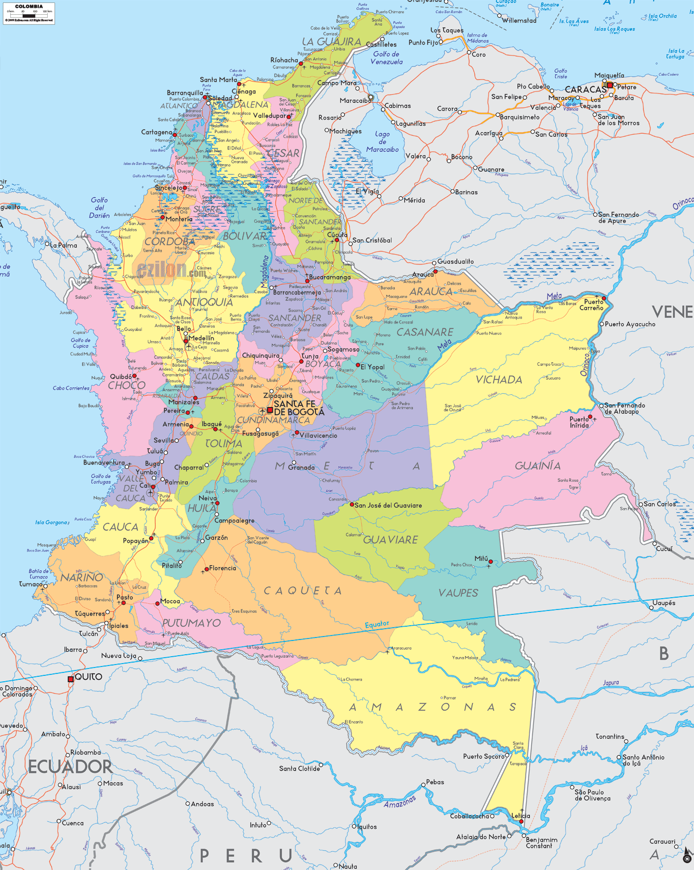
Description: Detailed large political map of Columbia showing names of capital city, towns, states, provinces and boundaries with neighbouring countries.
 Map of Colombia. Colombia map with cities. Major cities, departments, and road networks. Detailed map. Best map. Use this guide like a companion while you look at the map. Every name below matches places you can read on the image, so that you can find cities, departments, borders, and the primary travel corridors fast.
Official name: Republic of Colombia
Capital: Bogotá D. C.
Population: about 52 million
Languages: Spanish is the official language; many indigenous languages are used regionally
Currency: Colombian Peso (COP)
Largest metro areas shown: Bogotá, Medellín, Cali, Barranquilla, Cartagena
Central physical regions: Caribbean coast, Pacific coast, three Andes ranges, Llanos plains, Amazon jungle
Air gateways on the map: Bogotá, Medellín, Cali, Barranquilla, Cartagena, Bucaramanga, Cúcuta, Pereira, Santa Marta, Leticia
Travel spines you can follow: Caribbean coastal highway from Riohacha to Montería and Cartagena; Andean route Medellín–Manizales–Pereira–Armenia–Ibagué–Cali–Popayán–Pasto; Llanos route Bogotá–Villavicencio–Yopal–Arauca.
A red square marks a capital such as Bogotá.
Red dots show major cities and towns.
Thin red lines trace the road-light corridors that link regions.
Blue text marks seas, gulfs, rivers, and international borders.
At the top right of the coast, you will see La Guajira touching Venezuela. The capital, Riohacha, is on the shoreline. The corridor continues southwest to Magdalena, whose capital, Santa Marta, sits below the high Sierra Nevada de Santa Marta.
Next is Atlántico with the big port city of Barranquilla at the mouth of the Magdalena River. Keep following the coastal route into Bolívar, where the map highlights Cartagena de Indias, a famous walled city and department capital.
Southwest of Cartagena, the coast passes Sucre, anchored by Sincelejo a little inland, and then Córdoba with capital Montería on the Sinú River. A feeder corridor turns inland toward Antioquia.
The department of Antioquia is large and central in the northwest. The capital, Medellín, is situated in a valley and is clearly marked. Nearby, you can spot Bello, Itagüí, and Envigado within the metro. Further west, the map shows the Gulf of Urabá coast and road links through Apartadó and Turbo, which connect back to Medellín.
West of Antioquia, Chocó touches both the Caribbean and the Pacific. The capital, Quibdó, appears on the Atrato River. Note how few cross-Andes roads reach the coast here; that is true to the rainforest terrain you see.
East of Antioquia and north of Bogotá lie Santander and Norte de Santander. Bucaramanga is the capital of Santander, with nearby Floridablanca and Girón on the map. Cúcuta is the capital of Norte de Santander, near the Venezuelan line, with border towns shown along the river. Southward lies Boyacá, with its capital, Tunja, and cities such as Duitama and Sogamoso, along a well-marked corridor.
The red square for the national capital, Bogotá, stands out in Cundinamarca. Around it, you will notice Soacha, Facatativá, Zipaquirá, and Chía. Major roads radiate from Bogotá west toward the Magdalena valley, north to Boyacá and the Santanderes, and southeast toward the Llanos.
Southwest of Bogotá, three small departments form the Eje Cafetero or Coffee Axis:
Caldas, with the capital Manizales, is high on a ridge.
Risaralda with the capital Pereira.
Quindío, with its capital, Armenia, is on the road to the Cauca Valley.
Follow the corridor into Valle del Cauca. The capital, Santiago de Cali, is the largest city in the southwest, with the port of Buenaventura on the Pacific. East of Valle lies Tolima, with capital Ibagué, and south of Tolima, you will see Huila with capital Neiva along the Magdalena River.
The next band is Cauca, whose capital, Popayán, sits in the central valley. Farther south, Nariño reaches the border with Ecuador. Its capital, Pasto, is inland, and the Pacific port Tumaco is labeled on the coast. You can trace the road corridor that crosses Ipiales to Ecuador.
East of the Andes, the landscape opens into plains:
Meta, with capital Villavicencio, is the gateway from Bogotá to the plains.
Casanare, with capital Yopal, stretches toward the foothills.
Arauca, with its capital, Arauca, sits on the border river with Venezuela.
Vichada, with capital Puerto Carreño, reaches the Orinoco.
The southeast is mostly rainforest with river towns as anchors:
Guaviare, with San José del Guaviare, lies just beyond Meta.
Vaupés with Mitú appear along river bends.
Guainía, with Puerto Inírida, touches Venezuela and Brazil.
Caquetá, with Florencia, lies south of Huila.
Putumayo with Mocoa borders Ecuador and Peru.
Amazonas, with Leticia, sits at the corner tri-border with Brazil and Peru, marked on the Amazon River.
Caribbean Sea north of Cartagena, Barranquilla, and Santa Marta.
Pacific Ocean along Chocó, Valle del Cauca, Cauca and Nariño.
International borders with Panama to the northwest, Venezuela to the east and northeast, Brazil to the southeast, Peru to the south, and Ecuador to the southwest.

Regional Directory of South America
Information and guide about South America and website listing.

Regional Directory of Caribbean
Information and guide about Caribbean and website listing.

Regional Directory of United States of America
Information and guide about United States of America and websites with American topics.

Regional Directory of Europe
Information and guide about Europe and websites with European topics.

Regional Directory of Australia
Information and guide about Australia and websites with Australian topics.