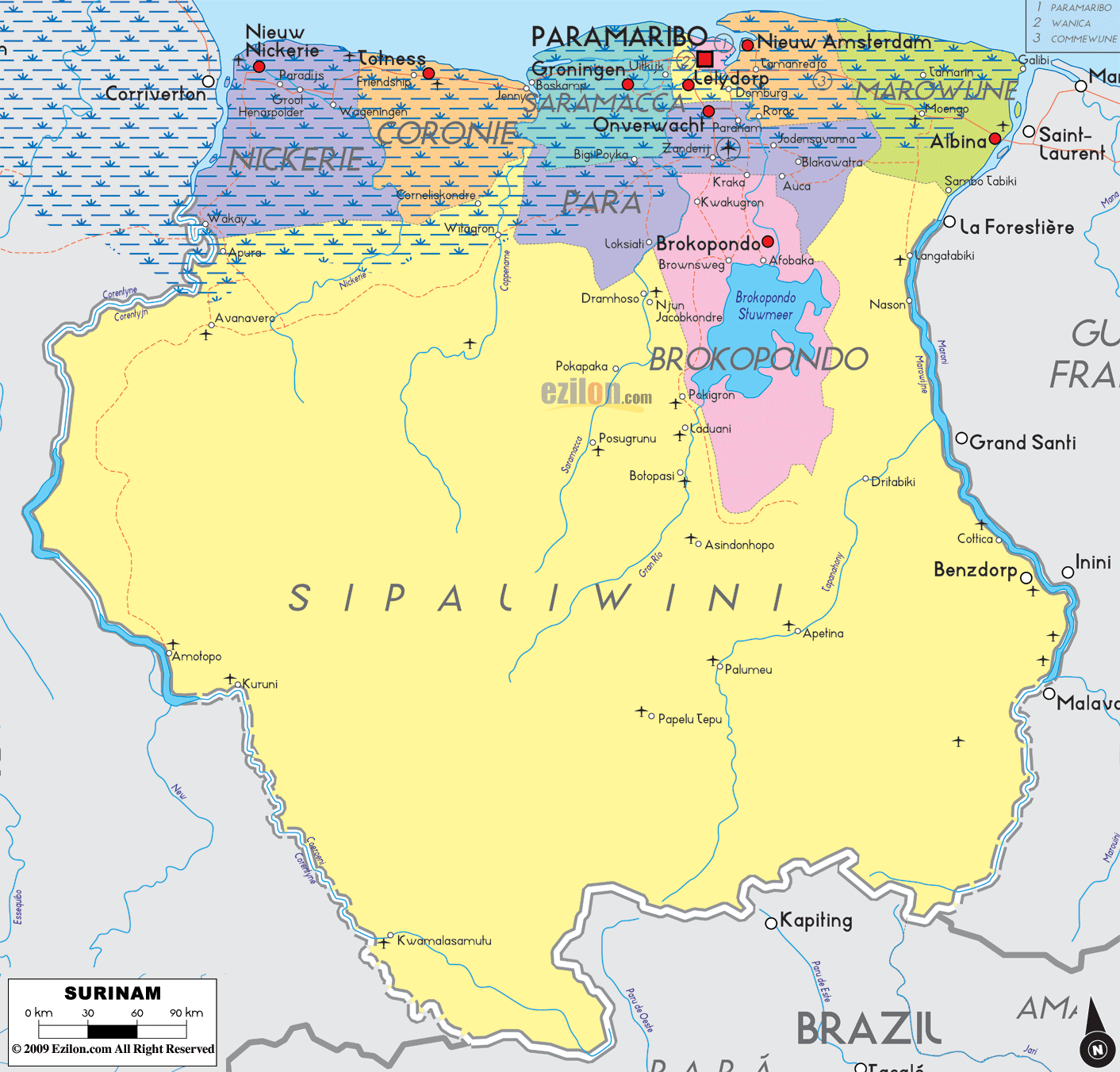
Description: Detailed large political map of Surinam showing names of capital city, towns, states, provinces and boundaries with neighbouring countries.
 Map of Suriname, Suriname map with cities, major cities, provinces, and the road network. Detailed map. Best map. Use this step-by-step guide to read the image like a local. We follow the coast, track the rivers, and head inland so you can quickly find each district, its main towns, the borders with neighboring countries, and the simple road-light corridors that tie everything together.
Official name: Republic of Suriname
Capital: Paramaribo on the lower Suriname River
Districts on this map: Nickerie, Coronie, Saramacca, Paramaribo, Wanica, Commewijne, Marowijne, Para, Brokopondo, Sipaliwini
Borders: Guyana west via the Courantyne, French Guiana east via the Marowijne, Brazil south
Coast: low mangrove shoreline along the Atlantic Ocean
Main rivers shown: Courantyne, Nickerie, Coppename, Saramacca, Suriname, Commewijne, Marowijne, Tapanahony, Lawa.
Key towns to locate: Nieuw Nickerie, Totness, Groningen, Paramaribo, Lelydorp, Nieuw Amsterdam, Moengo, Albina, Onverwacht, Brownsweg, Brokopondo, Apetina, Palumeu, Benzdorp
Air gateway: Johan Adolf Pengel International Airport near Zanderij in Para
Why this map helps: the districts are color-blocked, borders follow rivers, and the road-light lines make it simple to plan coast-to-coast travel or reach the lake and interior villages.
Suriname faces the Atlantic Ocean to the north. The Courantyne River forms the western border with Guyana, the Marowijne River marks the eastern border with French Guiana, and the south meets Brazil across deep forest. A red square marks Paramaribo, the national capital on the lower Suriname River.
Paramaribo district holds the capital Paramaribo, shown by the red square near the river mouth. Look for nearby suburbs labeled around the capital band. On the east bank at the river mouth, you will spot Nieuw Amsterdam in Commewijne.
Wanica sits just south and west of the capital. On the map, you will see Lelydorp and Domburg spread along the urban edge. These places blend into Paramaribo’s metro area and are connected by a short road-light corridor.
Commewijne stretches along the east side of the Suriname River. The coastal road leads from Paramaribo to Nieuw Amsterdam, then out to plantation villages and bridges toward Marowijne.
Marowijne reaches the Marowijne River and the Atlantic. The central coastal town is Albina, opposite Saint-Laurent in French Guiana. Farther inland, you will see Moengo along the interior road. A slim road-light line runs from Paramaribo to Meerzorg, to Moengo, to Albina. This is the classic eastbound corridor.
Para wraps the central lowland south of the capital. The map labels Onverwacht, Kwakoegron and Zanderij. The airfield symbol near Zanderij marks Johan Adolf Pengel International Airport, the main gateway for long-haul flights. A short southbound corridor runs from Paramaribo – Lelydorp – Zanderij – Onverwacht and then bends toward Brokopondo.
Saramacca begins the westward coastal run. You will see Groningen on the Saramacca River, plus villages strung along the straight road facing the mangrove coast and wetlands.
Coronie is a narrow coastal strip with the seat of Totness. The road continues on the same sandy ridge. Tidal flats and coconut groves line this reach, which the map shades with water texture on the ocean side.
Nickerie finishes the coastal chain. The district seat, Nieuw Nickerie, sits near the mouth of the Courantyne River across from Guyana. On the map, you can trace the full East-West Connection from Paramaribo through Saramacca, Coronie, and into Nieuw Nickerie. Rice farms and the Bigi Pan wetlands area lie just inland of the coast here.
Brokopondo lies directly south of Para. The pink district shading surrounds Brokopondo Stuwmeer, also called the Brokopondo Reservoir or Afobaka Lake, which you can clearly see on the map—towns such as Brownsweg, Afobaka, and Brokopondo cluster along the dam road. A neat road-light corridor runs Paramaribo – Zanderij – Afobaka – Brownsweg, then continues by river boat from Atjoni or Pokigron into the upper forest.
Sipaliwini covers most of the country’s interior. It stretches from the Courantyne headwaters in the west to the Lawa and Tapanahony rivers in the east and touches Brazil on the southern line. On the map, you will spot airstrip symbols and small interior villages that act as river gateways:
Apetina on the upper Tapanahony
Palumeu on the Palumeu River
Benzdorp, near the Lawa River, close to the French Guiana line
Kuruni and Arapo near the west interior, and names like Avanavero in the Kabalebo area
Asidonhopo and Drietabbetje clusters along the Upper Suriname and Tapanahony systems
Rivers are your best guide in Sipaliwini. The Gran Rio and Pikin Rio join to form the Suriname River north of the reservoir. The Coppename flows through the central west. The Tapanahony and Lawa join to form the Marowijne on the eastern border.
Guyana lies to the west across the Courantyne River. Look for Nieuw Nickerie near the river mouth and a thin crossing line that hints at ferry service upriver.
French Guiana is to the east across the Marowijne. Albina is the key town on the Suriname side facing Saint-Laurent. Farther inland, the line follows the Lawa River with spots like Benzdorp and French towns Grand Santi and Maripasoula shown across the water.
Brazil borders the south, marked by a gray outline under the forest canopy. Interior posts and airstrips near names like Kwamalasamutu and Kapting act as remote access points.
Large colored names mark districts: Nickerie, Coronie, Saramacca, Paramaribo, Wanica, Commewijne, Marowijne, Para, Brokopondo, Sipaliwini.
Red dots show towns and district seats, and the red square marks Paramaribo.
Blue textures and lines point to coast flats and rivers. Follow the rivers to find interior villages and crossing points.
Thin red lines are road-light corridors. The clearest ones are the East-West Connection along the coast and the Paramaribo – Zanderij – Afobaka – Brownsweg route toward the lake.

Physical Map of Surinam
Physical map and map image of Surinam.

Regional Directory of South America
Information and guide about South America and website listing.

Regional Directory of United States of America
Information and guide about United States of America and websites with American topics.

Regional Directory of Europe
Information and guide about Europe and websites with European topics.

Regional Directory of Australia
Information and guide about Australia and websites with Australian topics.