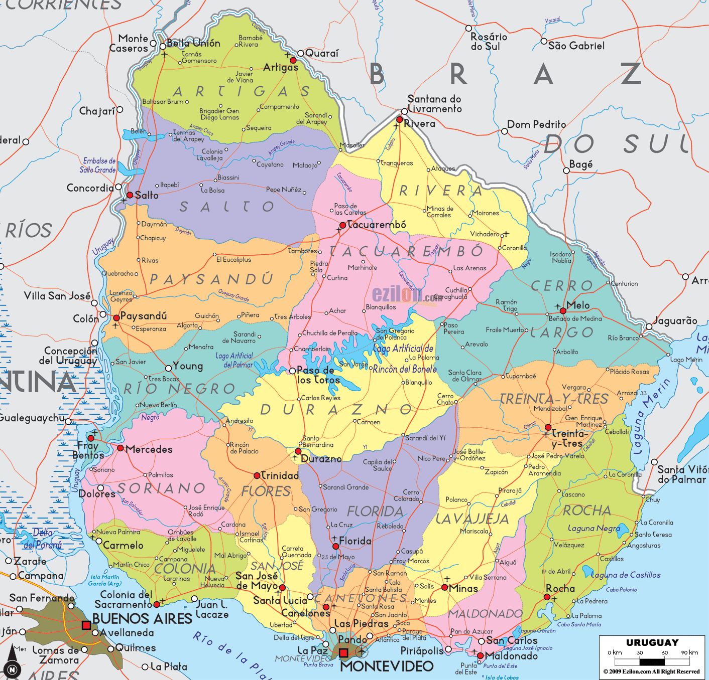
Description: Detailed large political map of Uruguay showing names of capital city, towns, states, provinces and boundaries with neighbouring countries.
 Map of Uruguay, featuring cities, major cities, departments, and a road network. Use this detailed map to see how the country is organized. It shows the 19 departments, each in a different color, with clear labels for the department capitals, well-known towns, the national capital Montevideo, international borders with Argentina and Brazil, coastlines on the Atlantic Ocean and Río de la Plata, and easy-to-follow road-light corridors that link places for travel planning. If you are a student, traveler, or resident, this is the best map style for learning where each city and department is located and how to navigate between them.
Departments are color-coded and named in large type.
A red square marks Montevideo, the national capital on the south coast.
Red dots mark the capitals of departments and other major cities, including Salto, Paysandú, Maldonado, Rivera, Tacuarembó, Durazno, Florida, Rocha, Treinta y Tres, Minas, Mercedes, Colonia del Sacramento, and San José de Mayo.
Thin red lines show the main road-light corridors that connect departments. Use them to follow coast-to-coast and river-to-sea routes.
Overview: Uruguay is a small South American country located between Argentina and Brazil, with coasts on both the Atlantic Ocean and the Río de la Plata. It has 19 departments, Spanish as its official language, and Montevideo as its capital and largest city. The climate is temperate with four seasons, and the landscape is mostly rolling plains crossed by the Río Negro.
Quick facts for travelers and students
Continent: South America
Neighbors: Argentina to the west, Brazil to the north and east
Coasts: Río de la Plata south, Atlantic Ocean southeast
Highest point: Cerro Catedral near Minas in Lavalleja
Time zone: UTC-3
Notable destinations: Montevideo Old City, Colonia del Sacramento, Punta del Este, Cabo Polonio, Rocha coast, Hot springs near Salto
Getting around: national buses link all department capitals; main corridors run river-to-coast and north-to-south through Rivera–Tacuarembó–Durazno–Montevideo.
Starting in the far north, the map shows Uruguay’s border with Brazil. This line runs by rivers and low hills.
The Artigas Department sits in the extreme north. The capital Artigas appears just south of the border near the Cuareim River. A road-light corridor drops south from Artigas toward Salto, linking farms and river ports.
West of Artigas is the Salto Department on the Uruguay River. The city of Salto is a bold red dot facing Concordia in Argentina. Bridges and roads here make Salto a gateway between the two countries.
East of Artigas, the border meets the Rivera Department. The twin cities of Rivera (Uruguay) and Santana do Livramento (Brazil) touch at the line on your map. From Rivera, a clear north-south corridor runs to Tacuarembó.
Southeast of Rivera, the map labels Cerro Largo Department with its capital, Melo. The border town Río Branco is shown near the Brazilian city Jaguarão. A road heads south toward coastal Rocha.
The entire western side of the map follows the Uruguay River, which separates Uruguay from Argentina. This is the north-to-south river route.
Paysandú Department is marked by Paysandú along the river. It is a trade and bridge crossing point. The map shows roads from Paysandú to Young and east toward Guichón.
South of Paysandú, the Río Negro Department has its capital, Fray Bentos, on a large bend of the river. A central corridor continues east toward Young and Tres Bocas and south toward Mercedes.
Soriano Department sits next to Mercedes as its capital, and the port town of Dolores to the west. The road-light line follows the river down to Colonia.
At the southwest tip is the Colonia Department. Colonia del Sacramento appears on the Río de la Plata facing Buenos Aires. To the west, you can spot Carmelo and Nueva Palmira, which are river ports linked by roads to the interior.
The middle of the map is a network of ranching towns and service centers connected by simple road spines.
The Tacuarembó Department is extensive and lightly populated. The city of Tacuarembó sits almost in the center of the country. Corridors from here run north to Rivera, west to Paysandú, and south to Durazno.
The Durazno Department shows Durazno on the Río Yí. It is a key junction for routes heading to Florida, Trinidad, San José, and Montevideo.
The Flores Department lies just west of Durazno. Its capital, Trinidad, is a red dot on the map. Roads here link north to Río Negro and south to Florida and San José.
The Florida Department, with the capital Florida, sits between Durazno and the capital region. A straight corridor runs south to Canelones and Montevideo.
Uruguay’s east combines rolling country with lagoons and beaches.
Treinta y Tres Department has Treinta y Tres as the capital, located near the Olimar River. Roads here split northwest toward Melo and south toward Minas and Rocha.
The Lavalleja Department is centered on Minas. The map shows Minas as an inland hub with corridors to Maldonado, Rocha, Treinta y Tres, and Florida.
The Rocha Department touches the Atlantic. The city of Rocha is inland, while Chuy lies at the Brazilian border on the coast. You can also spot coastal names like La Paloma and Punta del Diablo along the shore.
Maldonado Department is the central beach zone east of Montevideo. Maldonado and Punta del Este sit on a point that separates the Río de la Plata from the open Atlantic. A bold road-light corridor ties Maldonado back to Canelones and Montevideo.
The south coast is the most urban part of the map.
The Montevideo Department holds the national capital of Montevideo, which is marked by a red square. You can see the port setting on the wide Río de la Plata.
Canelones Department wraps around Montevideo. Towns such as Las Piedras, Pando, Atlántida, Santa Lucía, and Canelones are labeled. The main airport sits east of Montevideo near Ciudad de la Costa.
The San José Department lies to the west, with San José de Mayo inside and Ciudad del Plata near the river. Roads link San José with Colonia, Florida, and back to Montevideo.
Follow the Uruguay River south, and you will pass a chain of cities used by travelers and trucks.
Artigas to Salto: this north segment crosses orange groves and ranches. You can see Bella Unión at the triple point near the Argentine and Brazilian borders.
Salto to Paysandú: the map shows a flat ribbon of road reaching Guichón and then the riverfront at Paysandú.
Paysandú to Fray Bentos: the route continues past Young, then to the Río Negro bridge area.
Fray Bentos to Mercedes and Dolores: the corridor keeps close to the water.
Mercedes to Colonia del Sacramento: it ends in the colonial city facing Buenos Aires, with short side trips to Nueva Palmira and Carmelo.
A classic inland drive runs from the Brazilian line down to Montevideo.
Start at Rivera. The map places the city exactly on the border.
Continue to Tacuarembó, which is marked at the center of the department.
Head to Durazno on the Río Yí, then Florida, and finally into Montevideo. This route crosses cattle country and serves as the most direct interior link to the capital.
The East Coast is long and scenic.
From Melo in Cerro Largo, the road drops to Treinta y Tres and the Olimar River.
The corridor then cuts to Rocha and the sea. The map shows Chuy at the Brazil border on the coast.
Turn west to Maldonado and Punta del Este, then continue to Piriápolis and Atlántida in Canelones before reaching Montevideo.
Artigas — capital Artigas; see Bella Unión on the river point.
Salto — capital Salto; towns Daymán, San Antonio.
Paysandú — capital Paysandú; Guichón, Quebracho, Young.
Río Negro — capital Fray Bentos; Young, San Javier.
Soriano — capital Mercedes; Dolores, Cardona, José Enrique Rodó.
Colonia — capital Colonia del Sacramento; Carmelo, Nueva Palmira, Juan Lacaze.
San José — capital San José de Mayo; Ciudad del Plata.
Canelones — capital Canelones; Las Piedras, Pando, Atlántida, Ciudad de la Costa.
Montevideo — national capital Montevideo on the Río de la Plata.
Maldonado — capital Maldonado; Punta del Este, Piriápolis, San Carlos.
Rocha — capital Rocha; Chuy, La Paloma, Castillos.
Lavalleja — capital Minas.
Treinta y Tres — capital Treinta y Tres.
Florida — capital of Florida; Sarandí Grande.
Flores — capital Trinidad.
Durazno — capital of Durazno.
Tacuarembó — capital Tacuarembó; Paso de los Toros appears just across in Durazno, but is connected by bridge to the north.
Rivera — capital of Rivera on the line with Brazil.
Cerro Largo — capital Melo; Río Branco at the border with Brazil.
Argentina borders Uruguay along the Uruguay River from Artigas down to Colonia.
Brazil borders Uruguay along the north and east, meeting at towns such as Rivera, Río Branco, and Chuy.
The Río de la Plata and the Atlantic Ocean form the long southern and southeastern coast. Look for names like Punta del Este, José Ignacio, La Paloma, and Chuy along the shore.
The Río Negro runs west to east across the center, feeding into the Uruguay River near Fray Bentos.
For a quick river-to-capital route, follow the west corridor from Colonia or San José to Montevideo.
For beaches, use the south coast line from Montevideo through Canelones and Maldonado to Rocha.
For border crossings, note Rivera and Chuy for Brazil and bridges near Salto, Paysandú, and Fray Bentos for Argentina.
For classroom use, trace each department, then point out its capital and one road-light corridor that links it to Montevideo.

Physical Map of Uruguay
Physical map and map image of Uruguay.

Regional Directory of South America
Information and guide about South America and website listing.

Regional Directory of United States of America
Information and guide about United States of America and websites with American topics.

Regional Directory of Europe
Information and guide about Europe and websites with European topics.

Regional Directory of Australia
Information and guide about Australia and websites with Australian topics.