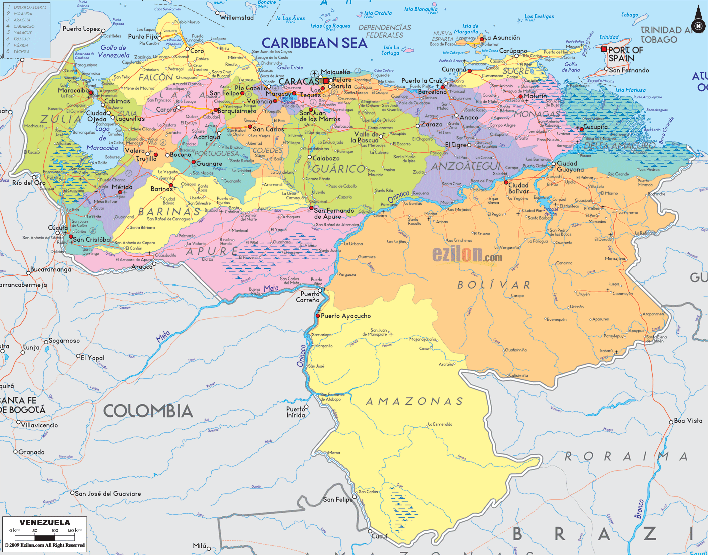
Description: Detailed large political map of Venezuela showing names of capital city, towns, states, provinces and boundaries with neighbouring countries.
 Map of Venezuela, featuring cities, major cities, states, and a road network. This detailed map shows every state in a different color, the national capital Caracas, department capitals, well-known towns, the Caribbean Sea islands, and simple road-light corridors that help you trace trips from coast to jungle. Use it as the best map style for fast orientation, school projects, or planning travel.
Location and neighbors: Northern South America, facing the Caribbean Sea. Borders Colombia, Brazil, and Guyana. Capital and largest metro: Caracas in the Capital District near the Caribbean coast. First look: 23 states plus the Capital District and Federal Dependencies. Spanish is the official language. Regions:
Andes in the west with Mérida and Trujillo.
Llanos plains in the center with Apure, Barinas, Guárico, and Portuguesa.
The Guayana Shield in the southeast, where Bolívar and Amazonas hold tepuis and waterfalls.
Caribbean coast with ports and beach towns from Falcón to Sucre. Key rivers and water bodies: Orinoco, Apure, Caroní, Lake Maracaibo. Notable places on the map: Maracaibo, Valencia, Maracay, Barquisimeto, Maturín, Ciudad Bolívar, Ciudad Guayana, Puerto Ayacucho, Cumaná, Puerto La Cruz, Porlamar on Margarita. Getting around: Inter-state highways link the capital belt with the llanos and the Guayana region. Ferries and flights serve the islands.
The top left of the map is Zulia State, wrapped around Lake Maracaibo. The city of Maracaibo is a large red dot on the west side of the lake, opposite Cabimas, Ciudad Ojeda, and Lagunillas on the east shore. Follow the coastal labels to Los Puertos de Altagracia and San Carlos in the lake area. Roads ring the lake, then swing south toward Santa Bárbara del Zulia and on to the plains.
South of Zulia, the Andes enter Venezuela. Táchira shows San Cristóbal near the Colombian line with a corridor that climbs toward La Fría. Northeast of there, Mérida State is marked by the university city Mérida and the peak zone of the Sierra Nevada. Next over is Trujillo, with Trujillo and Valera placed on the mountain slopes that face Lago de Maracaibo.
Moving east along the coast, the map shows Falcón State with Coro as capital and the peninsula to Punto Fijo. Beaches and dunes line this shore. South of the coast, the inland road reaches Carora on the way to Barquisimeto, the capital of Lara State. Lara’s neighbors, Yaracuy and Cojedes, are smaller states that connect the Andes to the central valleys. You will spot San Felipe in Yaracuy and San Carlos in Cojedes.
The coast bends southeast at Carabobo State, where Valencia sits just inland, with Puerto Cabello on the shore. East of that is Aragua State with Maracay near Lago de Valencia and the coastal town Ocumare de la Costa on the Caribbean side. The map labels Miranda State to the east with Los Teques, Guarenas, and Guatire, plus beach towns toward Higuerote. Right where the mountains touch the sea is the Capital District and Caracas, marked clearly by name and the surrounding corridor. On the immediate coast, you will see La Guaira (often labeled Vargas), which holds the main port and airport area for the capital.
Continue east along the Caribbean. Carúpano and Cumaná appear in Sucre State. Offshore, the Nueva Esparta State islands show Isla de Margarita with La Asunción and Porlamar, plus Coche and Cubagua nearby. South and west of the islands is Anzoátegui State, where twin cities Puerto La Cruz and Barcelona sit on the coast. Inland towns such as El Tigre and Anaco are easy to track along the road-light network that points toward the llanos.
East of Anzoátegui lies Monagas State with Maturín as the capital. The map then opens into Delta Amacuro State, showing the vast Orinoco Delta as it meets the Atlantic. Tucupita is the capital, and channels lace the green marsh area to the ocean.
The middle of the country is the broad llanos or grassland plains. North to south, you will find:
Portuguesa State, with twin cities Acarigua and Araure, plus Guanare as the capital.
Barinas State, with Barinas, lies along routes that rise to the Andes and drop to the plains.
Guárico State covers a massive block from mountains to plains, with San Juan de los Morros and Valle de la Pascua labeled.
Apure State touches Colombia and is crossed by the Apure River. The capital, San Fernando de Apure, sits near the river crossing.
All of southern and southeastern Venezuela is colored for two vast states.
Bolívar State covers the Orinoco south bank and the Guayana Shield. The map shows Ciudad Bolívar on a bend of the Orinoco and Ciudad Guayana on the Caroní River. Other towns, such as Upata, Tumeremo, El Callao, and Caicara del Orinoco, also trace mining and river routes. Farther south, the land rises to the Gran Sabana, with roads pushing toward Santa Elena de Uairén at the Brazil line.
Amazonas State fills the far south with green interior. You will see Puerto Ayacucho on the Orinoco near Colombia and Brazil, plus remote posts such as San Fernando de Atabapo and San Carlos de Río Negro.
Colombia borders the west and southwest, meeting Venezuela near Maracaibo, San Cristóbal, and down the Meta and Orinoco areas.
Brazil borders the deep south across Roraima and Amazonas.
Guyana is to the east.
The Caribbean Sea lines the entire north coast, and across the water, you see Trinidad and Tobago near Sucre and Delta Amacuro.
The Orinoco River curves from the Colombian line past Ciudad Bolívar and Ciudad Guayana, then spreads into the Orinoco Delta.
The Caroní River flows north to meet the Orinoco at Ciudad Guayana.
The Apure River crosses Apure State, meeting the Orinoco near Ciudad Bolívar.
Lake Maracaibo is a major inland sea with channels to the Caribbean.
Use the thin red lines to plan simple routes:
West coastal arc: Maracaibo to Coro to Puerto Cabello to La Guaira to Barcelona and Puerto La Cruz, then east to Cumaná and Carúpano.
Andean chain: San Cristóbal to Mérida to Trujillo, then east to Barquisimeto and San Felipe.
Capital belt: Valencia to Maracay to Caracas with links to Los Teques, Guarenas, and Guatire.
Llanos diagonal: San Cristóbal or Barinas across Acarigua, Guanare, San Carlos, San Juan de los Morros, then Valle de la Pascua and Maturín.
Guayana axis: Caracas or Maracay down to Ciudad Bolívar, across to Ciudad Guayana, then south toward Tumeremo, El Dorado, and Santa Elena de Uairén near Brazil.
Amazonas access: from Ciudad Bolívar upstream along the Orinoco to Puerto Ayacucho.
To match labels quickly, pair each state with its capital or key city you can see on the map: Zulia – Maracaibo, Táchira – San Cristóbal, Mérida – Mérida, Trujillo – Trujillo, Falcón – Coro, Lara – Barquisimeto, Yaracuy – San Felipe, Cojedes – San Carlos, Portuguesa – Guanare, Barinas – Barinas, Carabobo – Valencia, Aragua – Maracay, Miranda – Los Teques, La Guaira – La Guaira, Capital District – Caracas, Guárico – San Juan de los Morros, Anzoátegui – Barcelona, Sucre – Cumaná, Nueva Esparta – La Asunción, Monagas – Maturín, Delta Amacuro – Tucupita, Bolívar – Ciudad Bolívar, Amazonas – Puerto Ayacucho.
The north Caribbean has many small islands grouped as Federal Dependencies. The state of Nueva Esparta includes Margarita, Coche, and Cubagua. Ferries and flights link these islands to Puerto La Cruz and La Guaira.
For a coast tour, trace Coro, Puerto Cabello, La Guaira, Higuerote, Puerto La Cruz, Cumaná, Carúpano.
For mountains, follow San Cristóbal, Mérida, Valera, Trujillo, Barquisimeto.
For rivers and rainforest, follow the Orinoco from Puerto Ayacucho to Ciudad Bolívar to the Delta.
For big city connections, the triangle Caracas – Valencia – Maracay is the most urban area on the map.

Physical Map of Venezuela
Physical map and map image of Venezuela.

Regional Directory of South America
Information and guide about South America and website listing.

Regional Directory of United States of America
Information and guide about United States of America and websites with American topics.

Regional Directory of Europe
Information and guide about Europe and websites with European topics.

Regional Directory of Australia
Information and guide about Australia and websites with Australian topics.