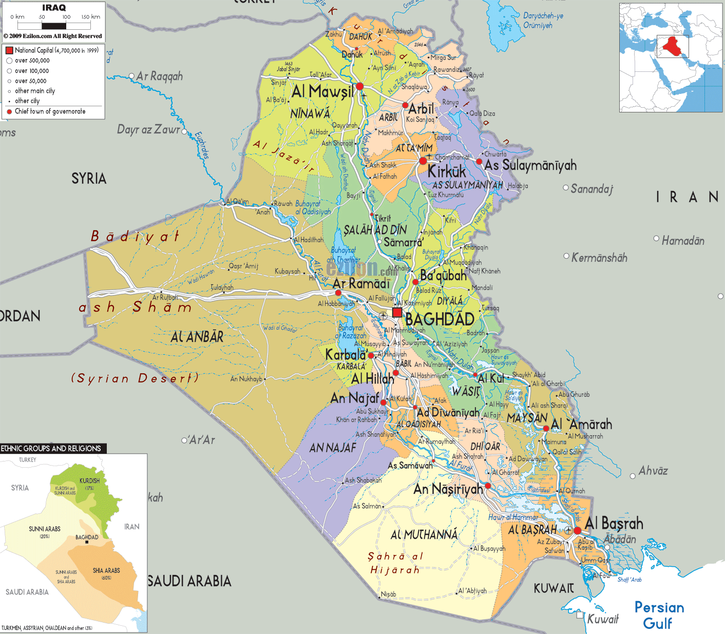
Description: Detailed large political map of Iraq showing names of capital city, towns, states, provinces and boundaries with neighbouring countries.

The Map of Iraq with cities, major cities, and towns provides a highly detailed map of a country shaped by rivers, deserts, and ancient civilizations. As you follow the map visually, Iraq reveals a natural structure that flows from the mountainous north, through fertile plains, and into the southern wetlands near the Persian Gulf. This best map of Iraq is designed to help you understand not only where cities are located, but how provinces, rivers, and transportation routes connect across the entire country.
The map of Iraq shows that the country is divided into 18 governorates. This includes important regions such as Baghdad, Basra, Nineveh, Anbar, and the provinces of the Kurdistan Region. The map highlights major cities, capital centres, and important connections and linkages. It can help travellers, residents of the area, and geography students.
The Tigris and Euphrates rivers run north to south through Iraq. This is something that one notices first of all in the country's layout. These rivers have shaped the geography of Iraq's settlements.
The map shows Iraq positioned in the heart of the Middle East, connecting multiple regions. This border will definitely make you understand the country's relations with its neighbours.
To the north of Iraq is Turkey.
It has Iran to its east.
To the west, it borders Syria and Jordan.
To the south, Saudi Arabia and Kuwait fell.
The south-easternmost corner touches the Persian Gulf, giving the state a little but important access to the sea.
This positioning has made Iraq historically important as a crossroads of trade and culture, linking the Arabian Peninsula, Anatolia, and Persia.
At the top of the map, northern Iraq is dominated by mountainous terrain. The Kurdistan Region comprises the provinces of Dahuk, Erbil, and Sulaymaniyah. It is unique because of its high elevation, but also because it is not primarily Arab or Turkish in its geographic identity.
Cities like Erbil (Arbil) and Sulaymaniyah are clearly marked as big cities. Erbil especially serves as a regional capital and is centrally located in the north.
The two cities whose roads traverse valleys and mountain passes are represented on the map, which shows the important physical configuration of the roadways.
Moving slightly southwest, the map highlights Nineveh Province, with its major city Mosul (Al Mawsil). Mosul is positioned along the Tigris River, which explains its historical importance as a trade and cultural center.
Compared to Kurdistan, the surrounding area appears less rocky and more open and flat. The map shows the clear shift in geography.
At the heart of the map lies Baghdad, the capital of Iraq. Marked prominently, Baghdad sits along the Tigris River, making it one of the most strategically located cities in the country.
According to the map, multiple roads lead to Baghdad. This indicates that it is the political, economic, and transportation center of Iraq.
"Nearby areas, such as Baqubah and Fallujah, are clearly visible and form part of Baghdad."
North of Baghdad, the map shows Salah ad Din Province, including cities such as Tikrit and Samarra. Settlements along the Tigris River demonstrate that waterways shape cities and city life.
To the west, the map opens onto the vast expanse of Al Anbar, Iraq's largest governorate. This region is dominated by the Syrian Desert, which is clearly labeled.
Cities like Ramadi and Fallujah are commonly located along main routes, revealing how settlements concentrate along transport routes and water sources.
This map shows that the area is much less densely populated than the inhabited river valleys of central Iraq.
Moving east from Baghdad, the map shows Diyala Province, with its capital, Baqubah, and further south, Wasit Province.
These areas are located near the border with Iran and are influenced by both river systems and cross-border connections.
At the southern end of the map, Basra (Al Basrah) stands out as Iraq's main port city. Located near the Shatt al-Arab waterway, Basra connects Iraq to the Persian Gulf.
The map clearly shows how waterways dominate this region, with rivers branching out into marshlands.
Nearby provinces such as Dhi Qar (Nasiriyah) and Maysan (Amarah) appear along river channels. These areas are known for the Mesopotamian Marshes, one of the most unique ecosystems in the region.
As you continue to follow the map of Iraq, with cities, major cities, and a road network, the country's structure becomes even clearer when viewed through its governorates. Iraq is divided into 18 administrative subdivisions, each with a designated capital city, economic significance, and a distinct geographical character. The Piece of writing shows that the governorates are not random but reflect the natural patterns of rivers, deserts, mountains, and trade routes in Iraq.
When studying the map closely, you will notice how population density follows the Tigris and Euphrates river systems, while vast open spaces dominate the western and southern desert regions. This balance between fertile river valleys and arid land is one of the defining features of Iraq's landscape.
The map of Iraq shows that Dahuk is at the far north of the country (17 words). The region borders Turkey and has mountainous areas. Dahuk is less populated than other cities in Iraq, but the location makes it a first-class strategic city.
On the map, you can see how road connections extend from Dahuk toward Erbil and Mosul, showing its role as a regional connector. The cities here are smaller and more dispersed than in central Iraq, as the terrain limits expansion.
The map shows that the city of Erbil is located slightly southeast in northern Iraq. Erbil appears prominently, indicating it is the capital of the Kurdistan Region.
The roadmap shows how the connections to Mosul, Kirkuk, and Sulaymaniyah form a triangle on the map. As a result of this connectivity, the city has become a business, governmental, and transport center of the region.
Compared to desert regions, the climate, location on trade routes, and the greater Erbil region's relative socio-political stability have enabled it to achieve a higher level of physical development.
Further east, the map shows Sulaymaniyah, located near the border with Iran. This region appears more rugged, with terrain that becomes increasingly mountainous.
Sulaymaniyah is marked as a major city, and its position on the map highlights its importance in connecting Iraq to eastern trade routes. The map with cities and road network shows connections extending into Iran, emphasizing cross-border interaction.
Moving westward and slightly south, the map clearly marks Nineveh Province, with its major city Mosul (Al Mawsil). Mosul sits along the Tigris River, and this placement is critical.
The map shows how the river flows through the city, providing water, transportation, and agricultural support. This explains why Mosul has historically been one of the most important cities in Iraq.
The surrounding region transitions from mountainous terrain to flatter plains, allowing for more widespread settlement.
Further southeast, Kirkuk appears as another key city. Kirkuk's location on the map between Northern and Central Iraq indicates its role as a connecting point.
Kirkuk is an energy resource, and the shown road connections map is an economically important characteristic of the above area. The routes to Erbil, Baghdad, and Sulaymaniyah make it a transport hub.
The Iraq map with cities highlights Baghdad right at its center. It's hard not to miss! Baghdad, the capital of Iraq, is located on the Tigris River, which runs through it.
The map shows Baghdad as Iraq's most connected location. Roads head in all directions:
North toward Mosul and Tikrit
South toward Babylon and Basra
West toward Anbar
East toward Diyala and Iran
This strategic positioning is also why Baghdad is the political, economic, and cultural centre of Iraq.
North of Baghdad, the map highlights Salah ad Din, including Tikrit and Samarra. These cities are aligned along the Tigris River, forming a continuous corridor of settlement.
This region is less densely populated than Baghdad but still highly important due to its strategic location between northern and southern Iraq.
To the east of Baghdad, the map shows Diyala Province, with its capital, Baqubah. This area lies close to the Iranian border, making it an important gateway for trade and movement.
The map's road-light network shows clear connections from Baghdad into Diyala, illustrating how people and goods move between these regions.
As you shift your attention to the western side of the map, you encounter Al Anbar, the largest governorate in Iraq. This region dominates a huge portion of the country and is clearly labeled as part of the Syrian Desert.
Unlike central Iraq, Anbar has very few large cities. The main urban centers, such as Ramadi and Fallujah, are located along major routes and water sources.
The map shows long stretches of open land, emphasizing how sparsely populated this region is. Geography greatly influences settlement patterns in Iraq, as this case shows.
If you go south from Baghdad, you will find Babylon (Hillah) and Karbala, as shown on the map. Many cities near the Euphrates River were surrounded by fertile land.
The map shows many roadways in the region, suggesting a dense population, and there is also significant movement between the two cities.
The map shows dense road connections in this area, reflecting high population levels and frequent movement between cities.
Further south, Najaf appears as another major city. Due to its location near the desert edge, the area is a transitional zone between fertile river plains and the more arid areas beyond.
Diwaniyah (Qadisiyyah) is marked nearby as well, as cities were connected by road and river systems throughout history.
Continuing south, the map highlights Nasiriyah, located in Dhi Qar Province. This area is deeply connected to the river system, with branches of water visible throughout the region.
The presence of water supports agriculture and settlement, even as the surrounding areas become increasingly arid.
To the southeast, Maysan Province appears with its capital, Amarah. This region is part of the Mesopotamian Marshes, one of the most unique landscapes in Iraq.
The map shows water channels and wetlands, distinguishing this region from both the desert west and the urban center of Baghdad.
At the bottom of the map, Basra stands out as Iraq's southernmost major city. Located along the Shatt al-Arab, Basra connects directly to the Persian Gulf.
The map clearly shows how waterways converge in this region, making it one of Iraq's most important economic areas. This is where maritime trade takes place, linking Iraq to global markets.
To the southwest of Basra, the map shows Muthanna Province, a largely desert region. The capital, Samawah, appears smaller compared to other major cities.
This area is sparsely populated, and the map reflects this with fewer roads and settlements.
To fully understand this detailed map of Iraq with cities and roads network, follow a structured approach:
Take a look at the mountains and Kurdish cities like Erbil and Sulaymaniyah.
Focus on Baghdad and the surrounding provinces where population density is highest.
Notice the vast desert of Anbar and the limited urban development.
Track how cities align along the Tigris and Euphrates toward Basra.
Understand how Basra connects Iraq to international trade routes.
This map of Iraq with cities and major cities is valuable because it allows:
Travelers need to understand distances and routes
Students to study geography and settlement patterns
Researchers will analyze the regional distribution
Residents to visualize connections between cities
The road-light network maintains the map's cleanliness while showcasing important connections, keeping the interpretation simple and clear.
The map shows governorates, cities, rivers, borders, and a simplified road network.
Baghdad is in central Iraq along the Tigris River.
Baghdad.
Mosul is in northern Iraq.
Basra is in southern Iraq near the Persian Gulf.
The Tigris and Euphrates rivers.
Turkey, Iran, Syria, Jordan, Saudi Arabia, Kuwait.
A northern region including Erbil, Dahuk, and Sulaymaniyah.
In northern Iraq.
In north-central Iraq.
A large desert region in western Iraq.
West of Baghdad in Anbar Province.
South of Baghdad.
Southwest of Baghdad.
In southern Iraq.
In southeastern Iraq.
At the southeastern edge near Basra.
Wetlands in southern Iraq.
Western deserts and southern regions.
No. Printing or copying maps is not permitted.

Physical Map of Iraq
Physical map and map image of Iraq.

Road Map of Iraq
Road map and map image of Iraq.

Regional Directory of United States of America
Information and guide about United States of America and websites with American topics.

Regional Directory of Europe
Information and guide about Europe and websites with European topics.

Regional Directory of Australia
Information and guide about Australia and websites with Australian topics.