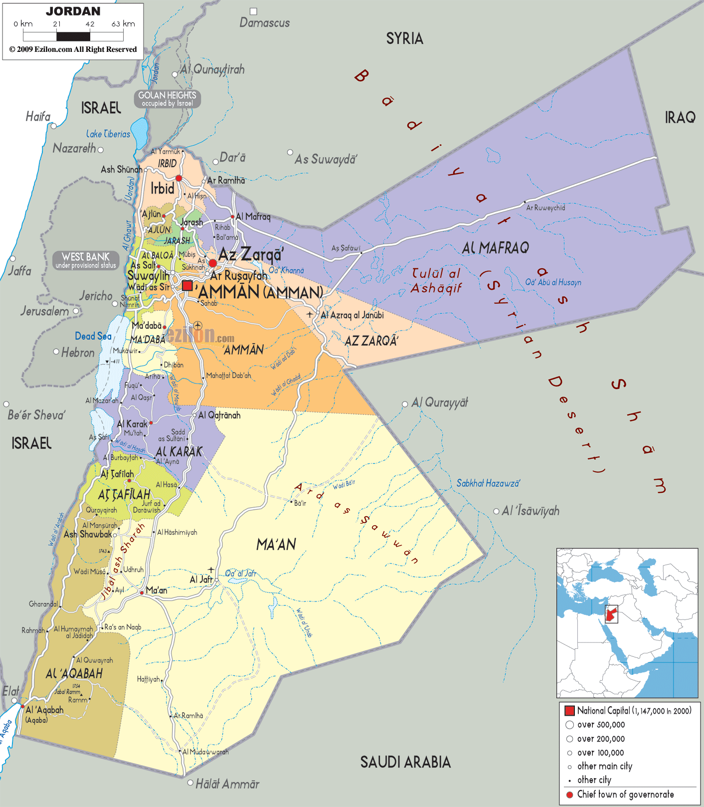
Description: Detailed large political map of Jordan showing names of capital city, towns, states, provinces and boundaries with neighbouring countries.

The Map of Jordan with cities, capital, and governorates is a highly detailed map that captures Jordan's full geographic identity, from the densely populated northern highlands to the vast desert expanses in the south and east. As you look at the map, Jordan appears to be organized, with cities, governorates, and natural features reflecting the geography and settlement patterns.
The Jordan map with cities shows other cities, towns, and administrative divisions like Irbid Governorate, Ajloun, Jerash, Mafraq, Amman, Zarqa, Madaba, Karak, Tafila, Ma'an, and Aqaba. Above all, the capital city of Jordan is Amman. Each of these regions is color-coded, making it easy to distinguish between densely populated areas and sparsely populated desert zones.
The road network in Jordan, although simplified, provides a clear understanding of how major cities connect across the country. This road-light structure is especially useful for travelers and geography students who want to understand how movement flows from north to south and from central hubs to remote regions.
The map clearly shows Jordan positioned in a strategically important part of the Middle East. Due to its geographical shape, it was able to connect countries and logic.
To the north, Jordan borders Syria, with cities like Irbid positioned close to this boundary
To the northeast and east, the map shows Iraq, connected through desert routes
To the south and southeast, Jordan borders Saudi Arabia, with long desert frontiers
To the west, the map highlights Israel and the West Bank, separated by the Jordan Valley and the Dead Sea
The Dead Sea, clearly visible on the western edge of the map, serves as one of the most recognizable natural features. It is the lowest point on Earth and plays a major role in defining Jordan's western boundary.
This positioning makes Jordan an essential part of regional geography, which is reflected in how cities and roads are arranged on the map.
At the top of the map, Irbid stands out as one of the most important cities in northern Jordan. It acts like a pivot in a web of cities that creates the northern population zone.
Irbid is shown on the map alongside the two neighbouring cities, Ar Ramtha and Ajloun. Consequently, cities are in close touch with one another. The region's relatively fertile soil and moderate elevation have enhanced agricultural development.
In the north of the map, smaller distances in the areas are marked on the cities than in the desert area in the south.
Ajloun and Jerash are located in hilly areas slightly south of the map. These regions are famous for their many forests, valleys, and monuments.
The Jordan map with governorates shows how these areas are directly linked to Amman by clear routes, making them part of the corridor in the northern central area.
Cities and roads are located in the direction of higher ground. The movement will occur along valleys and slopes rather than linear pathways.
At the center of the map, Amman (Al' Ammān) is clearly marked as the capital city. Its location is not only central geographically but also central in terms of infrastructure and population.
The map shows Amman as the main hub from which roads extend in all directions:
Northward to Irbid and Ajloun
Eastward to Zarqa and Mafraq
Southward to Karak and Ma'an
Westward toward the Dead Sea and Jordan Valley
Amman's location at the very heart of Jordan makes it the most interconnected city in the country, as it is the country's transport, business, and government centre.
Just northeast of Amman, Zarqa is a major industrial city. Amman and Irbid have merged, and to any observer, it is so evident.
The map of Jordan cities shows how Zarqa's industry and infrastructure help the capital. Its location along major highways underscores its national importance.
To the southwest of Amman, Madaba appears as a smaller but important city located near the western highlands. This area serves as a transition zone between central Jordan and the Jordan Valley.
The map shows how roads from Amman extend toward Madaba and further toward the Dead Sea, highlighting this route as an important travel corridor.
East on the map, the landscape opens out considerably. Mafraq Governorate is dominant in this desert area.
This map is drawn so that fewer cities are shown, and those that are are also spaced farther apart. Mafraq's proximity to the borders of Syria and Iraq makes it strategically important.
The Jordan desert map features clearly show how this region differs from the more populated north and center.
As you head south of Amman, the map shows Karak and Tafila, situated on hilly terrain that marks the transition between the central highlands and the southern desert.
The majority of cities in these areas are smaller, but they are situated along the routes. They also provide major stoppages for the north and south.
Further south, Ma'an dominates a large portion of the map. This governorate is mostly desert, with scattered settlements connected by long stretches of road.
The Jordan geography map clearly shows how population density decreases significantly in this region, with large areas of open land.
Situated at the southern end of the map, Aqaba is Jordan's only port city on the Gulf of Aqaba.
Even though it is small on the map, Aqaba is most important to Jordan as the country's gateway to the Red Sea. The map shows that Aqaba is connected to the rest of the country by a long road.
The map of Jordan with cities and governorates organizes the country into clearly defined administrative regions. Each governorate reflects a combination of geography, population distribution, and infrastructure.
The map allows users to understand how urban centers are distributed in relation to natural features such as deserts, valleys, and highlands.
The northern governorates are very densely populated, as shown on the map. Urban centers are close to one another, and the roads are well-connected.
This area is known for agriculture and urban development, thanks to fertile land and a favorable climate. As a result, this area proves to be one of the most important ones for Jordan.
The central region, dominated by Amman and Zarqa, represents the core of Jordan's economy and governance.
The map shows how this region acts as the central node connecting all other parts of the country. Roads are linked outward from Amman to every major city.
The western part of the map highlights regions near the Dead Sea, including Madaba and Karak.
These areas serve as transition zones between the highlands and the Jordan Valley, with roads connecting them to central and southern regions.
Mafraq, an eastern governorate, is illustrated as a wide-open area with limited urban development. Its significance lies in its location and its connections to neighbouring countries.
Desert landscapes dominate the southern part of the map. Cities are fewer and farther apart, and roads stretch across long distances.
Aqaba stands out as the only coastal city, providing access to international trade routes.
To fully understand this detailed Jordan map, follow this approach:
Start at Irbid in the north
Move toward Amman and Zarqa
Explore the western Dead Sea region
Move east into the Mafraq desert
Continue south through Karak and Ma'an
End at Aqaba on the Red Sea
This best map of Jordan with cities is ideal for:
Travelers across Jordan plan routes.
Students who study the geography of the Middle East.
Population distribution analysis researchers.
Connections within communities.
The map is easy to read while still conveying a detailed impression of the area's geography.
The map shows governorates, cities, borders, desert regions, and a simplified road network.
Amman is located in central Jordan.
Amman.
In northern Jordan near Syria.
Northeast of Amman.
At the southern tip on the Red Sea.
Syria, Iraq, Saudi Arabia, and Israel.
A salt lake along the western border.
In northeastern Jordan.
South of Amman.
South of Karak.
In southern Jordan.
Main routes connecting cities.
Amman and surrounding regions.
Southern desert regions.
In northern Jordan.
North of Amman.
Southwest of Amman.
A Red Sea inlet at Jordan's southern tip.
No. Printing or copying maps from this site is not permitted.

Physical Map of Jordan
Physical map and map image of Jordan.

Road Map of Jordan
Road map and map image of Jordan.

Regional Directory of United States of America
Information and guide about United States of America and websites with American topics.

Regional Directory of Europe
Information and guide about Europe and websites with European topics.

Regional Directory of Australia
Information and guide about Australia and websites with Australian topics.