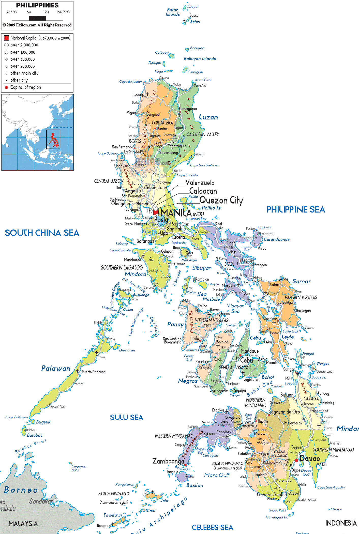
Description: Detailed large political map of Philippines showing names of capital city, towns, states, provinces and boundaries with neighbouring countries.

Map of the Philippines with cities, towns, and regions, and their locations. It is a detailed map showing the various political divisions and settlements. It shades each area or group of islands and marks the cities, municipalities, and towns of the region.
This is due to the emphasis on administrative units, city names, region labels, and road lines rather than physical relief. The map of the Philippines showing cities and towns is very useful in the classroom for teaching geography, trip planning, and seeing how various government services and population centers are distributed.
The map shows the country's three major island groups: Luzon, Visayas, and Mindanao. Additionally, the Philippines' regions map shows the formal designation of the regions as administrative groupings.
Major regions of the Philippines are located on Luzon, the largest island. Included among areas in Luzon are the Ilocos Region, Cagayan Valley, Central Luzon, CALABARZON, MIMAROPA, Bicol Region, Cordillera Administrative Region, and the National Capital Region (NCR).
The central part of Visayas consists of Western Visayas, Central Visayas, Eastern Visayas, and Negros Island Region. The south is home to Mindanao, which has the following divisions: Zamboanga Peninsula, Northern Mindanao, Davao Region, SOCCSKSARGEN, Caraga, and BARMM.
The map depicts regional centers and cities in bold. In addition to the cities, there are smaller dots and letters for smaller towns and municipalities. This way, the map of the Philippines that shows cities is very detailed. So is the map of the Philippines showing towns and villages.
The countries and oceans surrounding the archipelago are shown on the map. These include Malaysia and Indonesia to the south and southwest, the South China Sea to the west, and the Philippine Sea and Celebes Sea to the east and south. This context helps not only travelers, but also students, see how the Philippines fits into Southeast Asia.
The National Capital Region (NCR) is clearly labeled on the map of Philippine cities around Manila Bay, which notes “Manila” as the national capital. Surrounding Manila, the map labels major highly urbanized cities such as Quezon City, Caloocan, Valenzuela, Pasig, as well as Makati and Pasay, all of which form the metropolitan center of the Philippines.
The cities of “NCR” are closely clustered, with good road links between them, which shows any reader that NCR is a densely populated urban area and the country's administrative, financial, and cultural center.
The map of the Philippines with cities and regions also shows that NCR is located in Luzon and near the provinces of Central Luzon and CALABARZON, where other rising cities are found, namely Angeles, San Fernando, Antipolo, Dasmariñas, and Bacoor.
For the people living there, this part of the map shows which parts of town are in the metropolitan area proper and which are out but in an adjacent province. For visitors, it helps them plan day trips or find out where commuters go to and from Manila.
By glancing northward on the Philippines map with cities, you reach the Ilocos Region along the northwestern coast of Luzon. Some of the region's crucial coastal cities include Laoag, Vigan, and San Fernando (La Union).
The Cordillera Administrative Region, slightly inland, is denoted by highland provinces and cities, including Baguio and Tabuk, which serve as administrative centers for upland folks. In the Cagayan Valley region, further northeast, Tuguegarao cities and towns line the broad lowlands. This gives readers insight as to how these settlements follow the valley corridor towards the north coast.
The different-colored boundaries and labels show the titles in the high-quality map of the Philippines' Northern Luzon Regions. Geography students can memorize the provinces and cities in the regions. Using the Philippines map with towns and villages, residents and domestic travelers can trace light road lines for Baguio to Manila or Laoag to Tuguegarao to help plan long overland travel through Luzon.
The political map of the Philippines shows that just north and south of the NCR, Central Luzon and CALABARZON are heavily populated and economically important. The Central Luzon map shows cities including Angeles, San Fernando, Tarlac, Olongapo, and Cabanatuan, which are located mostly along major road and rail routes from Manila to northern Luzon.
In the provinces south of the capital region, CALABARZON includes the highly urbanized centers of Antipolo, Bacoor, Dasmariñas, Calamba, and Lipa, which are distinctly marked and connected by roads to Manila and other adjacent provinces.
The map of the Philippines with cities and regions shows a combination of city labels and road lines, which is especially useful for commuters between these cities and the NCR, as well as for understanding daily movement in this part of the Philippines.
The regional boundary lines also indicate the political structuring of these urban belts. With the regional boundary, they will know which local government and regional offices serve them. It helps students understand the spread of industrial and residential areas around the capital.
On the map of the Philippines with towns, south is the region known as MIMAROPA. This region consists of island provinces such as Mindoro, Marinduque, Romblon, and Palawan. All of these islands have outlines, along with representations of their major towns. Puerto Princesa, located on Palawan, and Calapan, on Mindoro, are prominently labeled to show where the regional and provincial administrations are based in this part of the archipelago.
Located southeast of Luzon's main island are the Bicol provinces of Albay, Camarines Sur, and Sorsogon, with the cities of Legazpi, Naga, and Sorsogon City dotting the peninsula. The provincial capitals of Batangas, San Pablo, and Lucena, along with the ferry ports of Batangas City and Atimonan, and the provincial capital and coastal town of Tayabas, clearly show this; all these terminal towns receive significant traffic from and to other cities.
There is no denying that Visayas plays an important role in the geography of the Philippines. You can find it at the center of the archipelago, with cities and regional links to Luzon and Mindanao. The Western Visayas, Central Visayas, Eastern Visayas, and Negros Island Region have their own color and label.
Major cities are highlighted through bigger fonts or bolder icons. In Western Visayas, the map shows that Iloilo City and Bacolod City are the two major urban areas on Panay and Negros Islands, respectively. Further, smaller towns refer to the coastlines and the interior road networks.
In Central Visayas, the map highlights Cebu City, Mandaue, and Lapu-Lapu City, which are clustered in the region's central part, suggesting a metropolitan surrounded by island municipalities. The map also features Tacloban and Ormoc, clearly marked as regional centers on Leyte, while the towns and municipalities of neighboring Samar and other islands are visible in smaller print.
This map is an excellent guide for travelers, showing ferry points, urban centers, and provincial capitals in the Visayas. It also lets residents see where their city lies in relation to other islands.
There is Mindanao, the large island that occupies the southern third of the country. A map of the Philippines with towns and villages helps you get oriented. The Central Visayas region is highlighted by its major urban centers, notably Cebu City, which is a major center of trade, commerce, education, and religion in Eastern and Southeastern Asia.
In the northeast, the Caraga Region has cities such as Butuan. Along this area facing the Philippine Sea are smaller towns. These urban centers are all clearly marked for ease of use. Users can see how to plan their routes. Moreover, they will know which urban center manages that coastal area.
These northern Mindanao areas are well mapped in the Philippine cities, besides other boundaries. The Davao region and the Zamboanga Peninsula are the various areas with an organized structure. As elsewhere, the mix of provincial capitals, large cities, and secondary towns enables residents, travelers, and geographers to see both regional structure and local detail at a glance.
Located on the southeast side of Mindanao is the Davao Region, which dominates the map of the Philippines with its cities. Davao City is among the largest cities in the country. According to the map, Davao is located on the coast facing the Davao Gulf.
Neighboring cities and municipalities are arranged along the roads that radiate inland and along the shore. The region of SOCCSKSARGEN in the southwest includes important cities such as General Santos City and Koronadal, which are centers of agriculture and trade in southern Mindanao.
The Zamboanga Peninsula is located in the southwest of Mindanao. Zamboanga City is listed in the west with smaller towns extending along the peninsula towards the Sulu Sea.
The areas that will make up the Bangsamoro Autonomous Region in Muslim Mindanao (BARMM) include western Mindanao (especially the Zamboanga Peninsula) and the Sulu archipelago and parts of central Mindanao (especially the Liguasan Marsh).
Cities and municipalities are indicated to show the political structure of the ARMM within the national framework. The way the regions are drawn on the map of the Philippines makes it easy for foreigners and outsiders to understand the country's complex political setup, neighboring waters, and regional context.
An important feature of this map of the Philippines with cities and towns is that it includes the surrounding seas and countries. The South China Sea is situated to the west of Luzon and Palawan, while the Philippine Sea lies to the east of Luzon and the Visayas.
Meanwhile, the Sulu Sea and Celebes Sea border Palawan and Mindanao to the southwest and south, respectively. The southern edge of the map shows some parts of Malaysia and Indonesia. Users get an idea of how the Philippines fits into maritime Southeast Asia and the international boundaries.
For travelers with regional travel plans, this context is key. For students, the map supports teaching and learning on how political boundaries are interspersed with larger regional groupings in ASEAN. The terms "South China Sea" and "Philippine Sea" often appear together with "map of Philippines cities" in search queries. Thus, their presence on the map and in the text indicates that this detailed map serves a whole range of informational needs.
Even if the political map of the Philippines with regions does not show every highway classification in detail, it does show a web of light-colored road lines connecting cities and municipalities. On Luzon, road markings identify routes from Manila to Baguio, Laoag, Tuguegarao, Naga, and Legazpi, showing how the main island is knit together for overland travel.
In the Visayas, shorter lines illustrate how ferries and roads connect Cebu City with nearby islands and link Iloilo, Bacolod, Tacloban, and other centers, helping residents and guests envision inter-island journeys.
The routes linking Cagayan de Oro, Davao, General Santos, Zamboanga, and Butuan in Mindanao show the main corridors enabling the movement of goods and passengers in the southern island. The roads are clearly drawn on this Philippines map, with cities and towns, allowing the reader to infer travel times and plan itineraries, such as which towns are likely to serve as transport or stopover hubs.
The political map of the Philippines, with towns and villages, and its legend uses symbol size to show urban settlement hierarchy. The largest cities, such as Quezon City, Manila, Davao, Cebu City, Zamboanga, and Cagayan de Oro, are represented by large icons.
These places have populations of hundreds of thousands or more. Medium-sized dots signify highly urbanized cities and independent components that serve as regional/provincial centers; smaller dots indicate component cities and municipalities scattered across the countryside.
This visual code is an effective way for geography students to determine which cities lie at the center of the region. Moreover, which smaller towns relate to the overall settlement pattern? People can quickly locate the closest metropolitan city for recruitment, such as higher education institutions or tertiary hospitals.
Similarly, passengers can see the city where they will likely find an airport or a large bus terminal. The map is very useful and expected by users searching for a map of Philippine cities or a map of the Philippines with towns, given this kind of hierarchical information.
The Philippines map with cities and regions serves many stakeholders by unifying provinces, regions, cities, towns, roads, seas, and neighboring states. Community members will be able to identify the region they belong to.
They will also view the sites of their regional and provincial capitals. In addition, they will be able to visualize road connections to other parts of Luzon, Visayas, or Mindanao. The Philippines map with cities and towns is useful for travelers plotting trips that make sense in terms of distances, moving in tandem along key destinations such as Manila, Baguio, Vigan, Cebu City, Iloilo, Davao, Zamboanga, and General Santos, with the smaller towns marked along this route per the traveler's stopovers.
The map of the Philippines with regions is a handy case study for geography students of an archipelagic state. It is organized into 18 administrative regions in three main island groups. The map's political outlook, including boundaries, labels, and city hierarchies, makes it suitable for lessons on regional planning, population distribution, and administrative geography, without the distraction of physical features such as elevation or hydrography.
The Philippines is located in Southeast Asia between the South China Sea and the Philippine Sea.
The three major island groups shown are Luzon, Visayas, and Mindanao.
The map shows the Philippines divided into 18 administrative regions.
Manila is shown as the national capital on the western side of Luzon.
Major cities shown include Manila, Quezon City, Cebu City, Davao City, Zamboanga City, Cagayan de Oro, Iloilo City, and General Santos.
Quezon City is located within the National Capital Region near Manila.
NCR stands for National Capital Region, the metropolitan area surrounding Manila.
Cities shown include Manila, Quezon City, Makati, Pasig, Pasay, Caloocan, and Valenzuela.
Baguio is located in the Cordillera Administrative Region in northern Luzon.
Northern Luzon cities shown include Laoag, Vigan, Tuguegarao, Tabuk, and Baguio.
Regions shown in Luzon include Ilocos Region, Cagayan Valley, Central Luzon, CALABARZON, MIMAROPA, Bicol Region, CAR, and NCR.
Central Luzon is located north of Metro Manila on Luzon Island.
Cities shown include Angeles, San Fernando, Tarlac, Olongapo, and Cabanatuan.
Cities shown include Antipolo, Bacoor, Dasmariñas, Calamba, and Lipa.
Palawan is located southwest of Luzon in the MIMAROPA Region.
Cities shown include Puerto Princesa and Calapan.
Cities shown include Legazpi, Naga, and Sorsogon City.
Cebu City is located in Central Visayas in the middle of the Philippine archipelago.
Major Visayas cities include Cebu City, Iloilo City, Bacolod City, Tacloban, Ormoc, and Dumaguete.
The Visayas regions shown are Western Visayas, Central Visayas, Eastern Visayas, and Negros Island Region.
Davao City is located in southeastern Mindanao near Davao Gulf.
Mindanao cities shown include Davao City, Zamboanga City, Cagayan de Oro, Butuan, General Santos, and Koronadal.
Mindanao regions shown include Northern Mindanao, Davao Region, SOCCSKSARGEN, Caraga, BARMM, and Zamboanga Peninsula.
Zamboanga City is located on the Zamboanga Peninsula in western Mindanao.
The map shows the South China Sea, Philippine Sea, Sulu Sea, and Celebes Sea.
Malaysia and Indonesia appear south and southwest of the Philippines.
Yes, the map clearly shows regional and provincial administrative boundaries.
Yes, the map is useful for studying island groups, regions, cities, and political geography.
Yes, travelers can use the map to understand ferry routes, cities, regions, and inter-island travel corridors.
No. Printing or copying maps from this site is not permitted.

Physical Map of Philippines
Physical map and map image of Philippines.

Road Map of Philippines
Road map and map image of Philippines.

Regional Directory of United States of America
Information and guide about United States of America and websites with American topics.

Regional Directory of Europe
Information and guide about Europe and websites with European topics.

Regional Directory of Australia
Information and guide about Australia and websites with Australian topics.