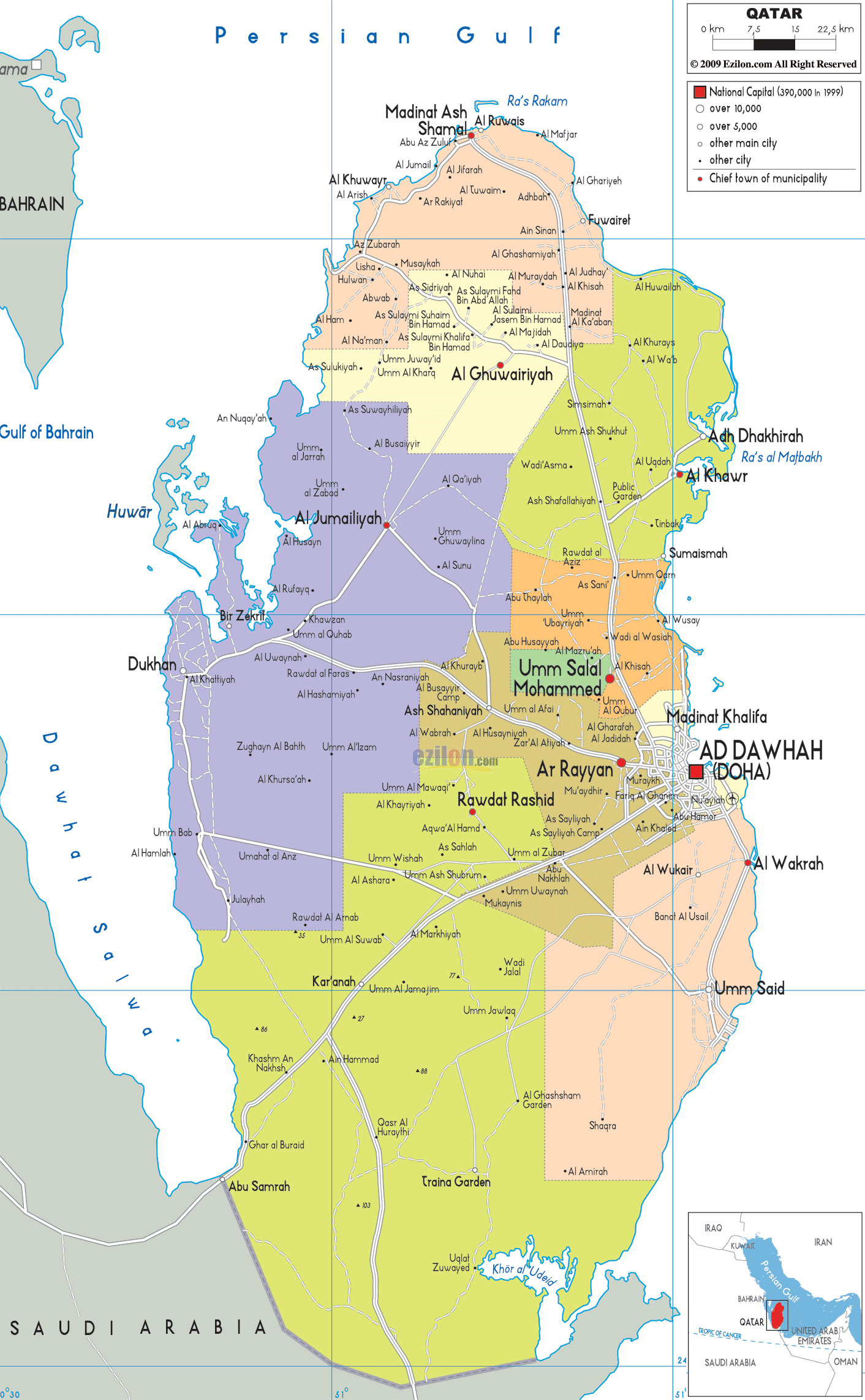
Description: Detailed large political map of Qatar showing names of capital city, towns, states, provinces and boundaries with neighbouring countries.

The Map of Qatar presented here provides a clear, structured view of one of the most distinctive peninsulas in the Middle East. As you visually follow the map, you immediately notice that Qatar extends northward into the Persian Gulf, forming a narrow landmass surrounded by water on three sides. This geographic feature makes Qatar unique compared to many other countries in the region.
The map shows Qatar's only land border to the south with Saudi Arabia, while the sea surrounds the rest of the country. To the northwest, across the water, we find Bahrain, which is also visible on a regional map. Additionally, Qatar's geolocation played a significant role in advancing these transactions.
The map details the municipalities, major cities, and road-light connections of Qatar. It illustrates the country's geographic organization. This map shows that, from its northernmost point in Scandinavia to its southernmost point at the border of Alborz Province, coastal cities smoothly transition into the interior deserts, with little grassland, shrubs, or similar vegetation in between.
Situated on the eastern-central coast, Ad Dawhah (Doha) is the capital and largest city of Qatar. The country's political, economic, and cultural capital, Doha, is situated on the Persian Gulf.
The urban area of Doha is bordered by other urban areas, including Al Wakrah, Madinat Khalifa, and Ar Rayyan. As noted, the above cities are connected by a network of roads originating in the country's capital.
Doha's location on the sea is very important because of its link with trade routes, tourism, and urban development. The map shows that most of Qatar's population is concentrated in that area and its surroundings.
Moving slightly inland from Doha, the map reveals Ar Rayyan, one of Qatar's largest municipalities. This place marks the transition from the city to the space beyond the coast.
Ar Rayyan are connected to Doha via major roadways and are shown as clean, light lines on the map. The movement process links different residential areas with the very important capital.
The presence of landmarks such as Education City and sports complexes in this region makes it one of the most dynamic areas in Qatar's development.
North of Doha, the map shows Umm Salal Mohammed, a key municipality that acts as a bridge between the capital and northern Qatar. The map shows how central it is, an important connector between urban and rural areas.
The road-light network shows lines extending from Umm Salal towards Doha as well as cities to the north, such as Al Khor. Due to its small size, the country's movement is quite easy.
As you continue following the map northward, you reach Al Khor, one of the most important northern cities in Qatar. Located along the northeastern coastline, Al Khor is clearly marked and connected by major road routes leading back to Doha.
The map also shows nearby settlements such as Adh Dhakhirah, emphasizing the spread of coastal communities in this region. These areas have access to the sea, which supports fishing, commerce, and modern development.
Though the northern coastline does not seem as densely settled as in Doha, these towns show that Qatar has a good distribution of settlements along its eastern coast.
The northernmost municipality, Al Shamal, is at the very top of maps. The peninsula's end is where important places like Madinat ash Shamal and Al Ruwais are located.
This map shows how this area could extend towards the Persian Gulf. On the whole, Al Shamal may not have many inhabitants, but it plays an important role in maritime access and national identity.
The road connections from Al Shamal down to Al Khor and Doha demonstrate how some of Qatar's most isolated corners have been linked to the capital.
The map bears Al Daayen. Just north of Doha, the municipality is developing fast. This area reflects Qatar's expansion with the development of new residential and commercial districts along major road corridors.
Due to its proximity to Doha, the site provides an ideal context for urban growth, and the map illustrates its uptake into the capital.
Al Wakrah, one of the country's most important coastal cities, is south of Doha. Its location on the shore gives it a dual role as a living and economic center.
The road-light network connects Al-Wakrah directly with oha and continues south to industrial zones. Through this connectivity, persons and goods move across the region.
Further south, the map shows Umm Said (Mesaieed), an industrial city known for its role in Qatar's energy sector. Its location along the southeastern coast highlights its importance for export and industrial activities.
The map also shows how this region connects to inland roads leading toward the southern border with Saudi Arabia.
Going west from Doha reveals Al Shahaniya on the map, a municipality of Qatar's interior desert. Though less populated, this is important for traditional activities. Examples of such activities are camel racing and desert tourism.
The map showed a controlled approach, indicating that the coastal urban areas were generally free of inland desert settlements.
The map shows Qatar's southern border with Saudi Arabia. This area includes Abu Samrah, which is used as a crossing point.
The land here is almost entirely desert, with hardly any settlements, indicating that most of Qatar's population lives along the east coast.
Qatar is located in the Middle East on a narrow peninsula extending into the Persian Gulf, positioned east of Saudi Arabia and surrounded by water on three sides.
Doha (Ad Dawhah) is the capital and largest city, serving as the political, economic, and cultural center of the country.
The Persian Gulf surrounds Qatar, shaping its coastline, economy, and maritime connections.
Major cities include Doha, Al Wakrah, Al Khor, and Ar Rayyan, all connected through a modern road network.
Al Khor lies in northeastern Qatar along the coast and is one of the country’s key northern cities.
Ar Rayyan is a major inland municipality west of Doha known for residential expansion and institutions.
Al Wakrah is located south of Doha along the eastern coastline and continues to grow rapidly.
Umm Salal is a central municipality north of Doha that connects the capital to northern regions.
Al Shamal is the northernmost region of Qatar, including towns such as Al Ruwais.
Yes, Qatar shares a single land border with Saudi Arabia in the south.
Mesaieed is an important industrial city in southern Qatar focused on energy and exports.
Yes, most of Qatar is covered by flat desert terrain with sparse vegetation.
The map shows cities, municipalities, coastline, and major roads for navigation and understanding.
Doha is located on the eastern coast facing the Persian Gulf.
Al Daayen is a fast-growing municipality north of Doha.
Dukhan lies on the western coast and is known for oil production.
Al Shahaniya is an inland desert region known for camel racing and open landscapes.
The southern border connects Qatar to Saudi Arabia at Abu Samrah.
Al Udeid is located in southern Qatar and is known for its air base.
Qatar has a long and relatively smooth coastline along the Persian Gulf.
Al Ghuwayriyah is a northern inland area connecting central and northern Qatar.
Ras Laffan is a major industrial coastal area located north of Doha.
Qatar Bay refers to the coastal waters surrounding Doha’s waterfront.
Cities are connected through a modern highway system centered around Doha.
The Doha metropolitan region is the most populated part of Qatar.
Northern Qatar features coastal towns with open desert landscapes inland.
Southern Qatar is largely desert with industrial zones and border crossings.
Qatar is known for its peninsula shape, desert terrain, and coastal urban development.
Yes, it is useful for students, travelers, and researchers studying Qatar geography.
No. Printing or copying maps from this site is not permitted.

Physical Map of Qatar
Physical map and map image of Qatar.

Road Map of Qatar
Road map and map image of Qatar.

Regional Directory of United States of America
Information and guide about United States of America and websites with American topics.

Regional Directory of Europe
Information and guide about Europe and websites with European topics.

Regional Directory of Australia
Information and guide about Australia and websites with Australian topics.