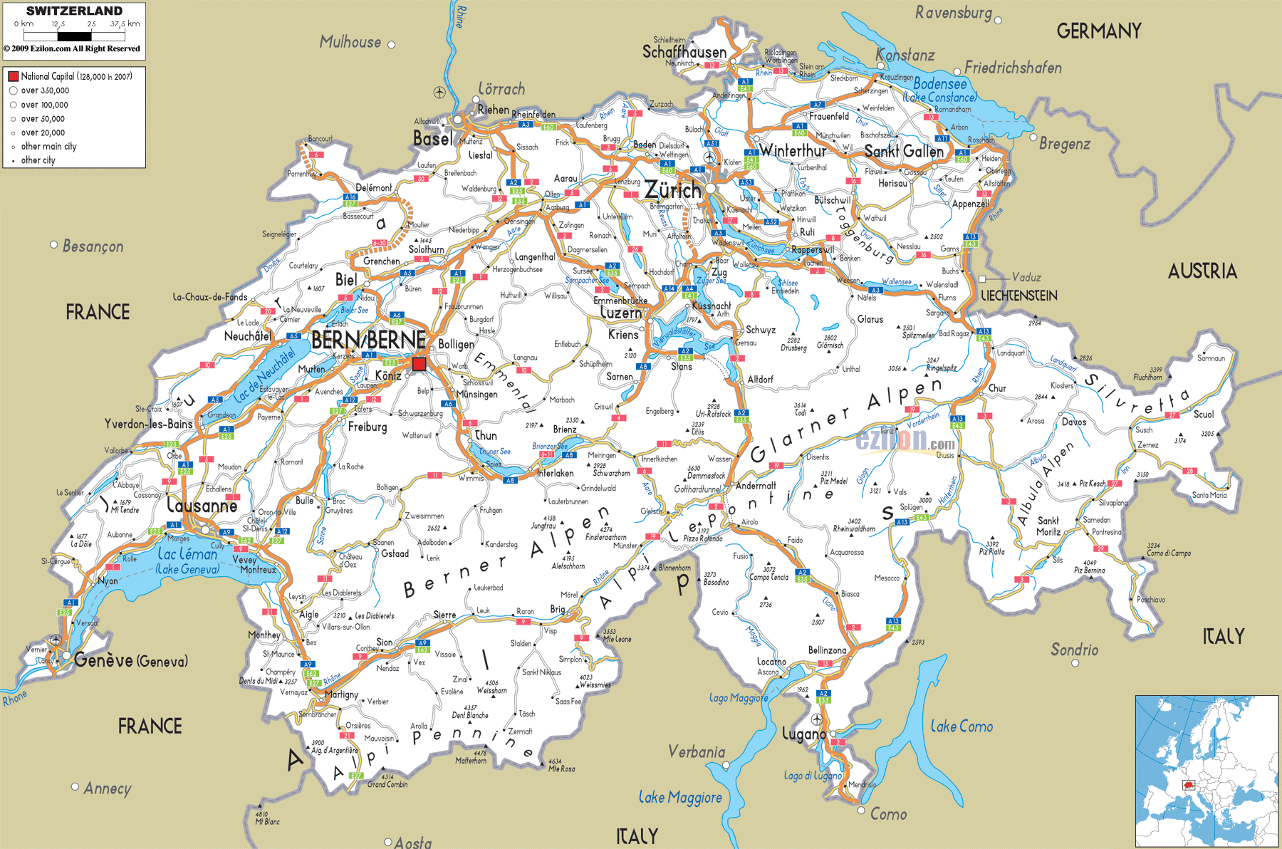
Description: Detailed clear large road map of Switzerland with road routes from cities to towns, road intersections / exit roads in regions, provinces, prefectures, also with routes leading to neighboring countries.
 Not merely a map but an invitation to a land which has moved mountains for the sake of roads and railways. Your drive to work might just be the most beautiful in the world!
In Switzerland, taking you from A to B is about getting somewhere appealing. Man's attempt to bring men together against all odds is thus the journey by roads along the almost perfect landscape.
Imagine starting your journey in Geneva, where the morning mist rises from Lake Geneva and the Mont Blanc massif gleams in the distance. The A1 Autobahn begins here, and what a beginning it is! This isn't just Switzerland's longest highway, it's your personal tour guide across the entire country.
As you leave Geneva behind, you'll find yourself hugging the northern shore of Lake Geneva, with vineyards cascading down hillsides to your right and the lake's deep blue waters stretching toward the French Alps on your left. The highway engineers here faced a delicate challenge: how do you build a major transportation corridor through one of Europe's most scenic regions without destroying what makes it special? Their solution was pure Swiss genius—elevated sections that seem to float above the landscape, tunnels that preserve hillside communities, and curves that frame the scenery like a master photographer composing the perfect shot.
Lausanne appears ahead like a amphitheater rising from the lake, its cathedral spire piercing the sky. Here, the A1 threads through the city with the precision of a Swiss watchmaker, connecting to local roads that spiral up into the Jura Mountains or down to lakeside villages where time seems to move at the pace of lapping waves.
Continuing northeast, you'll experience one of Switzerland's most dramatic geographical transitions. The gentle, wine-country landscape of Vaud gradually gives way to the rolling hills of the Swiss Plateau, and suddenly you're approaching Bern. The capital city spreads before you in its UNESCO World Heritage glory, its medieval towers and red-tiled roofs creating a skyline that hasn't changed much since the Middle Ages - except for the modern highway system that somehow manages to serve this ancient city without overwhelming it.
From Bern, the A1 begins its final push toward Zurich, and this is where you really understand what Swiss highway engineering is all about. The road climbs and dips through countryside that looks like it was designed by a landscape artist - emerald pastures dotted with picture-perfect farmhouses, forests that seem to glow with an inner light, and always, always, the Alps rising in the distance like a promise of adventures to come.
Zurich announces itself long before you see the city proper. As the cars get thicker, the expressway gets wider and you are suddenly in one of Europe’s advanced urban transport networks. But even at the centre of the country’s economic capital, the shoreline of lake Zurich reaches out towards the mountains.
The A1 doesn't end in Zurich, it continues east through Winterthur and on toward St. Gallen, but by now you understand what makes this highway special. Not just a road, but a path through which Switzerland’s French-speaking west meets its German-speaking east, its international sophistication meets its rural traditions, its cities meet its villages.
If the A1 is Switzerland's cultural journey, then the A2 is its epic adventure story. Starting in Basel, where the Rhine River carries the dreams and commerce of half of Europe, this highway sets out on what might be the most dramatic road trip on the continent.
Basel itself is a transportation marvel, a city where three countries meet and somehow manage to share highways, airports, and even tram lines. The A2 begins here with connections that can take you to Paris, Frankfurt, or Milan without ever leaving the highway system. But today, you're heading south into the heart of Switzerland.
The early stretches of the A2 might lull you into thinking this will be an easy drive. The highway through the Aare River valley bumps through Swiss countryside - nice farms and tidy villages, church spires that seem to compete with each other. I travel through Olten and Aarau, towns that effortlessly connect to the highway. This is quite a feat in other Western nations.
But then you reach Lucerne, and everything changes. Suddenly, the gentle hills of the Swiss Plateau give way to something altogether more dramatic. Lake Lucerne spreads before you like a fjord, its deep blue waters reflecting peaks that rise almost vertically from the shoreline. This is your first taste of what's coming—the A2 is about to take you into the high Alps.
The approach to the Gotthard Pass is one of the world's great driving experiences. The highway begins to climb, and with each kilometer, the landscape becomes more dramatic. Valleys deepen into gorges, waterfalls cascade from impossible heights, and the peaks around you grow taller and more imposing. You're following a route that has connected northern and southern Europe for over 800 years, but you're doing it in comfort and safety that medieval travelers could never have imagined.
Then comes the Gotthard Road Tunnel - 17 kilometers of engineering that represents one of humanity's greatest victories over geography. When stepping into this tunnel, you go underneath some of the most challenging terrain in Europe. When you come out on the southern side, you are in a different world. The architecture has been modified, the vegetation is more Mediterranean, even the luminosity seems different. You have crossed over to the Italian Switzerland from Germanic Switzerland thanks to the A2.
The descent toward Lugano is every bit as spectacular as the ascent was dramatic. The highway threads through valleys that seem carved by giants, crosses viaducts that span impossible gorges, and somehow maintains highway speeds through terrain that would challenge a mountain goat. Bellinzona appears below you like a medieval fortress guarding the southern approaches to the Alps, its three castles reminding you that this route has been strategically important for centuries.
Lugano welcomes you with palm trees and a Mediterranean atmosphere that seems impossible after the Alpine drama you've just experienced. But that's Switzerland for you - a country where you can experience multiple climates, cultures, and landscapes within a few hours' drive.
The A3 might be less famous than its siblings, but it offers its own unique perspective on Swiss geography and culture. Beginning in Basel alongside the A2, it strikes out toward Zurich through countryside that showcases a different side of Swiss character.
This route takes you through the Aargau region, where Swiss pragmatism and prosperity are on full display. The roads not only the ropes but also link many small and medium cities that constitute the backbone of Swiss industry and commerce. The thermal spa town of Baden is evidence of Switzerland’s ability to combine modern inventions with ancient traditions.
When approaching Zurich from the west, you get great views of Zurich and Lake Zurich already on the A3. But the highway doesn't stop there - it continues southeast toward Chur and the Graubünden region, taking you into some of Switzerland's most dramatic Alpine scenery.
The stretch of highway between Zurich and Chur is an engineering triumph. The roadway has to go between Lake Zurich and the climbing foothills of the Alps in a cozy and orderly manner. Rapperswil is known as the “City of Roses” and is found at the end of a peninsula that juts into the lake. It is linked to the highway with bridges that seem to float on water and makes for a different scenic view of the snow-capped Alps.
Chur, Switzerland's oldest city, marks the beginning of the A13 and your gateway to the Graubünden Alps. From here, roads branch toward St. Moritz, Davos, and some of Europe's most exclusive mountain resorts. But they also connect isolated valleys where ancient traditions survive and where the landscape remains largely unchanged from centuries past.
The A13 represents perhaps the ultimate expression of Swiss highway engineering. Beginning in Chur, this highway takes you into the Graubünden region, where the challenges of building roads through high Alpine terrain have pushed engineers to create solutions that seem to defy the laws of physics.
The route follows the Rhine Valley south from Chur, but this isn't the mighty Rhine you know from northern Europe. Here, it's a mountain stream rushing through valleys so narrow that finding space for a highway required tunnels, viaducts, and engineering solutions that are works of art in their own right.
Thusis marks the beginning of the most dramatic section, where the highway begins its climb toward the San Bernardino Pass. The Via Mala gorge, one of Switzerland's most spectacular natural features, required highway engineers to literally carve a path through solid rock. The result is a road that seems to hang in space, offering views that will make you understand why this region has inspired artists and writers for centuries.
The San Bernardino Tunnel allows year-round travel through terrain that would otherwise be impassable for months each year. When you emerge on the southern side, you're in Ticino, Switzerland's Italian-speaking region, where the architecture, cuisine, and even the light remind you that you're now closer to Milan than to Zurich.
The A9 offers a completely different Alpine experience, following the Rhône Valley from Lausanne toward the Simplon Pass and the Italian border. This highway takes you through the Valais region, where some of Europe's highest peaks create a landscape that's both beautiful and challenging.
Martigny lies at the junction of the main Rhône Valley with several side valleys leading to Verbier, Chamonix, and many other famous destinations. Spanning narrow gaps between river and valley cliffs, the corridor seeks to create an efficient and aesthetically pleasing highway here.
Sion, the capital of Valais, appears ahead like something from a fairy tale, its twin hills topped with medieval castles and its vineyards climbing impossibly steep slopes. The highway here includes some of Switzerland's most spectacular bridges, spanning the Rhône and its tributaries while providing access to side valleys that lead to world-famous ski resorts.
As you make your way towards Brig and the Simplon Pass, the scenery becomes more and more eye-catching. The mountains around you are among the highest in Europe, and the road must wind its way through an area that has been shaped by glaciers, avalanches and unforgiving Alpine weather.
The Jura Mountains roads, running along Switzerland's western border, provide a glimpse into Swiss transport engineering of a different type. They're not the Alpine highways that get the press, but they’re just as important for linking and maintaining Switzerland as Europe’s crossroads.
Neuchâtel, sitting on the shore of its namesake lake, is connected to the national highway system by roads that thread through the Jura's rolling hills and deep valleys. The A5 provides connections to Biel/Bienne and the broader Swiss network, while local roads connect to French highways and the broader European system.
The A16 is Switzerland’s latest autobahn. It connects the Jura area to Basel and the national motorways. Constructing this highway necessitated some of the most difficult tunnel-building work in Swiss history, as much of the route runs through the Jura Mountains to connect isolated communities to the rest of Switzerland’s transport network.
Graubünden has an extensive road network beyond the A13 that enters valleys that feel nearly untouched by developments. The ride to St. Moritz through the Engadin Valley is so beautiful that it seems equally as beautiful as the St. Moritz itself.
Davos famous for its yearly World Economic Froum and its ski resorts are linked to the highway net by roads which ascend through among the hardest terrain in Switzerland. The Wolfgang Pass and the Flüela Pass are other routes that are more scenic in Alpine engineering terms.
The road through the Bernina Pass, although not part of the Autobahn system, is one of Switzerland’s greatest mountain roads. This route runs from St. Moritz to Tirano, Italy passing through glacier, alpine lakes, and towering peaks of the magnificent Swiss Alps.
Zurich's urban highway network is a marvel of planning and engineering that somehow manages to serve one of Europe's most important economic centers while preserving the city's livability and connection to its natural setting.
The A1, A3, A4 and A15 converge in the Zurich metropolitan area. The traffic volumes on these connection segments are enormous. Nevertheless, they do ensure Access to Zurich airport, the city, and the highway system of Switzerland.
Lake Zurich creates special impediments for the highway planners as the road alignment should traverse between the lake shore and steep hills on the other side and also serve dense urban populations. Meanwhile, the tunnels are designed to preserve lakefront communities, while the elevated parts will boast spectacular views. Carefully conceived interchanges will maintain efficient traffic flow and avoid overwhelming nearby residential areas.
The major European international airport Zurich Airport is linked with the highway system. Certainly, the connections allow you to reach any corner of Switzerland, or even go to neighbouring countries without having to pass through the city.
Geneva's highway network reflects the city's unique position as both a Swiss city and an international center. The A1 terminates here after its cross-country journey, while connections to French highways make Geneva a crucial link between Swiss and European transportation systems.
Geneva Airport serves not just Switzerland but also southeastern France, with highway connections that include direct access to French roads without entering Swiss territory. It reflects Geneva’s international profile and Switzerland’s down-to-earth approach to international cooperation.
The urban highway network of the city must accommodate not only local traffic, but also substantial international flows, such as the diplomatic flow to numerous international organizations based in Geneva. The structure consists of several lake crossings and connections to Swiss and French motorways.
The roads in Bern, Switzerland focus on easy transport but pay a lot of attention to beauty. The A1 passes through the metropolitan area while the city center, a UNESCO World Heritage site, remains largely free of highway traffic.
A6 motorway offers connection to Basel and Northern Switzerland. Similarly A12 to Fribourg and Lake Geneva region. Roads that can be used for serving the administrative capital functions of the cities and to retain the city’s character as a liveable city.
Switzerland's border with Germany has many highway crossings, showing the economic and cultural relationships between the two countries. Basel is the main crossing point with its highways connecting directly to the German autobahn and to Frankfurt, Stuttgart and other German cities.
Schaffhausen, positioned on the Rhine River near the famous Rhine Falls, provides another important crossing point with connections to southern Germany and Austria. The highway approaches to these crossings include some spectacular scenery, particularly the views of the Rhine Falls that make this one of Europe's most scenic border crossings.
Konstanz and the Lake Constance region represent a unique tri-national area where Swiss, German, and Austrian highways converge around one of Europe's largest lakes. The highway system here requires careful coordination between three different countries' transportation authorities.
Swiss-French border crossings vary from major frontiers to scenic mountain passes. Geneva is the main crossing point with direct connections to French motorways that link to Lyon, Paris and the south-east of France.
The Jura Mountains have some smaller crossing points for regional traffic which provide access to ski resorts in France and mountain communities. The nature crossings often feature stunning landscapes and capture the spirit of cross-border cooperation that makes European travel so simple.
Switzerland's southern border with Italy includes some of Europe's most dramatic highway crossings. The Gotthard route via the A2 connects to Italian highways that provide access to Milan, Rome, and southern Italy, making this one of Europe's most important north-south transportation corridors.
The San Bernardino Pass route via the A13 provides an alternative connection to northern Italy, while the Simplon Pass route connects the Valais region to Italian highways. Crossings testify to the evolution of engineering: from Roman roads, to medieval trade routes, to highways and more.
Switzerland's eastern border with Austria includes highway connections that link Switzerland to central and eastern Europe. The A13 continues past the Swiss border while connecting with Austrian highways, which connect to Innsbruck, Vienna and the rest of the European highway network.
Shared by Switzerland and Austria, the region of Arlberg has highway connections that have served as essential corridors of transport in Europe for centuries. Modern highway engineering has improved these historic routes while maintaining their role as vital links between different regions of Europe.
Switzerland's awesome mountain passes are a dream for anyone who enjoys driving. But they also remind us that, while nature was tamed, it is still bound by rules of its own. The Great St. Bernard Pass, Furka Pass, Grimsel Pass, and Susten Pass are normally closed from November to May. Hence, they are seasonal adventures. So, you must plan with respect for Alpine conditions.
The Great St. Bernard Pass, a link from Martigny to Aosta in Italy, follows a route which dates back to the Romans. The modern road features the Great St. Bernard Tunnel that permits year-round travel. However, the pass road provides the sort of experience that connects you with centuries of Alpine history.
The James Bond film “Goldfinger” made this pass famous, as it is one of the most spectacular drives in Switzerland. The road goes up to a height of over 2,400 meters. It provides very interesting views of glaciers, Alpine lakes, and peaks that seem to go on forever. This is a fair weather route, as snow undoes the road in winter.
Switzerland's highway system is designed with winter in mind, providing tunnel alternatives to most major passes that ensure year-round connectivity. The Gotthard Road Tunnel, San Bernardino Tunnel, Great St. Bernard Tunnel, and others represent billions of dollars in investment to ensure that Swiss communities remain connected regardless of weather conditions.
These tunnels do more than just transport goods and people; they allow isolated mountain communities to remain viable all year. These allow businesses, tourists, and people to continue their daily lives even when the passes are buried under metres of snow.
To thousands of residents in Switzerland, these roads are daily highways and not a tourism site. Imagine taking a scenic drive from your village in the Valais to work in Geneva every day. The diverse landscapes from rural area to city life is a beautiful experience. Or consider the residents of Graubünden who think nothing of driving to Zurich for shopping, their route including mountain passes that would be bucket-list destinations for visitors from flatter countries.
These roads enable a uniquely Swiss lifestyle where you can live in a traditional Alpine village but work in an international city, where your children can attend school in a place where three languages are spoken daily, where your weekend adventures might include skiing in the morning and swimming in a lake in the afternoon.
For visitors, Switzerland's road network opens up possibilities that would have been unimaginable just a few generations ago. You can have a breakfast on the shores of Lake Geneva, lunch in an unspoilt mountain village, and dinner watching the sunset over Lake Lugano: all thanks to roads making it unforgettable.
Dissociated from the “grand tour” of pre-history and beyond, all highways will allow tourism to hidden valleys, remote villages and lovely viewpoints not accessible by train and bus. They enable you to develop your own Swiss Adventure under your own interests and curiosity instead of preset routes.
These roads have other utility than for everyday travelling and tourism. In a mountainous country where the weather changes rapidly and natural events like avalanches, rockslides and the like occur, the road system provides access for emergency services and medical and disaster responses.
The engineering that goes into these roads includes sophisticated monitoring systems, avalanche protection, and emergency communication networks that help ensure safety even in challenging conditions. Every tunnel includes emergency exits, every mountain section includes weather monitoring, and every remote stretch includes emergency communication systems.
Switzerland’s road network is using technology in a sustainable way to respond to 21 century challenges. The road power use of electric vehicles will now become possible via an intelligent infrastructure which will integrate into the public transport system. The new stretches of highway will have electric vehicle charging stations, and older stretches are being equipped with smart traffic management systems that reduce congestion and emissions.
The country is also putting in place new fog-free Alpine transport systems, as well as new tunnel ventilation systems, wildlife crossing structures and sounding reducing technologies for the alpine highway transport systems.
Maintaining this incredible road network requires constant attention and significant investment. Swiss highway maintenance crews work year-round to keep roads safe and functional, from snow removal in winter to rockfall protection in summer. The engineering challenges of maintaining highways through some of the world's most challenging terrain require specialized equipment, highly trained personnel, and innovative approaches to infrastructure preservation.
When you look at this map, you don’t see lines, you see your invitation, a connection to a community, and a pathway to an unforgettable experience. Every red line is a designed highway which could give safe, efficient travel through the terrain considered impossible. Every orange line connects communities that have chosen to remain in some of the world's most challenging environments because the roads make it possible.
Whether you're a Swiss resident planning your daily commute, a business traveler crossing Europe, or a tourist eager to explore Alpine wonders, this road network has been designed with you in mind.
Next time you drive on a Swiss highway, don’t just think of where you are going, but rather the extraordinary journey that led to this beautiful road being created. Every tunnel takes years of planning and building. Every bridge overcomes obstacles. It also connects two communities with the world. Every curve has been designed for safety and beauty.
Switzerland gave the world a gift that may prove that getting there is half the fun – a road network that offers an adventure through some of the world’s most stunning scenery. Discover the Swiss Road Network, your gateway to adventure in the Alps and the heart of Europe.

Physical Map of Switzerland
Physical map and map image of Switzerland.

Political Map of Switzerland
Political map and map image of Switzerland.

Regional Directory of United States of America
Information and guide about United States of America and websites with American topics.

Regional Directory of Europe
Information and guide about Europe and websites with European topics.

Regional Directory of Australia
Information and guide about Australia and websites with Australian topics.