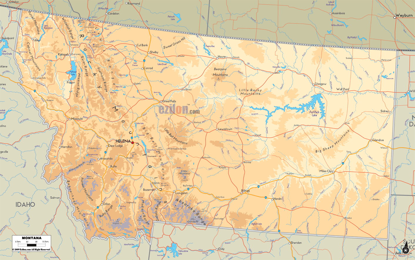

Description: The Physical map of Montana State, USA showing major geographical features such as rivers, lakes, topography and land formations.
 Introduction:
The Large, Detailed Physical Map of Montana unfolds an expansive geographical canvas inviting viewers to dive deeply into the state's magnificent natural terrains. With its nuanced portrayal of Montana's geographical features, this map is a treasure trove of information for explorers, students, and anyone who loves nature's artistry.
Often referred to as the "Big Sky Country" for its endless horizons, Montana's diverse landscapes range from towering mountain ranges to vast rolling plains. The map meticulously categorizes the state into its Southern, Northern, Eastern, Western, and Central areas, each with many natural wonders.
Through this narrative, we shall traverse through each of these geographical divisions, offering a detailed description to provide a robust understanding of what one can expect to find while traveling through the map of Montana, making it a comprehensive guide for both the curious mind and the avid traveler.
The map of Southern Montana is a dialogue in elevation and a testament to the forces of nature that have sculpted its terrain over millennia. The Absaroka and Beartooth Mountains are the area's primary focal points of interest. The map displays the tall peaks and rugged surfaces.
The splendor of these mountain ranges sets a majestic backdrop to the numerous valleys and rivers that crisscross this section of the map. One such river, the Yellowstone River, snakes its way through the landscape, its course elegantly depicted on the map, giving a sense of its lifeline to the region.
The Yellowstone National Park is an essential observation. The map in Montana has a clear marking indicating its location. The park, with its famed geothermal features, lush forests, and abundant wildlife, adds many colors and textures to the map. Moreover, the distinct contour lines on the map provide rich visual detail of the elevation changes, helping anyone keen on understanding the topographical diversity of Southern Montana with a thorough insight.
As we drift northward on the map, the majestic Rocky Mountain Front and the illustrious Glacier National Park come into focus. The map offers a meticulous representation of this region, illustrating the rugged topography marked by towering peaks, plunging valleys, and an intricate network of rivers and lakes.
The largest lake in the western part of the Mississippi River is Flathead Lake, which is of significant size. The map stands out due to its vibrant blue shade, strikingly contrasting the earthy greens and browns representing the nearby terrain.
Further towards the border with Canada, the map showcases the clear demarcation of international boundaries, extending Montana's geographical narrative into a transnational dimension. Amidst this wilderness, the map also details the small towns and road networks that hint at human habitation and connectivity in this remote yet awe-inspiring part of Montana.
Shifting focus towards Eastern Montana on the map, we transition from the rugged western terrains to the gentle, rolling plains that define this area. The map illustrates this transition with subtle color tones and contour line shifts. The Musselshell River and numerous smaller rivers and creeks punctuate the expansive plains, serving as a vital water source for wildlife and agriculture in the region.
The map also pays homage to the region's rich paleontological history by marking locations known for significant fossil discoveries. The intertwined narrative of ancient geological history with the present-day topographical features on the map offers a layered understanding of Eastern Montana's expansive plains and hills.
The Western region of Montana, as captured on the map, is where the ruggedness of nature is beautifully juxtaposed with the serenity of valleys and lakes. The Bitterroot Range, stretching along the border with Idaho, is a superb testament to Montana's mountainous identity. The map carefully outlines the peaks and valleys, providing a bird's eye view of this majestic landform. The detailing of elevations using contour lines on the map evokes a sense of the rugged topography that characterizes Western Montana.
With its gentle meander through the valleys, the Clark Fork River is a vital waterway, nurturing the lands and communities along its course. The map also portrays a robust network of roads connecting the remote communities nestled in the mountains, offering a glimpse into human resilience and connectivity amidst the grandeur of nature.
Central Montana, as depicted on the map, is a geographical symphony where the high plains seamlessly blend with the Rocky Mountains. With its historic course, the legendary Missouri River is a dominant feature on the map, symbolizing a historic pathway of exploration and settlement. The Little Belt Mountains and the Big Snowy Mountains emerge as significant landforms, their essence captured amid the broader topographical narrative of Central Montana on the map.
The interplay of various elevations, landforms, water bodies, and human settlements creates a rich tapestry that the map presents with accuracy and aesthetic appeal. The detailed cartography allows a viewer to appreciate the diverse geographies that converge in Central Montana, forming a unique blend of natural and human landscapes.
The Large, Detailed Physical Map of Montana is not merely a map; it's a journey through the diverse geographies that define this magnificent state. As one navigates through the South, North, East, West, and Central regions on the map, every turn, every elevation, and every water body narrates a story of the ancient forces that have shaped Montana.
The meticulous depiction of mountain ranges, rivers, lakes, and hills is an educational tool and an invitation to explore Montana's boundless beauty. With its rich detailing and segmented narration, this map offers a comprehensive visual guide, ensuring that the essence of Montana's breathtaking geography is captured and appreciated in full glory.

Counties and Road Map of Montana
Counties and Road map and map image of Montana.

Regional Directory of Canada
Information and guide about Canada and website listing.

Regional Directory of United States of America
Information and guide about United States of America and websites with American topics.

Regional Directory of Europe
Information and guide about Europe and websites with European topics.

Regional Directory of Australia
Information and guide about Australia and websites with Australian topics.