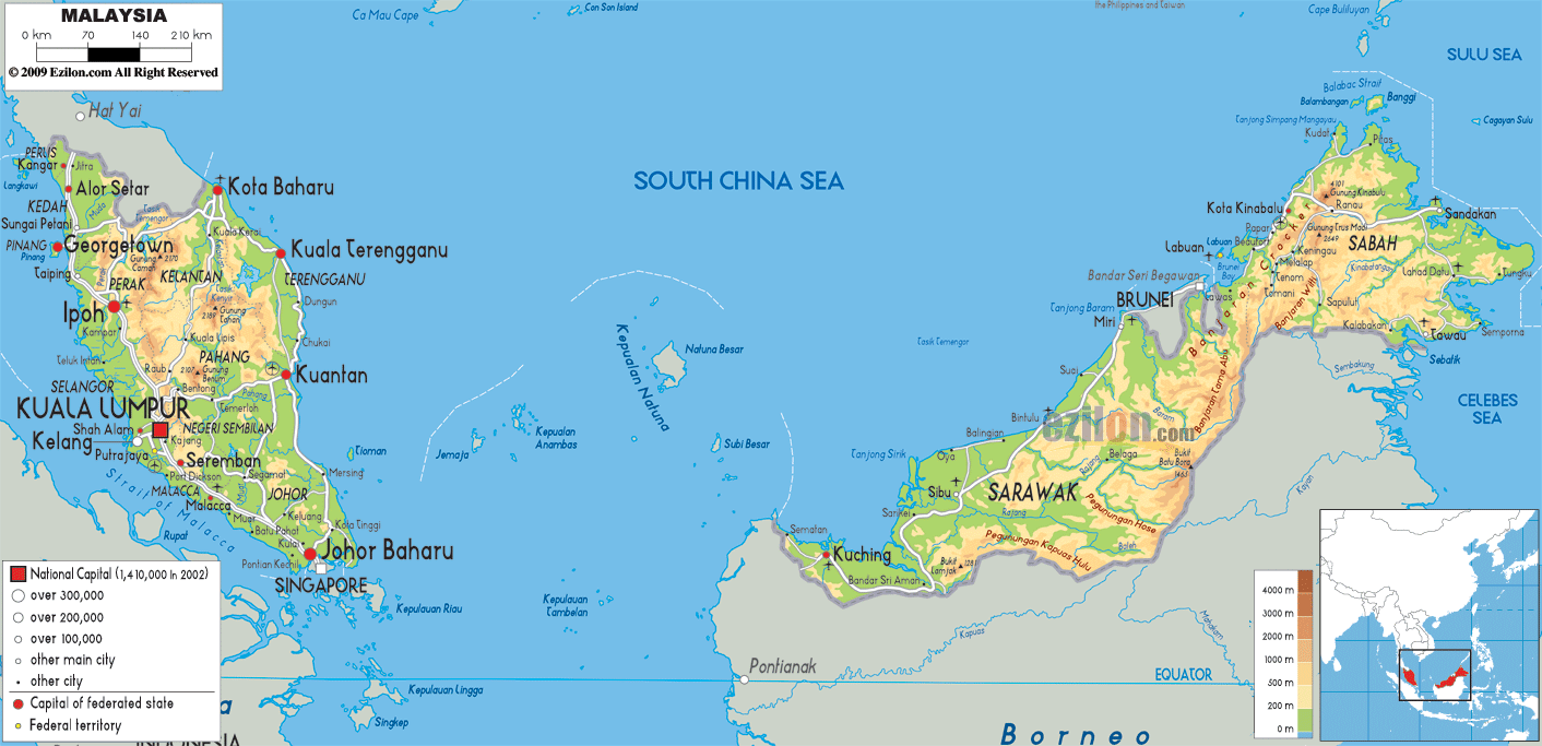
Description: The Physical Map of Malaysia showing major geographical features like elevations, mountain ranges, deserts, seas, lakes, plateaus, peninsulas, rivers, plains, landforms and other topographic features.
This map of Malaysia with mountains, hills, lakes, rivers and other terrains is already large enough to read directly on your desktop. To see a full-screen zoom view on a phone or tablet, tap the map image (or tap the Zoom Map label above the image). Scan by shading states in various colored blocks, with Malaysia's mountains, hills, lakes and rivers in bold.
 Detailed Physical map of Malaysia showing rainforest, mountains and coastline, elevations and other topographic features. Malaysia shares borders with Thailand, Indonesia and Brunei, and is connected to Singapore by a causeway. Malaysia is
divided into two parts by the South China Sea- East
Malaysia and Peninsular Malaysia. East Malaysia has land
and water boundaries with Indonesia and Brunei and only
water boundary withPhilippines.
Detailed Physical map of Malaysia showing rainforest, mountains and coastline, elevations and other topographic features. Malaysia shares borders with Thailand, Indonesia and Brunei, and is connected to Singapore by a causeway. Malaysia is
divided into two parts by the South China Sea- East
Malaysia and Peninsular Malaysia. East Malaysia has land
and water boundaries with Indonesia and Brunei and only
water boundary withPhilippines.
The peninsular Malaysia has land and water boundaries
with Thailand and only water boundary with Vietnam,
Singapore and Indonesia. TanjungPiai which is in
Malaysia is the southernmost tip of continent Eurasia.
The coastal plains have hilly and mountainous regions.
Forty per cent of Malaysia is the peninsular part which
runs 740 kilometres from north to south and is divided
by Titiwangsa Mountains from in between. The mountain
ranges are densely covered by forests and are made of
igneous and granite rocks.
East Malaysia is situated on the Borneo Islands and are
comprised of mountains, hills, valleys and coastal
plains. Mount Kinabalu at 4,095 metres is the highest
peak in Malaysia. Mulu Caves is also located in Malaysia
which is the largest cave system of the world.

Political Map of Malaysia
Political map and map image of Malaysia.

Road Map of Malaysia
Road map and map image of Malaysia.

Regional Directory of United States of America
Information and guide about United States of America and websites with American topics.

Regional Directory of Europe
Information and guide about Europe and websites with European topics.

Regional Directory of Australia
Information and guide about Australia and websites with Australian topics.
