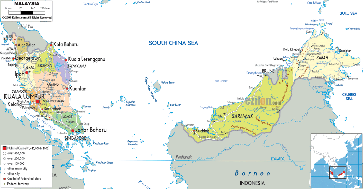
Description: Detailed large political map of Malaysia showing names of capital city, towns, states, provinces and boundaries with neighbouring countries.
This map of Malaysia with cities, states, and towns is already large enough to read directly on your desktop. To see a full-screen zoom view on a phone or tablet, tap the map image (or tap the Zoom Map label above the image). Scan by shading states in various colored blocks, with Malaysia's cities and towns in bold.
Detailed map of Malaysia with cities, towns, states, villages and surrounding countries. Malaysia shares borders with Thailand, Indonesia and Brunei, and is connected to Singapore by a causeway. Color shading and borders separate each of the nation's 13 states and 3 federal territories.
Due to the map's focus on political boundaries, place names, and transport lines, it is one of the best maps for understanding how Malaysia is organized, where its major cities are located, and how the two main regions relate across the South China Sea.
The map of Malaysia with cities shows major cities in Peninsular Malaysia. In addition, it has Kuala Lumpur, Shah Alam, Johor Bahru, George Town, Ipoh, Kota Bharu, Kuantan, Seremban, Malacca City, etc. Kuching, Miri, and Sibu in Sarawak, and Kota Kinabalu in Sabah, are also featured.
A legend features symbols for the National Capital, which is Putrajaya. Furthermore, it also features the state capitals, large cities of more than 300,000 people, other main cities, and smaller towns. Thus, anyone with a map of Malaysia with towns and villages can easily recognize this urban hierarchy.
On the boundaries, the map lists the names of surrounding territories and their bordering seas, including Thailand, Singapore, Indonesia, Brunei, the South China Sea, the Sulu Sea, and the Celebes Sea. All these give MBBS students in the Philippines a regional backdrop.
This map of Malaysia, with regions and colors, shows that Malaysia is a federal constitutional monarchy comprising 13 states (negeri) and 3 federal territories. The Sultans of Kedah, Kelantan, Terengganu, Pahang, Johor, Negri Sembilan, and Selangor, together with the Governor of Penang and the Raja of Perak, and the Crowned Head of Malacca, exercise a limited expression of sovereignty over a certain area within the territories of Malaysia.
According to the map of Malaysia, cities in the federal territories mentioned above include Kuala Lumpur, Putrajaya, and Labuan. Kuala Lumpur is the national capital, while Putrajaya is the federal administrative center. Labuan is a federal territory located off the coast of Sabah.
The map of Malaysia cities, including the capital, Kuala Lumpur, is marked with a special symbol indicating that it is the national capital and a major metropolitan area. The capital of Malaysia is located within the state of Selangor on the western side of the peninsula.
This map, which identifies neighboring towns such as Petaling Jaya, Shah Alam, Klang, and Putrajaya, shows how the Klang Valley has become Malaysia's biggest urban agglomeration. This central cluster assists users of the map of Malaysia by showing cities and towns and explaining how highways and railways radiate from the capital to the peninsula areas.
The map of Malaysia with cities and regions shows Perlis, the smallest state on the peninsula, which borders Thailand. Its capital, Kangar, is marked as the main town. Alor Setar, the capital of Kedah, lies to the south.
Other towns, such as Sungai Petani and Kulim, are marked along the main roads. On the northwest coast, the island state of Penang shows up. George Town is one of Malaysia's important port cities. The UNESCO-listed historic center is marked as the chief city on the Malaysia map cities layer.
The large state of Perak, with its capital Ipoh, and towns such as Taiping, Teluk Intan, and Lumut, is shown across its interior and coastline. The map of Malaysia with towns and villages takes you north to Kangar and Alor Setar, then travels along George Town to Ipoh, which serves as the main travel route between Thailand and the Central West Coast of Malaysia.
As we travel south along the west coast, the Malaysia map with cities shows the highly populated state of Selangor, which surrounds the federal territories of Kuala Lumpur and Putrajaya.
On the map, Shah Alam is indicated as the state capital of Selangor. At the same time, Kuala Lumpur is marked as the national capital and largest city, and Putrajaya is indicated slightly to the south as the purpose-built administrative center.
The Malaysia map cities layer reveals a web of roads and rail lines connecting major towns in the region. Klang, Kajang, Rawang, and Port Klang are the other important towns of this region.
Further south, the state of Negeri Sembilan is shown, with its capital, Seremban, as well as the towns of Nilai, Port Dickson, and Bahau. This displays how the state stretches from the central highlands to the coast.
This map of Malaysia, with cities and towns, shows how the Kuala Lumpur metropolitan area merges into neighboring states along the principal north-south transport corridor for residents and travelers.
Further down the peninsula, the map of Malaysia with states shows the historic state of Malacca (Melaka). Malacca City is the capital and a major port town on the Straits of Malacca. Students of local government or those planning a road trip can benefit from the smaller circles for Alor Gajah and Jasin. Located south of Malacca, the expansive state of Johor constitutes the southernmost portion of Peninsular Malaysia, with its capital, Johor Bahru, opposite Singapore across the Johor Strait.
The layer Johor, Malaysia, map cities above shows Batu Pahat, Muar, Kluang, and Kota Tinggi, all located along major roads linking the interior to the coast and at border crossings. The map of Malaysia with towns and villages labeled will be ordered to show how Johor functions as the gateway between these two countries and how the major roads loop around the coast and the interior of Johor.
The eastern coast of Peninsular Malaysia is home to the states of Kelantan, Terengganu, and Pahang, facing the South China Sea. In Kelantan, the capital city, Kota Bharu, is considered the main city next to the Thai border, while nearby towns Tumpat and Pasir Mas are labeled. To the south, Terengganu is marked out, with Kuala Terengganu as its capital, while the coastal towns of Dungun and Kemaman appear.
You will see the capital city of Pahang, Kuantan, on the east coast, while the further inland towns of Temerloh, Jerantut, and Bentong are shown on the road networks. It occupies most of the central stretches of Peninsular Malaysia.
The east coast states of Malaysia, with cities and regions, are illustrated on the map. The East Coast states are shown to be lined up along the sea. However, the states are connected to the west via highways through the interior to Kuala Lumpur and other west coast cities.
A little over the South China Sea on the right side of the Map of Malaysia, with regions, East Malaysia is located on the island of Borneo, divided into the states of Sabah and Sarawak, and the federal territory of Labuan. The capital, Kota Kinabalu, is an important highlight on the northwest coast of Sabah.
Other major towns such as Sandakan, Tawau, Lahad Datu, and Keningau are labeled around the state. The map of Malaysia shows the island of Labuan off the coast of Sabah. The main town, Victoria, is designated as a federal territory. Also, it is an offshore financial center.
Further to the southwest, the great state of Sarawak is shown, with its capital, Kuching, while other major urban centers, such as Sibu, Bintulu, and Miri, are marked on the coast and on inland rivers. On this map of East Malaysia, with towns and villages, Malaysian Borneo shares land borders with Brunei and Indonesian Kalimantan. Its cities are arranged like a chain along the island's northern coast.
A glance at the map of Malaysia will take you from the north of the peninsula down to the south, through Kangar and Alor Setar, George Town, Ipoh, Kuala Lumpur, Seremban, Malacca City, and Johor Bahru. The main highway corridor, in fact, links all these cities. The Johor Bahru map indicated connections to Singapore and up the east coast via Kota Tinggi, Mersing, and Kuantan, on to Kuala Terengganu and Kota Bahru. This visual travelogue helps users appreciate how the West Coast and East Coast routes form a loop around Peninsular Malaysia on the Malaysia map cities layer.
You make a second mental journey across the map of Malaysia, from towns and villages in the South China Sea to East Malaysia. Imagine traveling from Kuching in Sarawak along the coastal road to Sibu, Bintulu, and Miri, then crossing into Sabah to reach Kota Kinabalu, Sandakan, and Tawau. While not every local street is illustrated on the map, the alignment of major cities and towns provides a clear indication of regional corridors suitable for planning flights, bus trips, and overland trips.
Malaysia's map, with cities and regions, further puts the country into perspective within its international environment. An easily identifiable label is used on Peninsular Malaysia's northern land border with Thailand, and on the causeways and bridges connecting Peninsular Malaysia to Singapore at the southern tip. East Malaysia has a land border with Kalimantan, Indonesia, and completely encircles the tiny country of Brunei, which lies between Sarawak and Sabah.
The surrounding seas are the South China Sea, which separates the peninsula from Borneo; the Strait of Malacca, off the west coast; and the Sulu Sea and Celebes Sea, off Sabah. The labels on the map of Malaysian cities and towns are useful for users who search for them when planning cruises or ferry routes that will be affected by shipping limits.
This political Map of Malaysia with towns and villages is flanked by a legend which helps us understand its intricate details. For instance, the different sizes of the symbols show urban hierarchy. Therefore, the national capital is shown with a larger symbol, compared to smaller towns, which are shown with smaller symbols.
The most important symbol has been assigned to Kuala Lumpur because it's the capital and the largest city of Malaysia. Similarly, other cities like George Town, Johor Bahru, Kota Bharu, Kota Kinabalu, Kuching, Ipoh, and Kuantan use a large circle to signify a population of several hundred thousand. To represent the various local communities in Malaysia's states and federal territories, secondary cities and district towns are shown with diminishing circles or dots.
The service center hierarchy on the Malaysia map cities layer helps your residents see where major service centers are located relative to their hometowns. Investors are to evaluate which centers have the potential to become regional hubs—students of urban geography and the distribution of population over Peninsular and East Road.
The Map of Malaysia with cities and towns will be useful to different users as it incorporates political boundaries, major cities, smaller towns, roads, borders, and the surrounding seas. With this app, residents can find their state and district, learn the state's capital, and see how highways and rail links connect them to Kuala Lumpur, Penang, Johor Bahru, or Kuching.
Tourists can devise routes with travel patterns like Kuala Lumpur-George Town-Langkawi via Kedah, Malacca City, Johor Bahru, and Kota Kinabalu, as well as to the cities of Sarawak. The cities act as labels for both domestic and cross-border journeys.
The map of Malaysia with regions helps geography students get a clear visual summary of the federation. It describes the distribution of the two landmasses – main and east Malaysia, as well as how Malaysia interacts with its neighboring nations. Because this political map doesn't include physical features – mountains, rivers, and, for that matter, anything else- it keeps the focus on human geography topics such as federalism, urbanization, transport corridors, and border relations. These lessons can then be added to with physical maps.
Malaysia is located in Southeast Asia between Thailand, Singapore, Indonesia, and Brunei.
The map shows Peninsular Malaysia in the west and East Malaysia on the island of Borneo.
The political map shows 13 states and 3 federal territories across Malaysia.
Kuala Lumpur is shown as the national capital and largest metropolitan area in Malaysia.
Putrajaya is shown as Malaysia's federal administrative center south of Kuala Lumpur.
Neighboring countries shown include Thailand, Singapore, Indonesia, and Brunei.
The map shows the South China Sea, Strait of Malacca, Sulu Sea, and Celebes Sea.
Major cities shown include Kuala Lumpur, George Town, Johor Bahru, Ipoh, Kota Bharu, Kuantan, Kuching, Kota Kinabalu, and Malacca City.
Kuala Lumpur is located on the western side of Peninsular Malaysia within the Klang Valley region.
Cities surrounding Kuala Lumpur include Petaling Jaya, Shah Alam, Klang, Kajang, and Putrajaya.
The Klang Valley is important because it forms Malaysia’s largest urban and economic corridor.
Northern states shown include Perlis, Kedah, Penang, and Perak.
Kangar is located in Perlis near Malaysia's northern border with Thailand.
Cities shown in Kedah include Alor Setar, Sungai Petani, and Kulim.
George Town is located on Penang Island along Malaysia's northwest coast.
Perak cities shown include Ipoh, Taiping, Teluk Intan, and Lumut.
Central west coast states shown include Selangor and Negeri Sembilan along with the federal territories.
Shah Alam is located in Selangor west of Kuala Lumpur.
Negeri Sembilan towns shown include Seremban, Nilai, Port Dickson, and Bahau.
Southern states shown include Malacca and Johor.
Malacca City is located along the Strait of Malacca on the southwestern coast of Peninsular Malaysia.
Johor Bahru is located at the southern tip of Peninsular Malaysia opposite Singapore.
Johor towns shown include Batu Pahat, Muar, Kluang, Kota Tinggi, and Mersing.
East coast states shown include Kelantan, Terengganu, and Pahang.
Cities shown include Kota Bharu, Tumpat, Pasir Mas, Kuala Terengganu, Dungun, and Kemaman.
Pahang towns shown include Kuantan, Temerloh, Jerantut, and Bentong.
East Malaysia states shown include Sabah and Sarawak along with the federal territory of Labuan.
Cities shown include Kota Kinabalu, Sandakan, Tawau, Kuching, Sibu, Bintulu, and Miri.
The map highlights major north-south corridors linking Kuala Lumpur, George Town, Malacca City, Johor Bahru, Kuantan, and East Malaysian coastal cities.
No. Printing or copying maps from this site is not permitted.

Physical Map of Malaysia
Physical map and map image of Malaysia.

Road Map of Malaysia
Road map and map image of Malaysia.

Regional Directory of United States of America
Information and guide about United States of America and websites with American topics.

Regional Directory of Europe
Information and guide about Europe and websites with European topics.

Regional Directory of Australia
Information and guide about Australia and websites with Australian topics.