Description: Detailed large political map of India showing names of capital city, towns, states, provinces and boundaries with neighbouring countries.

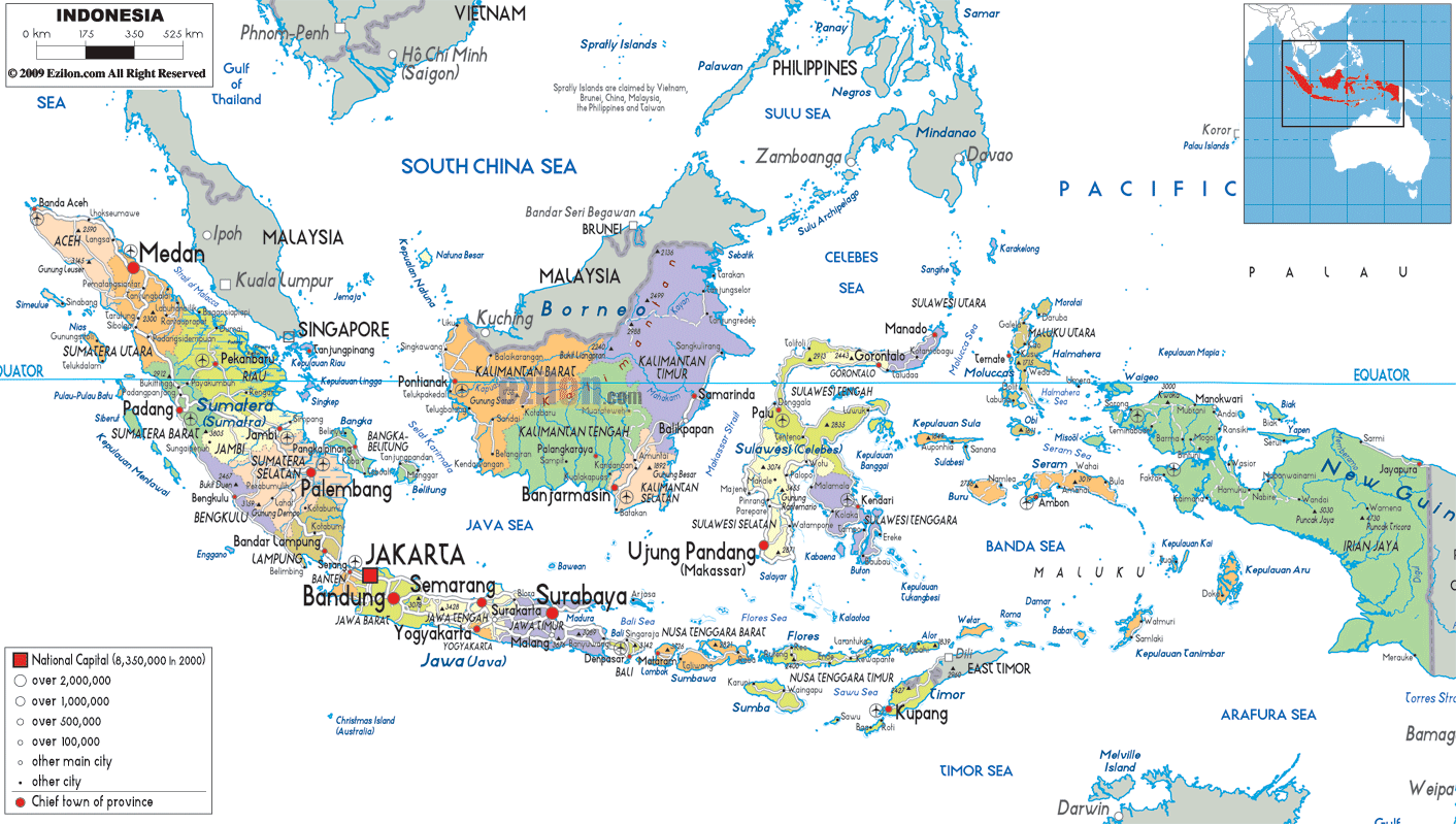
The map of Indonesia, the Indonesia map with cities, towns, and regions, and what you see on the political map all imply the same thing when you look closer. Indonesia's cadastral map shows the country's various islands in different colors. An administrative map of Indonesia shows the provinces, capital towns, and major cities of Sumatra, Java, Kalimantan, Sulawesi, the Lesser Sunda Islands, and Papua.
Most notably, the country's outline is depicted in blue. In addition, these features with clear demarcation are helpful for travelers, students, and citizens alike who wish to learn about the country. Moreover, they are handy tools for learning about a nation, its culture, and geographical and political features.
At the highest level, the Indonesia map on this page shows Indonesia divided into 38 provinces, including several with special autonomous status. Different colors on the map have been used to shade each province. The provincial boundaries have been drawn around groups of islands or portions of larger islands, such as Sumatra, Borneo (Kalimantan), and New Guinea (Papua).
The map shows different-colored areas; each represents a province, and dots and symbols show provincial capitals and other cities. Big cities in Indonesia, such as Jakarta, Surabaya, Bandung, and Medan, are depicted with large circles, while smaller circles represent smaller towns and local centers.
The map of Indonesia, with cities and regions, also shows neighboring countries and the seas surrounding Indonesia. These include Malaysia, Singapore, the Philippines, Vietnam, Papua New Guinea, and Timor Leste, which are labeled along with the South China Sea, Java Sea, Banda Sea, Celebes Sea, Arafura Sea, and Indian Ocean.
Stretching from the Indian Ocean to the Pacific, Indonesia is the world's largest archipelago by number of islands. In this regional context, Indonesia is the largest island nation in the world, both in land area and population. Because the map's legend explains what each symbol or color represents, readers can easily distinguish the national capitals, provincial capitals, major cities, other towns, and provincial boundaries. This is among the best map formats for teaching the basics of Indonesia's political geography.
When you start following the Indonesian map of the island of Java, you will immediately see the dense cluster of many names and cities. Indonesia's national capital, Jakarta, is located on the northwestern coast of Java. Its symbol and label are larger than those of the two other towns, both nearby and far away.
The nearby cities of Bekasi, Depok, Tangerang, Bogor, and others form a metropolis ring that encircles Jakarta. Thus, these regions are among the most densely populated cities in the world.
Moving eastwards on Java, we see other major cities such as Bandung in West Java, Semarang in Central Java, Yogyakarta, a special region, and Surabaya in East Java, each shown as an important node on this map of cities in Indonesia.
The provincial capitals are connected by lines, with Cirebon, Tegal, Solo (Surakarta), Malang, Jember, etc. appearing as smaller dots between the lines, representing the main transport routes of the island. The map of Indonesia shows the cities of Java.
These cities, along with many others, line the northern and southern coasts and the interior of Java. Consequently, it is easy to imagine a road or rail journey from Jakarta to Surabaya. Similarly, we can imagine the journey from Bandung to Yogyakarta.
This map of Indonesia, with cities and regions, depicts the long island of Sumatra, located west of Java, divided into several provinces from north to south. These provinces include Aceh, North Sumatra, West Sumatra, Riau, Jambi, South Sumatra, Bengkulu, and Lampung.
Nanggroe Aceh Darussalam has Banda Aceh as its capital and other towns along the coast, such as Lhokseumawe at the northern tip. Located to the south of Aceh, the North Sumatra province of Indonesia is marked by Medan. As one of Indonesia's major cities, Medan serves as a major symbol and gateway to this island.
West Sumatra, Riau, Jambi, South Sumatra, Bengkulu, and Lampung provinces are shaded separately (Sumatra, Indonesia). Their provincial capitals or major cities are Padang, Pekanbaru, Jambi, Palembang, and Bandar Lampung, respectively.
This map of Indonesia with towns will give users an idea of the locations of local administrative and commercial centers. It also has smaller towns along the coast and in the interior. Due to the island's proximity to Malaysia and Singapore, the map shows that Sumatra's northern and eastern edges face the Malacca Strait and the South China Sea.
In the Map of Indonesia with cities, occupying much of the center of the area is the enormous landmass of Borneo, which is shared with Malaysia and Brunei, and is divided into many provinces, together known as Kalimantan.
The map shows the names of provinces, including West Kalimantan, Central Kalimantan, South Kalimantan, East Kalimantan, and North Kalimantan, along with their provincial centers: Pontianak, Palangkaraya, Banjarmasin, Samarinda, and Tanjung Selor. The political map, which emphasizes human settlements over physical features, indicates that these provincial capitals form important nodes amid the forests and rivers, which are not shown.
In the Kalimantan area, the map of Indonesian cities also displays the international borders with Malaysia and Brunei, as well as the South China Sea and Java Sea, to highlight how Indonesia's Borneo provinces are connected to neighboring countries and the ocean. This part of the map shows how one island is divided among three countries (for geography students), while for residents and travelers, it shows the main urban centers in Kalimantan, Indonesia.
Towards the east, the map of Indonesia with towns shows Sulawesi's distinct four-armed shape with its four provinces, such as North Sulawesi, Central Sulawesi, South Sulawesi, Southeast Sulawesi, and Gorontalo.
Manado, Palu, Makassar (Ujung Pandang), and Kendari are among the larger cities, marked by larger symbols, and the smaller coastal and inland towns are more scattered along the island's complex coastline. The map shows the names of each province's capital city in Sulawesi.
Moving further east and south, we see the cities and regions map of Indonesia showing provinces throughout the Maluku and Nusa Tenggara island chain, covering Maluku, North Maluku, West Nusa Tenggara, and East Nusa Tenggara.
Places like Ambon, Ternate, Kupang, and Mataram appear as capital or major towns, and various minor islands are labeled with town names to show where local people congregate. If you want to travel to eastern Indonesia, this map will help you understand which islands have provincial capitals and which smaller islands have only a town or two.
On the Map of Indonesia with regions, the far right side shows Papua and its neighboring provinces. These take up the western half of New Guinea and the surrounding islands. Administrative reforms recently introduced in this area have created several provinces, including Papua, West Papua, South Papua, Central Papua, Highland Papua, and Southwest Papua.
Major towns include Jayapura, Manokwari, Sorong, Merauke, Nabire, and Wamena, which serve as administrative centers and are largely coastal, making access easier.
The Indonesian map also shows that the eastern part of the province faces Papua New Guinea to the east and the Arafura Sea to the south. Therefore, this can help the residents and the students visualize Indonesia's eastern provinces.
Because this region is large and sparsely populated, the map of Indonesia with towns and villages is particularly useful for seeing where communities and administrative centers are in the grander scheme of things.
In the second part of our tour, imagine tracing the Map of Indonesia with cities and towns along its main population corridors. Starting in the northern city of Medan on Sumatra, you can see how cities and towns align down the island's eastern side, connecting through Pekanbaru, Jambi, Palembang, and Bandar Lampung before crossing toward Jakarta in Java. Light lines on the map represent the main roads and transport routes linking these urban centers, showing the long chain of settlements along Sumatra's coast.
On Java, the same map with cities reveals a dense web of cities and towns that stretches from Jakarta through Bandung, Cirebon, Semarang, and Surabaya, with additional names indicating satellite cities and regency seats that fill in the spaces between major metropolitan areas. Residents planning trips can use this pattern to estimate distances and likely travel paths. At the same time, geography students see a practical example of how an island with rich urban development is structured politically and administratively.
The map of Indonesia is carefully labeled with cities, regions, neighboring countries, and more. It brings all the aspects of this country. So that one can better understand Indonesia and its neighboring states. To the north and northwest, the countries of Malaysia, Singapore, Thailand, and Vietnam are evident. Further towards the northeast, you find the Philippines. Papua New Guinea lies to the east. And finally, to the south, Australia and Timor-Leste are clearly written. As shown on the map of Indonesia, the country lies on key maritime routes in the Indian and Pacific Oceans. It also shares land borders with Borneo, New Guinea, and Timor.
A lot of online searches relating to the queries' map of Indonesia city' and 'map of Indonesia with region' are related to travel and trade questions, and the names of neighboring countries and surrounding seas add a lot of value to this detailed map for planning cross-border movement and regional groupings like ASEAN.
This political map of Indonesia with towns uses symbol size to represent the hierarchy of the cities. The biggest circle is the national capital, Jakarta. On the other hand, major cities such as Surabaya, Bandung, Medan, Makassar, Semarang, and Denpasar are shown with slightly smaller circles. These cities are generally the capital or a large metropolitan city. The circles below are little towns and local headquarters. 'Small towns' do not disappear from the map.
The map's visual structure makes it easier for geography students to recognize which cities are more important in a province. Residents and travelers can easily identify the nearest large urban center for services, transportation, and business.
The Indonesian map of cities and towns is a multifunctional map that combines provinces, cities, towns, border labels, and the surrounding ocean. Residents can identify their home province and nearby provincial capitals, such as Bandung, Palembang, Pontianak, Manado, or Jayapura, and how their local town fits into the National and Regional Pattern Administration.
Tourists can use a map of Indonesia with cities to plan their holiday itinerary. They can hop from one major city to another, like Jakarta, Yogyakarta, Bali, Lombok, Makassar, and Raja Ampat. You can remember intermediate cities. In some cases, they may end up staying at transit cities. The intermediate cities can also be ferry ports or overnight stops.
An Indonesian map with regions makes it easier for geography students. For information, there are 38 provinces spread over 17,000 islands. This makes controlling a large archipelago country difficult. The fact that the map is political and does not indicate physical relief makes it easier for one to discuss various matters. For instance, they can discuss matters such as regional autonomy, population distribution, and administrative divisions without being distracted by terrain details.
Indonesia is located between the Indian Ocean and Pacific Ocean in Southeast Asia.
The political map shows Indonesia divided into 38 provinces.
Jakarta is shown as the national capital on the northwestern coast of Java.
Major cities shown include Jakarta, Surabaya, Bandung, Medan, Makassar, Semarang, Denpasar, and Jayapura.
The map shows Sumatra, Java, Kalimantan, Sulawesi, Papua, Maluku, and the Lesser Sunda Islands.
Jakarta is located on the northwestern coast of Java Island.
Cities surrounding Jakarta include Bekasi, Depok, Tangerang, and Bogor.
Bandung is located in West Java southeast of Jakarta.
Major cities on Java include Jakarta, Bandung, Semarang, Yogyakarta, and Surabaya.
Light road and rail corridors connect Jakarta, Bandung, Cirebon, Semarang, Yogyakarta, and Surabaya.
Sumatra is located west of Java along the Malacca Strait and Indian Ocean.
Cities shown on Sumatra include Banda Aceh, Medan, Padang, Pekanbaru, Jambi, Palembang, and Bandar Lampung.
Medan is located in North Sumatra near the northeastern coast of Sumatra.
Sumatra provinces shown include Aceh, North Sumatra, West Sumatra, Riau, Jambi, South Sumatra, Bengkulu, and Lampung.
Kalimantan occupies the Indonesian portion of Borneo in the central-northern area of the map.
The map shows West Kalimantan, Central Kalimantan, South Kalimantan, East Kalimantan, and North Kalimantan.
Cities shown include Pontianak, Palangkaraya, Banjarmasin, Samarinda, and Tanjung Selor.
Malaysia and Brunei border the Kalimantan region on Borneo Island.
Sulawesi is located east of Kalimantan with its distinctive multi-peninsula shape.
Cities shown include Manado, Palu, Makassar, Gorontalo, and Kendari.
Papua is located on the eastern side of Indonesia on the western half of New Guinea.
Papua cities shown include Jayapura, Sorong, Manokwari, Merauke, Nabire, and Wamena.
Papua New Guinea borders Indonesia on the eastern side of Papua.
Cities shown include Denpasar, Mataram, and Kupang.
The map shows the South China Sea, Java Sea, Banda Sea, Celebes Sea, Arafura Sea, and Indian Ocean.
Neighboring countries shown include Malaysia, Singapore, the Philippines, Vietnam, Papua New Guinea, and Timor-Leste.
Yes, the map clearly displays provincial boundaries and regional divisions.
Yes, the map is useful for studying provinces, cities, islands, and political geography.
Yes, travelers can use the map to understand ferry routes, islands, cities, and regional travel corridors.
No. Printing or copying maps from this site is not permitted.

Physical Map of Indonesia
Physical map and map image of Indonesia.

Road Map of Indonesia
Road map and map image of Indonesia.

Regional Directory of United States of America
Information and guide about United States of America and websites with American topics.

Regional Directory of Europe
Information and guide about Europe and websites with European topics.

Regional Directory of Australia
Information and guide about Australia and websites with Australian topics.