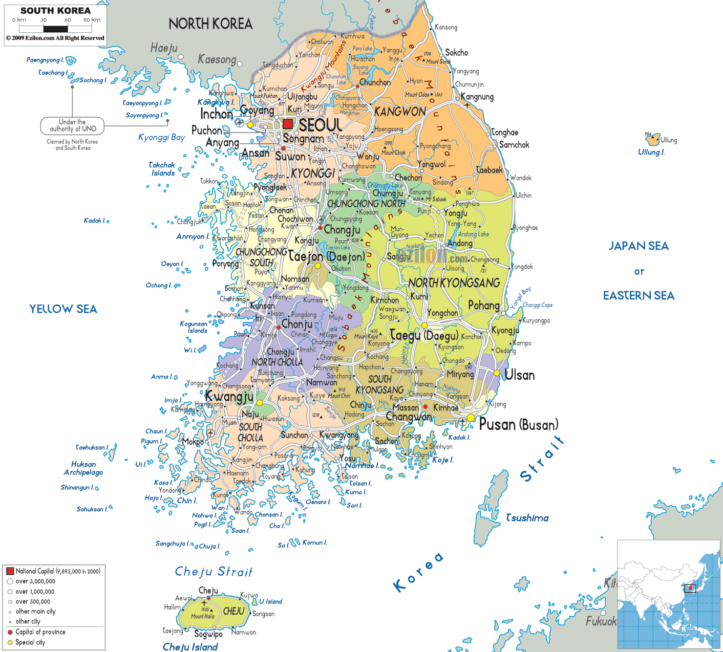
Description: Detailed large political map of South Korea showing names of capital city, towns, states, provinces and boundaries with neighbouring countries.
This map of South Korea with cities, provinces, and towns is already large enough to read directly on your desktop. To see a full-screen zoom view on a phone or tablet, tap the map image (or tap the Zoom Map label above the image). Scan by shading provinces in various colored blocks, with South Korea's cities and towns in bold.

Detailed map of South Korea with cities, towns, provinces, villages and surrounding countries. South Korea's only land neighbor is North Korea, separated by the Demilitarized Zone (DMZ) to the north. Because the area is too small, the northern part of Korea is not visible. The map outlines the provinces and provincial-level cities of Korea. It also points out national, provincial, and local urban centers. From Seoul to Busan, each city (or town) is carefully demarcated. This includes small county towns as well.
South Korea Map – Most Accurate Map Styles: Because the design focuses on administrative boundaries, city names, coastal labels, and neighboring countries rather than terrain, it is one of the most useful map styles for understanding how South Korea is organized and how its people and services are distributed.
This map of South Korea, with regions, shows the country divided into several types of first-level civil units. There is one special city, namely Seoul; several metropolitan cities such as Busan, Daegu, Incheon, Gwangju, Daejeon, and Ulsan; one special self-governing city, namely Sejong; and nine provinces, including Gyeonggi, Gangwon, North Chungcheong, South Chungcheong, North Jeolla, South Jeolla, North Gyeongsang, South Gyeongsang, and Jeju Special Self-Governing Province. The different provinces or cities are shown in unique colors and boundary markings, which help you see their shape and coverage.
The South Korea map, with cities arranged in a hierarchy of circles, illustrates city sizes within the colored areas. The national capital has its own symbol, while large circles highlight cities that reach a certain population size, smaller circles depict other major cities and local towns.
The waters around the peninsula are labeled on the map as the Yellow Sea, the Korea Strait, and the Sea of Japan, and the northern edge is labeled North Korea. At the same time, South Korea's place within East Asia, viz-a-viz China and Japan, is shown as a small inset.
Seoul is in the northwestern part of the peninsula. The map of South Korean cities identifies each city with a symbol representing the national capital. Also, over 9 million people live in this city. Gyeonggi Province surrounds Seoul. This province includes several satellite cities near Seoul. Furthermore, these cities include Incheon, Suwon, Goyang, Seongnam, Anyang, and Bucheon. Moreover, they are clearly labeled and form the wider capital region.
The map illustrates this tightly packed agglomeration of cities in the lower reaches of the Han River; the capital region is the most densely populated part of the country.
Being a major port and home to the country's main international airport, Incheon is prominently located to the west of Seoul. At the same time, Suwon is designated as Gyeonggi Province's capital.
The section of the map of South Korea showing towns and villages makes it clear to residents where the special city of Seoul ends, and the province begins. For travelers, it helps you quickly orient yourself to how close together Seoul, Incheon, and neighboring Gyeonggi cities are.
The provinces of North Chungcheong and South Chungcheong are north and south of Seoul. The Map of South Korea with cities and regions shows these in different colors.
Cheongju, the provincial capital of North Chungcheong; Hongseong, the capital of South Chungcheong; and the metropolitan city of Daejeon are near major cities and science cities. Smaller cities like Chungju, Jecheon, Cheonan, and Asan appear as small dots connected by light road lines, indicating the main routes running through central South Korea.
The South Korea map cities layer can be used across the provinces to show how population spreads between the mountains and the coasts, not just along the coast. For students of geography, the way provincial boundaries encircle Daejeon and extend to the Yellow Sea and the East Sea shows how central Korea serves as a junction.
The South Korea with towns map also shows North Jeolla (Jeollabuk-do) and South Jeolla (Jeollanam-do) extending along the Yellow Sea coast on the peninsula's southwestern side, enclosing many offshore islands.
The provincial capitals Jeonju in North Jeolla and Muan in South Jeolla are shown. At the same time, the large metropolitan city of Gwangju is designated as a major urban node in southern Jeolla. The irregular coastline and island chains are shown as dots for smaller coastal cities and ports such as Mokpo, Yeosu, Gunsan, and Suncheon.
This South Korea map shows how the seafaring agricultural communities of the area are linked by ferry and road with coastal speedsters and inland cities like Gwangju. Students of geography might note that the Jeolla provinces constitute a distinct southwestern cultural and political region of South Korea, despite the country's regional administrative system.
The Map of South Korea with towns and villages shows, on its eastern side, North Gyeongsang (Gyeongsangbuk-do) and South Gyeongsang (Gyeongsangnam-do), which run along the East Sea and the Korea Strait.
Within this region, the inland city of Daegu serves as the metropolitan center, while Busan (Pusan), at the southeastern tip, is the country's second-largest city and main port. The coast also features other cities, such as Ulsan, Pohang, Changwon, and Tongyeong, as well as smaller towns in between.
Many search for a map of South Korea cities to get an idea of where Busan and Daegu are, in relation to Seoul, which is why this section of the map is important. The provincial borders and city names also indicate the industrial axis along the southeastern coast, critical to South Korea's manufacturing and shipping economy.
Northeast of Seoul, the map of South Korea with regions has the province of Gangwon stretching from the Demilitarized Zone in the North to the East Sea. Also, the cities of Chuncheon, Gangneung, and Sokcho are regional centers. Although many large cities appear here, many smaller towns and counties are also indicated, reflecting the province's more rural nature. The South Korea map with cities and towns shows that even a province with tricky terrain has a host of coastal and inland towns linked to the national road and rail network.
Off the southern coast, the map of South Korea with cities and regions features Jeju Special Self-Governing Province, known as Jeju Island. The island is marked by its provincial capital, Jeju City, in the North and Seogwipo on the southern coast, with lesser-known localities scattered around the island.
The South Korea map cities layer includes Jeju as an important destination for domestic and international tourism. This function shows users where the island is located relative to other key ports on the mainland, such as Busan, as well as coastal towns in South Jeolla.
Imagine moving along the map of South Korea, from North to South, from city to town. Upon approaching the Demilitarised Zone, one sees the label' North Korea' inscribed above the border towns of Kaesong on the northern side of the line and the South Korean localities of Paju and Yeoncheon just below it. Further south, the urban area around Seoul appears almost immediately. The capital occupies one-fourth of the whole area. In turn, a dense cluster of names develops in Incheon, Goyang, Bucheon, Seongnam, Suwon, and Ansan.
You continue to follow the web of road lines from the capital region through Daejeon and Cheongju towards the center, then east to Daegu and Pohang, or west towards Jeonju and Gwangju.
Busan, Ulsan, Changwon, Yeosu, and Mokpo are dominant port cities, and if you look offshore, you'll see the outline of Jeju Island. This mental map shows how South Korea's cities along corridors linking Seoul and Busan via the west and east coasts are linked through dense transport networks.
The map shows the regional context of South Korea. Furthermore, the map shows nearby seas and countries, as well as other provinces within the country. Above the demilitarized zone is North Korea; to the west lies the Yellow Sea, with China visible across the water. To the southeast is Japan, across the Korea Strait and the Sea of Japan (the Eastern Sea). The labels indicate that South Korea shares a land border with the North but has significant maritime borders with China and Japan.
People who live in or travel to South Korea may find this international framing of interest when looking for a map of South Korea showing cities and towns. It indicates where ports, ferry routes, and international airports connect to the wider region. The information can help students understand lessons on East Asian geopolitics and the strategic significance of the Korean Peninsula.
This political map of South Korea with towns represents the various urban hierarchies through symbols of different sizes. The national capital and largest city, Seoul, has a special symbol. Other large metropolitan cities are Busan, Incheon, Daegu, Daejeon, Gwangju, and Ulsan. There is a large circle that represents them and their population of 1 million. The medium circles are for smaller cities that are provincial/regional hubs. Most small dots are for county seats and rural towns.
The hierarchy allows readers to get a quick dash of major business centers and terminal points on a South Korea map with cities. It also helps geography students understand that population and service concentration occur only in a few large urban agglomerations, leaving smaller towns in the lurch.
This Map of South Korea with cities and towns is perfect for everyone because it includes administrative divisions, city and town names, borders, and seas. Residents can find out their province or metropolitan city, which urban center serves as their provincial capital, and how their local town links to national corridors such as the Seoul-Busan axis. A South Korea map with cities and regions helps travelers plan itineraries for Seoul, Incheon, Daejeon, Daegu, Busan, Gwangju, Jeju, and other towns in between.
The map of South Korea with Regions is ideal for geography students. It provides an overview of the nine provinces, metropolitan cities, and special jurisdictions of South Korea, and their relations with the Yellow Sea, the East Sea, and the Korea Strait. This political map doesn't include elevation or physical geography information. It is great for lessons on human geography (administrative boundaries, urbanization, transportation) before students add their own layers, such as climate or landforms.
South Korea is located on the southern half of the Korean Peninsula in East Asia.
South Korea borders North Korea and is surrounded by the Yellow Sea, Korea Strait, and Sea of Japan.
The political map shows nine provinces along with metropolitan cities and special administrative cities.
Seoul is shown as the national capital and largest urban center in South Korea.
Major cities shown include Seoul, Busan, Incheon, Daegu, Daejeon, Gwangju, Ulsan, and Suwon.
Seoul is located in northwestern South Korea along the Han River near the Yellow Sea coast.
Cities surrounding Seoul include Incheon, Suwon, Goyang, Seongnam, Anyang, Bucheon, and Ansan.
The Seoul capital region is the most densely populated and economically important urban corridor in South Korea.
Incheon is located west of Seoul along the Yellow Sea coast.
The Chungcheong region includes North Chungcheong and South Chungcheong provinces.
Cities shown include Daejeon, Cheongju, Chungju, Jecheon, Cheonan, and Asan.
Daejeon is located in central South Korea between Seoul and Daegu.
The Jeolla region includes North Jeolla and South Jeolla provinces.
Cities shown include Gwangju, Jeonju, Muan, Mokpo, Yeosu, Gunsan, and Suncheon.
Gwangju is located in southwestern South Korea within the Jeolla region.
The Gyeongsang region includes North Gyeongsang and South Gyeongsang provinces.
Cities shown include Busan, Daegu, Ulsan, Pohang, Changwon, and Tongyeong.
Busan is located at the southeastern tip of South Korea along the Korea Strait.
Busan is South Korea's second-largest city and one of the country's most important ports.
Daegu is located inland in southeastern South Korea within the Gyeongsang region.
Cities shown in Gangwon include Chuncheon, Gangneung, and Sokcho.
Gangwon stretches from the Demilitarized Zone to the eastern coastline along the Sea of Japan.
Jeju Island is located south of the Korean Peninsula in the Korea Strait.
Jeju City and Seogwipo are the major cities shown on Jeju Island.
The map highlights the major Seoul-Daejeon-Daegu-Busan transport corridor across the country.
Neighboring countries shown include North Korea, China, and Japan.
Yes, the map clearly displays provinces, metropolitan cities, and administrative boundaries.
Yes, the map helps geography students study urbanization, provinces, transportation corridors, and regional geography.
Yes, travelers can use the map to plan routes between Seoul, Busan, Jeju, and regional cities.
No. Printing or copying maps from this site is not permitted.

Physical Map of South Korea
Physical map and map image of South Korea.

Road Map of South Korea
Road map and map image of South Korea.

Regional Directory of United States of America
Information and guide about United States of America and websites with American topics.

Regional Directory of Europe
Information and guide about Europe and websites with European topics.

Regional Directory of Australia
Information and guide about Australia and websites with Australian topics.
