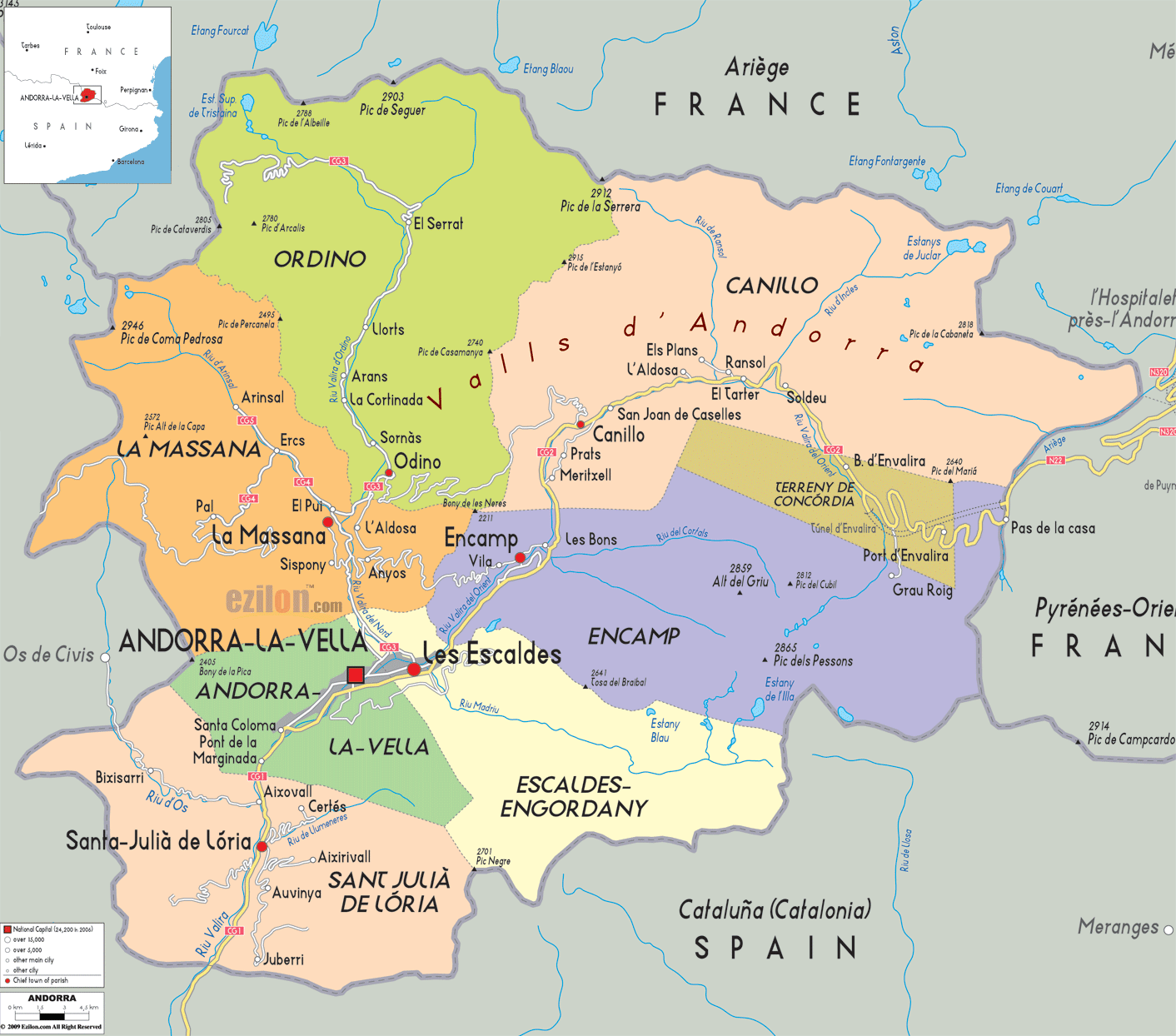
Description: Detailed large political map of Andorra showing names of capital cities, towns, states, provinces and boundaries with neighbouring countries.

Detailed map of Andorra with cities, towns, parishes, villages and surrounding countries. This page is built around a detailed map that shows the entire principality at a glance, bordered by France to the north and Spain to the south. From the northern peaks on the French border to the southern gateway to Spain, every parish, town, resort, and road is clearly drawn so travelers, residents, and geography students can follow the layout in real time. The Andorra map with cities is not just a picture. It is a compact guide to the country's high valleys, ski areas, river system, and border crossings that you can trace with your eyes as you read.
Because Andorra is a small mountain country, a detailed map is the best way to understand how everything fits together. The central valleys run north-south, the road network follows rivers, and towns are where slopes meet basins. The map demonstrates those patterns. You'll be able to tell where the capital, the parish centres, and the major resorts are situated relative to each other, and to France and Spain.
The map shows Andorra nestled in the eastern Pyrenees, between France to the north and Spain to the south. The borders trace the crests of rugged mountains that ring the high valleys of the Valira River system. With an area of about 468 square kilometers, Andorra is one of Europe's smallest countries, yet the map makes clear how densely packed its parishes, towns, and resorts are within that compact space.
On the northern edge of the map, you can see the names of French neighboring areas such as Ariège, while on the southern side, the labels point toward Catalonia in Spain. This gives immediate orientation for anyone arriving by road from Toulouse or Barcelona. The border passes, and tunnels marked on the map show the limited but essential connections that Andorra has with its two large neighbors.
The map uses a shading style and peak labels to show the steepness. The western Pic de Coma Pedrosa and eastern Pic d'Envalira top 2,900 metres, while the valleys get successively narrower between them. The map's placement of towns on valley floors and lower slopes makes it clear why settlements cluster along the rivers and roads rather than on the high ridges.
A primary advantage of this Andorra map with cities is how well it displays the seven parishes, the country's administrative units – Andorra la Vella, Escaldes-Engordany, Sant Julià de Lòria, La Massana, Ordino, Encamp, and Canillo. The individual colors of each parish, along with boundaries drawn along ridgelines and river divides, will immediately show which towns belong together.
At the center-south of the map is Andorra la Vella, the capital and largest urban area, marked clearly as a significant city symbol. Escaldes-Engordany, located directly to the northeast, forms the unbroken built-up strip that most tourists first visit. To the south, we find Sant Julià de Lòria, the parish that reaches to the Spanish border. According to the map on the left, La Massana and Ordino are in the higher valleys. And on the right, Encamp and Canillo lead into the major ski areas and the French border.
By combining parish shading with town names, the map becomes the best map tool for understanding not only where places are, but also how Andorra's government and local identity are organized. Residents can easily see where one parish ends, and another begins, while visitors can plan trips that explore each parish in turn.
Look at the upper left of the map, and you will see the parish of Ordino, colored in a distinct shade and labeled with its main town, Ordino, near the valley floor. More minor settlements, such as El Serrat, Llorts, and Arans, climb up the valley toward the high mountains. The main river in this sector flows southward through the valley, and the road closely follows it, clearly showing how travelers move between the villages.
This detailed map makes it easy to spot the route that continues up toward the Ordino Arcalís ski area, one of the country's key winter sports zones. Peaks and passes close to the French border shape this valley, indicating that the mountains are not only beautiful but also natural boundaries. The map will help the adventure traveler, hiker, and skier to see how close the ski slopes are to each village and how the access road curves up toward the resort.
Further down the Ordino valley, the map shows how the road links back toward La Massana and the central valley. As streams from side valleys flow into the central valley, students of geography will understand tributary valley structures. This is the Vall d'Aran, a basin that dominates the drainage and road network of Andorra. The Andorra map with cities can also be used to teach physical geography by examining how topography affects settlements and communication.
Just south of Ordino on the map lies the parish of La Massana, another key hub for mountain tourism. The town of L Massana is set where several valleys meet, while the map revealed more roads leading west to Pal and Arinsal. People who are in the Pal-Arinsal sector of the Vallnord ski domain are well familiar with these names. The map clearly marks these villages and the valley heads where lifts and slopes begin, so visitors can visualize how to reach the ski areas from the capital or from other parishes.
Following the road lines on the map, you can see that one route climbs from La Massana to Pal, then continues up to the ridge near the Spanish border, while another route leads into the Arinsal valley. This pattern reflects how Andorra uses valley corridors to access high mountain terrain. For residents, the map confirms daily commuting patterns, showing how close La Massana is to Andorra la Vella and how quickly the main road connects to the central urban corridor.
The western edge of the map also hints at cross-border connections. Labels near the border show routes that historically linked Andorran valleys with Catalan villages in Spain. While modern traffic usually passes through the main CG-1 route further south, these high passes and historic paths remain essential for hikers and for understanding Andorra's traditional connections.
On the northeastern side, the map presents the long valley of Canillo parish, following the upper course of the Valira d'Orient. The town of Cnillo is marked as the parish center, with other well-known resorts such as El Tarter, Soldeu, and Pas de la Casa appearing as you move eastward toward the French border. This corridor forms the spine of the Grandvalira ski area, the largest ski domain in Andorra and one of the most extensive in the Pyrenees.
Tracing the road east on the map, you can see how it climbs gradually, passing through the village clusters before reaching the high plateau near Grau Roig and the frontier village of Pas de la Casa. This is also where the Andorra map with cities shows one of the key road exits from the country, connecting through the Envalira area toward France. For travel planning a winter holiday, this detailed map is invaluable for deciding where to stay and how far each ski sector is from their chosen base.
The map also marks nearby mountain lakes and peaks, helping nature lovers identify hiking zones that in summer replace the ski trails. By showing both the settlements and the surrounding topography, the map serves as the best reference for year-round outdoor activities in Andorra.
The parish of Encamp, located in the central eastern sector of our map, lies between the high Grandvalira corridor and the central urban area. The town of E camp is linked by road to both Les Bons and Encamp Vila as it descends the valley towards Andorra la Vella. Thanks to the gondola link to the Grandvalira ski area, Encamp serves as a gateway parish, connecting the central valley with the high eastern slopes.
On the map, Encamp's roads appear as a junction between the north–south central corridor and the eastbound routes toward Canillo and Pas de la Casa. This is useful for visitors driving into the country, as they can instantly see where to branch off if they want fast access to the ski slopes without staying in the capital. For students of regional planning, Encamp's position shows how a medium-sized town can act as a transport hinge between tourist areas and the administrative core.
The river route on the map follows the main road, showing how close the Andorran water system is to the transport network. Since the country has no highways, these general roads are a lifeline. The map clearly labels how traffic flows through Encamp to France and the rest of Andorra, making it more straightforward to understand.
Andorra la Vella is the capital city of Andorra and is located in the lower central part of the country. The Andorra Vella parish and the nearby Escaldes-Engordany label indicate that the metropolitan area spans two parishes and functions as a single, continuously linked city.
The map highlights central neighborhoods, such as Santa Coloma and La Margineda to the south, as well as road junctions leading to La Massana, Encamp, and Sant Julià de Lòria. This makes the capital easy to use as a reference point. As you trace he roads outward, you can see how nearly every parish's main access route converges here, which explains why Andorra la Vella serves as the commercial, political, and cultural hub.
From a traveler's viewpoint, the detailed map helps you locate the capital relative to shopping streets, spa complexes in Escaldes-Engordany, and the main exits toward Spain and France. For geography students, it demonstrates how a capital city can grow at the crossroads of valleys while still being tightly constrained by surrounding mountains.
Immediately northeast of the capital on the map lies Escaldes-Engordany, the youngest parish but one of the busiest urban areas. The map label Les Escaldes and Engordany makes it clear that this is a twin-settlement parish that has merged into the urban fabric of Andorra la Vella. The dense road mesh in this area signals a walkable city center with multiple links to the main national road.
Escaldes-Engordany is famous for its thermal springs and spa complexes, as well as significant shopping avenues. The map's close placement of the name beside the capital shows how visitors can walk between historic Andorra la Vella and the more modern spa and shopping district. For planners nd residents, the parish shading demonstrates that even within a continuous built-up area, there remain clear administrative boundaries.
Because the detailed map also shows the valley opening slightly here, you can imagine how the river and flat land allowed denser urban growth. When planning accommodation or sightseeing, readers can use the map to decide whether to stay in the historic core of Andorra la Vella or near the thermal centers of Escaldes-Engordany, while recognizing that both are only a short distance apart.
At the bottom of the map, the area called Sant Julià de Lòria goes down the valley that runs into Spain. The settlements of Bixessarri, Aixovall, and Juberri are located on the river and the road. Sant Julià de Lòria itself is defined as the main town. This is where the road heads toward La Farga de Moles and the connection to Spain's N-145 route, forming one of the two principal gateways into Andorra.
The map also highlights how this parish climbs toward the slopes of La Rabassa and the forested areas where Nordic skiing and outdoor parks are located. Travelers using the map can therefore plan a drive that combines duty-free shopping in town with excursions to the higher recreation zones. Residents see their parish as a long, narrow corridor, running from the border up toward the urban core.
According to the map, as the main road here forms part of the CG-1 corridor (the larger road corridor from Spain), all the traffic from Spain comes through this southern valley before reaching Andorra la Vella. When planning travel and congestion times, you will need to understand this critical context, which explains why Sant Julià de Lòria is called the southern gateway of the country.
Even though the map does not label every road number, it still reflects the structure of Andorra's compact road network. The main arteries are the CG-1 route from the Spanish border through Sant Julià de Lòria and Andorra la Vella, and the CG-2 route heading northeast from the capital through Encamp, Canillo, Soldeu, and Pas de la Casa to the French border near the Envalira tunnel and pass.
The CG-3 and CG-4 eventually turn off to La Massana and Ordino, and these roads take skiers to Arcalís and Pal. On the map, they appear as narrower valley roads leading off the main corridor up side valleys. The pattern is necessary to understand how Andorra connects its tourist centres and mountain hamlets with the commercial axis.
For travelers using the Andorra map with cities, this road layout means that almost every journey passes through the central capital corridor at some point. Not surprisingly, the detailed map makes loop planning. For instance, drive from Spain to Andorra la Vella, up to La Massana and Ordino, cross to Encamp, before finally exiting to France through Pas de la Casa. Geography students may analyse the management of a mountain microstate's transport system without motorways and with only a handful of cleverly engineered valley roads.
The map shows the Tajica and its tributaries as a unifying element of the valleys. Most towns and parishes lie on or near these river courses. The Valira de Nord runs through Ordino and La Massana. The Valira d'Orient does so through Encamp and Canillo. They join near the capital. These rivers are not vast, but they carve valleys that host the road network and settlements, making them central to understanding Andorra's physical geography.
Mountain passes such as the area around Port d'Envalira and ridgelines near Coma Pedrosa are marked on the map with peak labels and contour-like shading. For hikers and cyclists, this information points to challenging routes with extensive views over France and Spain. For students, it shows how high passes act as both barriers and gateways, historically guiding trade and travel over the Pyrenees.
Because the country's borders follow many of these ridges, the map also makes it clear where the boundaries lie, even in remote areas. This helps readers understand why Andorra has maintained a distinct identity while remaining closely tied to its larger neighbors.
Another reason this detailed map works so well is its coverage of ski resorts and outdoor recreation areas. You can find laces like Soldeu, El Tarter, Pas de la Casa, Pal, Arinsal, and Ordino Arcalís along the valleys into the mountains. Together, the two ski areas make up the main sectors, Grandvalira and Vallnord, allowing Andorra to boast a ski area footprint much larger than its size.
The map shows how close the resorts are to towns like Encamp, La Massana, and Ordino, so visitors can choose lodgings that offer the best of both village life and slope access. Ski areas are not standalone entities. Instead, they form part of the road network and the parish. The NIA points out.
Walking along unspoilt nature paths is another form of recreation during the summer months. The map's combination of place names, valley shapes, and road lines makes it easy to plan circular routes that combine nature, culture, and shopping, which is why it is considered one of the best map tools for four-season tourism in Andorra.
The map visually shows the relationships among parishes, the routes you can take to commute, and the locations of your local towns relative to the capital. Parents can explain the school's location, commuters can monitor their daily journey, and business owners can describe delivery routes across the valley.
For travelers, the Andorra map with cities is perfect for planning a short break or an extended stay. You can see how to drive from the Spanish or French border to your hotel, how far the ski slopes are from the capital, and which side valleys hold quieter villages or nature reserves. Because the MP labels both major towns and smaller settlements, it suits everyone from first-time visitors to returning guests exploring new corners of the country.
For geography students, the map is a compact case study in mountain settlement, micro-state politics, and transport in rugged terrain. It presents the administrative boundaries, landforms, river systems, and transport network in one frame. In a country that folds neatly into a single detailed sheet, teachers can use it to show the valley hierarchy, urban concentration, border effects, and the geography of tourism.
In a nutshell, the Detailed Map of Andorra is a collection that brings together the cities and parishes, major roads, rivers, ski resorts, and borders, so anyone can visually trace the country as they read.

Physical Map of Andorra
Physical map and map image of Andorra.

Road Map of Andorra
Road map and map image of Andorra.

Regional Directory of United States of America
Information and guide about United States of America and websites with American topics.

Regional Directory of Europe
Information and guide about Europe and websites with European topics.

Regional Directory of Australia
Information and guide about Australia and websites with Australian topics.