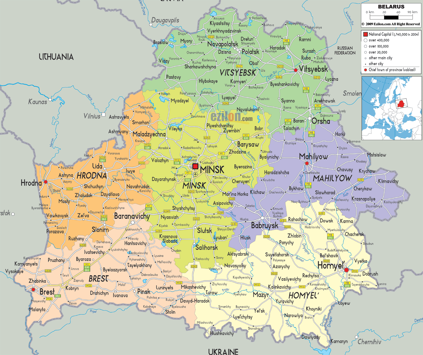
Description: Detailed large political map of Belarus showing names of capital cities, towns, states, provinces and boundaries with neighbouring countries.
Map of Belarus, Belarus map with cities, major cities, and road network are phrases people often type when they really want a map of Belarus. Our Belarus map with cities is a detailed map that shows every region, the main oblast capitals, medium-sized towns, and the clean road links that connect them. Because the best map for readers is one that matches what they can actually see, this guide walks you through our sheet step by step so residents, travelers, and geography students can visually follow each region as we go.
Belarus sits in the heart of Eastern Europe. On our map, you can see Lithuania to the northwest, Latvia to the north, the Russian Federation to the northeast and east, Ukraine to the south, and Poland to the west around Brest and Hrodna. The country has no coastline, so roads and rail lines act as the main international corridors. The detailed map of Belarus highlights how these routes fan out from Minsk and from border cities like Brest and Homyel.
Belarus is has mostly plains that are given variation by gentle hills, forests and morasses. The map shows expansive floodplain rivers and a web of small lakes and streams. Major rivers such as the Dnieper, Sozh, Pripyat, and Neman are shown as blue lines that flow south or west into neighbouring countries. Many vital cities sit along these rivers because they have historically been transport and trade routes.
Administratively, the map divides Belarus into six large regions (oblasts) plus the city of Minsk with special status. Each region is colour shaded:
Brest Region in the southwest
Hrodna Region in the west
Minsk Region in the centre
Vitsyebsk Region in the north
Mahilyow Region in the east
Homyel Region in the southeast
The detailed map labels each of these regions with its name in bold capitals. Within each coloured oblast, you see one larger dot for the regional capital and many smaller symbols for district centres and rural towns. Road lines link these places and often cross regional borders, which helps you understand how the national network fits together.
When you look at our Belarus map with cities from a distance, what stands out is Minsk, the national capital, in its central position. A bold square symbol marks Minsk in the middle of the sheet, surrounded by ring roads and spokes that reach out in all directions. These roads connect Minsk to Brest in the southwest, Hrodna in the west, Vitsyebsk in the north, Mahilyow in the east, and Homyel in the southeast.
The map uses clear symbols and colours:
A red square with a dot for the national capital
Red circles for regional capitals like Brest, Hrodna, Vitsyebsk, Mahilyow, and Homyel
Smaller circles for other cities
Tan and white lines for primary and secondary roads
By following these lines and dots, you can use the detailed map almost like a storyboard. The best way to learn Belarusian geography is to imagine you are travelling from one region to another, tracing the roads, noticing which towns appear, and seeing how the names cluster along river valleys.
At the heart of the map is Minsk, highlighted with a bold label and a square symbol. Our detailed map shows Minsk slightly to the east of the country's north–south centre. From this point, major roads radiate outward toward Barysaw in the north, Baranavichy in the southwest, Babruysk in the southeast, and Molodechno in the northwest.
The Minsk Region around the capital is shaded in yellow. Towns such as Maladzyechna, Slutsk, Salihorsk, Borisov, Zhodzina, Dzyarzhynsk, and Smalyavichy appear as smaller dots linked by a mesh of roads. Geography students can see that the region forms a hub where many routes cross, which explains why Minsk became the main political and economic centre of Belarus.
Several rivers run through the Minsk Region, and you can see how roads often follow them. For example, routes run along the Berezina valley toward Barysaw and further north. Other roads cut across low ridges toward Vitsyebsk, Mahilyow, or Hrodna. On the map, ring roads and radial routes create a pattern around Minsk that is easy to follow even if the individual highway numbers are not printed.
For residents, this part of the Belarus map with cities is helpful for planning trips and visualising commuting corridors. For visitors, it clearly shows that day trips from Minsk can reach almost every corner of the country by staying on these main spokes.
In the map’s lower left corner, we can see the Brest Region highlighted with peach colors. The city of Brest is in the western border. It is denoted with a red circle and has been labelled in bold. It’s located not far from the Polish border and at the intersection of the central rail as well as road routes from Warsaw. The main roads from Brest go northeast to Kobryn, Pinsk, and Baranavichy.
Other towns in the Brest Region, such as Pruzhany, Ivatsevichy, Luninets, Ivanava, and Malaryta, are shown along roads and river crossings. By following these lines on our detailed map of Belarus, you see how the region stretches from the Polish border across marshy lowlands to meet the central Minsk and Homyel regions.
North of the Brest Region, the map shows Hrodna Region in orange. The city of Hrodna (Grodno) lies near both the Polish and Lithuanian borders, clearly marked in red. From Hrodna, roads branch out to Lida, Ashmyany, Slonim, Vaukavysk, and Smarhon. A road also runs northeast toward Vilnius, Lithuania, which is indicated just outside the country's boundary.
Hrodna Region features gently rolling uplands, and many towns lie along the main route between Hrodna and Minsk via Lida and Slonim. For travelers who want to understand cross-border links, this western band on the Belarus map with cities is one of the best map segments to study because it shows how Belarus connects to the Baltic region and Poland.
At the top of the map, shaded green, lies the Vitebsk Region. The city of Vitsyebsk is located near the Dvina River, with roads linking it southward to Orsha in the Mahilyow Region and westward to Lepel and Polatsk. Towns such as Hlybokaye, Braslaw, Sharkawshchyna, and Navapolatsk appear near numerous small lakes and forested areas, indicating that this is one of the most wooded parts of Belarus.
From an educational perspective, this part of the detailed map of Belarus shows that northern rivers often drain toward the Baltic Sea rather than the Black Sea. The layout of towns along river bends and lake shores also reveals how settlement patterns follow waterways and glacial landscapes.
Vitsyebsk Region borders Latvia and the Russian Federation to the north. There is a road on the maps from Polatsk and Vitsyebsk toward this border. This visual link helps residents and researchers understand why the region has long been part of trade routes between Belarus, Russia, and the Baltic ports.
To the east of Minsk and south of Vitsyebsk lies Mahilyow Region, shaded in purple. Its capital, Mahilyow, sits near the Dnieper River and is marked with a red circle. Roads connect Mahilyow to Minsk, Babruysk, Bykhaw, Krychaw, and Asipovichy. The pattern shows that Mahilyow is a key node on east–west and north–south routes.
Within the region, you will find cities like Babruysk, clearly marked south of Mahilyow near the Berezina and Drut rivers. The detailed map of Belarus shows how roads from Babruysk connect with Homyel Region in the south and with Minsk Region in the west. That makes the Mahilyow Region important for freight moving between Russia and central Belarus.
The eastern edge of the map lines up with the Russian Federation. Several roads run almost parallel to the frontier, linking border towns and crossing points. The Dnieper and Sozh river systems, drawn in blue, guide many of these routes. For geography students, the Mahilyow Region is a good case study of how river valleys organise a transport network in lowland Eastern Europe.
You can spot the Homyel Region-often spelled Gomel-at the bottom right of the map which is light yellow in color. The regional capital of Homyel is located by the Sozh River. The roads from Homyel lead North towards Zhlobin, and West towards Rechytsa and Mazyr, and further South towards the Ukrainian border.
Other towns in Homyel Region, such as Svietlahorsk, Kalinkavichy, Narowlya, and Dobrush, appear along the Sozh and Pripyat basins. By tracing these on our Belarus map with cities, you see how the region stretches across river floodplains and forests that form part of the wider Pripyat marsh system shared with Ukraine.
Ukraine lies along the southern border of Homyel and Brest. The detailed map shows road and rail lines heading towards Ukrainian cities like Chernihiv, just outside the Belarusian border. For travelers, the map section indicates where the main border crossings are located. For residents, it underlines the importance of Homyel and Brest as southern gateways for trade and transport.
Our detailed map of Belarus is designed to be the best map style reference, working on several levels.
Residents can quickly locate their hometown, see which oblast it belongs to, and understand how local roads connect to Minsk or the nearest regional capital.
Travelers can plan itineraries that combine major cities such as Minsk, Brest, Hrodna, Vitsyebsk, Mahilyow, and Homyel with smaller towns such as Polatsk, Slonim, or Pinsk. The road network drawn on the map helps them estimate direction and relative distance.
Geography students and researchers can study the relationships among rivers, forests, marshes, and settlement patterns. Because the map clearly shows regions and borders, it also works as a case study in Eastern European political geography.
By reading this long-form description while following our map of Belarus, you deepen your understanding of how regional capitals, minor towns, rivers, and road corridors fit together inside a landlocked country that links the Baltic and Black Sea basins.

Physical Map of Belarus
Physical map and map image of Belarus.

Road Map of Belarus
Road map and map image of Belarus.

Regional Directory of United States of America
Information and guide about United States of America and websites with American topics.

Regional Directory of Europe
Information and guide about Europe and websites with European topics.

Regional Directory of Australia
Information and guide about Australia and websites with Australian topics.