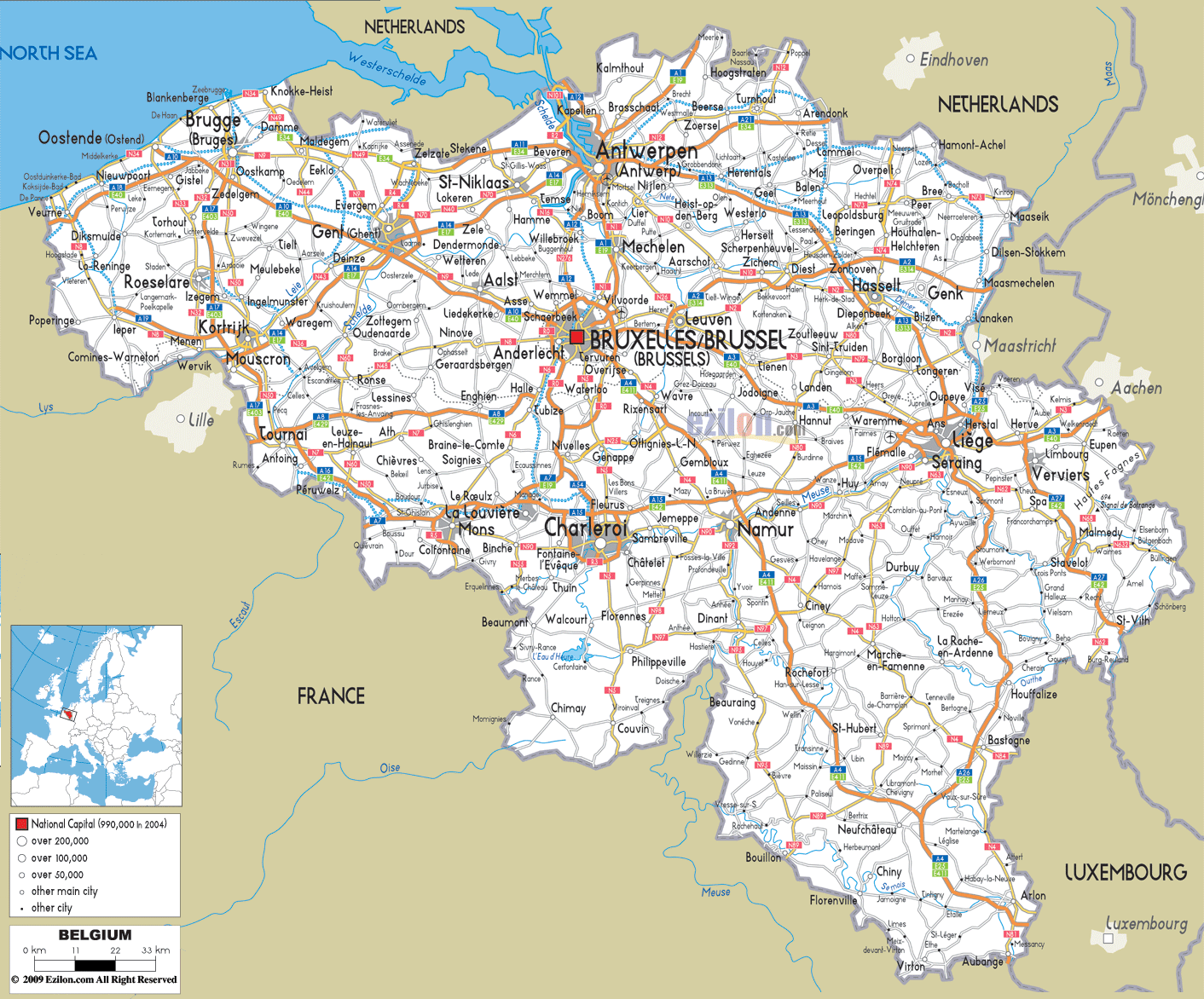
Description: Detailed clear large road map of Belgium with road routes from cities to towns, road intersections in regions, provinces, prefectures, also with routes leading to neighboring countries.
 Detailed map of Belgium with Road Map of Belgium with Highways and Expressways connecting cities, towns and neighboring countries including France, Netherlands, Germany and Luxembourg. If you’re a geography buff or someone who loves to go on road trips, or maybe you are a student who is learning about the infrastructure of Europe, Belgium road map will offer a great view of how its cities, towns and highways are linked. From coastal highways to cross-border expressways, Belgium’s roads crisscross through all major provinces, providing access to stunning architecture, forests, river valleys, and industrial centers.
Let’s begin our detailed journey from the northwest coast and drive our way across Belgium, city by city, road by road, with detailed references from the above map.
We start our road journey in West-Vlaanderen (West Flanders), hugging the North Sea coastline. Here, the E40 motorway dominates as it runs from Oostende (Ostend) eastward. Look at E40 closely - it stretches across the coast from Nieuwpoort and Gistel, eventually linking to Brugge (Bruges), a key tourist city.
Other roads along the coast are the N34, which zigzags along the seaside towns of De Haan, Blankenberge and Knokke-Heist. Beach lovers depend heavily on these areas, which link to internal highways.
From Brugge, a dense road web forms, including E403, which drives southward toward Roeselare and Kortrijk. Notice the small towns like Tielt, Izegem, and Waregem dotting the N50 and N382 roads.
To the west, Mouscron and Menin sit near the French border, served by the E403 and smaller national roads like N58 and N512.
In Hainaut, the city of Tournai is reached via E42, which cuts diagonally across southwestern Belgium. Bus lines N7, N60 and N507 provide access to rural towns like Leuze, Frasnes and Ath. This is an important connection between agricultural towns and industrial towns.
Moving northeast, the map highlights Antwerpen (Antwerp), one of Belgium's largest ports. E19, E313, and E17 form a critical junction here. The R1 ring road around Antwerp is a busy highway linking to cities like Mechelen, Lier, and Turnhout.
To the north, roads like N49, E34, and N12 extend to the Dutch border, passing towns like Kapellen, Brasschaat, and Kalmthout.
East of Antwerp, the E313 slices through Herentals, Geel, and Hasselt in Limburg province. Meanwhile, E314 leads southeast toward Genk, Maasmechelen, and on to Aachen in Germany.
Smaller roads such as N73, N74, and N76 connect towns like Bree, Zonhoven, and Diepenbeek, crucial for regional commuting.
The capital, Bruxelles/Brussel, is a star-shaped road hub. The R0 Ring Road completely encircles the city, intersecting with all major motorways - E40, E411, E19, and E429.
Pay attention to the urban exits: roads like N9, N4, N6, and N8 radiate outward from Brussels, reaching towns like Zaventem, Dilbeek, Waterloo, and Overijse.
To the east of Brussels, Leuven is a key university city, easily accessed via E40 and N2. Mechelen, halfway to Antwerp, is another well-connected city via E19.
Surrounding towns like Vilvoorde, Tervuren, and Wavre form part of the commuter belt served by local and express roads.
Charleroi, located in Hainaut, lies on E42 and E420, linking it to Mons, Philippeville, and Namur. The map shows Charleroi's dense local road system - N5, N53, N90 - serving smaller towns like Chimay, Thuin, and Binche.
Namur, the capital of Wallonia, is positioned on E42 and E411, with direct access to Dinant, Andenne, and Eghezée. As you follow the E42, you reach Liège, Belgium’s third-largest city. Major highways like E25, E40, and E313 intersect here, making it a crucial transport node.
Check out the routes along the Meuse River - the map shows scenic roads such as N90 and N61, which pass through Huy, Amay, and Seraing.
To the east, Verviers connects to E42 heading toward Eupen and Raeren, close to Germany. Local roads like N68 and N61 link natural parks and small German-speaking communities.
The E25 stretches south from Liège into Bastogne, a historic WWII town. N4 from Namur goes through Marche-en-Famenne, Rochefort and ends at Arlon.
Arlon, near the Luxembourg border, is linked by E411 and N4, making it a gateway city for EU travelers. N81, N85, and N88 provide access to nearby villages like Florenville, Neufchâteau, and Bouillon.
In this hilly, forested part of Belgium, the road map shows narrower, winding roads - N89, N899, and N819—ideal for scenic drives through Saint-Hubert, La Roche, and Vielsalm.
E40: Spans east-west from Oostende to Liège, exits into Germany
E19: North-south route from Antwerp to Mons and France
E411: Connects Brussels to Arlon via Namur
E42: From Tournai through Charleroi, Namur, Liège, to Verviers
Each N road serves inter-city and rural traffic. Examples include
N4: Major route from Brussels to Arlon
N5: Brussels to Charleroi and Philippeville
N90: Along the Meuse River from Liège to Namur
Northern roads like E313, E314, and E40 cross into the Netherlands near Maastricht, Eindhoven, and Roermond. In the east, E42 and N68 cross into Aachen, Germany.
To the south and southwest, E19, E42, and E411 provide smooth access to France, while E25 and E411 lead into Luxembourg, making Belgium an essential transit nation.
The detailed road map of Belgium indicates a small yet well-connected country. They take you from the plains of Flanders to the hilly Ardennes while going through towns, villages, rivers, and borders.
This map is a great example of transportation geography for students. For the traveler, it is the planner’s wish come true – with direct highways, scenic byways and city connectors across the nation
Belgium’s roads do not only connect points on a map; they connect to adventure, culture, and discovery. Follow this guide to understand how to get around a country through engineering and geography.

Political Map of Belgium
Political map and map image of Belgium.

Physical Map of Belgium
Physical map and map image of Belgium.

Regional Directory of United States of America
Information and guide about United States of America and websites with American topics.

Regional Directory of Europe
Information and guide about Europe and websites with European topics.

Regional Directory of Australia
Information and guide about Australia and websites with Australian topics.