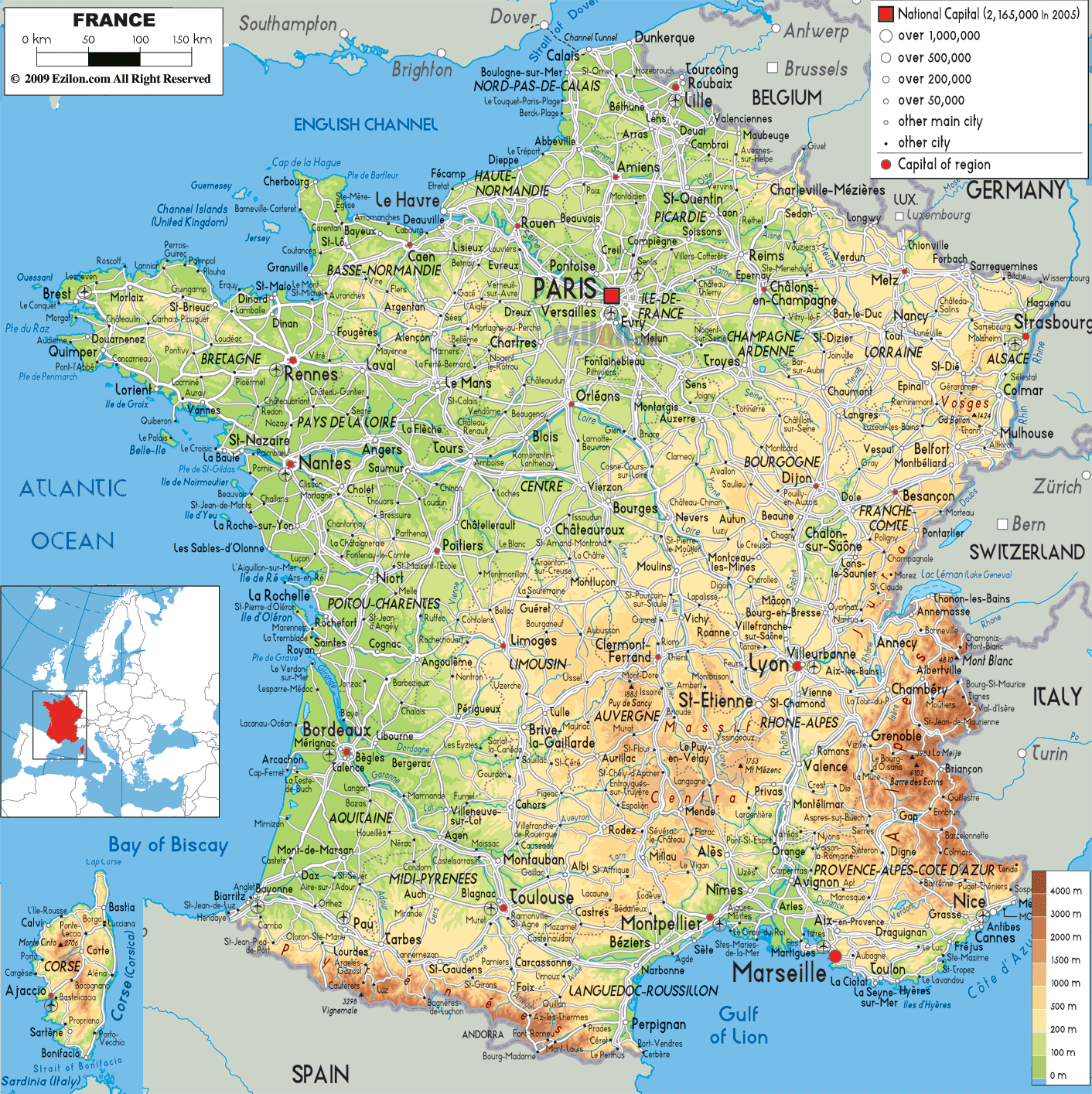
Description: The physical map of France showing major geographical features like elevations, mountain ranges, seas, lakes, plateaus, peninsulas, rivers, plains, landforms and other topographic features.
 France is a western-European country with many geography differences. France has plains, ranges, valleys and coastlines, which make up its physical map. Whether you're a geography student eager to understand physical topography or a traveler fascinated by terrain, this guide narrates the full physical landscape of France with attention to every visible feature on the map. You will not just learn about mountains and rivers, but you will be visually led across the contours of one of Europe's most scenic nations.
Begin at the map’s northern tip, along the coast of the English Channel (La Manche). Cities such as Calais, Boulogne-sur-Mer, Dunkerque are on the Coast. The elevation is not high and the terrain not very harsh as it is part of North European Plain.
This region is known for its windy coastline, chalk cliffs (like the Cap Blanc-Nez), and dunes. The cities of Rouen, Dieppe, and Le Havre (visible inland and along the coast) lie within Normandy, a region of gently rolling farmland and river valleys, especially along the Seine River, which snakes westward into the Atlantic.
The inland area, The Paris Basin occupies the land. The map uses light green and yellow to show where the land is low, soft and fertile. This geological basin takes an easy broad bowl form with Paris at its geographic centre and radiating towards Amiens, Reims, Chartres, Orléans and Châlons-en-Champagne.
Areas where the soil are chalk or limestone are thought to be very productive. There is a strong cereal farming presence here. The Marne and Oise rivers can also be followed as they meet in Paris, at the Seine.
Moving westward, the Brittany Peninsula (see Brest, Quimper, Lorient, and Saint-Brieuc) juts into the Atlantic Ocean. The coastline here is rugged, and the land slightly rises as part of the Armorican Massif, an ancient mountain range worn down into rolling hills.
The terrain here is granite-based, and inland cities like Rennes and Vannes lie amidst undulating terrain.
Look at the central-western portion of the map, where the Loire River winds from Orléans westward past Tours, Angers, and Nantes into the Bay of Biscay. The river's wide valley is surrounded by gentle slopes and fertile lands. This region forms a UNESCO World Heritage Site, known for vineyards, castles, and broad, navigable waterways.
The nearby land is flat and good farming land, one of France's best farming belts.
Dominating the central portion of France, the Massif Central is one of the most significant features on the map. Seen in shades of brown and rust, this ancient highland region features volcanic peaks, plateaus, and deep river gorges.
Cities such as Clermont-Ferrand, Aurillac, Le Puy-en-Velay, and Rodez lie within this region. You’ll notice how the terrain rises significantly compared to the surrounding plains. This region is home to extinct volcanoes such as Puy de Dôme and Puy Mary, along with vast lava plateaus.
The Loire River originates here, flowing northward. The terrain is challenging for farming but excellent for pastoralism and hiking.
Moving slightly west, see Limoges, Brive-la-Gaillarde, and Tulle in the region of Limousin, and Mende and Le Puy in Auvergne. This region transitions from rugged highlands into forested hills and deep valleys. Numerous rivers like the Dordogne and Lot carve through the region.
Look to the eastern edge near Besançon, Lons-le-Saunier, and Pontarlier, and you'll spot the Jura Mountains running parallel to the Swiss border. These mountains are folded and faulted, forming long ridges and valleys.
The elevations gradually increase as you move southward into the Alps. The terrain is limestone-dominated and supports winter tourism and cheese production.
Perhaps the most dramatic terrain in all France appears southeast. The French Alps (orange-brown zones) contain the country’s highest elevations.
Grenoble lies at the base of these mountains.
Chambéry, Gap, and Briançon sit further east in alpine valleys.
Mont Blanc, the highest point in Western Europe at 4,808 meters, is located on the border with Italy.
These jagged peaks are glaciated and home to rivers such as the Isère and Durance, which flow into the Rhône.
On the northeastern border near Strasbourg, Mulhouse, and Colmar, the land flattens into the Alsace Plain along the Rhine River. This river forms a natural border with Germany and is part of the Upper Rhine Graben, a rift valley with fertile soils.
This region is dominated by vineyards and appears green and relatively flat on the map, nestled between the Vosges Mountains to the west and the Black Forest across the Rhine.
Trace your eyes to the southwestern border with Spain and you’ll see the Pyrenees Mountains. These form a natural border, rising sharply near Pau, Tarbes, and Foix, extending eastward toward Perpignan.
They are sharply marked in dark brown and orange tones, signifying high elevation. The Pic du Midi and Vignemale are key peaks here. The Pyrenees are less glaciated but just as dramatic as the Alps.
Cities such as Montpellier, Nîmes, Carcassonne, and Perpignan lie in gently sloping terrain leading to the Mediterranean. The landscape is flatter here with limestone plateaus and fertile plains.
The Canal du Midi, one of the oldest canals in Europe, flows west from Toulouse toward the sea, and this lowland is ideal for vineyards and olive groves.
Further East, Marselle, Toulon, and Nice embrace the Mediterranean Sea. Maritime Alps rise behind them, extending into Italy. Digne, Sisteron, and Grasse: steep ridge and wooded valleys with no room for sprawl
The Verdon River made the Verdon Gorge, France's Grand Canyon, with its cuts into limestone rock.
This is a land of lavender fields, high plateaus, and azure coastlines.
Originates in northeastern France.
Passes through Troyes, Paris, Rouen.
Empties into the English Channel at Le Havre.
Longest river in France.
Passes Orléans, Tours, Angers, Nantes.
Starts in the Pyrenees.
Flows through Toulouse, Agen, Bordeaux.
Empties into the Bay of Biscay.
Originates in the Swiss Alps.
Flows through Lyon, Valence, Avignon, Arles.
Reaches the Mediterranean Sea at the Camargue region.
Visible in the bottom-left insert, the mountainous island of Corsica is covered in reddish-brown indicating high terrain. Major cities are Ajaccio and Bastia. The island is known for its jagged peaks and dense forests.
France's physical geography is as varied as its culture. The French – people, history, economy, and above all, the land have all contributed to the formation and shape of the country. Every part of France is unique. The physical map of France shows that every region has their own natural character. Being more familiar with France's geography opens the country's true face to the students of geography and the travelling public alike.

Political Map of France
Political map and map image of France.

Road Map of France
Road map and map image of France.

Regional Directory of United States of America
Information and guide about United States of America and websites with American topics.

Regional Directory of Europe
Information and guide about Europe and websites with European topics.

Regional Directory of Australia
Information and guide about Australia and websites with Australian topics.