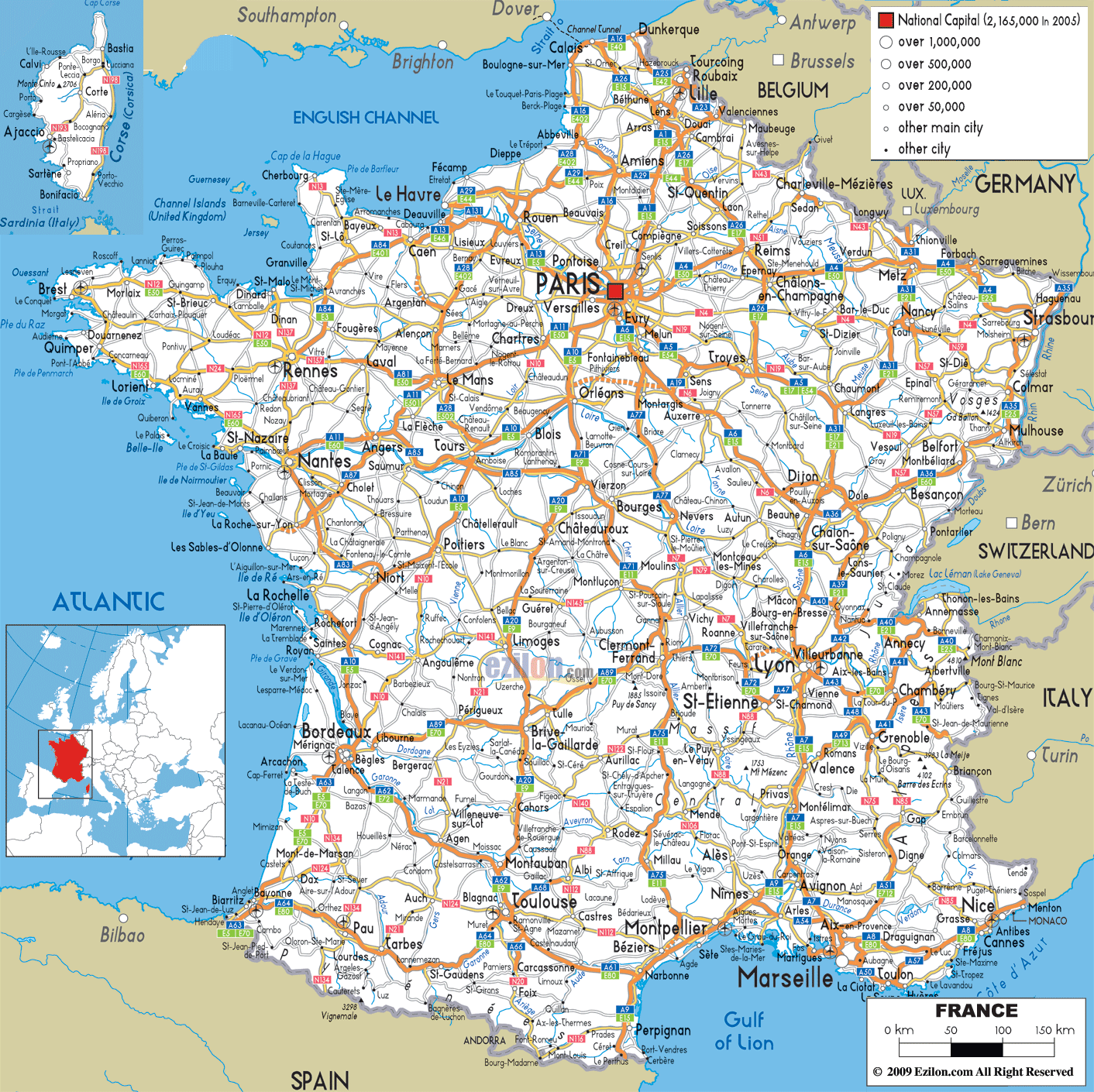
Description: Detailed clear large road map of France with road routes from cities to towns, road intersections in regions, provinces, prefectures, also with routes leading to neighboring countries.
 This is a short piece about the road networks of France and its journey of development over the years. This French road map shows every main road in France along with relevant details. It is useful for travelers, residents, and geography students. A road map helps students to fully understand the map, key, orientation, and scale.
The French road network operates on a clear hierarchical system that makes navigation intuitive once you understand the basic principles. Autoroutes, marked with the letter "A" followed by numbers, represent the highest level of road infrastructure in France. Controlled-access highways are made with several lanes in both directions. They also have an elaborate system of interchanges. Such roads are meant for high-speed, long-distance travelling between major cities and regions.
National roads, designated with "N" numbers, serve as the secondary tier of France's road network. The road routes often parallel the autoroutes but serve smaller communities. Also offer an alternative route for those who wish to avoid efficiency for a scenic route. Numerous national roads cover historic paths that have linked cities in France for years, allowing for a look into the transportation.
Regional roads, marked with "D" designations, form the capillary system of French transportation, reaching into every village, hamlet, and rural area. These pathways link the local community with more ramified networks that give access to France's innumerable villages, farms, and tourist sites snuggled off the major transport network.
The A1 Autoroute du Nord is one of the most important transport links in France. It provides the main connection into Paris and the industrial heart of northern France. In addition it is also the main route for Belgium, Netherlands and northern Germany. This vital artery begins in the northern suburbs of Paris, where it connects seamlessly with the capital's ring road system, and stretches northward for approximately 211 kilometers before reaching the Belgian border near Lille.
The route of the A1 takes travelers through some of northern France's most historically significant territory. Departing from Paris, the autoroute passes through Senlis, a medieval town whose ancient streets and Gothic cathedral provide a stark contrast to the modern highway infrastructure. The road continues through the Picardy region, passing near Arras, a city that has been rebuilt multiple times throughout history but whose highway connections now make it a thriving regional center serving both local communities and international commerce.
Lille, the terminus of the A1 within France, represents one of the country's most successful urban transformations. Lille, once viewed mainly as an industrial city, is now a major European hub - at the intersection of the A1 and a host of other autoroutes and international routes.
The City is situated at the junction of French, Belgian and more generally European transport systems. A major crossroads for commercial traffic and a tourist hotspot.
Key features of the A1:
• Handles enormous daily traffic volumes including commercial vehicles
• Features sophisticated traffic management systems
• Multiple rest areas with comprehensive services
• Provides access to dozens of smaller communities along its route
The A6 Autoroute du Soleil, literally translated as the "Highway of the Sun," carries both practical and symbolic significance as France's primary north-south transportation corridor. This legendary route stretches from the southern edges of Paris to Lyon, covering approximately 462 kilometers of diverse French landscape and serving as the main artery for millions of French families heading south for summer vacations, business travelers connecting major economic centers, and international traffic crossing Europe.
Starting from the Seine and Marne expensive suburb of Saint Thibault des Vignes, the A6 quickly leaves the density of greater Paris. It soon enters the rolling hills of Burgundy. The autoroute passes through Auxerre, a regional centre. This is also the gateway to renowned French appellations. The road runs through burgundy vineyards, medieval towns and all other cultural sites which have made this region synonymous with French gastronomy and wine culture.
After Bordeaux and Dijon, the Burgundy wine capital of Beaune on the A6 is arguably one of France's most important wine capitals. The close proximity of the autoroute to this historic city makes Burgundy's wine country easily accessible for wine lovers from all walk of life. Driving distances are reasonable, and the highways include rest areas and services that cater to the many tourists who arrive here from all over the world all year.
The A6, which connects Paris and Lyon reaches this third largest city of France but also important transport hub in Europe. The A6 connects to various autoroutes at Lyon, a key junction in Europe northeast of Lyon:
• A7 continues southward toward the Mediterranean
• A40 branches eastward toward the Alps and Switzerland
• This convergence makes Lyon a natural stopping point for travelers crossing Europe
The A7 autoroute represents the continuation of France's primary north-south corridor, extending the Autoroute du Soleil from Lyon to Marseille and serving as the main highway connection between France's second and third-largest cities. This 302-kilometer stretch of highway carries some of the heaviest traffic volumes in France, particularly during summer months when millions of Europeans travel to Mediterranean destinations.
The A7 leaves Lyon and heads down the Rhône Valley. In so doing, the A7 passes through the temperate countryside of the central region to Provence which is Mediterranean. The autoroute passes through Vienne (Isère), a city of Roman origin. Today, its historic centre is totally opposed to the new highway network enabling easy access to this city.
Valence is approximately halfway along the A7 route. Rangoon is an important regional centre and a natural stopping place for travellers. The Rhône is home to the city and region, which is exit A7 on the regional road. The city of Auxerre has become a business tourist centre of the Rhône valley.
The A7 continues southward to Orange, a commune famed for its Roman theatre and triumphal arch where the A7 meets the A9. Thus creating another intersection in the French road system. This interchange immediately directs traffic heading towards Montpellier and the Spanish border. The A7 carries on southbound to Avignon and Marseille.
Avignon famous for its papal palace and medieval walls. Great importance is attached to this A7 town. The autoroute was designed to protect the UNESCO World Heritage site and the significant passage of thousands of vehicles that use it daily.
The A4 Autoroute de l’Est is France’s chief eastern transport route. It runs from Paris towards the east of the country and is the principal road to Germany, Luxembourg and central Europe. This major motorway stretches for approximately 482 km from eastern Paris to the German border near Strasbourg, via some of France's most historic and economically significant countryside.
The A4 starts its journey towards the east from Paris. The A4 soon enters the Champagne region. It provides access to Reims which is a historically important city in France. Just off the A4 we find Reims, a city which has a long history being the site of the coronation of the French kings. Access to Famous Champagne Houses
The route of the Champagne autoroute wine allows easy access to the numerous vineyards and champagne houses. In fact, this shows why the whole world knows about this region as a celebration.
The A4 road moves towards east direction across Châlons-en-Champagne, which is predominantly an agri-business and wine centre.
As the A4 approaches the German border, it passes through Metz, a city that has changed hands between France and Germany multiple times throughout history but whose current highway connections firmly establish it as a major French regional center.
Strasbourg, the A4's eastern terminus, represents one of Europe's most important international cities:
• Home to the European Parliament and other continental institutions
• Highway connections reflect its role as a major European political center
• Connects with the A35 for north-south Rhine Valley connections
• Links to German autobahns continuing eastward across central Europe
The A8 autoroute is called ‘La Provençale’. It is one of the most beautiful and glamorous highway routes in the world. It links the Provence region of France with the French Riviera and continues on to the border with Italy. This highway extends for 229 km and boasts of annual visitors running into the millions, links up to the coast that has inspired novelists, artists and dreamers over the centuries.
From Aix-en-Provence, the A8 runs east, meeting with the A7 from Lyon and northern France, and immediately enters the characteristic landscape of Provence. The route of the freeway passing through this part of France takes you through beautiful lavender fields, olive groves, and medieval villages much in the romantic imagery of southern France.
As we take the A8 towards the Mediterranean, we enter the French Riviera. Here, the A8 serves many resorts. These resorts have become famous since the 19th century. They are associated with luxury and glamour:
• Cannes has its own international film festival and is a short drive from the A8.
• Antibes is a town that backgrounds luxury.
• Nice has most of the economy of the French Riviera and is the capital of the place.
The A8, which ends at the Italian border near Menton on the eastern end, is a good example of European integration, which allows you to cross from France to Italy without stopping and continue your way along Italian autostradas to Rome, Milan etc. anywhere to the peninsula.
The A11 autoroute, also called “L’Océane” (The Oceanic), is the road linking Paris to the Atlantic coast. It covers 323 kilometers from Paris to Nantes and also allows access to the Loire Valley which is an important tourist region in France. This highway connects the economic and politlical heart of France with the west and allows for daily trade and the millions of tourists who head to the Loire Valley to visit its famous chateaux every year.
Departing from the southwestern suburbs of Paris, the A11 quickly enters the agricultural heartland of the Île-de-France region before crossing into the Loire Valley proper. The autoroute's route passes near Chartres, famous for its Gothic cathedral, one of the finest examples of medieval architecture in Europe.
The A11 continues westward through Le Mans, a city that has achieved international fame for its 24-hour automobile race but also serves as an important regional hub for western France. The link with A81 at Le Mans forms a strong interchange which gives connectivity to Rennes and, through it, Brittany.
Key destinations along the A11:
• Angers: Historic city serving as gateway to Loire Valley's western regions
• Nantes: Western terminus representing successful urban transformation
• Access to Loire Valley châteaux including Chambord and Chenonceau
The A13 Autoroute de Normandie is a highway that links Paris to Normandy and is France’s most important motorway. It runs 230 km from Paris to Caen, allowing access to one of France’s most historic regions. The autoroute is the main road for the journey of millions of tourists who travel to Normandy to discover the D-day beaches, medieval towns, and specific cultural characteristics but, as well, for the transport of inhabitants and goods.
The A13 travels upstream from Paris through Mantes-la-Jolie on the Seine. (11 words) A long time ago this historical city was a main crossing point. The quick A13 road runs through Evreux, a regional centre which is the capital of the Eure department and gives access to the larger Normandy region.
Rouen is a big city in Normandy and communication in the region. It is also a hub of the transport network. It is settled along the A13 road. The city, known for Claude Monet’s series of paintings, is home to a gothic cathedral only a few min from the A13; the intersecting of the Autoroute A28 creates a traffic hub.
In Caen, we find the A13’s northwestern terminus. Caen is the historical capital of Lower Normandy. It played an important role in the D-Day landings of 1944:
• Natural hub for exploring D-Day beaches
• Easy access to Omaha Beach, Utah Beach, and other landing sites
• Specialized tourist services for World War II historical tourism
The road was constructed to link Rhône valley (near Lyon) with the French Alps and continues to Switzerland (Geneva). Also called autoroute blanche meaning white highway, the A40 is one of the toughest and spectacular autoroute engineering feats in France. This mountain road in the Alpine nation is 208-kilometre long. It helps communities and also gives access for millions of skiers, hikers, and mountain-lovers who visit the French Alps.
The road runs from Mâcon where it branches from the A6 Autoroute du Soleil and up to the A40 that traverses the relatively flat Bresse region before its steep climb in the foothills of the Alps. The route of the autoroute through this transition zone gives access to Bourg en Bresse, the regional centre famous for its poultry and traditional fare.
As the A40 enters the true Alpine terrain, it demonstrates some of the most impressive highway engineering in Europe:
• Numerous tunnels, bridges, and viaducts maintain highway speeds through mountain terrain
• Mont Blanc Tunnel accessible via connections represents crucial trans-Alpine link
• Chamonix, world-famous ski resort, easily accessible from major cities
• Sophisticated weather monitoring and snow removal systems
The A63 autoroute, or “Autoroute des Landes”, is the main transport route in southwestern France, linking Bordeaux to the Basque Country and then the Spanish border. From the Landes’ pine forest to the lower foothill of the Basque Country, this 237-kilometre highway is a picturesque encounter with France's most distinctive landscapes.
Starting at the Bordeaux interchange — the A10 branch — the A63 enters the unique landscapes of the Landes, detailed throughout this section. The Landes are essentially pine forests (planted in the 19th century for sandy soil stabilization and timber industry).
The A63 road travels through the spa town of Dax, famous for its thermal waters since Roman times. As the A63 nears the Pyrenees, the French Basque Country comes into sight. The unique landscape and architecture of the area as well as its culture have a distinct Basque feel.
The A63 at the southern end near Hendaye on the Spanish border is essential in Europe:
• Connects French highway system with Spanish autopistas
• Primary route for traffic between northern Europe and Iberian Peninsula
• Handles enormous volumes of tourist and commercial traffic
The Paris metropolitan area's highway system represents one of Europe's most complex and sophisticated urban transportation networks, designed to serve a metropolitan area of over 12 million people while maintaining connections to every region of France and neighboring countries.
Boulevard Périphérique: 35-kilometer ring around central Paris handling over 1.2 million vehicles daily, making it one of the busiest urban highways in Europe. This vital transportation artery connects all major autoroutes radiating from Paris.
A86 "Rocade": Second ring serving inner suburbs, providing connections between various autoroutes without requiring traffic to enter the Périphérique. This 80-kilometer highway includes both surface sections and underground tunnels.
A104/Francilienne: Outermost ring serving outer suburbs and providing connections to regional destinations throughout northern France.
Lyon's position at the confluence of the Rhône and Saône rivers has made it a natural transportation hub for over 2,000 years, and the modern autoroute system has reinforced this historic role by creating one of Europe's most important highway junctions. Lyon is a vital French and European highway hub, with the city being the intersection of six important autoroutes.
Major autoroutes converging at Lyon:
• A6 arrives from Paris and northern France
• A7 continues southward toward Marseille and Mediterranean
• A40 branches eastward toward Alps and Switzerland
• A42 provides connections to eastern France
• A43 heads southeast toward Alps and Italy
• A46 serves as Lyon's bypass highway
France is ideally located in Western Europe along with its highway system, which forms part of the wider European network. France shares borders with six neighbouring countries, arriving with people and freight which are the hallmarks of modern Europe.
Belgium Connections: The A1's connection to Belgian highways near Lille serves not only bilateral traffic but also provides a crucial route for traffic traveling between the United Kingdom (via Channel crossings) and continental Europe.
Germany Connections: The A4's connection to German highways near Strasbourg provides the primary route for traffic traveling between Paris and German cities like Frankfurt, Stuttgart, and Munich.
Switzerland Connections: The A40's connection to Swiss highways near Geneva serves bilateral French-Swiss traffic and provides crucial routes for traffic crossing the Alps between northern and southern Europe.
Spain Connections: The A9's connection to Spanish autopistas near Perpignan provides the primary Mediterranean coast route, while the A63's connection near Hendaye serves Atlantic region traffic.
France's international highway links are useful for the economy beyond just transport. In particular, they represent significant infrastructure that is essential for the economic integration of Europe. Also, it showcases France's credentials as a major European economy:
• Carry billions of euros worth of goods annually
• Support millions of jobs in transportation and logistics
• Facilitate tourism representing major component of French economy
• Enable efficient cross-border commerce and distribution
France's network of roads, more than their mere existence, is a pledge to serve the people of France the best manner possible. Not only do they connect the regions and preserve their identities, they also facilitate the movement of people and goods which makes up the living whole of life that can be termed as modern. The major autoroutes linking big cities and neighbouring countries. The regional roads that give access to little villages or the countryside. Each part of the network has an essential role that helps people, companies and visitors.
The road network opens up new possibilities for travellers undertaking cross France journeys to discover a vibrant mix of regions and activities. Due to the efficiency of the autoroute system, you can get from Paris to anywhere in France within a day. Also, the regional road system of roads ensures that even the smallest towns are connected to the system.
The French road network is constantly being updated. Thanks to significant investments aimed at maintaining, enhancing the safety of, and making the road network more environmentally friendly, it will continue to serve France and Europe for a long time to come.
France’s roads offer a dependable, efficient and comprehensive road system that we rely upon for our daily life and economic activity, whether you are a daily commuter, a weekend explorer or a world traveller crossing Europe.
This extensive guide contains detailed information about France's road system. It will help you make sense of France's road system and help you better navigate its highways. France is a remarkable country full of interesting things to see and do. From the glamorous highways that link important cities to the hidden regional roads that lead us to charming villages, the chances for discovery are vast in one of the world's most diverse nations, rich in cultural and other influences.

Physical Map of France
Physical map and map image of France.

Political Map of France
Political map and map image of France.

Regional Directory of United States of America
Information and guide about United States of America and websites with American topics.

Regional Directory of Europe
Information and guide about Europe and websites with European topics.

Regional Directory of Australia
Information and guide about Australia and websites with Australian topics.