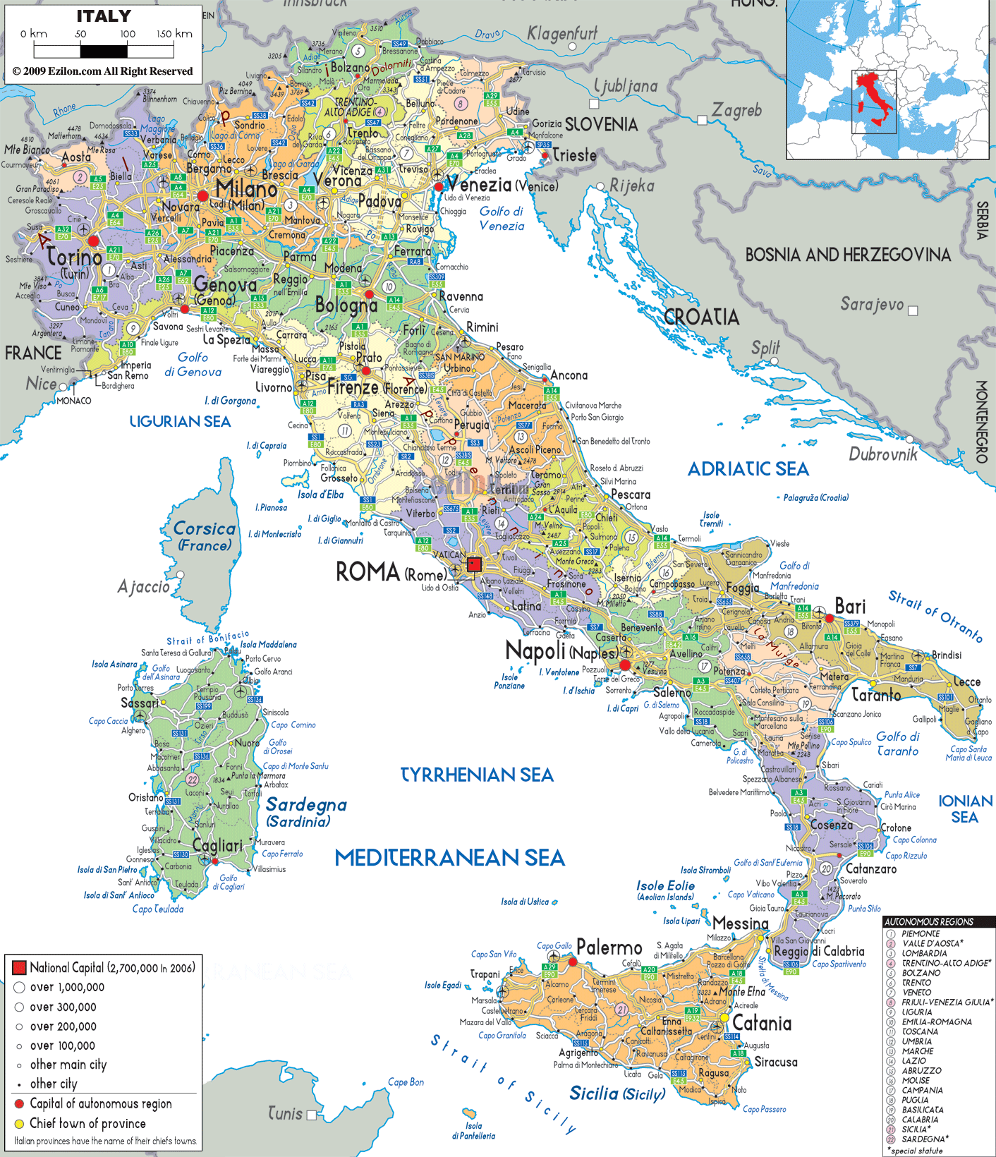
Description: Detailed large political map of Italy showing names of capital cities, towns, states, provinces and boundaries with neighboring countries. This map also indicated the autonomous regions (highlighted in numbers seen in the map) while the names and list can be seen at the end - right handside of this map.
 Map of Italy, Italy map with cities, regions, and roads network. Italy is situated in Western Europe its borders touch those of France, Germany, Switzerland, Austria and Slovenia and is nearly completely surrounded by the Mediterranean and Adriatic Seas. Rome once the capital of the Roman Empire
is Italy's capital and Italian is the official language,
although French, English and German are also spoken in
tourist centers.
Map of Italy, Italy map with cities, regions, and roads network. Italy is situated in Western Europe its borders touch those of France, Germany, Switzerland, Austria and Slovenia and is nearly completely surrounded by the Mediterranean and Adriatic Seas. Rome once the capital of the Roman Empire
is Italy's capital and Italian is the official language,
although French, English and German are also spoken in
tourist centers.
Italy also boasts some beautiful islands such as Sicily
with its still active Volcano Mount Etna, Sardinia with
a mountainous landscape and beautiful off shore islands
in turquoise waters, as well as Capri and Elba, to name
a few.
Italy's landscape ranges from the Alps and Apennines
boasting some of the highest mountains in Europe,
offering excellent skiing and hiking, central Italy with
the picturesque Tuscan valleys, lush country side and
sandy coastline and the south with its expanse of olive
trees, forests, beaches and rocky coastline.
Just to the northeast of Lombardia, Trentino-Alto Adige stands out with its Germanic town names like Bolzano and Merano, indicating the region's mixed cultural heritage. It borders Austria directly. Notice the Alpine mountain formations on the edge of this region.
Further east, Veneto is a highlight with Venezia (Venice) located right on the Golfo di Venezia. The map shows the watery environment of Venice, with canals and proximity to the Adriatic Sea.
East of Veneto is Friuli-Venezia Giulia, touching Slovenia. Cities like Trieste, Udine, and Gorizia appear here - showcasing Italy's eastern European connection.
South of these lies Emilia-Romagna, a wide band of land shaded in soft orange, extending from Piacenza in the west to Rimini in the east. The capital Bologna lies centrally. This region is rich in universities, cuisine, and industry.
Italy's political map is made up of four regions:
Toscana (Tuscany), shown in pale yellow, houses cities like Firenze (Florence), Siena, and Pisa. These cities, clearly labeled on the map, are globally renowned for art and history.
Umbria, Italy's only landlocked region without a coastline or foreign border, lies in pale green next to Toscana. Look for Perugia, its capital.
Marche, bordering the Adriatic Sea, includes Ancona and Pesaro. The coastline here curves elegantly northward.
Lazio, shown in off-white, is dominated by Roma (Rome), the nation's capital marked with a red square. The map indicates Rome's dense network of roads and proximity to Civitavecchia, a major sea port.
As we move further south:
Abruzzo and Molise, mountainous and coastal, include towns like Pescara and Campobasso.
Campania shines with Napoli (Naples), Salerno, and the Amalfi coast. Note the proximity to Vesuvius, though not visible, its presence is implied.
Basilicata is small and often overlooked, tucked between Campania and Puglia.
Calabria, the toe of the Italian boot, points towards Sicilia across the Strait of Messina. Cities like Reggio Calabria and Catanzaro are labeled here.
The map clearly separates the islands:
Sardegna (Sardinia) is in light green, with cities like Cagliari, Nuoro, and Sassari. It appears west of the mainland.
The island of Sicilia (Sicily), the largest island in the Mediterranean, is shown in light orange with Palermo, Catania and Messina. Southward lies the Strait of Sicily, which separates the Italian island from Tunisia.
Italy shares borders with:
France (near Torino)
Switzerland (above Milano)
Austria (above Trento and Udine)
Slovenia (east of Trieste)
Each border is marked with black dashed lines and shaded national regions.
On the map, you'll notice five autonomous regions—these have greater legislative power:
Valle d'Aosta
Trentino-Alto Adige
Friuli-Venezia Giulia
Sicilia
Sardegna
They are marked and listed in the bottom right of the map for easy reference.
The symbols marked on cities tell the populations:
Red square = National capital (Roma)
Green square = Capital of autonomous region
Bold black dot = Chief town of province
Circle = Population size (from over 1 million to under 200,000)
Italy's provinces follow geographic formations: mountains in the north, rolling hills in the center, coastal belts in the south.
River systems like the Po River in the north are politically important, shown meandering from west to east.
The shape of each province often matches physical barriers—mountain ridges, rivers, and coastlines.
This political map of Italy serves more than administrative clarity. It also reflects history, language diversity, migration, and regional identity. Geography students can use it to study how political lines follow natural features. Travelers can use it to understand cultural shifts between regions.
From the bustling industrial north to the historic treasures of the center and sunlit coastal towns in the south, the map visually narrates the complexity and beauty of Italy's political landscape.

Physical Map of Italy
Physical map and map image of Italy.

Road Map of Italy
Road map and map image of Italy.

Regional Directory of United States of America
Information and guide about United States of America and websites with American topics.

Regional Directory of Europe
Information and guide about Europe and websites with European topics.

Regional Directory of Australia
Information and guide about Australia and websites with Australian topics.