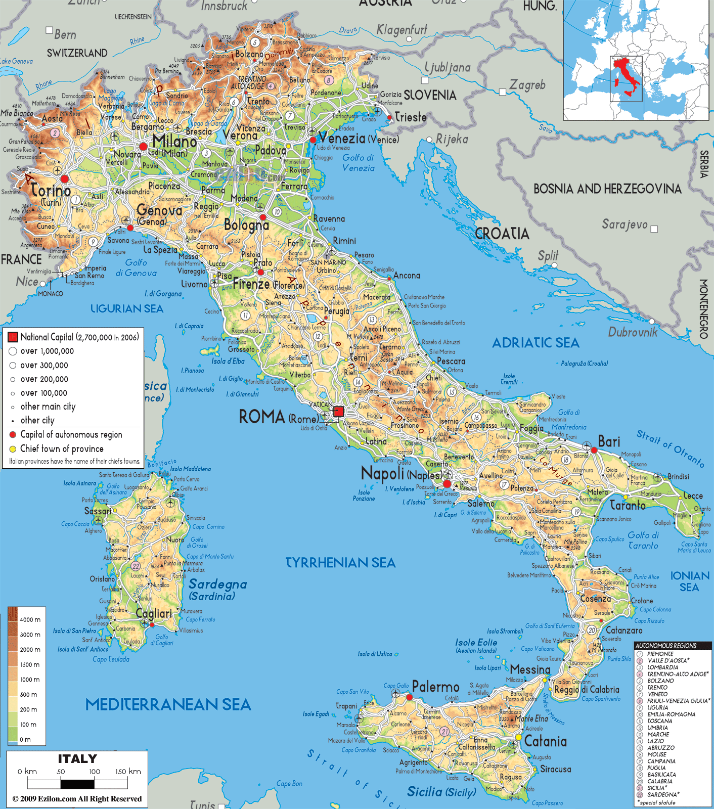
Description: The physical map of Italy showing major geographical features like elevations, mountain ranges, seas, lakes, plateaus, peninsulas, rivers, plains, landforms and other topographic features. This map also list out (indicated in numbers) all the Autonomous regions and those with special statute.
 Welcome to your comprehensive exploration of Italy's physical geography, where every mountain peak, coastal curve, and river valley tells a story of geological wonder and natural beauty. As you examine this detailed physical map of Italy, you're embarking on a journey through one of Europe's most geographically diverse countries, where the dramatic Alps meet the gentle Mediterranean, and where volcanic forces have shaped landscapes that have inspired travelers for millennia.
This physical map reveals Italy's extraordinary topographical diversity through its sophisticated elevation color coding system. Notice how the legend on the left side shows elevations ranging from sea level (0m) to the highest peaks exceeding 4000m, painted in colors from coastal greens to alpine browns and whites. The numbered regions visible throughout the map correspond to Italy's 20 administrative regions, each listed in the bottom right corner, creating a perfect reference system for understanding both political and physical geography.
As your eyes move to the northwestern corner of the map, you'll immediately notice the dramatic brown and orange coloring that indicates Italy's highest elevations. This is where the Western Alps form a natural fortress along Italy's borders with France and Switzerland. The intense brown coloring near the border with France marks some of Europe's highest peaks, including Monte Bianco (Mont Blanc), which reaches 4,807 meters and appears as the darkest brown area on the map.
Look closely at region number 2, Valle d'Aosta, the smallest of Italy's regions, nestled entirely within this alpine landscape. The physical map shows how this region is completely surrounded by peaks exceeding 3,000 meters, creating a dramatic valley system that channels the Dora Baltea river toward the Po Plain. Notice how the elevation colors transition from the darkest browns of the highest peaks to lighter oranges as you follow the valley floors, illustrating the dramatic vertical relief that characterizes this region.
The city of Aosta, visible as a small dot in the valley, sits at approximately 583 meters above sea level, surrounded by some of Europe's most spectacular mountain scenery. The map clearly shows how the Great St. Bernard Pass and Little St. Bernard Pass create historic corridors through these mountains, routes that have connected Italy with northern Europe for over two millennia.
Moving eastward, region number 1, Piemonte (Piedmont), literally means "foot of the mountains," and the physical map perfectly illustrates why. Notice how the intense brown coloring of the high Alps gradually transitions to orange and then to the green of the Po Plain as you move away from the mountain borders. The city of Torino (Turin), marked with a red square as a regional capital, sits where this transition is most dramatic, positioned at the mouth of several alpine valleys.
The map reveals the intricate network of valleys that drain the Western Alps, including the Susa Valley leading toward France and the valleys that connect with Switzerland. These valleys appear as green corridors cutting through the orange and brown mountain terrain, showing how water has carved pathways through the alpine landscape over millions of years.
Region number 3, Lombardia (Lombardy), showcases one of Italy's most distinctive physical features: the great alpine lakes. As you examine the northern part of this region, you'll see the brilliant blue of Lago di Como, Lago Maggiore, and Lago di Garda clearly marked on the map. These lakes appear as deep blue indentations in the landscape where the Alps meet the Po Plain, formed by glacial action during the last ice age.
Milano (Milan), marked prominently with a red square, sits in the heart of the Po Plain, where the green coloring indicates elevations below 200 meters. The contrast between the brown alpine regions to the north and the green plain where Milan sits illustrates the dramatic topographical transition that occurs within this single region.
The northeastern regions reveal another spectacular mountain system. Region number 5, Trentino-Alto Adige, displays the characteristic brown coloring of high alpine terrain, including the famous Dolomites. The city of Bolzano, visible in the Adige Valley, sits in a green corridor that cuts through the mountains, showing how this major river valley creates a natural pathway between the German-speaking regions of Austria and the Italian plains.
Region number 6, Veneto, shows a fascinating transition from the brown and orange of the alpine foothills to the green of the Venetian Plain. Venezia (Venice), marked near the Adriatic coast, sits in the green coastal plain, while the northern part of the region extends into the foothills of the Alps. This topographical diversity within a single region demonstrates Italy's remarkable geographic complexity.
The vast green expanse dominating northern Italy represents the Po Plain, one of Europe's most fertile agricultural regions. This area, colored in various shades of green indicating low elevation, extends from the Western Alps to the Adriatic Sea, creating Italy's largest continuous lowland area. The Po River, visible as a blue line meandering across this plain, serves as the region's main artery, collecting water from both the Alps to the north and the Apennines to the south.
Notice how the cities of Milano, Torino, and other major northern Italian centers are positioned within this green zone, taking advantage of the fertile soils and easy transportation routes that the plain provides. The uniform green coloring across this vast area indicates elevations generally below 200 meters, creating ideal conditions for agriculture and urban development.
Region number 8, Emilia-Romagna, perfectly illustrates the transition between the Po Plain and the Apennine Mountains. The northern part of this region, including the cities of Bologna and Modena, sits in the green of the plain, while the southern portion shows the orange and brown coloring of the Apennine foothills and peaks. Bologna, marked as the regional capital, sits at this crucial transition zone, historically serving as a gateway between northern and central Italy.
The map clearly shows how the Apennine Mountains begin their march down the Italian peninsula from this region, with the elevation colors gradually intensifying as you move southward from the plain into the mountains.
Region number 4, Liguria, presents one of Italy's most dramatic physical landscapes. This narrow coastal region is squeezed between the Ligurian Sea and the Apennine Mountains, creating a landscape where mountains plunge directly into the sea. The map shows this through the rapid transition from the blue of the Mediterranean to the orange and brown of mountain elevations within just a few kilometers.
Genova (Genoa), the regional capital marked on the coast, sits in one of the few areas where the mountains recede slightly from the sea, creating space for Italy's most important northern port. The famous Cinque Terre, while not individually labeled on this scale map, would be located along this coast where the brown mountain coloring meets the blue sea, illustrating the dramatic topography that makes this region so spectacular.
Region number 9, Toscana (Tuscany), displays a more gentle interpretation of the Apennine landscape. The map shows how this region features a complex mixture of colors, from the orange of the Apennine peaks along the eastern border to the lighter greens and yellows of the famous Tuscan hills. Firenze (Florence), marked as the regional capital, sits in a valley where the Arno River cuts through the landscape, creating the green corridor visible on the map.
The Apuan Alps, visible as a brown area near the coast northwest of Florence, contain the famous Carrara marble quarries. This small mountain range creates a dramatic backdrop to the Tuscan coast, rising abruptly from the coastal plain to elevations exceeding 1,800 meters.
Region number 10, Umbria, often called the "green heart of Italy," shows a landscape dominated by orange and yellow coloring, indicating the rolling hills and mountains that characterize central Italy. This landlocked region sits entirely within the Apennine system, with no access to the sea, creating a landscape of valleys, hills, and mountain peaks.
Region number 11, Marche, extends from the Apennine ridge to the Adriatic Sea, showing the characteristic west-to-east transition from brown mountain peaks to green coastal plains. This region perfectly illustrates how the Apennine Mountains form the watershed of peninsular Italy, with rivers flowing either west toward the Tyrrhenian Sea or east toward the Adriatic.
Region number 12, Lazio, encompasses some of Italy's most historically significant and geographically diverse landscapes. Roma (Rome), marked prominently as both a regional capital and the national capital, sits in an area of yellow and light orange coloring, indicating the rolling hills of the Roman Campagna. The map shows how Rome is positioned in a relatively low-elevation area between the Apennine foothills to the east and the Tyrrhenian Sea to the west.
The Alban Hills, visible as an orange area southeast of Rome, represent an ancient volcanic complex that has shaped the landscape around the capital. These hills, along with other volcanic features in the region, demonstrate the ongoing geological activity that characterizes central Italy.
Region number 13, Abruzzo, contains some of the highest peaks of the Apennine Mountains, clearly visible on the map through the intense brown coloring in the interior of the region. The Gran Sasso massif, Italy's highest peak outside the Alps at 2,912 meters, appears as one of the darkest brown areas on the entire map. This region demonstrates the wild, mountainous character of the central Apennines, with dramatic elevation changes from the coastal areas to the mountain peaks.
Region number 14, Molise, Italy's second-smallest region, shows a similar pattern of brown mountain interiors transitioning to lighter colors toward the coast. The map illustrates how these regions maintain the rugged character of the Apennine chain while beginning the transition toward the different landscapes of southern Italy.
Region number 15, Campania, presents one of Italy's most geologically active and historically significant landscapes. Napoli (Naples), marked as the regional capital, sits in the green of the Campanian Plain, one of Italy's most fertile agricultural areas. However, the map also reveals the volcanic nature of this region through several distinctive features.
Mount Vesuvius, while not individually labeled at this scale, would appear as a small elevation near Naples, representing one of the world's most famous volcanoes. The Campi Flegrei, another volcanic area west of Naples, contributes to the complex topography visible on the map. The island of Ischia, visible in the Tyrrhenian Sea, represents another volcanic feature of this geologically active region.
Region number 16, Puglia, shows a dramatically different landscape from the mountainous regions to the west. The map reveals this region through predominantly green and yellow coloring, indicating the relatively low elevations that characterize the "heel" of the Italian boot. Bari, marked as the regional capital on the Adriatic coast, sits in this flat to gently rolling landscape that has made Puglia one of Italy's most important agricultural regions.
The Gargano Peninsula, visible as a small area of orange coloring jutting into the Adriatic Sea, represents the only significant elevation in this otherwise flat region. This limestone promontory creates a distinctive geographic feature that breaks the otherwise uniform coastal plain of southeastern Italy.
Region number 17, Basilicata, occupies the "instep" of the Italian boot and displays a landscape dominated by orange and brown coloring, indicating the rugged, mountainous terrain that characterizes this region. The map shows how Basilicata extends from the Tyrrhenian Sea to the Ionian Sea, with the Apennine Mountains creating a complex topography of peaks, valleys, and plateaus.
This region demonstrates the wild, sparsely populated character of southern Italy's interior, where traditional ways of life have persisted in landscapes that remain challenging for modern development. The varied coloring on the map reflects the complex geology of this region, where different rock types and erosion patterns have created a diverse topographical mosaic.
Region number 18, Calabria, forms the "toe" of the Italian boot and presents a landscape of remarkable topographical diversity despite its relatively small size. The map shows how this region is dominated by brown and orange coloring, indicating the mountainous terrain that characterizes most of Calabria. The Sila and Aspromonte mountain ranges appear as areas of intense brown coloring, representing some of the most rugged terrain in southern Italy.
The narrow coastal plains, visible as thin strips of green and yellow along both the Tyrrhenian and Ionian coasts, demonstrate how the mountains of Calabria plunge almost directly into the sea, creating a landscape of dramatic contrasts. Reggio di Calabria, marked at the southern tip of the peninsula, sits in one of these narrow coastal areas, positioned to take advantage of the strategic location overlooking the Strait of Messina.
Sicily, region number 19, appears as a large triangular island separated from the mainland by the narrow Strait of Messina. The map reveals Sicily's remarkable topographical diversity through a complex pattern of colors ranging from the green of coastal plains to the brown of mountain peaks. The most dramatic feature visible on the map is Mount Etna, appearing as a dark brown area on the eastern coast near Catania.
Etna, Europe's most active volcano, rises to over 3,300 meters and dominates the landscape of eastern Sicily. The map shows how this massive volcanic cone creates a distinctive topographical feature that influences the entire region's geography. The fertile plains around Catania, visible in green, demonstrate how volcanic soils create some of Italy's most productive agricultural land.
The western part of Sicily shows a more varied topography, with the orange and yellow coloring indicating rolling hills and plateaus. Palermo, marked as the regional capital on the northern coast, sits in a coastal plain backed by mountains, a position that has made it Sicily's most important city throughout history.
Region number 20, Sardegna (Sardinia), appears as a large island in the western Mediterranean, displaying a topography quite different from peninsular Italy. The map shows Sardinia through a complex pattern of colors, with brown areas indicating significant mountain ranges, particularly in the central and eastern parts of the island.
The Gennargentu Mountains, visible as brown areas in the central part of the island, represent Sardinia's highest elevations, reaching nearly 2,000 meters. Cagliari, marked as the regional capital in the southern part of the island, sits in a coastal area where the green coloring indicates the relatively low elevations of the Campidano Plain, Sardinia's most important agricultural region.
The map reveals how Sardinia's ancient geological foundation creates a landscape quite different from the younger, more geologically active peninsular Italy. The island's complex coastline, with numerous bays and peninsulas, reflects the varied rock types and erosion patterns that have shaped this ancient landmass over millions of years.
The western coast of Italy, facing the Tyrrhenian Sea, displays a remarkable variety of coastal types. From the dramatic cliffs of Liguria, where brown mountain coloring meets blue sea, to the broader coastal plains of Lazio and Campania, shown in green, the map illustrates how different geological processes have created diverse coastal landscapes.
The numerous islands visible in the Tyrrhenian Sea, including Corsica (belonging to France), Elba, and the smaller islands of the Tuscan Archipelago, demonstrate the complex geological history of this region. These islands appear as small areas of varied coloring, indicating their own unique topographical characteristics.
The eastern coast of Italy, facing the Adriatic Sea, shows a generally different character from the western coast. The map reveals how much of the Adriatic coast consists of green coastal plains, particularly in the Po Valley and Puglia, creating gentler shorelines than the often dramatic western coast.
The numerous small coastal cities visible along the Adriatic shore reflect how this gentler topography has historically supported more extensive coastal settlement and maritime activity. The map shows how rivers like the Po create delta systems where they meet the Adriatic, contributing to the flat, fertile coastal plains that characterize much of this shoreline.
The elevation legend on this physical map tells the story of Italy's remarkable climatic diversity. The brown areas representing elevations above 2,000 meters experience alpine climates with snow for much of the year, while the green coastal areas enjoy Mediterranean climates with mild winters and warm, dry summers. This topographical diversity creates the microclimates that make Italy one of the world's most agriculturally diverse countries.
Every color on this map represents millions of years of geological processes. The brown Alpine peaks show where tectonic forces have pushed ancient seafloor rocks to extraordinary heights, while the green Po Plain reveals where erosion has deposited sediments from those same mountains. The volcanic features visible in Campania, Sicily, and other regions demonstrate ongoing geological activity that continues to shape Italy's landscape.
This physical map of Italy serves as both a practical reference for understanding the country's geography and a window into the natural forces that have created one of the world's most beautiful and diverse landscapes. Whether you're a geography student studying landform processes or a traveler planning to explore Italy's natural wonders, this map provides the essential foundation for understanding how physical geography has shaped Italian civilization, culture, and daily life throughout history.
From the snow-capped peaks of the Alps to the volcanic islands of the south, from the fertile plains of the Po Valley to the rugged coastlines of Calabria, Italy's physical map tells the story of a land where dramatic natural beauty and human civilization have interacted for millennia to create one of the world's most remarkable countries.
The Alps: Northern boundary of Italy, marked in dark brown.
The Apennines: Run down the spine of the peninsula, visible in orange and brown hues.
Mount Etna: Dominant on Sicily.
Mount Vesuvius: Located near Naples.
Po River: Italy’s longest, flowing west to east across the north.
Tiber River: Runs through Rome.
Arno River: Through Florence and Pisa.
Lake Garda, Como, Maggiore: Seen in the northern regions.
Ligurian Sea (NW)
Tyrrhenian Sea (central and south west)
Adriatic Sea (east coast)
Ionian Sea (south east)
Strait of Messina: Between Sicilia and Calabria
Italy’s physical map provides more than just visual elevation—it explains agriculture, urban development, population distribution, and even historical events. For students, this map supports understanding of regional development. For travelers, it reveals where you’ll find mountains, beaches, fertile plains, and volcanic landscapes.
From the snow-capped Alps to the sun-drenched southern cliffs, every inch of Italy’s physical map tells a story. This guide helps you see it all, clearly and in detail.

Political Map of Italy
Political map and map image of Italy.

Road Map of Italy
Road map and map image of Italy.

Regional Directory of United States of America
Information and guide about United States of America and websites with American topics.

Regional Directory of Europe
Information and guide about Europe and websites with European topics.

Regional Directory of Australia
Information and guide about Australia and websites with Australian topics.