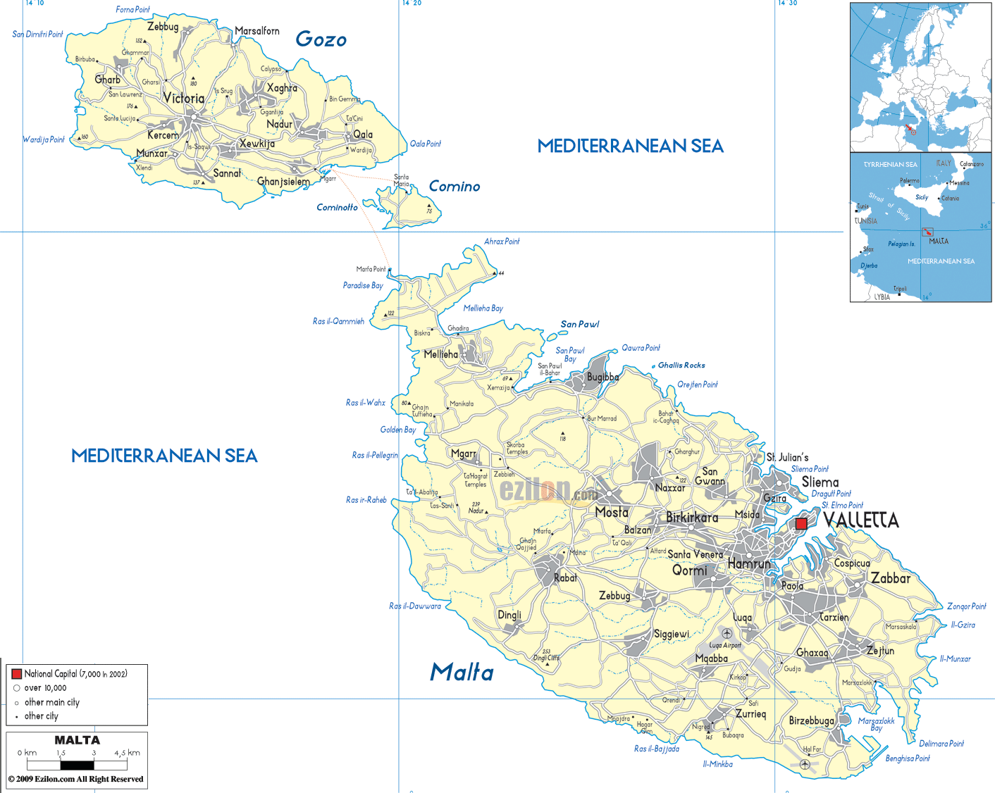
Description: Detailed large political map of Malta showing names of capital cities, towns, states, provinces and boundaries with neighbouring countries.

The map of Malta (Malta map with cities and towns) is a compact political map that is rich in information. Malta Gozo Comino Towns And Villages Map shows how Malta's main islands – Malta, Gozo, and the smaller island of Comino – are laid out and how towns, villages, and local councils are represented across the islands. The political map of Malta, with cities and towns, remains clear and easy to read because the islands are small, yet they allow many localities and road links to be displayed.
This Malta map with cities shows the national capital, Valletta, located on the eastern coast of the primary island. It also shows Sliema, St Julian's, Birkirkara, Qormi, Mosta, Rabat, Zejtun, Marsaxlokk, and Birzebbuga.
The capital of Gozo, Victoria (Rabat), and community areas such as Xaghra, Nadur, Marsalforn, Xlendi, and Gharb are marked, with the small Comino between them and Malta. The map of Malta, labeled with regions, shows the Mediterranean Sea to the south. An inset indicates Malta's position south of Italy and north of Libya.
Malta isn’t divided in states, rather the country is divided into local councils and statistical regions. A map of Malta with cities and regions shows clusters of urban locations around Valletta, Grand Harbor, and along the northern and southern coast.
On the map, the capital, Valletta, is shown with a distinct symbol and in bold lettering on a peninsula surrounded by fortifications and harbors. Located right next to each other are the historic "Three Cities" - Birgu (Vittoriosa), Bormla (Cospicua), and Senglea (Isla) along the Grand Harbor, forming one of Malta's densest neighborhoods.
The coastal towns of Sliema, Gzira, St Julian's, and Pembroke are shown on a layer of the Malta map to the north-west of Valletta. In contrast, inland, it shows communities such as Birkirkara, Mosta, Lija, Balzan, Qormi, and Zebbug, which make up much of the main island's central residential belt. Further North of Valletta, places such as Mellieha, St Paul's Bay, Bugibba and Qawra, and Marsaxlokk, Birzebbuga, and Zurrieq to the south, perfectly round off habitation around Malta's shore.
When you look at the map of Malta with cities and towns, you start from the north-west with Mellieha and St Paul's Bay and go down the coast past Bugibba and Qawra and reach the more urban central belt around Mosta, Birkirkara, Qormi, and Valletta.
If you start from Valletta, you could follow the shore down toward Marsascala, Marsaxlokk, and Birzebbuga. Overall, you can see how the main coastal roads link fishing villages, residential zones, and port facilities. You can take an inland route from Rabat and Mdina towards the central towns, then out again to the western cliffs near Dingli, all marked on the Malta map cities layer.
If you took a similar journey along the map of Malta with towns and villages, on Gozo, you would run from Mġarr harbor, through Victoria, and out to coastal villages like Xlendi, Marsalforn, and Xaghra. The pattern shows how Gozo's roads radiate from the central capital to the surrounding bays and headlands. As the islands are small, the map shows that the routes are quite close together. As such, residents and visitors can easily decide how long a trip will take and plan day trips accordingly.
Malta has no land borders; however, the map of Malta with cities and regions places Malta in the wider Mediterranean Sea. Inset maps mark distances to neighboring countries, such as 80 km to the south of Italy, 284 km to the east of Tunisia, and 333 km to the north of Libya, highlighting the archipelago's location along historical trade and migration routes. When planning your trip around Europe or the Mediterranean, a Map of Malta cities can show you flight and ferry connections with surrounding nations.
Despite its small size, the Map of Malta with towns and villages distinguishes larger cities from smaller towns and villages by the size of the symbol. The national capital, Valletta, is also one of Malta's UNESCO World Heritage cities.
The major localities are also marked with the labels of Birkirkara, Mosta, Qormi, Sliema, St Julian's, San Pawl il-Bahar, and Victoria (Gozo). Many little dots indicate numerous villages and local councils across Malta and Gozo, such as Zebbiegh, Gharghur, Ghajnsielem, Xaghra, and Gharb.
According to the hierarchy:
Residents can easily see where the larger service centers are located relative to their village.
Tourists will also be able to decide whether to opt for a central hub like Sliema or a quieter countryside locality.
Students can study how settlement patterns operate in a compact island state.
You can refer to this Map of Malta with cities and towns for better local reference, as it integrates localities, roads, harbors, and regional context. The residents can easily identify their town/village, see how they connect by road to Valletta and other important centers, and spot nearby coastal resorts or inland heritage sites such as Mdina.
Tourists can use the map of Malta's cities and regions to plan an itinerary that moves from Valletta to the Three Cities, Sliema, St Julian's, Marsaxlokk, Mdina, and Victoria in Gozo, with ferry crossings and bus routes clearly indicated on its layout.
The map of Malta with regions is a great case study for geography students on how a microstate manages multiple urban centers, tourist areas, and rural villages in a very small area. By using these educational political maps that omit the land's physical relief, the student's attention can be drawn to human geography themes such as local councils, population clustering, and transport corridors before the physical layers, such as geology or coastlines, are added.
Malta is located in the central Mediterranean Sea south of Italy and north of Libya.
The map shows the islands of Malta, Gozo, and Comino.
Valletta is shown as the national capital of Malta on the eastern coast of the main island.
Major cities and towns shown include Valletta, Sliema, St Julian's, Birkirkara, Qormi, Mosta, Rabat, Marsaxlokk, and Victoria.
Valletta is located on a fortified peninsula along Malta's eastern coastline beside the Grand Harbor.
Historic cities near Valletta include Birgu, Bormla, and Senglea, known together as the Three Cities.
Coastal towns northwest of Valletta include Sliema, Gzira, St Julian's, and Pembroke.
Central inland towns shown include Birkirkara, Mosta, Lija, Balzan, Qormi, and Zebbug.
Northern towns shown include Mellieha, St Paul's Bay, Bugibba, and Qawra.
Southern towns shown include Marsascala, Marsaxlokk, Birzebbuga, and Zurrieq.
Marsaxlokk is located on the southeastern coast of Malta beside a traditional fishing harbor.
Mdina is located inland in western-central Malta near Rabat.
Western localities shown include Dingli, Rabat, Mdina, and nearby countryside areas.
The map highlights coastal and inland transport corridors linking Valletta with Sliema, Mosta, Mellieha, Marsaxlokk, and other towns.
Roads are shown in a simplified road-light style connecting major towns, harbors, and villages.
Gozo towns shown include Victoria, Xaghra, Nadur, Marsalforn, Xlendi, and Gharb.
Victoria, also called Rabat, is located near the center of Gozo.
Mgarr harbor is located on the southeastern coast of Gozo and serves as the main ferry gateway.
The map shows roads radiating outward from Victoria toward coastal villages and bays across Gozo.
Comino is located between Malta and Gozo in the Mediterranean Sea.
No. Malta has no land borders because it is an island country in the Mediterranean Sea.
The map references Italy, Tunisia, and Libya as nearby neighboring countries.
The map indicates Malta is approximately 80 kilometers south of Italy.
The map uses larger labels and symbols for major cities while smaller villages appear with smaller dots and text.
Smaller villages shown include Zebbiegh, Gharghur, Ghajnsielem, Xaghra, and Gharb.
Valletta is important because it serves as Malta’s capital city and UNESCO World Heritage center.
Yes, travelers can use the map to plan routes between Valletta, Sliema, Mdina, Marsaxlokk, Gozo, and coastal resorts.
Yes, the map helps students study settlement patterns, transport corridors, local councils, and urban clustering in a microstate.
Yes, the map focuses on towns, regions, transport links, and human geography rather than physical terrain.
No. Printing or copying maps from this site is not permitted.

Physical Map of Malta
Physical map and map image of Malta.

Road Map of Malta
Road map and map image of Malta.

Regional Directory of United States of America
Information and guide about United States of America and websites with American topics.

Regional Directory of Europe
Information and guide about Europe and websites with European topics.

Regional Directory of Australia
Information and guide about Australia and websites with Australian topics.