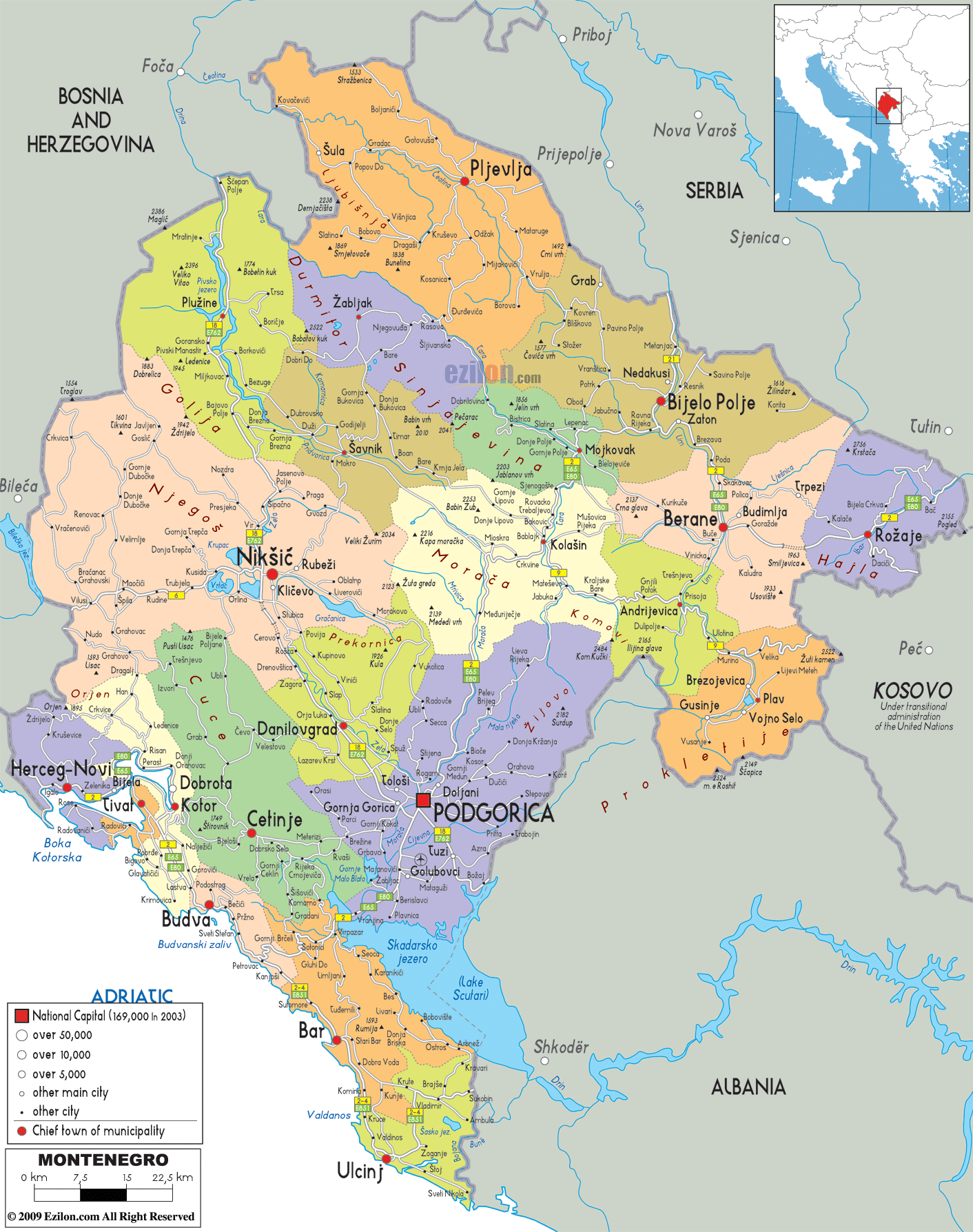
Description: Detailed large political map of Montenegro showing names of capital cities, towns, states, provinces and boundaries with neighbouring countries.
This map of Montenegro with cities, municipalities, and towns is already large enough to read directly on your desktop. To see a full-screen zoom view on a phone or tablet, tap the map image (or tap the Zoom Map label above the image). Scan by shading municipalities in various colored blocks, with Montenegro's cities and towns in bold.
 Detailed map of Montenegro with cities, towns, municipalities, villages and surrounding countries such as Croatia, Bosnia and Herzegovina, Serbia, Kosovo and Albania. Montenegro
is a country that lies in the Southeastern Europe. On
the southwest of the country lies the Adriatic Sea and
on its west, there is Croatia. Podgorica may be its
capital city and the largest city in the country, but
people consider Cetinje to be the royal capital city of
Montenegro.
Detailed map of Montenegro with cities, towns, municipalities, villages and surrounding countries such as Croatia, Bosnia and Herzegovina, Serbia, Kosovo and Albania. Montenegro
is a country that lies in the Southeastern Europe. On
the southwest of the country lies the Adriatic Sea and
on its west, there is Croatia. Podgorica may be its
capital city and the largest city in the country, but
people consider Cetinje to be the royal capital city of
Montenegro.
This nation has a service based market and as such, its economy is dependent on the service sectors. The service sector made up about 3/4th of the country’s GDP in the year 2007.
Most of the industries in Montenegro consist of agricultural processing, steel production and aluminum production. The tourism industry is also very vital to the economy of the country.
As Montenegro has mountainous northern region and scenic coast, it is a great place for the growth of different types of tourism. The country gets many tourists from all over the world.
In the year 2007, it was found that about one million tourists visited the country. This is the reason why the country is depending on tourism for future economic development.
The economy is too dependent on foreign investments and it is because of this that it is vulnerable to external shocks. In addition to this, the country also has a high import/export deficit.

Physical Map of Montenegro
Physical map and map image of Montenegro.

Road Map of Montenegro
Road map and map image of Montenegro.

Regional Directory of United States of America
Information and guide about United States of America and websites with American topics.

Regional Directory of Europe
Information and guide about Europe and websites with European topics.

Regional Directory of Australia
Information and guide about Australia and websites with Australian topics.