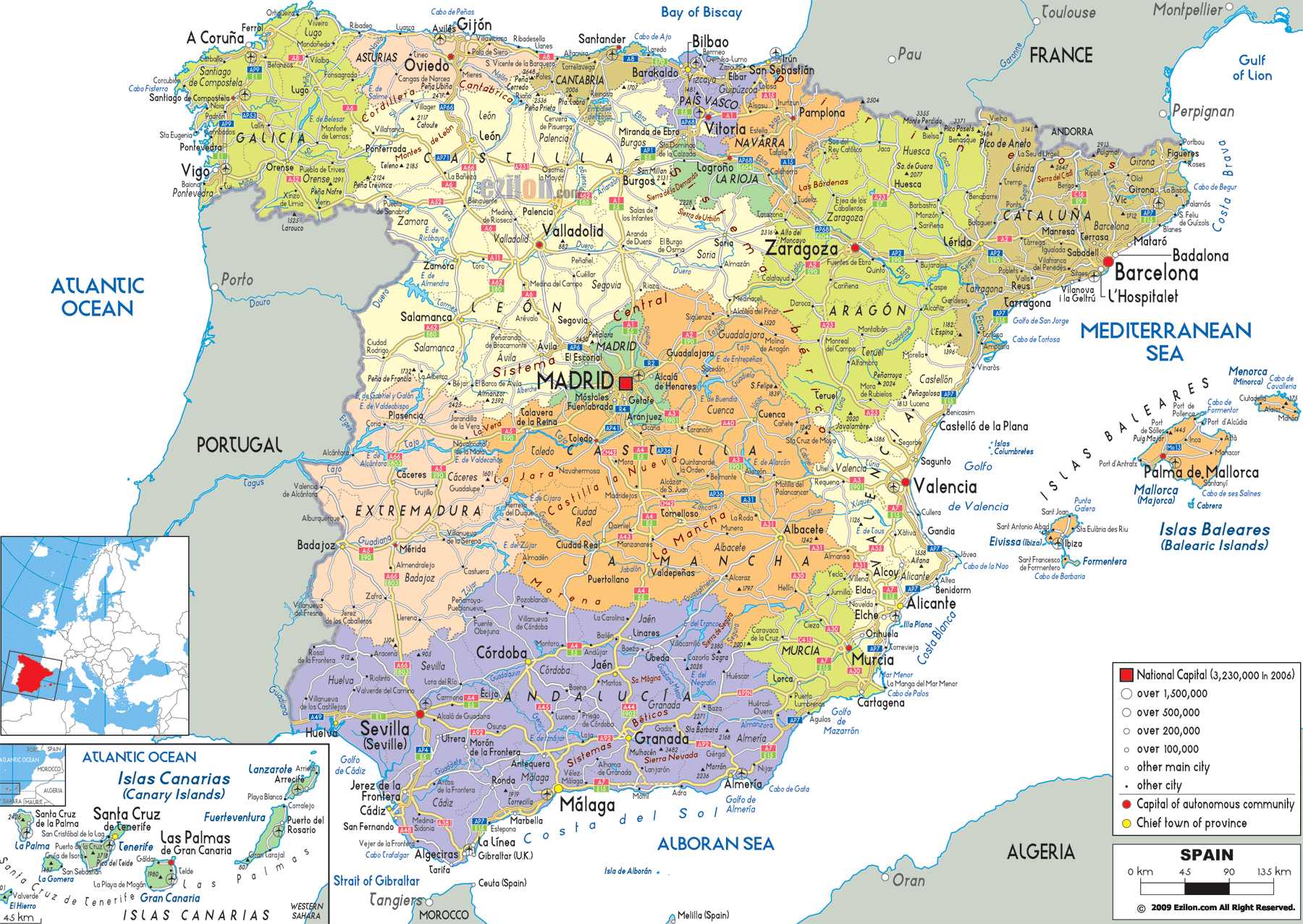
Description: Detailed large political map of Spain showing names of capital cities, towns, states, provinces and boundaries with neighbouring countries.
 Detailed map of Spain with cities, towns, autonomous communities, villages and surrounding countries France, Andorra and Portugal. The political map of Spain reveals a fascinating interplay of Spain provinces map details, Spain administrative divisions, and intricate Spain political boundaries. As the largest country on the Iberian Peninsula map, Spain's layout blends historical kingdoms, diverse landscapes, and a rich tapestry of local governance.
Looking at a map of Spain above with cities and provinces, one immediately notices the defined Spain regions and provinces - 17 autonomous communities and two autonomous cities, each with a distinct personality. These Spain political features are not merely lines on paper; they are expressions of centuries of history, cultural shifts, and geographical necessity.
For travellers, the Spain travel map is also an invitation. This is a Spain geography guide that will lead you through mountain chains, coasts, fertile plains, and urban hubs. Whether you're studying Spain provincial capitals for an assignment or planning Spanish tourist destinations for a road trip, this journey through the country's provinces will enlighten you.
The Spain Andorra border is a small yet apparent boundary in the Pyrenees that is a mountain range, separating Spain from France. To the north, Spain and France border map further highlight the European borders. The border of Spain and Portugal extends across the rural plateaus and river valleys to the west. In the south, the Spain Gibraltar border marks a unique British overseas territory, while the Spain Morocco connection through Ceuta and Melilla on the African coast underscores Spain's historical maritime reach.
Surrounding waters are equally important to Spain's political and travel map identity. The Mediterranean Sea Spain coast curves along the eastern and southern shores, rich with Spanish coastal cities like Barcelona, Valencia, and Málaga. The Atlantic Ocean Spain coast touches Galicia in the northwest, while the Bay of Biscay coastline meets the Basque Country and Cantabria.
In the far northwest, Galicia occupies a green and rugged corner of the Spain political map. Its provincial breakdown includes A Coruña, Lugo, Ourense, and Pontevedra. Known for its Celtic heritage, Galicia's Spain provincial capitals - like Santiago de Compostela are pilgrimage destinations and Spanish tourist destinations in their own right.
A major port and cultural centre on the Atlantic Ocean Spain coast, A Coruña is also part of the province of Galicia. Lugo lies on the same coast and is noted for having completely intact several miles of Roman walls. The province of Pontevedra is strewn with the Rías Baixas estuaries which are famous for their seafood and Albariño wine. The lucky people of Ourense are enjoying thermal springs.
Travel east along the Bay of Biscay coastline, and Asturias emerges—a lush, mountainous province capitalized at Oviedo. Known for dramatic cliffs and fishing towns, it is one of the Spanish coastal cities regions where the Cantabrian Mountains meet the sea.
From Gijón's industrial port to Cudillero's colorful houses, Asturias reflects the blend of working harbors and tourist charm. On a detailed map of Spain with regions, Asturias stands out as both a cultural and natural stronghold.
Cantabria is a compact yet diverse part of the Spain geography guide. Santander, its provincial capital, has golden beaches and elegant promenades. Inland, the Picos de Europa National Park draws hikers and nature lovers, making it a prime Spanish tourist destination.
The province’s political boundaries are framed by Asturias to the west and the Basque Country to the east, both visible on a Spain political and travel map.
The Basque Country’s Spain provincial breakdown includes Álava, Biscay, and Gipuzkoa. Each is distinct: Bilbao in Biscay is a global design city, while San Sebastián in Gipuzkoa offers world-class cuisine along the Bay of Biscay coastline.
Vitoria-Gasteiz, Álava’s capital, is a planned city with medieval roots. The political regions of Spain explained often cite the Basque Country as an example of strong regional identity and autonomy.
Nestled against the Spain and France border map, Navarre stretches from the Pyrenees down to the Ebro Valley. Pamplona, its capital, is famous for the Running of the Bulls. The province’s Spain political features combine highland fortresses with fertile farmland.
Navarre’s position along the Iberian Peninsula map has made it a crossroads for pilgrims, traders, and armies throughout history.
Aragon, with its provinces of Zaragoza, Huesca, and Teruel, dominates a large inland section of the Spain provinces map. Zaragoza is the capital and cultural heart, while Huesca’s Pyrenean peaks lure adventurers. Teruel, often overlooked, offers Mudéjar architecture recognized by UNESCO.
On a Spain road and political map, Aragon’s highways link the Pyrenees to the Mediterranean coast, revealing its strategic role.
Catalonia’s Spain administrative divisions include Barcelona, Girona, Lleida, and Tarragona. Barcelona, a major Spanish tourist destination, sits along the Mediterranean Sea Spain coast and anchors the region economically and culturally.
Girona preserves medieval walls, Lleida stretches into agricultural plains, and Tarragona combines Roman ruins with seaside resorts. The Spain political boundaries here reflect both historic independence movements and modern governance.
Moving south along the Mediterranean Sea Spain coast, the Valencian Community comprises Valencia, Alicante, and Castellón.
Valencia city, a major city in Spain, blends Gothic cathedrals with futuristic architecture. Alicante is a sunny hub for beach tourism, while Castellón offers orange groves and mountain villages.
On a Spain travel map, this region is a prime spot for those exploring Spain cities to visit along the eastern shoreline.
Further south lies Murcia, a single-province autonomous community. Murcia city is an inland capital with Baroque architecture, while its coastal stretch - Costa Cálida - hosts warm beaches and fishing ports.
Seen on a complete guide to Spain’s political divisions, Murcia bridges Valencia’s fertile plains with Andalusia’s rugged east.
Andalusia is the largest autonomous community on the Spain provinces map, stretching from the Atlantic Ocean Spain coast in Huelva to the Mediterranean Sea Spain coast in Almería. Its eight provinces—Seville, Málaga, Cádiz, Granada, Córdoba, Jaén, Huelva, and Almería—form a region where Moorish palaces, flamenco rhythms, and sun-drenched beaches coexist.
Seville, the capital, is an architectural jewel with the Giralda tower and the Alcázar. Málaga, one of the Spanish coastal cities, is a gateway to the Costa del Sol, while Cádiz, facing the Spain Morocco connection across the Strait of Gibraltar, blends colonial history with golden sands.
Inland, Granada lies beneath the snow-capped Sierra Nevada, home to the Alhambra. Córdoba has a Moorish mosque and Jaén has olive groves. Huelva opens out on an Atlantic fishing bounty and Almería is a desert much loved by filmmakers.
Andalusia is linked by motorways from its coastal resorts to inland provincial capitals, and these motorways, shown on a Spain road and political map, testify to the region’s dynamic history and tourist appeal.
Castile and León is the largest autonomous community in Spain by area, visible on any detailed map of Spain with regions. It is made up of nine provinces: Ávila, Burgos, León, Palencia, Salamanca, Segovia, Soria, Valladolid, and Zamora.
Its Spain political boundaries border Portugal to the west and multiple Spanish regions to the east and south. Valladolid, the capital, sits at the heart of the region, while Burgos boasts Gothic cathedrals. Salamanca, a Spanish tourist destination, houses one of Europe’s oldest universities.
León preserves Roman walls, Segovia is famous for its aqueduct, Ávila for its fortress walls, and Soria for its natural parks. Zamora and Palencia feature Romanesque churches and agricultural heritage.
Bordering the Spain and Portugal border, Extremadura is made up of Cáceres and Badajoz. Both provinces feature a mix of medieval towns and natural reserves. Cáceres’ walled old town is a UNESCO site, while Badajoz faces directly toward Portugal, a reflection of centuries of frontier history.
Extremadura’s location on the Iberian Peninsula map made it a launching point for conquistadors during the Age of Exploration.
Castile-La Mancha’s five provinces - Albacete, Ciudad Real, Cuenca, Guadalajara, and Toledo - spread across the central plateau. On a Spain political and travel map, this region surrounds Madrid like a protective frame.
Toledo, the historic capital, is a museum of Christian, Jewish, and Moorish architecture. Cuenca is known for its hanging houses, Ciudad Real links to Don Quixote’s La Mancha plains, Guadalajara connects to the central highlands, and Albacete serves as an agricultural hub.
Madrid, both a province and Spain’s national capital, is marked prominently on any map of Spain with cities and provinces. Its urban sprawl blends royal palaces, grand boulevards, and modern business districts.
For travellers, Madrid is a hub for exploring Spain cities to visit across the peninsula. Its highways and railways radiate like spokes on a wheel, visible on a Spain road and political map.
While La Rioja is small, it is a vital Spain geography guide entry due to its vineyards and historic monasteries. Logroño, the capital, lies on the Camino de Santiago route. The province’s fertile plains contrast sharply with surrounding mountains.
Navarre has already been mentioned in the Pyrenean section, but its lowlands are equally important for agriculture and cross-border trade.
The Balearic Islands travel guide section on a Spain political map shows Mallorca, Menorca, Ibiza, and Formentera as a single autonomous community in the Mediterranean Sea Spain coast zone.
Mallorca’s capital, Palma, blends beaches with Gothic architecture. Menorca is quieter, with prehistoric monuments. Ibiza is world-famous for nightlife, while Formentera offers unspoiled shores. These islands are among the top Spanish tourist destinations in any Spain travel map itinerary.
The Canary Islands political map places them off the northwest coast of Africa, yet politically they are Spanish. The archipelago includes Tenerife, Gran Canaria, Lanzarote, Fuerteventura, La Palma, La Gomera, and El Hierro.
Tenerife’s Santa Cruz and Gran Canaria’s Las Palmas are bustling capitals. Lanzarote and Fuerteventura are known for volcanic landscapes and windsurfing beaches. The islands hold strategic Atlantic shipping points and are vital for tourism.
On a Spain administrative divisions chart, the country’s geopolitical outline includes the Spain and Portugal border to the west, the Spain and France border map and Spain Andorra boundary to the north, the Spain Gibraltar border in the south, and the Spain Morocco connection via Ceuta and Melilla.
The Bay of Biscay coastline in the north, the Mediterranean Sea Spain coast to the east and south, and the Atlantic Ocean Spain coast to the west and southwest provide maritime trade and naval access.
This complete guide to Spain’s political divisions has taken us province-by-province, from the Basque mountains to the Andalusian plains, from the Bay of Biscay coastline to the volcanic slopes of the Canary Islands.
The understanding of Spain’s political geography is crucial for both academic study and real-world travel planning. Each province tells a story - of historical kingdoms, natural landscapes, and evolving identities - visible in every border line and capital dot on the Spain provinces map.
Whether you are following a province-by-province guide to Spain for a cultural immersion, consulting a detailed map of Spain with regions for research, or crafting your own Spain political and travel map for an upcoming trip, the political features of Spain offer endless fascination.
From major cities in Spain to hidden inland gems, from bustling Spanish coastal cities to remote island villages, the Spain provincial breakdown is not just geography - it is a narrative of a nation that continues to shape the Iberian Peninsula.

Physical Map of Spain
Physical map and map image of Spain.

Road Map of Spain
Road map and map image of Spain.

Regional Directory of United States of America
Information and guide about United States of America and websites with American topics.

Regional Directory of Europe
Information and guide about Europe and websites with European topics.

Regional Directory of Australia
Information and guide about Australia and websites with Australian topics.