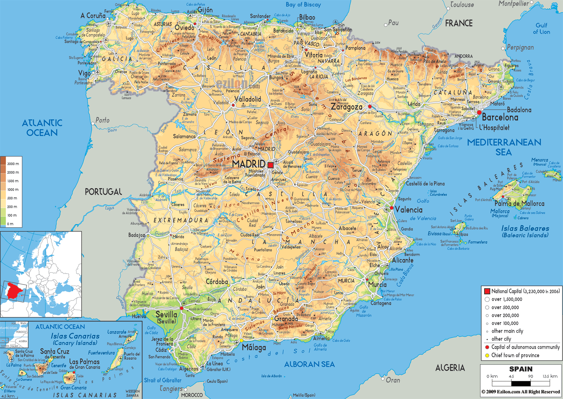
Description: The physical map of Spain showing major geographical features like elevations, mountain ranges, seas, lakes, plateaus, peninsulas, rivers, plains, landforms and other topographic features.
 Spain's physical map above is quite interesting. It has mountain ranges, plains, rivers, valleys, and coastlines. The Pyrenees of northern Spain are home to snow-capped peaks and the volcanic summits of the Canary Islands are hidden in the Atlantic Ocean. This Spain geography guide will take you on a journey through each province of the Iberian peninsula.
Not only that, but it will also include the Mediterranean Sea’s Balearic Islands. Also not to forget, the Canary Islands which are located off the northwest Africa coast. Students studying the map of Spain with cities and provinces, travellers charting the route, geography hounds - whoever you may be, this deep-dive will give you an unparalleled understanding of Spain’s physical features.
Spain occupies most of the Iberian Peninsula, sharing borders with Portugal to the west, France and the small principality of Andorra to the northeast, and the British Overseas Territory of Gibraltar to the south. Across the Strait of Gibraltar lies Morocco, separated by just 14 kilometres of water. Spain’s coastline stretches for thousands of kilometres along both the Atlantic Ocean and the Mediterranean Sea, giving the country a distinctive maritime identity.
The Bay of Biscay coastline in the north is known for its rugged cliffs and pounding surf, while the Mediterranean coast enjoys sandy beaches, sheltered coves, and warm turquoise waters. The country lies in between two oceans; its geographical diversity is further enhanced by its location and varied topography which, in turn, influences climate, agriculture and regional culture.
The physical map of Spain reveals four major natural divisions:
The Northern Mountains – dominated by the Pyrenees and Cantabrian ranges.
The Central Plateau (Meseta Central) – a high plain surrounded by mountains.
The Southern Mountain Ranges – including the Sierra Morena and Sierra Nevada.
The Coastal Plains and Islands – from the Mediterranean coast to the Atlantic shores and offshore territories.
In the far northeast, the Pyrenees Mountains form a dramatic natural barrier between Spain and France. This chain extends from the Bay of Biscay in the west to the Mediterranean Sea in the east. On the Spain and France border map, you can see how this formidable wall of granite and limestone peaks reaches altitudes over 3,000 metres, with Aneto Peak (3,404 m) being the highest.
Hikers will find some of Spain's most beautiful trails in the Pyrenees, while students will appreciate how political borders often follow the lines of nature. The slopes and summits of these mountains are covered in snow in winter and the rivers Segre and Noguera Pallaresa, which are fed by these mountain waters, flow into the river Ebro basin.
Moving west from the Pyrenees along the north coast, the Cordillera Cantábrica (Cantabrian Mountains) runs parallel to the Bay of Biscay coastline. This region is marked by steep valleys, green meadows, and dramatic limestone cliffs. The range includes Picos de Europa National Park, a protected area known for jagged peaks like Torre de Cerredo (2,650 m).
The physical map of Spain shows that both the Cantabrian Mountains and the Iberian mountains act as climatic divides. Indeed, the northern slopes of the former receive plenty of rainfall which helps forests to flourish. Further south, the slopes descend into the drier Meseta Central. Towns like these, Oviedo and Santander, sitting between the mountain and the sea, has access to the maritime and good land.
In the northwest, the Galician Massif forms a rugged highland area that slopes toward the Atlantic Ocean. The coastline of Galicia is heavily indented by rías (drowned river valleys), which provide natural harbours for fishing and commerce. The cities of A Coruña, Vigo, and Santiago de Compostela are very important.
From the Iberian Peninsula map, it is clear that Galicia is separated from central Spain by the Cantabrian Mountains and the León Mountains, making it historically more connected by sea than land. The Miño River, one of Galicia's lifelines, flows from the Cantabrian slopes into the Atlantic at A Guarda, marking part of the border with Portugal.
The Meseta Central is one of the defining features of Spain’s physical geography. This vast high plateau, averaging 600 to 700 metres above sea level, covers much of inland Spain. Divided into the Northern Meseta and Southern Meseta by the Sistema Central mountains, it is a land of rolling plains, cereal fields, and scattered sierras.
From the Spain provincial capitals perspective, major cities such as Madrid, Valladolid, Salamanca, Toledo, and Ciudad Real are located here. The climate is continental, with hot summers and cold winters, making irrigation crucial for agriculture.
The Sistema Central mountain range runs roughly east-west across the middle of Spain, splitting the Northern and Southern Mesetas. Its peaks, such as Pico Almanzor (2,592 m), are snow-capped in winter and attract hikers in summer.
The Sistema Central is very important because this mountain range has many rivers whose waters are the source of the Tagus and the Duero. On a physical map of Spain, information on the Sierra de Guadarrama is presented with the magnificent site appearing as a jagged backbone between Madrid and the western border with Portugal.
Several of Spain's most important rivers flow through the Meseta Central:
Duero River – rising in the Picos de Urbión in Soria, flowing west into Portugal before emptying into the Atlantic at Porto.
Tagus River – the longest river in the Iberian Peninsula, crossing Spain and Portugal to reach Lisbon.
Guadiana River – defining part of the Spain–Portugal border before reaching the Gulf of Cádiz.
The way of life of the people from the river valleys have made a huge impact on how settlements get established in different regions.
Moving eastward from the central plateau, we encounter the Ebro River Basin, one of the most significant lowland areas visible on the Spain physical and travel map. The Ebro River begins in the Cantabrian Mountains and flows southeast to the Mediterranean Sea at the Ebro Delta in Catalonia.
The basin is flanked by mountain ranges: the Sistema Ibérico to the south and the Pyrenees to the north. Useful effective precipitation, this geography creates a sheltered corridor with fertile soils for the growth of cereals, olives and grapes. The Zaragoza city thrives here due to agriculture and location on major transport routes.
Along the northeastern coast, Catalonia has mountains and cliffs on one side, beaches in the centre and plains on the other. Costa Brava is known for its rocky coves and fishing villages while Costa Daurada is famed for its golden sands.
On the Mediterranean Sea Spain coast, key urban centres include Barcelona, a major Mediterranean port city framed by the Serra de Collserola, and Tarragona, known for its Roman heritage. Inland, the Montseny and Montserrat mountain ranges rise steeply, visible on the map as clusters of rugged terrain between the sea and the Ebro basin.
East of mainland Spain, the Balearic Islands are marked on the map as a scattered group in the Mediterranean Sea. This Balearic Islands travel guide segment includes the four main islands: Mallorca, Menorca, Ibiza, and Formentera.
Mallorca features the Serra de Tramuntana, a UNESCO World Heritage mountain range running along its northwest coast.
Menorca is lower in elevation but surrounded by a fringe of turquoise coves.
Ibiza and Formentera belong to the Pityusic group, with hilly interiors and stunning beaches.
Geographically, the Balearics are a natural extension of the Iberian Peninsula’s mountain systems, submerged during ancient geological periods.
The Sierra Morena mountain range stretches east-west, forming a natural boundary between the Southern Meseta and Andalusia. This range is not as high as others but creates a clear topographic and climatic division. Towns such as Córdoba lie just south of the range, benefiting from fertile river valleys like the Guadalquivir.
The Guadalquivir River flows from the Sierra de Cazorla in Jaén province westward to the Atlantic Ocean at Sanlúcar de Barrameda. This valley is one of Spain's most productive agricultural regions, producing olives, citrus fruits, and cereals.
Major cities in the valley include Seville, Córdoba, and Jaén. The map shows how this fertile corridor cuts through otherwise mountainous Andalusia, linking inland provinces to the coast.
In the province of Granada, the Sierra Nevada rises dramatically, home to the highest peak in mainland Spain, Mulhacén (3,479 m). Snow covers these peaks in winter, and the range is a hub for skiing, hiking, and nature tourism.
The physical map shows the Sierra Nevada as a high-rise that is located just inland to the Mediterranean coast, while also sharply affecting the coast's-surface height and rainfall behaviour.
Andalusia’s coastline stretches from the Costa del Sol on the Mediterranean to the Costa de la Luz on the Atlantic. The Mediterranean city of Málaga and the other metropolis of Almería on the Atlantic side Cádiz and Huelva.
The Strait of Gibraltar on Spain and Morocco link map is a stretch of water. It reconstructs two continents, Europe and Africa. Gateway between continents, Algeciras is a port city in Spain.
The Canary Islands are an autonomous community of Spain that is volcanic in nature and located off the north west coast of Africa. The Canary Islands political map shows the seven main islands: Tenerife, Gran Canaria, Lanzarote, Fuerteventura, La Palma, La Gomera, El Hierro.
The largest island, Tenerife, is dominated by Mount Teide (3,718 m), the highest point in Spain and the third-highest volcanic structure in the world. The island's terrain includes lush northern valleys, arid southern slopes, and high-altitude volcanic deserts.
Gran Canaria has a mix of green highlands and desert-like south coasts.
Lanzarote and Fuerteventura are drier, with extensive sand dunes and lava fields.
La Palma, La Gomera, and El Hierro are smaller but mountainous, offering deep ravines and lush forests.
Due to the trade winds and the volcanoes' effects, these islands have unique microclimates.
Besides the rivers that we have studied, the physical map of Spain shows other important rivers:
Ebro – northeastern drainage to the Mediterranean.
Guadalquivir – southern flow to the Atlantic.
Júcar and Segura – eastern rivers providing irrigation for Mediterranean agriculture.
Spain’s coasts vary dramatically:
Bay of Biscay – rugged cliffs and deep estuaries.
Mediterranean – long sandy beaches and sheltered bays.
Atlantic (southwest) – wide beaches and tidal estuaries.
These coastlines influence settlement, tourism, and fishing industries.
Understanding Spain's physical geography helps in many ways:
Students can link natural features to historical and economic development.
Travellers can plan routes based on mountains, rivers, and coasts.
Planners and conservationists can protect unique ecosystems.
From the Iberian Peninsula map to the Canary Islands political and physical details, Spain's landscape is a blend of rugged highlands, fertile valleys, and vibrant coasts that make it both a geographical study wonder and a traveller's paradise.

Political Map of Spain
Political map and map image of Spain.

Road Map of Spain
Road map and map image of Spain.

Regional Directory of United States of America
Information and guide about United States of America and websites with American topics.

Regional Directory of Europe
Information and guide about Europe and websites with European topics.

Regional Directory of Australia
Information and guide about Australia and websites with Australian topics.