Description: Detailed large political map of Antigua showing cities, towns, 7 Parish or Provinces (St. Johns, St. George, St. Peter, St. Paul, St. Mary and Saint Philip. Island around this country is also indicated in the map.
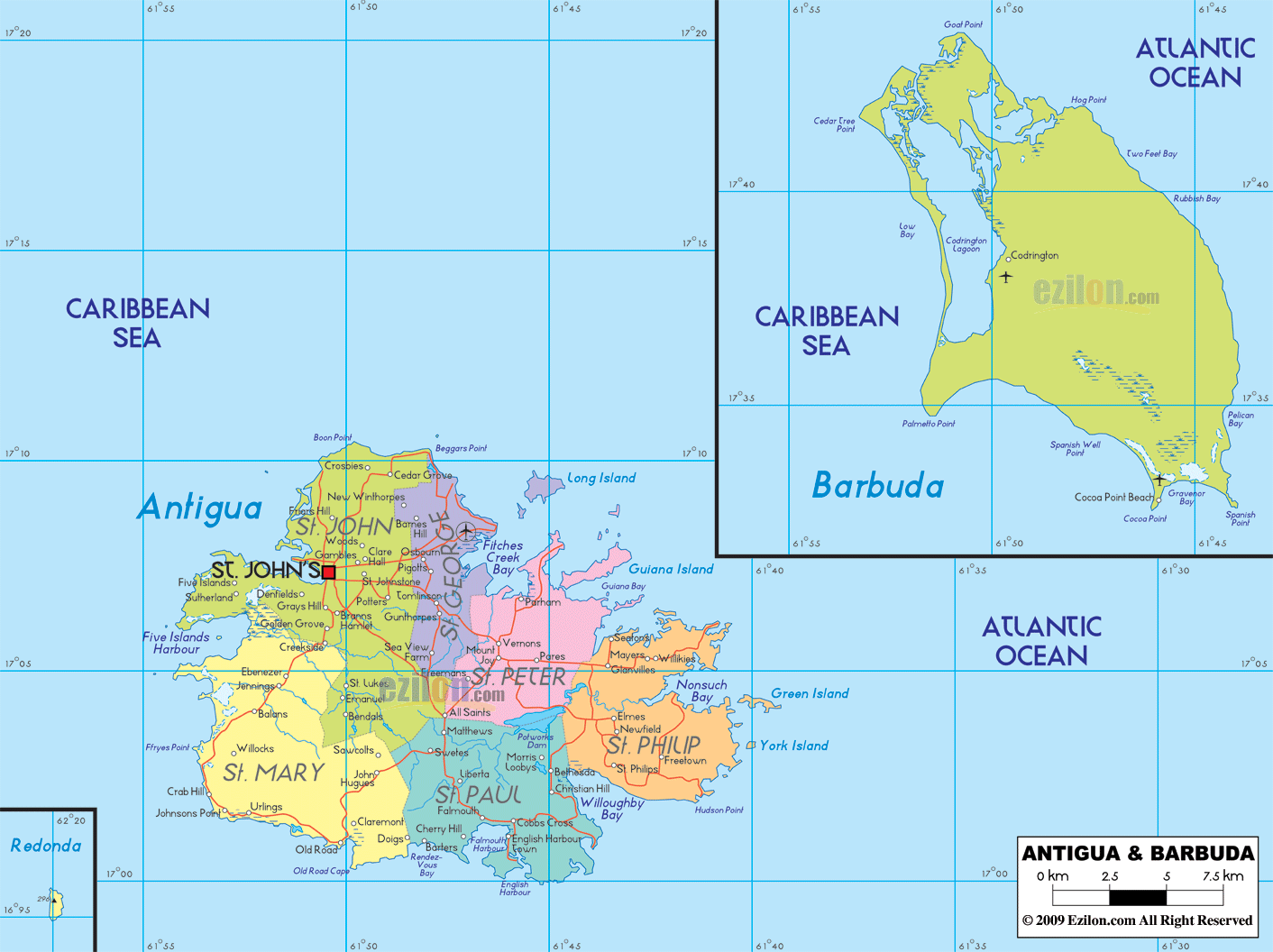
 This Map of Antigua & Barbuda is a detailed map that foregrounds the islands’ political divisions, primary settlements, harbors, and coastal features. It shades all six parishes on Antigua and shows Barbuda separately with its main town Codrington. The national capital St. John’s is easy to spot on Antigua’s northwest coast. A road-light design keeps the focus on parishes and towns while still letting the eye follow shoreline travel corridors and short inland connections. The surrounding labels anchor orientation in the Caribbean Sea and the Atlantic Ocean. For learners, residents, and travelers, it functions like a best map: uncluttered, legible, and accurate.
Antigua is the larger of the two populated islands and sits at roughly 17 degrees north latitude, ringed by bays and barrier reefs. To the north-northwest lies Barbuda, flatter and reef-fringed with a famous lagoon beside Codrington. Farther west appears tiny Redonda, a rocky dependency. Neighboring countries do not crowd this sheet, which keeps attention on the national picture, but the setting is within the northeastern Caribbean between the Virgin Islands arc and the Windward chain.
Antigua and Barbuda is a twin island country in the Lesser Antilles. The national capital St. John’s sits on the northwest coast of Antigua around a protected harbor. On a clear political map, St. John’s is the largest label on Antigua’s west side. Codrington is the main town on Barbuda.
The country includes Antigua, Barbuda, and the tiny Redonda islet. Antigua lies between the Caribbean Sea on the leeward side and the Atlantic Ocean on the windward side. Nearby neighbors by sea are St. Kitts and Nevis to the northwest, Montserrat to the southwest, and Guadeloupe to the south. Antigua’s highest point is Boggy Peak in the Shekerley Hills. Barbuda is mostly flat with long beaches and a large lagoon.
Antigua is divided into six parishes. Learning these names makes scanning any Antigua and Barbuda map fast:
Saint John around St. John’s
Saint George northeast of the capital toward the airport
Saint Peter on the north and east shores
Saint Philip on the far east and southeast
Saint Paul on the south coast including English Harbour
Saint Mary on the southwest coast
Barbuda is administered as a dependency with Codrington as its center.
On Antigua
St. John’s: capital, Heritage Quay and Redcliffe Quay cruise piers, Fort James and Deep Bay near the harbor entrance
Cedar Grove, Dickenson Bay, Runaway Bay: north coast beach area just north of the capital
Five Islands Village and Galley Bay: west of St. John’s along quiet coves
Jolly Harbour, Jolly Beach, Bolans, Darkwood Beach, Ffryes Beach: southwest coast resort strip
Old Road and Carlisle Bay: sheltered bay on the south west bend
Liberta and All Saints: inland towns that anchor cross island routes
English Harbour and Falmouth: south coast yachting centers with Nelson’s Dockyard and Shirley Heights
Bethesda, Seatons, Willikies, Half Moon Bay: east coast communities and beaches
Parham and Parham Harbour: north east historical port on North Sound
Offshore islets often labeled on detailed maps: Great Bird Island, Long Island also called Jumby Bay, Green Island, Maiden Island
On Barbuda
Codrington: main settlement on the lagoon
Two Foot Bay, Palmetto Point, Spanish Point, Cocoa Point: coastal landmarks around the island’s rim and beaches
West and northwest Antigua: calm Caribbean water with wide beaches near Dickenson Bay, Jolly Beach, and Ffryes Beach
South Antigua: hill backed bays from Carlisle Bay to English Harbour and Falmouth Harbour
East Antigua: Atlantic side with pocket bays such as Half Moon Bay and Nonsuch Bay near Green Island
Shekerley Hills: low range along the south and southwest with Boggy Peak as the island high point
Barbuda: long sand beaches, a broad Codrington Lagoon, and reef lined shores
A general map shows Antigua’s road skeleton without many route numbers. Use these town chains to read it quickly:
North coast belt: St. John’s to Cedar Grove to Dickenson Bay to Hodges Bay
West and southwest ribbon: St. John’s to Five Islands to Jolly Harbour to Bolans to Old Road
South cross link: All Saints to Liberta to Falmouth and English Harbour
East coast arc: All Saints to Bethesda to Seatons and Willikies then south to Half Moon Bay
Airport approach: St. John’s northeast to V. C. Bird International Airport through Saint George parish
On Barbuda, a simple spine road connects Codrington with beaches and the airstrip, with sandy tracks toward Palmetto Point and Spanish Point.
V. C. Bird International Airport sits northeast of St. John’s near Coolidge
St. John’s Deep Water Harbour handles cruise ships and cargo
English Harbour and Falmouth Harbour are major marinas for yachts
Barbuda Codrington Airport connects the sister island by air
The Barbuda Express ferry links St. John’s and Codrington across the channel, with schedules that vary by season
Language: English is official and widely spoken
Currency: Eastern Caribbean dollar (XCD), with US dollars commonly accepted in tourism areas
Time zone: UTC minus 4 hours year round
Driving: left side of the road. Roundabouts are common near the capital and airport
Power: mostly 230 V, 60 Hz. Plugs A and B are common in hotels, and Type G British outlets also appear. Carry a universal adapter
Calling code: +1 268
Emergency: 911 connects to police, fire, and ambulance
Tropical maritime climate. Drier months are often December to April. Wetter months are usually June to November with hurricane risk peaking late summer into early autumn. Sea conditions are calmer on Antigua’s west side and rougher on the east Atlantic edge. On Barbuda, check local advice before lagoon crossings and reef passes.
Fix St. John’s to anchor the northwest of Antigua
Mark English Harbour and Falmouth to understand the south coast shape
Trace the beach line from Dickenson Bay down to Jolly Harbour and Darkwood for the west coast
Use Half Moon Bay, Nonsuch Bay, and Green Island to picture the east coast
On Barbuda, set Codrington by the lagoon, then add Two Foot Bay and Cocoa Point to outline the north and south ends
Antigua is neatly divided into six parishes. From any classroom or planning meeting, you can use this Antigua & Barbuda map with cities to walk parish by parish east to west and north to south.
Saint John wraps Antigua’s capital region. St. John’s occupies the deep natural harbor on the northwest coast. Around it the map names urban and suburban communities such as Potters, Cedar Grove, Gray’s Hill, Bendals, and Five Islands Village near Five Islands Harbour. North-shore beaches and inlets like Deep Bay and Runaway Bay fall within easy reach of the city grid. Because parish shading is bold, it is simple to see how Saint John touches every other parish except Saint Philip.
Saint Mary spreads across the island’s southwest. Coastal settlements include Old Road and Urlings, with interior villages such as Jennings and Bolvans shown near the main west-coast corridor. Morris Bay and the nearby headlands give Saint Mary a scenic line that travelers commonly follow in a north-south coastal drive. The parish meets Saint John to the north, Saint Paul to the east, and opens toward the Caribbean on its west and south edges.
Saint Paul centers on Antigua’s south shore. Two names stand out for sailors and heritage travelers: English Harbour and Falmouth. The pair form a double-harbor complex framed by Nelson’s Dockyard and hills that shelter yachts; on this political map the harbors appear as a paired indentation with towns labeled cleanly at the waterline. Inland you see Liberta, Piccadilly, and Bethesda at the parish borders, which tells you there is a populated corridor between the maritime historic sites and the east-coast bays.
Saint Philip holds Antigua’s entire east arm, facing the open Atlantic Ocean. The shoreline is scalloped by Nonsuch Bay, Willoughby Bay, and smaller inlets. The map points to Willikies, Newfield, Freetown, and Seatons along the east-coast arc. Offshore lies Green Island at the mouth of Nonsuch Bay and the paired barrier of York Island; farther north you can pick out Great Bird Island and Guiana Island guarding the infilled north-coast lagoons. Because the parishes are color-separated, Saint Philip’s reach across multiple bays is obvious at a glance.
Saint Peter occupies Antigua’s northeast, a bridge between the Atlantic-facing Saint Philip and the northern parishes. The anchor town is Parham, long known for Parham Harbour and its classic church. Inland you can follow the map labels to Pares, Glaville’s, and small villages threading toward the Saint George line. Offshore, the parish fronts on a maze of mangrove islets and reefs that create calm inner waters from Fitches Creek Bay around to Long Island.
Saint George, just east of St. John’s, contains suburban clusters and villages that feed the capital’s economy. Potters Village and Pigotts typically appear on detailed sheets; in this rendering you can see the parish shading pressed up against Saint John, Saint Peter, and Saint Philip, which suggests how roads knit the urban rim to the east-coast harbors. The parish’s north boundary tips toward Cedar Grove and the coastal indentation at Hodges Bay on some editions; on this sheet your eye can still trace the continuity from St. John’s to the airport corridor.
This map’s precision with nearshore features is immensely helpful. On the north and northeast you will spot Great Bird Island, Guiana Island, and Long Island resting inside a shallow platform that protects Parham Harbour and Fitches Creek Bay. On the east, Green Island and York Island define the mouth of Nonsuch Bay. To the south, Willoughby Bay and the notch of English Harbour are like a compass for the Saint Paul shoreline. To the west, Five Islands Harbour lies a short skip from St. John’s. Every one of those names is a natural navigation cue even when the page stays road-light.
In the inset, Barbuda is shown with clear coastal names and a single urban label: Codrington. The settlement sits beside the long Codrington Lagoon that dominates the island’s western half. The map names Spanish Point on the southeast, Palmetto Point on the west, Hog Point and Cedar Tree Point in the north, plus Coco Point Beach in the south. Around the rim you can read River and Low Bay. Barbuda’s flatness and reef line are implicit in that neat outline. Though the island has few roads, the town-to-beach spacing hints at short transfers along the leeward shore.
At the lower left a small box references Redonda, the uninhabited rocky islet southwest of Antigua. Its inclusion is a reminder that the state is a three-island nation even though the population and services concentrate on Antigua and Barbuda.
Antigua’s roads circle the coast and cut short inland chords between parishes. Even without numbered highways, the place names make travel logic clear. Think St. John’s to Five Islands Harbour, south to Old Road and Urlings, then across to Liberta and English Harbour. From there you sweep the east bays Willoughby and Nonsuch near Willikies, then loop north to Parham and back to St. John’s via Pares and Potters. The reason this works is that the Antigua & Barbuda map with cities places every key town where your eyes expect it, so you can reconstruct the island ring without the clutter of minor turnoffs.
St. John’s is the country’s political and commercial capital. On the map, it fronts a deep harbor with piers tucked into a square-notched bay. Westward sits Five Islands Harbour, a second indentation that attracts small craft and beach resorts. The capital is ringed by communities like Gray’s Hill, Cedar Grove, Potters, and Bendals, which explains why the parish of Saint John holds the densest urban belt. The labeling also helps students distinguish between the City of St. John’s and the Parish of Saint John.
Follow the labels out of St. John’s toward Fitches Creek Bay, across a low mangrove coast speckled with cays. A short hop brings you into Saint Peter, where Parham lies on a sheltered harbor with Long Island to its north. Turn southeast and you reach Saint Philip with Seatons, Willikies, Newfield, and Freetown stepping along the shore. Nonsuch Bay appears like a wide bite out of the coast, with Green Island at its mouth. From an eco-tourism or sailing perspective, the map shows why the east coast feels like a lagoon chain rather than exposed ocean, even though the Atlantic is just beyond the reefs.
Rounding Antigua’s southeast corner you encounter Willoughby Bay, then the twin basins of English Harbour and Falmouth in Saint Paul. The names are stacked tightly in the inset coves, communicating how close the two harbors are. Liberta, Piccadilly, and Bethesda climb inland toward the parish borders. Because the labels are kept clear of the shoreline, it is easy to imagine driving down from the interior to explore batteries, lookouts, and the preserved dockyard on foot.
Continuing west across the island’s foot, Old Road and Urlings are marked along a gentler coastline. This is the quietest segment of Antigua’s drive-around, with Saint Mary shading and the open Caribbean Sea on your left. The orientation is simple: you are below the volcanic hills and tracking along a bay-to-bay ride that eventually turns north toward Jennings and the suburbs of St. John’s.
From Five Islands Harbour eastward the north coast shows a different rhythm. Deep Bay and the beaches near Runaway or Dickenson Bay (named on some sheets) face a scatter of cays and shoals that include Great Bird Island and Guiana Island. Because the map keeps the inner shelf in one color, readers can sense why these waters are calm and why ferries or small craft connect Parham, Seatons, and islands like Green Island. The effect is pedagogical and practical at once.
Zoom back to the Barbuda inset. Codrington sits just inside Codrington Lagoon, a broad leeward wetland separated from the sea by a narrow sand ridge. The north coast features labels like Hog Point, Cedar Tree Point, and River, which imply marsh creeks and reef breaks. The southeast shows Spanish Point, the south shows Coco Point Beach, and the west shows Palmetto Point. With a political sheet you would not expect road grades or minor tracks, and you do not need them; the spacing of names tells you that day trips from Codrington reach both lagoon and ocean beaches easily.
Though Redonda is not inhabited, including it signals jurisdiction and maritime zones, a helpful note for students studying exclusive economic areas. On some classroom exercises, teachers ask students to find all three components of the state on this kind of map: Antigua, Barbuda, and Redonda.
One reason a best map works for SEO is that it resolves common questions at the top of the page. These two lists leverage the map’s clarity.
Saint John – St. John’s capital, Five Islands Harbour, Cedar Grove, Potters, Bendals
Saint Mary – Old Road, Urlings, Jennings, south-west beaches
Saint Paul – English Harbour, Falmouth, Liberta, Piccadilly
Saint Philip – Nonsuch Bay, Willoughby Bay, Willikies, Newfield, Freetown, Green Island, York Island
Saint Peter – Parham Harbour, Parham, Pares, Long Island, Fitches Creek Bay
Saint George – Suburban belt east of St. John’s, Potters corridor toward airport
Codrington – settlement beside Codrington Lagoon
Palmetto Point, Spanish Point, Hog Point, Cedar Tree Point, Coco Point Beach, Low Bay – coastal markers printed on the inset.
Residents confirm parish limits, find administrative centers, and visualize coastal communities relative to St. John’s.
Students memorize parishes and practice island-ring logic, then jump to Barbuda’s lagoon geography and the outlying islets that protect Antigua’s northeast shelf.
Travelers build day-by-day loops: west-coast beaches, south-coast heritage, east-coast cays, and a Barbuda excursion to Codrington and Low Bay. Because the page remains road-light, it is ideal as a pre-itinerary reference that pairs later with detailed turn-by-turn apps.
Capitals and parish seats cluster on protected water. St. John’s and Parham are both harbour towns.
The east has the Atlantic and island cays that break surf; the west has the Caribbean and a chain of pocket beaches.
If a label is paired with a small island name like Green Island or Great Bird Island, you are reading a shallow platform. If a label sits on a sharp notch like English Harbour, you are looking at a safe, enclosed basin.

Physical Map of Antigua and Barbuda
Physical map and map image of Antigua and Barbuda.

Regional Directory of Caribbean
Information and guide about Caribbean and website listing.

Regional Directory of United States of America
Information and guide about United States of America and websites with American topics.

Regional Directory of Europe
Information and guide about Europe and websites with European topics.

Regional Directory of Australia
Information and guide about Australia and websites with Australian topics.