Description: Detailed clear large road map of Bahamas with road routes from cities to towns, road intersections to provinces and perfectures.

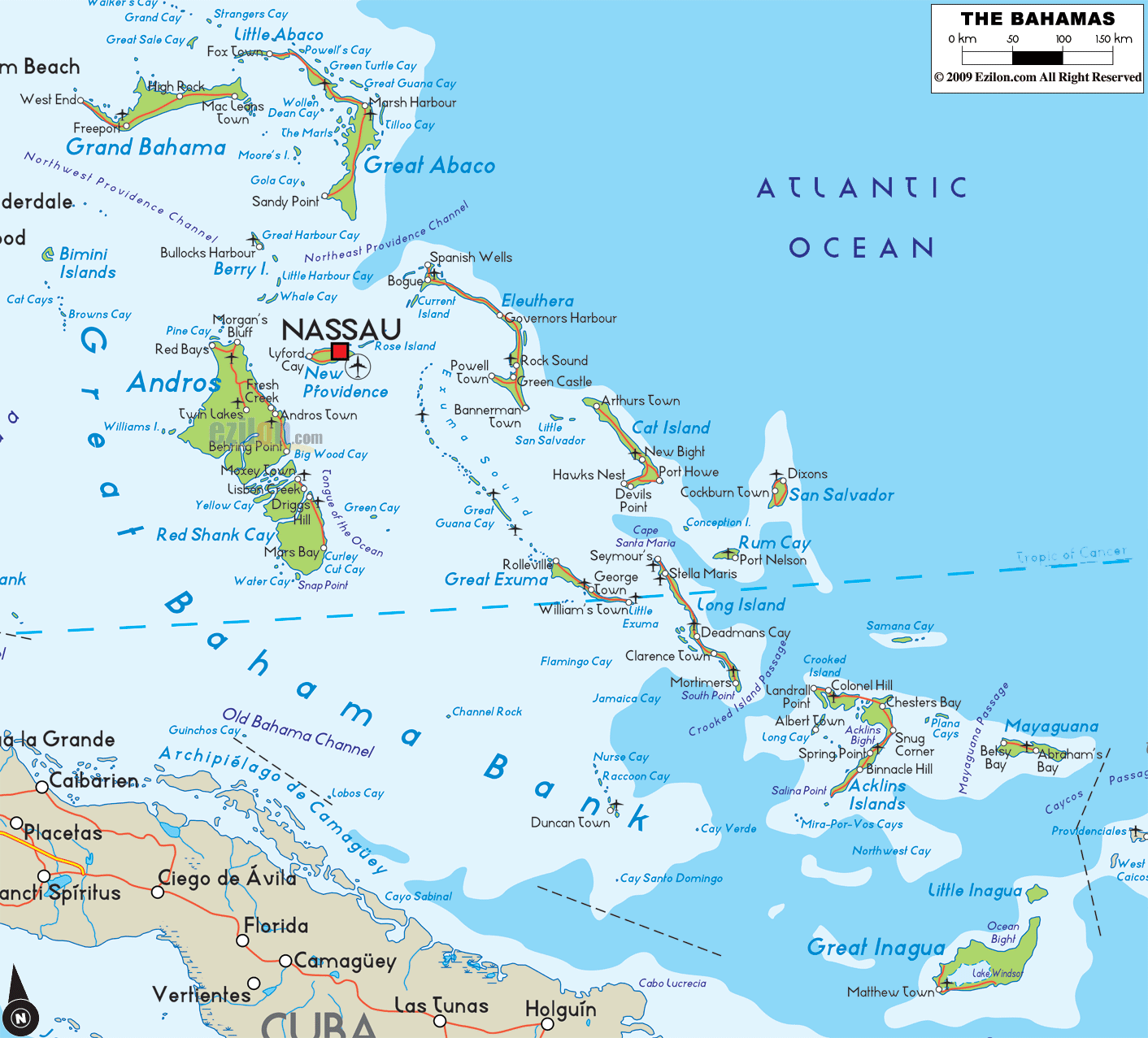
This map of The Bahamas is built for place finding. It shows named islands and cays, the capital, major towns and settlements, bays, banks, passages and a clean road-light network so you can trace the archipelago without clutter. The country stretches across the Atlantic Ocean and the Caribbean Sea above the Great Bahama Bank. Labels highlight the capital Nassau on New Providence, the large landmass of Andros, the gateway islands Grand Bahama and Great Abaco to the north, and the long southeastern chain including Cat Island, San Salvador, Rum Cay, Long Island, Acklins Islands, Mayaguana, Great Inagua and Little Inagua.
The Bahamas is an Atlantic archipelago of hundreds of islands and cays. The capital Nassau is on New Providence island. On a clear political map, Nassau appears as the largest label near the center of the island group.
The Bahamas stretches from Bimini near Florida in the northwest to Inagua near Cuba and Haiti in the southeast. The islands sit between the Atlantic Ocean and the Straits of Florida and extend toward the Windward Passage. Waters shown on a detailed map include the Great Bahama Bank, Little Bahama Bank, and deep blue trenches like the Tongue of the Ocean.
The country is divided into districts which act as local government areas. District names you will see often on a Bahamas map include New Providence, Grand Bahama, Abaco, Bimini, Berry Islands, Andros, Eleuthera, Harbour Island, Spanish Wells, Cat Island, Exuma and the Exuma Cays, Long Island, San Salvador, Rum Cay, Ragged Island, Acklins, Crooked Island, Mayaguana, and Inagua. Major settlements appear as bold labels, while resort cays and small towns show as lighter labels.
Nassau (New Providence): national capital with downtown, Paradise Island bridges, and the cruise harbor.
Freeport (Grand Bahama): main city of the northwestern islands with industrial harbor and beaches.
Marsh Harbour (Abaco): central Abaco hub on the Sea of Abaco facing the cays.
Alice Town (Bimini): gateway closest to Florida on North Bimini.
Bullocks Harbour (Berry Islands): settlement on Great Harbour Cay.
Andros Town and Nicholls Town (Andros): settlements on the largest island by area.
Governor’s Harbour, Rock Sound, and Spanish Wells (Eleuthera): long narrow island towns; Dunmore Town sits on Harbour Island.
George Town (Great Exuma): southern Exuma hub in Elizabeth Harbour.
Clarence Town (Long Island): twin-spired church town on the east coast.
Cockburn Town (San Salvador) and Port Nelson (Rum Cay): eastern islands with historic sites.
Colonel Hill (Crooked Island) and Salina Point or Snug Corner (Acklins): quiet southeastern settlements.
Abraham’s Bay (Mayaguana) and Matthew Town (Great Inagua): far southeastern anchors near the Turks and Caicos route.
Arthur’s Town (Cat Island): northern Cat Island settlement near the island’s interior ridge.
Banks and reefs: Pale turquoise on the Great Bahama Bank and Little Bahama Bank marks shallow water, while deep blue edges drop to ocean trenches.
Beaches and sounds: Calm lee sides face the banks, while ocean sides have surf and reef lines.
Blue holes and mangroves: Andros is famous for blue holes and mangrove creeks.
Cays and harbors: Exuma Cays show a long chain of sandbars and protected harbors such as Elizabeth Harbour.
A road-light Bahamas map highlights simple island spines and causeways rather than full highway numbers. Use these patterns to navigate:
New Providence loop: Ring routes around Nassau connect downtown to Cable Beach, Paradise Island bridges, and the airport area on the west side.
Grand Bahama spine: The east to west corridor links Freeport, Lucaya, and communities toward the east end.
Abaco chain: Marsh Harbour sits opposite offshore cays; ferries link to Hope Town, Man-O-War Cay, and Green Turtle Cay.
Eleuthera line: A long north to south road connects Spanish Wells and Harbour Island ferry points to Governor’s Harbour and Rock Sound.
Exuma run: George Town anchors the south with short roads to beaches and lookouts; boat routes define travel between the Exuma Cays.
Southeast islands: Short island roads connect airstrips to main settlements on Long Island, Crooked Island, Acklins, Mayaguana, and Inagua.
Lynden Pindling International Airport serves Nassau on New Providence.
Grand Bahama International Airport serves Freeport.
Marsh Harbour Airport (Abaco), North Eleuthera Airport, Governor’s Harbour Airport, Exuma International near George Town, and airstrips on Long Island, San Salvador, Cat Island, Crooked Island, Acklins, Mayaguana, and Inagua connect the family islands.
Cruise and cargo ports appear at Nassau and Freeport; mail boats and local ferries link many islands and cays.
Language: English is official and widely spoken.
Currency: Bahamian dollar (BSD), maintained at parity with the US dollar; USD is commonly accepted.
Time zone: UTC minus 5 hours, typically with daylight saving in season.
Driving: left side of the road. Roundabouts appear on New Providence and Grand Bahama.
Power: 120 V, 60 Hz, plug types A and B.
Calling code: +1 242.
Emergency: 911 or 919 in most areas.
Tropical marine climate. Drier months often run from late fall through spring. Hurricane risk peaks from August through October. Use local guidance for boating channels, reef cuts, and open crossings. On outer islands, carry water and check fuel before long drives.
Fix on Nassau and Paradise Island to anchor the center of the archipelago.
Mark Freeport to place Grand Bahama in the northwest.
Use Marsh Harbour to locate Abaco and the arc of offshore cays.
Follow Eleuthera’s long thin shape from Spanish Wells to Rock Sound.
Find George Town to unlock the Exuma Cays, then track southeast to Clarence Town, Abraham’s Bay, and Matthew Town.
At the far west of the map the Bimini Islands sit nearest to Florida. They are a good bearing point when arriving by boat from Miami and Fort Lauderdale. Their position helps you understand how the Bahamian chain bends from west to east and then sweeps southeast.
Northeast of Bimini the label Grand Bahama carries two clear town names. Freeport sits on the south shore of the island’s northwest quadrant and is the main urban center of Grand Bahama. West End lies on the island’s tip and serves as a traditional entry port. Use these names as anchors when you plan a run across the Florida Straits into Bahamian waters.
East of Grand Bahama the green shape of Great Abaco appears with Marsh Harbour as its key town. The map positions Marsh Harbour on a sheltered bay on the island’s east side. This town is the best labeled waypoint for crossing to the Abacos from Grand Bahama and then turning south into the central Bahamas.
South of the Abacos, Andros is the archipelago’s largest island and it dominates the central panel of the map. On the east side you see Andros Town which is the main settlement label for central Andros. On the northwest corner the map prints Morgan’s Bluff, a harbor that faces the deep water of the Straits. South Andros continues below the Great Bahama Bank label with a dotted coastline and small passages.
Just east of Andros the map marks NASSAU with a red square on New Providence. This is the national capital and the busiest waypoint in the country. The label placement shows its position midway between the northern islands and the southeastern chain which is why Nassau works so well as a hub for ferries and short flights.
A long narrow isle stretches southeast of New Providence. This is Eleuthera and the map highlights Governors Harbour near the center and Rock Sound farther south. The form of the island on the map helps you remember that roads follow a thin ridge from settlement to settlement with frequent sea views on both sides.
East southeast of Eleuthera sits Cat Island. The map prints Arthurs Town on the north end, New Bight near the midsection and Port Howe on the south tip. Think of these three names as a simple top to middle to bottom sequence that makes any Cat Island briefing easy to follow.
To the east a single island label stands alone. This is San Salvador and it marks the archipelago’s outer rim toward the Atlantic. The label helps pilots and sailors fix a far eastern bearing before they turn back toward Rum Cay or Long Island.
Between San Salvador and Long Island the map places Rum Cay. It is a useful waymark when crossing from the eastern rim back toward the central southeast chain.
A long ribbon south of Rum Cay is Long Island. The map shows Clarence Town on the southeast coast and Deadmans Cay near the middle of the island. When you plan a surface trip, use Deadmans Cay as the interior staging point and Clarence Town as the oceanfront harbor on the south.
West of Long Island you will see Great Exuma. The map places its name across the lower middle of the panel to show the reach of the Exuma group. From the central Bahamas many boaters use Great Exuma as a turning point toward Long Island or back toward New Providence.
Moving east and a bit south the label Acklins Islands appears, followed by Mayaguana even farther toward the Atlantic. These labels help you visualize the outer arc of the chain that guides vessels toward Turks and Caicos or back up the Bahamas line toward Long Island and Exuma.
At the bottom right the map names Great Inagua with a blue patch for Lake Windsor, and just above it Little Inagua. These are the southern foot of the country. Great Inagua’s position gives you a clean marker for the entrance to the Windward Passage and the line toward Hispaniola and Jamaica. The lake label helps with orientation from the air because it sits near the island’s center.
Keep three loops in your notes for instant place recall.
Northwest loop: Bimini Islands, Grand Bahama with Freeport and West End, Great Abaco with Marsh Harbour.
Central loop: Andros with Andros Town and Morgan’s Bluff, New Providence with Nassau, Eleuthera with Governors Harbour and Rock Sound.
Southeast loop: Cat Island with Arthurs Town, New Bight and Port Howe, San Salvador, Rum Cay, Long Island with Clarence Town and Deadmans Cay, then Great Exuma, Acklins Islands, Mayaguana, Great Inagua and Little Inagua.

Physical Map of Bahamas
Physical map and map image of Bahamas.

Regional Directory of Caribbean
Information and guide about Caribbean and website listing.

Regional Directory of United States of America
Information and guide about United States of America and websites with American topics.

Regional Directory of Europe
Information and guide about Europe and websites with European topics.

Regional Directory of Australia
Information and guide about Australia and websites with Australian topics.