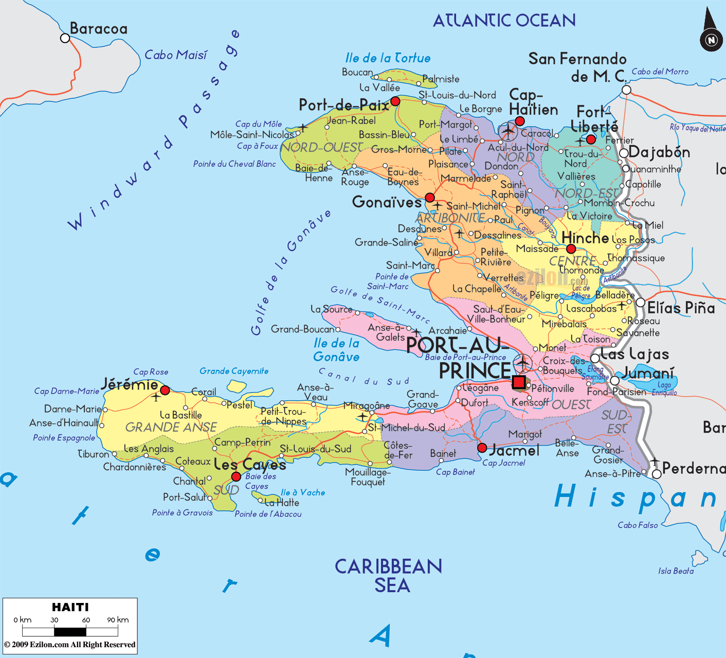
Description: Detailed large political map of Haiti showing names of capital city, towns, states, provinces and boundaries with neighbouring countries.
 Map of Haiti, featuring Haiti's cities, major cities, departments, and road network. This guide helps you scan the map. You will see the capital Port-au-Prince, the big northern city Cap-Haïtien, coastal hubs like Les Cayes and Jérémie, the inland town Hinche, and many more communities grouped inside Haiti's ten departments. The thin red lines are road-light corridors that show how people move along the coasts and across the mountains. The blue labels show the Atlantic Ocean to the north, the Caribbean Sea to the south, the Windward Passage in the northwest, and the large Golfe de la Gonâve in the middle.
Start at the far west. The map marks the Windward Passage between Haiti and Cuba. Along this windy channel, the northwestern tip of the country curves toward Pointe du Cheval Blanc and Cap à Foux. Turning south, you reach the green headland that guards Baie de Henne and points toward the remote Île de la Tortue offshore.
Across the Canal de la Gonâve, the southwest arm of Haiti begins. The department is Grand'Anse. The main town is Jérémie on the north shore of the peninsula. Around it, the map prints Dame-Marie, Anse d'Hainault, Les Irois, Abricots, Moron, and Camp-Perrin closer to the interior. These names tell you this corner is a chain of small coastal towns linked by a curving coastal road. The land is hilly, so the road clings to the shoreline.
Moving east along the same peninsula, you leave Grand'Anse and enter Sud. The largest city here is Les Cayes, set on a wide bay. Nearby, you can spot Torbeck, Cavaillon, Saint-Louis-du-Sud, Aquin, Port-Salut, Coteaux, Les Anglais, and the offshore label Île à Vache. All these places sit along a south coast road-light corridor that rings the peninsula and returns to the north side through Chardonnières and Tiburon. On the north edge of the peninsula the names Cavaillon and Saint-Jean-du-Sud mark old river mouths and small ports.
East of Sud, the coastline folds into lagoons and low hills. This is Nippes. The map shows Miragoâne on a deep bay, Anse-à-Veau, Petit-Trou-de-Nippes, L'Asile, and Baradères. The road runs close to the water, so it is easy to follow the labels as they track one bay after another.
At the center of the map, the red square marks Port-au-Prince, Haiti's capital, on the Golfe de la Gonâve. Around it, the map names Delmas, Carrefour, Pétion-Ville, Tabarre, Kenscoff, Cité-Soleil, and Croix-des-Bouquets. These places are close together and tied by short road spurs. West along the coast, you pass Gressier and Léogâne. North along the gulf, the road points to Arcahaie and Cabaret. The long island in the gulf is Île de la Gonâve, with Anse-à-Galets and Pointe-à-Raquette shown on its north and south shores.
One corridor circles the gulf from Léogâne to Saint-Marc. Another runs inland from Croix-des-Bouquets toward Mirebalais and Hinche. These corridors explain how traffic flows between the coastal plain and the central plateau.
Northwest of the capital, the Artibonite valley is easy to read because many town labels line up along the river. Look for Gonaïves near the coast, Saint-Marc on the gulf road, Dessalines, L'Estère, Grande-Saline, Verrettes, Petite-Rivière-de-l'Artibonite, Gros-Morne, Marmelade, and Saint-Michel. Roads fan from the valley to the coast and to mountain towns, so this department looks like a spider web on the map.
Turn to the north coast. The largest city here is Cap-Haïtien, shining as the second urban anchor after the capital. West of it the map shows Limonade, Quartier-Morin, Plaine-du-Nord, Acul-du-Nord, Limbé, Plaisance, and Grande-Rivière-du-Nord. East of Cap-Haïtien, the road runs past Caracol and into the edge of Nord-Est.
On the top left the Nord-Ouest coastline bends around the Golfe de la Gonâve. The department capital Port-de-Paix sits by the channel to Île de la Tortue. Nearby, the map lists Jean-Rabel, Saint-Louis-du-Nord, Bassin-Bleu, Anse-Rouge, and Baie de Henne. Farther out toward the passage are Môle-Saint-Nicolas and Cap à Foux, both strong capes that help you fix the outline of Haiti.
On the top right, Nord-Est touches the Atlantic Ocean and the Dominican border. The key names are Fort Liberté, Trou-du-Nord, and the inland market town Ouanaminthe, which faces Dajabón across the international bridge. Small places like Perches and Caracol fill the inland ridge and the coast near the lagoon.
Between the north and the capital lies the high Centre. The map highlights Hinche as the main town. Around it are Mirebalais, Lascahobas, Thomonde, Boucan-Carré, and Cerca-la-Source near the Dominican boundary. The road from Croix-des-Bouquets to Hinche and Mirebalais is a clear cross-country corridor.
Return to the south coast east of the capital. You enter Sud-Est, where the mountains drop to blue coves. The big name is Jacmel. East of it, the labels Marigot, Bainet, Belle-Anse, Thiotte, and Anse-à-Pitres lead you to the border at Pedernales. A short road runs inland to La Vallée above Jacmel.
Haiti shares a land boundary with the Dominican Republic. On the map, you can match crossings: Ouanaminthe links to Dajabón, Belladère links to Elías Piña, Malpasse near Fond Parisien links to Jimaní, and Anse-à-Pitres links to Pedernales on the far southeast. To the northwest, the Windward Passage leads to Cuba. Offshore to the north are the Bahamas across open Atlantic water.
Île de la Gonâve sits in the middle of the gulf. The towns Anse-à-Galets and Pointe-à-Raquette appear on its shores.
Île de la Tortue lies off Port-de-Paix. Small labels like La Vallée and Boucau point to settlements on the island.
Other offshore notes include Île-à-Vache near Les Cayes, and tiny islets near Les Cayes and Jérémie that shape the local reefs.
Bays help you place cities. Baie de Henne in Nord-Ouest, Baie des Moustiques and Baie de l'Acul near Cap-Haïtien, Baie de Jacmel, Baie des Cayes, and the wide Golfe de la Gonâve around the capital are the biggest blue names.
North coast arc. One corridor runs from Port-de-Paix through Saint-Louis-du-Nord, Limbé, Cap-Haïtien, Fort Liberté, and down toward the Dominican line.
Valley spine. A second corridor runs south from Gonaïves and Saint-Marc into Mirebalais and Hinche. It connects farmland to the ports.
Capital ring. Short spurs tie Port-au-Prince with Carrefour, Pétion-Ville, Delmas, Croix-des-Bouquets, Léogâne, and Arcahaie.
Southern loop. A coastal road loops Les Cayes, Aquin, Jacmel, Marigot, Bainet, and back toward the plain west of the capital. Another branch swings west to Jérémie, completing the long loop around the southwestern peninsula.
When you trace these lines on the map, you can see how travel usually follows the coast or valleys. Mountain areas hold fewer labels and fewer roads, so most towns sit where rivers reach the sea.
Port-de-Paix, Jean-Rabel, Saint-Louis-du-Nord, Bassin-Bleu, Anse-Rouge, Baie de Henne, Môle-Saint-Nicolas.
Cap-Haïtien, Limonade, Quartier-Morin, Plaine-du-Nord, Acul-du-Nord, Limbé, Plaisance, Grande-Rivière-du-Nord.
Fort Liberté, Trou-du-Nord, Ouanaminthe.
Gonaïves, Saint-Marc, Dessalines, L’Estère, Grande-Saline, Verrettes, Petite-Rivière-de-l’Artibonite, Gros-Morne, Marmelade, Saint-Michel.
Hinche, Mirebalais, Lascahobas, Thomonde, Boucan-Carré, Cerca-la-Source.
Port-au-Prince, Delmas, Pétion-Ville, Carrefour, Croix-des-Bouquets, Kenscoff, Léogâne, Gressier, Arcahaie, Cabaret, Cité-Soleil, plus Anse-à-Galets and Pointe-à-Raquette on Île de la Gonâve.
Miragoâne, Anse-à-Veau, Petit-Trou-de-Nippes, L’Asile, Baradères.
Les Cayes, Aquin, Saint-Louis-du-Sud, Cavaillon, Port-Salut, Coteaux, Les Anglais, Île-à-Vache.
Jérémie, Dame-Marie, Anse d’Hainault, Les Irois, Abricots, Moron, Camp-Perrin.
Jacmel, Marigot, Bainet, Belle-Anse, Thiotte, Anse-à-Pitres.
Find the red square for Port-au-Prince to center yourself.
Follow the coast clockwise to meet each department in turn.
Use blue bay names to match cities to water bodies.
Use red road ribbons to judge how to drive between towns.
Crossings into the Dominican Republic line up with Ouanaminthe, Belladère, Malpasse, and Anse-à-Pitres.

Physical Map of Haiti
Physical map and map image of Haiti.

Regional Directory of Caribbean
Information and guide about Caribbean and website listing.

Regional Directory of United States of America
Information and guide about United States of America and websites with American topics.

Regional Directory of Europe
Information and guide about Europe and websites with European topics.

Regional Directory of Australia
Information and guide about Australia and websites with Australian topics.