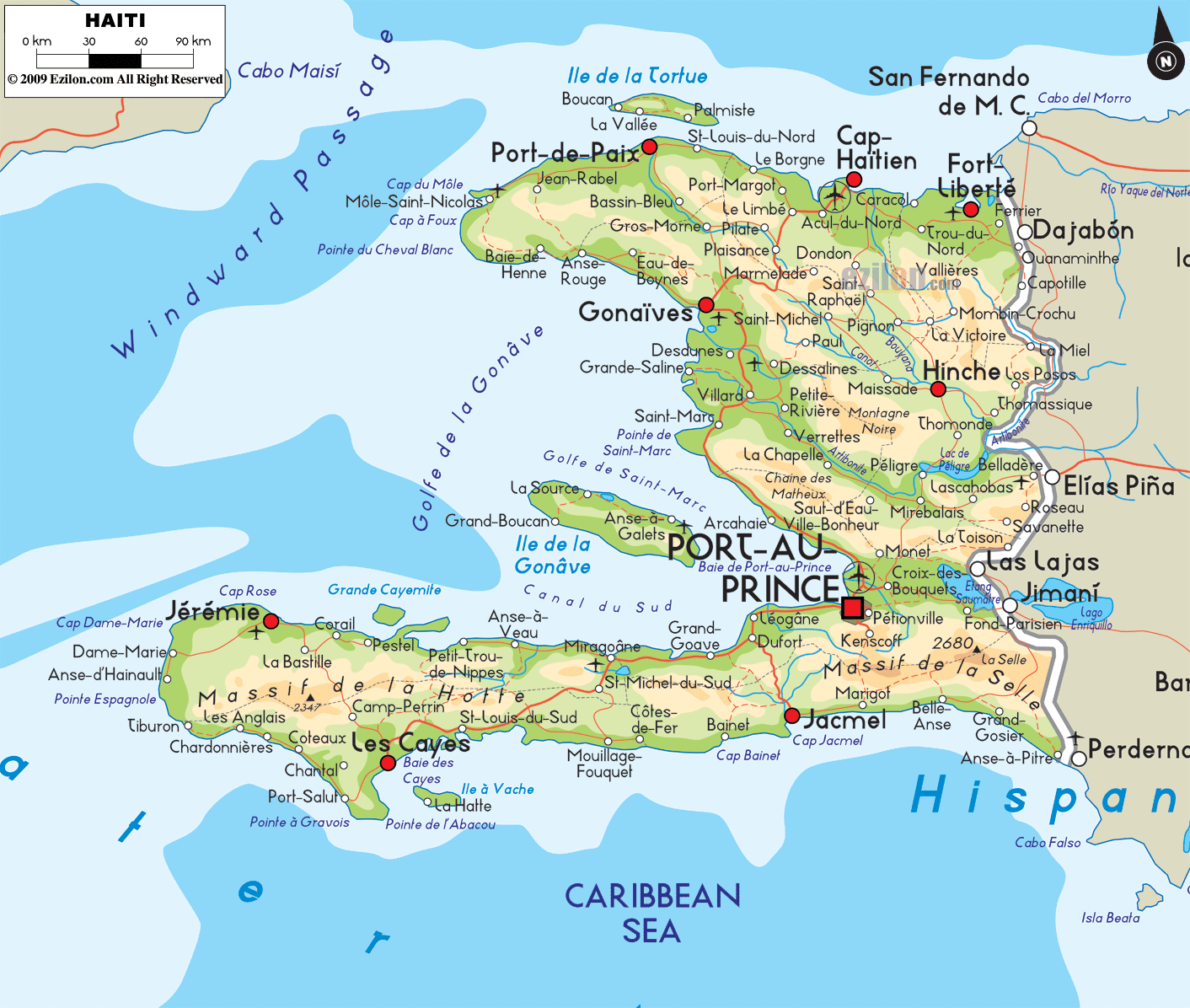
Description: The Physical Map of Haiti showing major geographical features like elevations, mountain ranges, ocean, lakes, plateaus, peninsulas, rivers, plains, landforms and other topographic features.
This map of Haiti with mountains, hills, lakes, rivers and other terrains is already large enough to read directly on your desktop. To see a full-screen zoom view on a phone or tablet, tap the map image (or tap the Zoom Map label above the image). Scan by shading departments in various colored blocks, with Haiti's mountains, hills, lakes and rivers in bold.
 Haiti
is an island country located in the Caribbean group of
islands. It is placed between the Caribbean Sea and
Atlantic Ocean. The country lies between north latitude
19 degrees and west longitude 72.25 degrees. The total
area covered by the country is 27,750 square kilometers
out of which 27,560 square kilometers is land and 190
square kilometers is water.
Haiti
is an island country located in the Caribbean group of
islands. It is placed between the Caribbean Sea and
Atlantic Ocean. The country lies between north latitude
19 degrees and west longitude 72.25 degrees. The total
area covered by the country is 27,750 square kilometers
out of which 27,560 square kilometers is land and 190
square kilometers is water.
The coastlines of the country on both sides add up to be
1,771 kilometers long. The highest point in the country
is called Pic La Selle as it sits at a height of 2,680
meters above sea level whereas the lowest natural point
rests at mean sea level on the Caribbean Sea.
The longest river in the nation is known as the
Artibonite River as it flows for 320 kilometers. The
river originates in the Cordillera Central Mountain
Range.
The climate of the country is mostly tropical which is
frequented by the trade winds. Most of the country is
mountainous as 3 quarters of the nation sits above 700
feet. The country also has a few lakes in the
surrounding islands which are a part of the nation's
land. The largest lake is known as the Azuei Lake as it
has a surface area of 70 square kilometers.

Political Map of Haiti
Political map and map image of Haiti.

Regional Directory of Caribbean
Information and guide about Caribbean and website listing.

Regional Directory of United States of America
Information and guide about United States of America and websites with American topics.

Regional Directory of Europe
Information and guide about Europe and websites with European topics.

Regional Directory of Australia
Information and guide about Australia and websites with Australian topics.