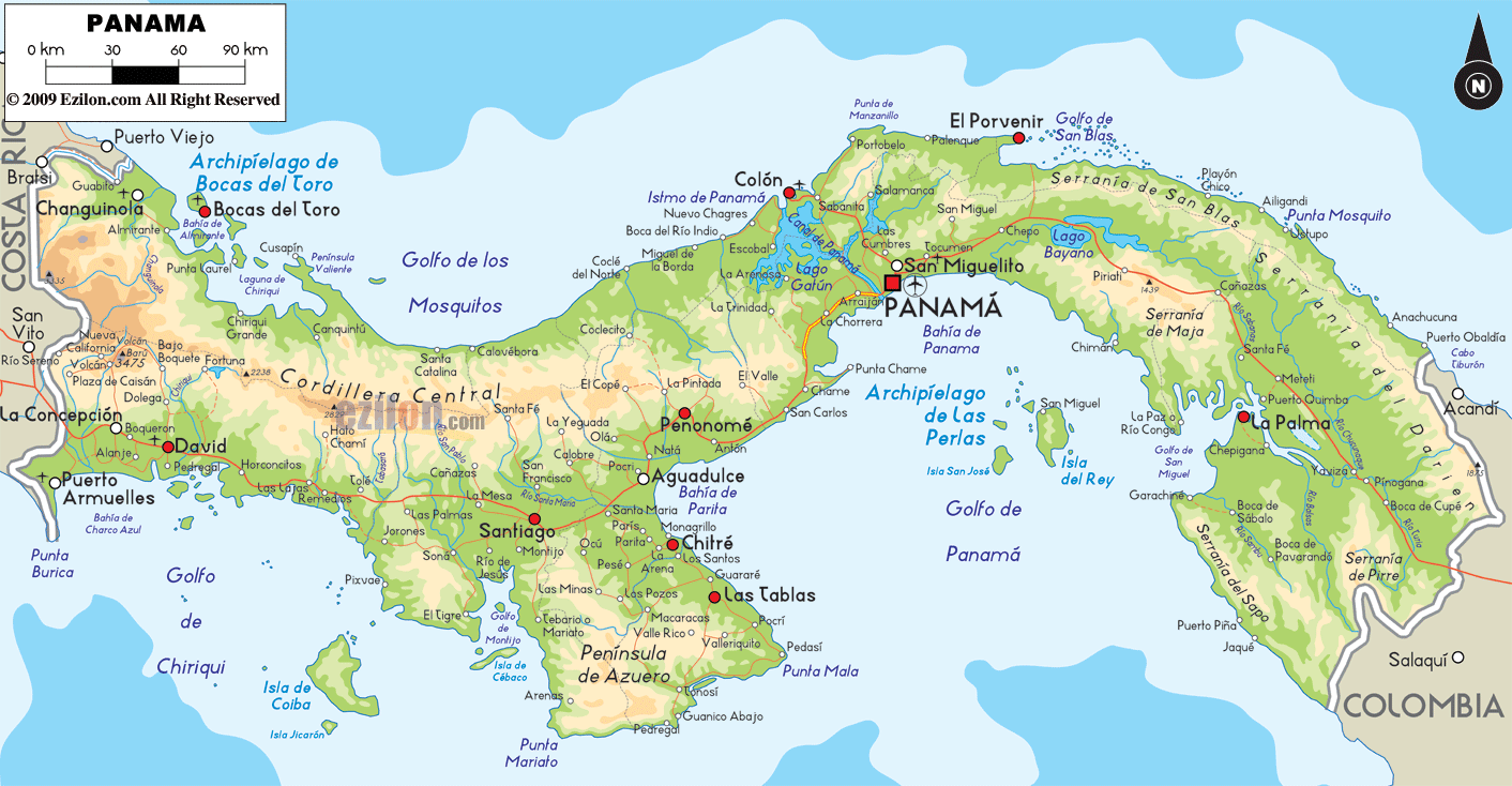
Description: The Physical Map of Panama showing major geographical features like elevations, mountain ranges, deserts, lakes, plateaus, peninsulas, rivers, plains, landforms and other topographic features.
 Panama
is a country situated in Central America. The country
shares coastlines with both the North Pacific Ocean and
Caribbean Sea. The country lies on the Isthumus of
Panama and is an S shaped country. The country lies
between north latitudes 7 and 10 degrees and west
longitudes 77 and 83 degrees. The country takes up
77,082 square kilometers.
Panama
is a country situated in Central America. The country
shares coastlines with both the North Pacific Ocean and
Caribbean Sea. The country lies on the Isthumus of
Panama and is an S shaped country. The country lies
between north latitudes 7 and 10 degrees and west
longitudes 77 and 83 degrees. The country takes up
77,082 square kilometers.
The country has a spinal cord of mountains running
along the length. The mountains are not a part of the
ones running in North and South America.
The major mountain range is called the Cordillera de
Talmanca which becomes the Serrania de Tabasara in the
east. Volcan Baru is the highest point in the country
which rises to a maximum height 3,475 meters.
There are nearly 500 rivers which run across the
landscape of the Panama country. Most of them are
shallow and short except the Rio Chagres and Rio Chepo.
Two major lakes in the country are Kampia Lake and
Madden Lake. Rio Tuira is the longest river in the
country. The lowest point in the country rests at mean
sea level on the Pacific Ocean. The country is
characterized by steep central area bordered by the
coastal plains on both sides.

Political Map of Panama
Political map and map image of Panama.

Regional Directory of Caribbean
Information and guide about Caribbean and website listing.

Regional Directory of United States of America
Information and guide about United States of America and websites with American topics.

Regional Directory of Europe
Information and guide about Europe and websites with European topics.

Regional Directory of Australia
Information and guide about Australia and websites with Australian topics.