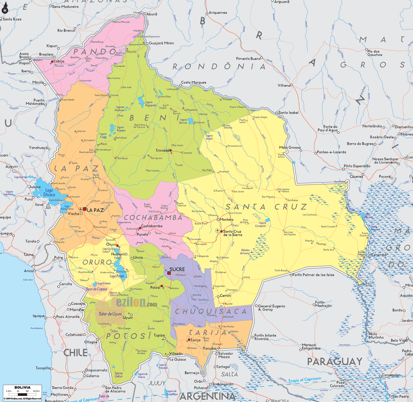
Description: Detailed large political map of Bolivia showing names of capital city, towns, states, provinces and boundaries with neighbouring countries.
 Detailed map of Bolivia with cities, towns, departments, villages and surrounding countries. Bolivia shares borders with Peru, Chile, Argentina, Paraguay and Brazil. Map of Bolivia with cities, provinces, and road network. Detailed map. Best map. This straightforward guide walks from north to south and west to east, allowing any reader to scan the map and quickly locate the places marked in bold.
Bolivia is divided into nine departments. A red square marks a capital city. Red dots show important towns. Thin red lines show the main road-light corridors. Lakes, rivers, and border names help you keep your bearings.
Official name: Plurinational State of Bolivia
Capitals: La Paz (seat of government), Sucre (constitutional capital)
Departments: La Paz, Oruro, Potosí, Cochabamba, Chuquisaca, Tarija, Santa Cruz, Beni, Pando
Largest cities: Santa Cruz de la Sierra, El Alto, La Paz, Cochabamba, Sucre
Highest landmarks on the map: the Altiplano around La Paz, Lake Titicaca, and the Salar de Uyuni
Gateways: El Alto International near La Paz and Viru Viru International near Santa Cruz
Neighbors: Peru, Chile, Argentina, Paraguay, Brazil
Bolivia names two capitals on the map.
La Paz is the seat of government. Please find it in the west, inside the La Paz department, above El Alto, and near Lake Titicaca.
Sucre is the constitutional capital. Look for the red square in the Chuquisaca department in the south-central highlands.
From north to south, the high plateau holds several departments and well-known cities.
In the far west, the map shows La Paz, El Alto, and Viacha. On the lake shore northward are Copacabana and Achacachi along Lake Titicaca. To the northeast, the road drops toward the Yungas with towns such as Coroico and Caranavi.
Directly south of La Paz is Oruro, with its capital, Oruro. Nearby, you will spot Poopó and Challapata close to Lake Poopó and the salt flats.
Continue south, and the label changes to Potosí. The city of Potosí stands east of the Salar de Uyuni, which is marked on the map as a vast white basin with towns like Uyuni, Colchani, and Llica around its edge. The corridor from Oruro through Challapata to Uyuni is easy to follow.
At the far south, look for Tarija on the valley floor. Further east and south, the map marks Villamontes, Yacuiba, and Bermejo on the border with Argentina and Paraguay.
In the center, the bright label Cochabamba shows a crowded valley. The capital Cochabamba sits between Quillacollo to the west and Sacaba to the east. Other valley towns include Punata, Cliza, Tarata, and Totora along the eastbound route to Santa Cruz.
South of Cochabamba is Chuquisaca. Its red square marks Sucre. Smaller towns such as Zudáñez, Tarabuco, Camargo, Monteagudo, and Muyupampa appear across the folded hills.
The largest yellow area is Santa Cruz. The government department capital, Santa Cruz de la Sierra, is near the center right. North and west of the city, the road passes Warnes and Montero. Eastward, the Chiquitania corridor marks Cotoca, Pailón, San José de Chiquitos, Roboré, and Puerto Suárez near Brazil. North of the Pantanal, you will also find San Matías on the border. Southward towns such as Abapó and Camiri lead toward Yacuiba.
Above Santa Cruz, the green area is Beni. The capital, Trinidad, sits near rivers and wetlands. Farther north, the map names Rurrenabaque, Reyes, San Borja, Santa Ana de Yacuma, Riberalta, and Guayaramerín along rivers that flow toward Brazil.
In the far northwest, Pando hugs the Brazilian frontier. The capital, Cobija, lies across the river from Brasiléia. The road network is light, and river names guide you to crossings such as Riberalta to the east.
Peru borders the La Paz area around Lake Titicaca and along the high Andes.
Chile touches the Oruro and Potosí corner to the southwest.
Argentina borders Potosí and Tarija along valleys and the Pilcomayo region.
Paraguay lies southeast of Santa Cruz and Tarija across the Chaco.
Brazil wraps around the north and east, meeting Pando, Beni, and Santa Cruz along the Acre, Beni, Mamore, Guaporé, or Iténez, and Paraguay river systems.
Key inland waters you can point to on the map are Lake Titicaca, Lake Poopó, the Salar de Uyuni, the Mamore and Beni rivers, and the wetlands of the Llanos de Moxos.
Highland spine La Paz to Oruro to Potosí to Tarija. This is the classic Andean path that links the main cities of the Altiplano and the south.
Trans-Bolivia east-west route, Cochabamba to Santa Cruz de la Sierra to San José de Chiquitos to Puerto Suárez on the Brazilian line. This line crosses valleys, forests, and the southern edge of the Pantanal.
Northern wetlands route Cochabamba to Trinidad, then north to Riberalta and Guayaramerín along the Mamore and Beni river basins.
Yungas descend from La Paz across El Alto and down to Coroico and Caranavi, where the mountain road meets the forest lowlands.

Physical Map of Bolivia
Physical map and map image of Bolivia.

Regional Directory of South America
Information and guide about South America and website listing.

Regional Directory of United States of America
Information and guide about United States of America and websites with American topics.

Regional Directory of Europe
Information and guide about Europe and websites with European topics.

Regional Directory of Australia
Information and guide about Australia and websites with Australian topics.