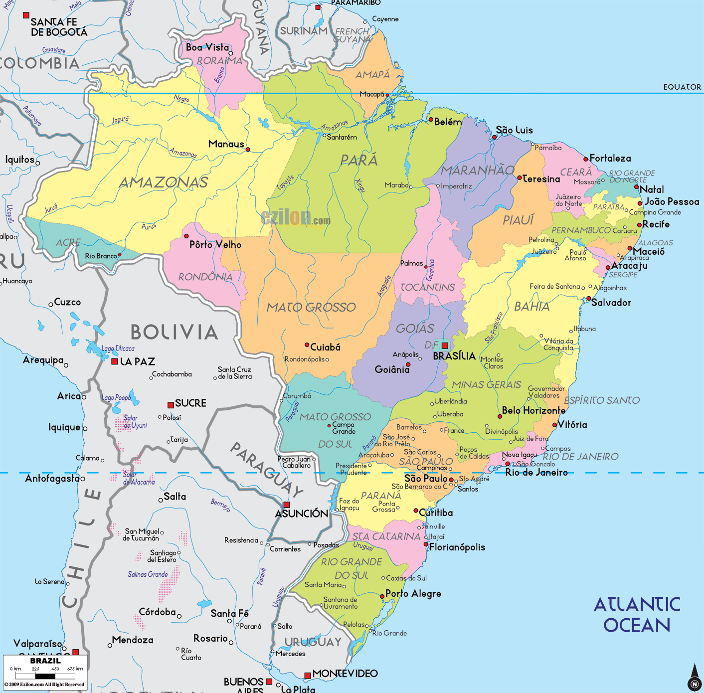
Description: Detailed large political map of Brazil showing names of capital city, towns, states, provinces and boundaries with neighbouring countries.
 Map of Brazil with cities, states, provinces, and road networks. Detailed map. Best map. This guide follows the labels you see on the map and speaks in plain language so anyone can quickly find places.
Brazil consists of 26 individual states plus the Federal District.
A red square shows a state capital or the national capital.
Red dots are important cities and towns.
Thin red lines are the main road-light corridors that link regions.
Blue labels show coasts, rivers, and neighboring borders so you can keep your bearings.
Brazil is officially called the 'Federative Republic of Brazil'.
The capital is Brasília in Federal District.
Largest metro: São Paulo.
More than 200 million people in five regions.
Language: Portuguese.
Currency: Real (BRL).
States: Acre, Alagoas, Amapá, Amazonas, Bahia, Ceará, Espírito Santo, Goiás, Maranhão, Mato Grosso, Mato Grosso do Sul, Minas Gerais, Pará, Paraíba, Paraná, Pernambuco, Piauí, Rio de Janeiro, Rio Grande do Norte, Rio Grande do Sul, Rondônia, Roraima, Santa Catarina, São Paulo, Sergipe, plus Distrito Federal
Time: mostly Brasília Time with western offsets in Acre and parts of Amazonas
Air gateways: São Paulo Guarulhos, Rio de Janeiro Galeão, Brasília, Belo Horizonte Confins, Salvador, Recife, Fortaleza, Manaus, Belém, Porto Alegre
Landmarks on this map: Amazon River, Rio Negro, Madeira River, São Francisco River, Pantanal wetlands, Atlantic coast with long beaches
Neighbors: every South American country except Chile and Ecuador
Roraima sits at the far north. The capital, Boa Vista, appears along the Rio Branco near the border with Guyana and Venezuela. The road corridor points south toward Amazonas.
Amapá is a state on the equator facing the Atlantic. You will see Macapá on the north bank of the Amazon River estuary, across from Belém in Pará.
Amazonas is the largest state on the map, stretching from the Colombia and Peru borders to the center of Brazil. The capital Manaus stands on the Rio Negro just above its meeting with the Amazon River. The map shows road links west to Porto Velho and east toward Boa Vista and Roraima.
Pará fills the lower Amazon basin. Belém appears at the mouth of the Amazon with ferry and road links. Inland names like Marabá hint at the east-west corridor that crosses the state. To the south, the Xingu and Tapajós rivers flow north across Pará into the main Amazon channel.
Acre lies on the far west border with Peru and Bolivia. Look for Rio Branco as the state capital. The road-light line connects eastward into Rondônia.
Rondônia shows Porto Velho on the upper Madeira River, with the corridor running southeast toward Mato Grosso.
Maranhão begins the long Atlantic bend. São Luís is on an island just off the mainland. The eastern highway goes toward Piauí.
Piauí is narrow on the coast but wider inland. The capital, Teresina, sits inland on a river junction, and the coastal access is near Parnaíba, just west of Ceará.
Ceará shows Fortaleza on a broad bay. West and east of Fortaleza, the coast road connects beach towns, while inland labels such as Crateús mark dry interior plateaus.
Rio Grande do Norte is the little point sticking into the Atlantic. Natal appears in the far east of the state.
Paraíba lies just south. João Pessoa sits near the coast, with the corridor continuing to Pernambuco.
Pernambuco shows Recife on the shore and Olinda just north of it. The corridor runs southwest toward Caruaru and onward to the interior.
Alagoas displays Maceió on a deep blue bay. The coastal road tracks south to Sergipe.
Sergipe is the smallest state on the mainland. Aracaju appears on the mouth of the Rio Sergipe, with bridges and beach strips marked on the coast.
Bahia is a vast state that wraps around the eastern bulge of Brazil. Salvador stands on a peninsula in the Baía de Todos os Santos. Inland, Feira de Santana is a road hub on the way to the interior. South along the shore, the map traces the highway to Vitória in Espírito Santo, while west the labels head toward Goiás and Minas Gerais.
The Amazon River flows from Peru to the Atlantic with major branches Rio Negro, Madeira, Xingu, and Tapajós.
The São Francisco River rises in Minas Gerais and flows northeast toward the Bahian interior.
Atlantic Ocean across the long northeastern and eastern shoreline.
Tocantins bridges the north and the center. Palmas sits near the Tocantins River, with road-light lines north to Pará and south to Goiás.
Goiás and the Federal District form the inland heart of the country. Goiânia is the capital of Goiás, located in the small, separate area called the Distrito Federal. The red square marks Brasília, the national capital, built on a high plateau. The map shows straight corridors from Brasília to Belo Horizonte, Goiânia, and Rio de Janeiro.
Mato Grosso covers forest and savanna. Cuiabá is the capital. The southern margin touches the Pantanal wetlands shared with Mato Grosso do Sul.
Mato Grosso do Sul has Campo Grande as its capital. Notice the corridors running south toward Paraguay and east toward São Paulo.
Minas Gerais occupies the mountains north of Rio de Janeiro. Belo Horizonte is the capital, with Uberaba, Uberlândia, and Juiz de Fora on the map as major inland cities. The road-light corridor from Belo Horizonte runs south to Rio de Janeiro and west to São Paulo.
Espírito Santo is a small coastal state with Vitória on an island bay. The coastal corridor heads north to Bahia and south to Rio de Janeiro.
Rio de Janeiro city hugs Guanabara Bay with corridors west to São Paulo and north to Minas Gerais.
São Paulo is Brazil’s largest state economy and home to its largest city, São Paulo. The map shows nearby hubs Campinas, Santos on the coast, Sorocaba, São José dos Campos, and the inland route to Curitiba.
Paraná has Curitiba as its capital. South along the coast lies Santa Catarina with its island capital, Florianópolis. At the far south, Rio Grande do Sul shows Porto Alegre near the Guaíba lagoon, with the border crossing to Uruguay beyond Pelotas and Bagé.
French Guiana, Suriname, and Guyana along the far north from Amapá through Roraima.
Venezuela is to the north of Roraima and Amazonas.
Colombia and Peru along the Amazon frontier.
Bolivia from Acre and Rondônia east to Mato Grosso and Mato Grosso do Sul.
Paraguay, Argentina, and Uruguay form the southern arc from Mato Grosso do Sul to Rio Grande do Sul.
The entire eastern rim faces the Atlantic Ocean.
Coastal corridor from Macapá and Belém to São Luís, Fortaleza, Natal, João Pessoa, Recife, Maceió, Aracaju, Salvador, Vitória, Rio de Janeiro, Santos, Curitiba, Florianópolis, and Porto Alegre.
Inland spine from Belém through Marabá to Palmas, Goiânia, Brasília, Belo Horizonte, São Paulo, and down to the southern capitals.
Amazon trunk connecting Manaus with Porto Velho, then east toward Cuiabá and Campo Grande. These are not numbered on the map but match the most used federal highways.

Physical Map of Brazil
Physical map and map image of Brazil.

Regional Directory of South America
Information and guide about South America and website listing.

Regional Directory of United States of America
Information and guide about United States of America and websites with American topics.

Regional Directory of Europe
Information and guide about Europe and websites with European topics.

Regional Directory of Australia
Information and guide about Australia and websites with Australian topics.