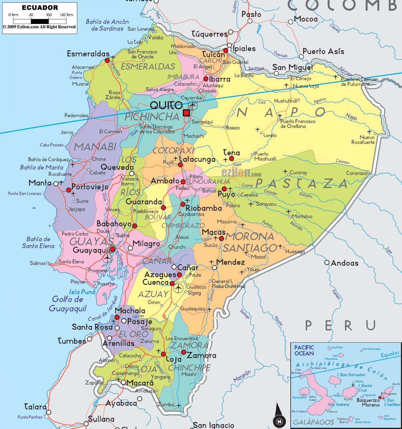
Description: Detailed large political map of Ecuador showing names of capital city, towns, states, provinces and boundaries with neighbouring countries.
 Map of Ecuador, featuring cities, major cities, provinces, and a road network. Detailed map. Best map. Use this guide while looking at the image so you can point to each province, spot the capital, and follow the main corridors that connect the Andes, the Pacific coast, and the Amazon plain.
Official name: Republic of Ecuador
Capital: Quito
Largest city: Guayaquil
Population: about 18 million
Languages: Spanish nationwide, plus Kichwa and other indigenous languages in many areas
Currency: United States dollar (USD)
Regions you see on the map: Pacific Coast, Andes Sierra, Amazon lowlands, and Galápagos Islands. Highest peaks near cities you read: Chimborazo near Riobamba, Cotopaxi near Latacunga, Tungurahua near Ambato, and Baños
Main airports shown by city: Quito, Guayaquil, Manta, Cuenca, Loja, Esmeraldas, Tena, Puyo, Macas, Machala
Popular corridors to follow on the map: Quito to Guayaquil through Latacunga, Ambato, Riobamba. Quito to the coast through Santo Domingo, Quevedo, and Manta. Quito to the Amazon through Papallacta to Tena and Baeza, or through Baños to Puyo. Cuenca to Loja and then to the Peru line.
Ecuador sits on the western side of South America. The Pacific Ocean is on the west. Colombia borders the north. Peru borders the east and south. The red square marks the national capital, Quito. Red dots mark other cities and towns. Thin red lines show the road-light network that links the regions.
At the top center near the border, you will find Carchi. Its capital, Tulcán, is close to the crossing toward Ipiales in Colombia. South of Carchi, the map shows Imbabura with Ibarra and towns like Otavalo and Cotacachi along the central valley. Continuing south, you arrive in Pichincha, where the red square shows Quito tucked between Andean ridges. On the Quito ring, you can read Sangolquí and San Antonio, then the corridor drops toward Latacunga in Cotopaxi province.
Shift left to the shore. Esmeraldas province hugs the northwest corner with the city of Esmeraldas on the bay. The coastal corridor turns south into Manabí. You can trace the line through Manta, Portoviejo, Bahía de Caráquez, and Jipijapa. These names are prominent and easy to follow on the map.
Back in the Andes, Cotopaxi is centered by Latacunga beneath the famous volcano. The map then places Tungurahua with Ambato, and Chimborazo with Riobamba. You can follow the valley corridor from Quito–Latacunga–Ambato–Riobamba like a ladder down the spine of the country.
To the east of Pichincha and Cotopaxi, a wide yellow-green block shows Napo, with capital Tena along the Napo River road. Southeast of Napo lies Pastaza, where Puyo is the urban anchor. These two provinces mark the upper edge of Ecuador’s Amazon region. Their towns line up along rivers and paved routes that climb back to the Sierra.
Further south, the map shows Cañar with its capital, Azogues, and then Azuay, where the historic city of Cuenca stands out. Below Azuay sit Loja and Zamora Chinchipe. Loja city is clearly near the valley junction, while Zamora faces the Amazon slope.
Return to the coast. Guayaquil, Ecuador’s biggest port, is the center of the large pink province of Guayas. Around it, you can see Daule, Milagro, Babahoyo across the river in Los Ríos, and the Santa Elena Peninsula with Salinas and La Libertad at the tip. South of Guayas, the map marks El Oro with the capital Machala near the Gulf of Guayaquil and the Peruvian line.
In the lower right inset, you will notice the Galápagos Islands in the Pacific. The labels include Puerto Baquerizo Moreno on San Cristóbal, Puerto Ayora on Santa Cruz, and Isabela with Puerto Villamil. The inset shows their position west of the mainland along the Equator.
The red square on Quito helps you center the whole map. From here:
North to Cayambe and Otavalo toward Ibarra.
South to Latacunga, Ambato, Riobamba, then to Alausi and the southern cities.
West through the Santo Domingo gateway toward Quevedo and Manta.
East to the Papallacta pass that drops into Tena and Puyo.
In Esmeraldas, the road hugs the shore from San Lorenzo down to Esmeraldas city. Entering Manabí, you pass Pedernales, sweep to Bahía de Caráquez, then inland to Portoviejo and back to the shore at Manta. Southbound, the corridor crosses Jipijapa and Puerto López, then turns toward Guayaquil.
Guayaquil spreads along the Guayas River delta. Bridges link Daule and Durán. The map marks Milagro northeast and Babahoyo on the Los Ríos bank. From here, you can head to Quevedo or down the coast to Playas. This network is the busiest coastal cluster on the map.
From Latacunga, you descend to Ambato in Tungurahua. The map shows nearby Baños, a gateway to the Amazon slope, then Riobamba in Chimborazo beneath the ice-capped peak. The line continues to Alausi and Chunchi, then reaches Azogues and Cuenca in Azuay.
South of Cuenca, you enter Loja province. Loja city appears near the crossroad that branches to Catamayo and Vilcabamba. Eastward, the map shows Zamora in Zamora Chinchipe, a signal that you have crossed the wet, forested side of the Andes. The trunk route then meets El Oro, where Machala, Santa Rosa, and Arenillas line the road toward the border with Peru.
On the east, Tena in Napo and Puyo in Pastaza serve as calm hubs. South of Pastaza, the map labels Morona Santiago with Macas and Sucúa on rivers that drain to the Amazon. Their roads climb back to the Sierra at Riobamba or Cuenca.
Colombia across Carchi and the eastern forest line.
Peru along El Oro, Loja, Zamora Chinchipe, Morona Santiago, and Pastaza.
The Pacific Ocean along Esmeraldas, Manabí, Santa Elena, Guayas, and El Oro.

Physical Map of Ecuador
Physical map and map image of Ecuador.

Regional Directory of South America
Information and guide about South America and website listing.

Regional Directory of United States of America
Information and guide about United States of America and websites with American topics.

Regional Directory of Europe
Information and guide about Europe and websites with European topics.

Regional Directory of Australia
Information and guide about Australia and websites with Australian topics.