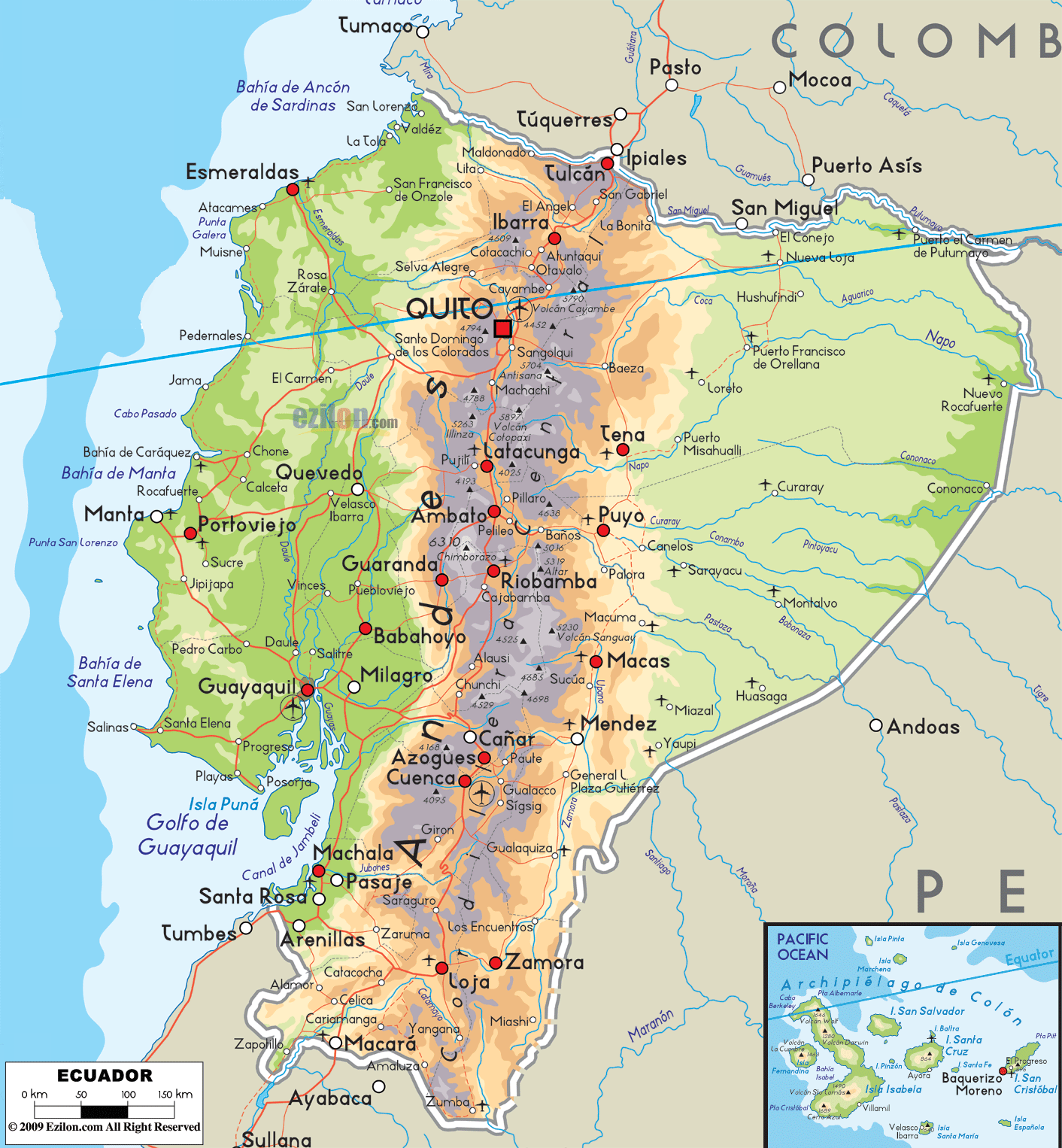
Description: The Physical Map of Ecuador showing major geographical features like elevations, mountain ranges, ocean, lakes, plateaus, peninsulas, rivers, plains, landforms and other topographic features.
This map of Ecuador with mountains, hills, lakes, rivers and other terrains is already large enough to read directly on your desktop. To see a full-screen zoom view on a phone or tablet, tap the map image (or tap the Zoom Map label above the image). Scan by shading provinces in various colored blocks, with Ecuador's mountains, hills, lakes and rivers in bold.
 Detailed Physical map of Ecuador showing the andes mountains, amazon rainforest and the galápagos islands, elevations and other topographic features. Ecuador is bordered by Colombia to the north and Peru to the east and south.
The country's official name is the Republic of Ecuador, which
literally means the "Republic of the Equator". This
country is a democratic republic located in the northwestern region
of South America, facing the Pacific Ocean to the
west. Ecuador also includes the Galápagos Islands in the
Pacific, situated about 1,000 kilometres west of the
mainland.
Detailed Physical map of Ecuador showing the andes mountains, amazon rainforest and the galápagos islands, elevations and other topographic features. Ecuador is bordered by Colombia to the north and Peru to the east and south.
The country's official name is the Republic of Ecuador, which
literally means the "Republic of the Equator". This
country is a democratic republic located in the northwestern region
of South America, facing the Pacific Ocean to the
west. Ecuador also includes the Galápagos Islands in the
Pacific, situated about 1,000 kilometres west of the
mainland.
Ecuador covers a total area of 284,000 square
kilometers. Chimborazo volcano which forms the farthest
point from the centre of the Earth is also present in
this country.
The country has four major geographic regions:
•La Costa: This coastal region is the most fertile as
well as productive land
•La Sierra: These highlands consist of the Andean as
well as the Interandean highlands. This region contains
most of the volcanoes and the entire snow-capped peaks.
•La Amazonía: Thisoriente consists of the Amazon jungle
•La Región Insular: It is the region comprising of the
Galápagos Islands, some 1,000 kilometres to the west of
the mainland and are present in the Pacific Ocean.
Cotopaxi, which lies just to the south of Quito consists
of one of the highest active volcanoes on earth. The
topmost of them all is the Mount Chimborazo which stands
at 6,268 meters above sea level.

Political Map of Ecuador
Political map and map image of Ecuador.

Regional Directory of South America
Information and guide about South America and website listing.

Regional Directory of United States of America
Information and guide about United States of America and websites with American topics.

Regional Directory of Europe
Information and guide about Europe and websites with European topics.

Regional Directory of Australia
Information and guide about Australia and websites with Australian topics.
