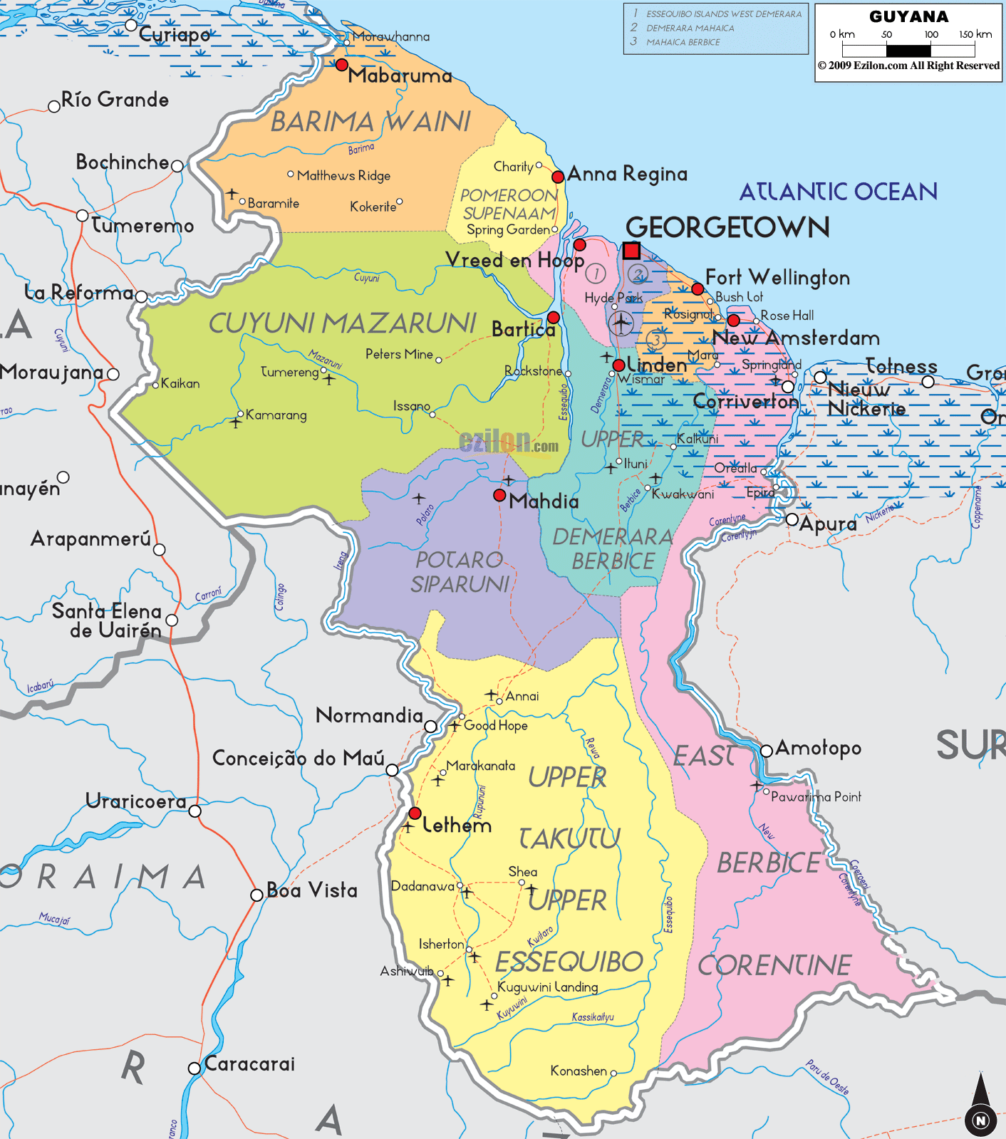
Description: Detailed large political map of Guyana showing names of capital city, towns, states, provinces and boundaries with neighbouring countries.
 Map of Guyana with major cities, provinces, and road network. Detailed map. Best map. Use this guide side by side with the image to trace every region, find each town label, and follow the simple road-light corridors that join the coast with the interior rivers.
Official name: Co-operative Republic of Guyana
Capital: Georgetown Regions on the map: Barima Waini, Pomeroon Supenaam, Essequibo Islands West Demerara, Demerara Mahaica, Mahaica Berbice, East Berbice Corentyne, Cuyuni Mazaruni, Upper Demerara Berbice, Potaro Siparuni, Upper Takutu Upper Essequibo
Largest towns shown: Georgetown, New Amsterdam, Linden, Anna Regina, Bartica, Mahdia, Mabaruma, Lethem, Corriverton. Population: about 800,000 people spread along the coast and river valleys
Languages: English is the official language, with Guyanese Creole widely spoken
Currency: Guyana dollar (GYD)
Borders: Venezuela to the west, Brazil to the south, Suriname to the east, Atlantic Ocean to the north
How to use the map: follow rivers for interior travel, use the coastal ribbon for town-to-town movement, and use named junction towns like Vreed en Hoop, Bartica, Linden, and Lethem as anchors.
Guyana is on the northern shoulder of South America. The Atlantic Ocean touches the entire north coast. Venezuela borders the west, Brazil borders the south, and Suriname borders the east across the Corentyne River. The red square marks the national capital, Georgetown, on the coast. Red dots mark towns. Colored blocks mark the ten administrative regions.
Barima Waini occupies the far northwest corner against Venezuela. Labels you can read include Mabaruma, Morawhanna, Matthew’s Ridge, and Charity on the lower coast. Mangrove lowlands and creeks line this shore.
Pomeroon Supenaam sits directly southeast on the coast. Anna Regina is the regional center on the Essequibo Coast, with labels such as Charity and Spring Garden near the Pomeroon mouth.
Essequibo Islands West Demerara runs along the west side of the lower Essequibo and Demerara rivers. The map shows Vreed en Hoop opposite Georgetown and small riverside places like Hyde Park.
Demerara Mahaica includes the capital Georgetown and the populated east coast. Look for names like Mahaica and a string of villages that track the shoreline.
Mahaica Berbice lies just east of the Demerara. The label Fort Wellington appears along the sugar coast with Bush Lot and Rosignol along the Berbice River ferry zone.
East Berbice Corentyne completes the coast to the Suriname border. You will see New Amsterdam at the Berbice mouth, Rose Hall down the road, and Corriverton near the crossing to Nieuw Nickerie in Suriname.
Cuyuni Mazaruni fills a large wedge inland from the lower Essequibo. Town labels include Bartica at the river junction, Issano, Peters Mine, Kamarang, and Tumereng along the mining rivers Cuyuni and Mazaruni.
Upper Demerara Berbice spans the central interior. The bauxite town of Linden stands out. The map also shows Ituni and Kwakwani on the Demerara and Berbice corridors.
Potaro Siparuni lies south of Cuyuni Mazaruni. The regional center of Mahdia is easy to spot. River names like Potaro, Siparuni, and the road-light threads help you see how this region links to Bartica and Linden.
Upper Takutu Upper Essequibo covers the entire south and the Rupununi savannahs. The border town Lethem sits opposite Bonfim in Brazil. Other labels include Annai, Good Hope, Dadanawa, Aishalton, Shea, Karasabai, and several landings along the upper Essequibo.
The map makes navigation easy by naming all the main rivers. The Essequibo River runs north to the ocean and collects the Mazaruni, Cuyuni, Siparuni, and Potaro. The Demerara River flows past Linden to Georgetown. The Berbice River runs past Kwakwani and New Amsterdam. The Corentyne River marks the boundary with Suriname.
The coast forms a straight ribbon from Morawhanna in the northwest to Corriverton in the east. Settlements are dense from Anna Regina to Georgetown, then through Fort Wellington, New Amsterdam, Rose Hall, and Corriverton. The road-light corridor hugs the sea wall and crosses the major rivers by bridge or ferry, shown near Vreed en Hoop and Rosignol.
Georgetown to Linden: trace the Demerara inland to Linden. From here, interior tracks fork to Ituni, Kwakwani, and Mahdia.
Parika and Bartica axis: from the west bank near Vreed en Hoop, the route bends toward Bartica at the Essequibo, Mazaruni, and Cuyuni meeting point.
New Amsterdam to the south: the Berbice valley route goes past Kwakwani and connects to Potaro and Upper Demerara zones.
Bartica to Mahdia: a clear interior line links the two labels inside Cuyuni, Mazaruni, and Potaro Siparuni. This is the classic goldfields corridor.
Linden to Lethem: follow the central line south across the Rupununi to Lethem on the Brazilian border. Nearby, you can see Annai, Dadanawa, and Aishalton forming a wide southern loop.
Venezuela, along with Barima Waini and Cuyuni Mazaruni, has labels like Mabaruma and Kamarang near the line.
Brazil along the Upper Takutu Upper Essequibo, where Lethem connects to Boa Vista and Bonfim.
Suriname, along the East Berbice Corentyne across the Corentyne River, with New Amsterdam and Corriverton facing Nieuw Nickerie.
Atlantic Ocean along the shallow coastal plain from Morawhanna to Corriverton.

Physical Map of Guyana
Physical map and map image of Guyana.

Regional Directory of South America
Information and guide about South America and website listing.

Regional Directory of United States of America
Information and guide about United States of America and websites with American topics.

Regional Directory of Europe
Information and guide about Europe and websites with European topics.

Regional Directory of Australia
Information and guide about Australia and websites with Australian topics.