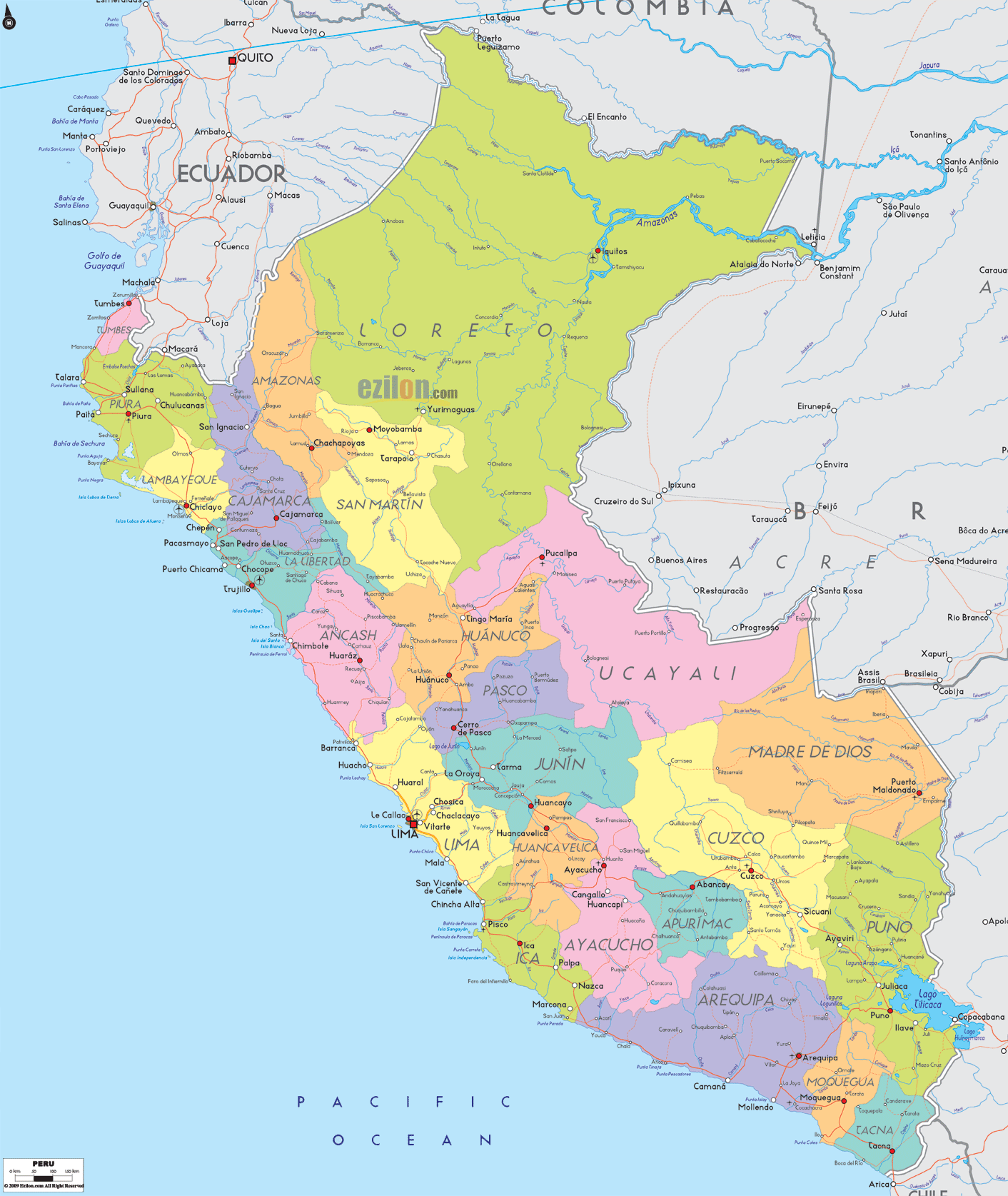
Description: Detailed large political map of Peru showing names of capital city, towns, states, provinces and boundaries with neighbouring countries.
 Map of Peru, featuring cities, major cities, provinces, and a road network. Detailed map. Best map. Use this easy guide to read the image like a local. We move along the coast, climb the Andes, and cross into the Amazon so you can quickly find each department, its main cities, nearby borders, and the simple road-light corridors that link them.
Official name: Republic of Peru
Capital: Lima on the Pacific coast, next to Callao port
Map regions: 24 departments plus the Constitutional Province of Callao and the Lima province for the capital area
Population: about 34 million, with most people along the coast and the Andean valleys
Languages: Spanish is the official nationwide language; Quechua and Aymara are official in many Andean areas
Currency: Sol (PEN)
Time zone: UTC minus 5
The highest city on this map, Cerro de Pasco, sits above 4300 meters on the plateau
Famous places you can locate: Cusco, Machu Picchu valley near the Urubamba, Nazca lines area by Ica, Lake Titicaca by Puno, Colca Canyon near Arequipa
Why this map helps: the color blocks and river lines make it simple to plan routes across the coast, Andes, and Amazon.
Peru sits on the Pacific Ocean with five neighbors. Ecuador and Colombia touch the far north. Brazil has a long eastern border across the Amazon Basin. Bolivia meets Peru at Lake Titicaca in the southeast. Chile borders the far south. The red square marks Lima, the national capital, on the central coast next to Callao port.
Tumbes is a small coastal department on the Ecuadorian coast. The town of Tumbes sits near mangroves and the Pan-American corridor crossing from Ecuador.
Piura is directly south of the cities Piura, Paita, and Talara on the map. Sandy beaches and desert plains make this an easy stretch to follow.
Lambayeque holds Chiclayo inland from the coast, plus Lambayeque and Pimentel by the shore.
La Libertad shows Trujillo on the sea with Pacasmayo and Huanchaco nearby. This is a clear section of the coastal highway.
Ancash marks Chimbote on the bay and the inland Andean city Huaraz below the Cordillera Blanca.
The Lima region wraps around the capital district. On the shoreline, you can spot Huacho, Chancay, and Pisco. The red square labels Lima. Next to it sits Callao, the main port with the airport symbol close by.
Ica includes Pisco, Ica, and the famous Nazca area inland. The road-light line hugs the desert coast here.
Arequipa shows the large inland city of Arequipa with the port of Matarani on the coast.
Moquegua places Ilo on the sea and the inland.
Tacna is the southern tip of the Chile line. Tacna city is just inland with a marked border road down to Arica in Chile.
Cajamarca rises above the coast with Cajamarca city and routes toward Cutervo and Jaén.
Amazonas sits east of Cajamarca. Chachapoyas is marked on the mountain shelf.
San Martín is the green gateway to the jungle. Moyobamba and Tarapoto are easy to find on the interior corridor that links to the lowlands.
Huánuco highlights Huánuco and Tingo María on the road toward the jungle.
Pasco shows Cerro de Pasco high on the plateau. Watch the central highway line that climbs from Lima to La Oroya, then splits to Pasco and Junín.
Junín centers on Huancayo, with La Oroya as the key junction where routes to Lima, Pasco, and Huancavelica meet.
Huancavelica sits just south of Junín. The label Huancavelica shows this quiet highland seat connected by a spur road.
Ayacucho is situated in a broad valley, with roads leading to Huancavelica, Apurímac, and Ica.
Apurímac shows Abancay and Andahuaylas on tight mountain curves.
Cusco (often written Cuzco on maps) is a large department with Cusco city, plus Sicuani, Quillabamba, and routes toward the Machu Picchu valley.
Puno sits on Lake Titicaca. Puno and Juliaca are the main hubs with roads to Desaguadero at the Bolivia line.
Arequipa, Moquegua, and Tacna, already noted on the coast, also climb into high plateaus inland.
Loreto dominates the north and northeast. Iquitos stands out on the Amazon River and is reachable mainly by river or air. You will also see Yurimaguas, Nauta, and many river bends.
Ucayali sits south of Loreto, with Pucallpa marked on the Ucayali River and road-light links west to Tingo María and Huánuco.
Madre de Dios in the southeast shows Puerto Maldonado on the Interoceanic Highway to Brazil.
Ucayali, Pasco, and Huánuco together form the central jungle slope where roads drop from the Andes into the basin.
Ecuador touches Tumbes, Piura, Cajamarca and Amazonas.
Colombia borders Loreto across wide Amazon channels.
Brazil borders Loreto, Ucayali, and Madre de Dios, with the named Brazilian states of Acre and Amazonas lying across the line.
Bolivia borders Puno along Lake Titicaca and the southeast land boundary.
Chile touches Tacna at the very south.
The Pan-American Highway runs from Tumbes to Tacna. On the map it links Tumbes, Piura, Chiclayo, Trujillo, Chimbote, Huacho, Lima–Callao, Pisco, Ica, Nazca, Arequipa, Ilo, and Tacna. Use the red line and the repeating seaside towns to keep your place.
Lima to Junín and the plateau: climb from Lima up the central road through La Oroya. From here, one branch goes to Huancayo in Junín, another to Cerro de Pasco, and a third down to Huancavelica and Ayacucho.
Cusco to Puno: follow the Andean route Cusco–Sicuani–Juliaca–Puno, then east to the Bolivian line.
Cusco to Madre de Dios: the Interoceanic Highway crosses the Andes to Puerto Maldonado and continues toward Brazil.
Huánuco to Pucallpa: a clear road-light link drops from Tingo María east to Pucallpa in Ucayali.
San Martín to Loreto: from Tarapoto and Moyobamba, corridors run to Yurimaguas and on by river toward Iquitos.
Amazon rivers: the Marañón, Huallaga, and Ucayali join near Iquitos to form the Amazon. On the map, those blue lines are your best guide to town locations in the north jungle.
Big colored names show departments. Red dots mark main cities. The red square marks the capital Lima. Coastal towns repeat often and help you measure distance. In the Andes, look for junction towns like La Oroya, Huancayo, Abancay, Ayacucho, Juliaca, and Cusco. In the jungle, anchor in river cities such as Iquitos, Pucallpa, and Puerto Maldonado.

Physical Map of Peru
Physical map and map image of Peru.

Regional Directory of South America
Information and guide about South America and website listing.

Regional Directory of United States of America
Information and guide about United States of America and websites with American topics.

Regional Directory of Europe
Information and guide about Europe and websites with European topics.

Regional Directory of Australia
Information and guide about Australia and websites with Australian topics.