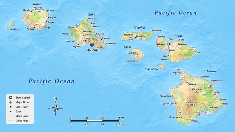
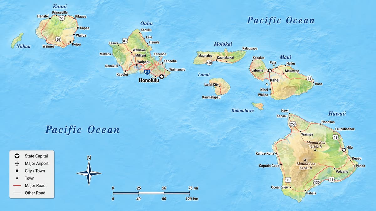
Description: Detailed large map of Hawaii State, USA showing cities, towns, county formations, highways, and State routes.
 Map of Hawaii (USA). Hawaii map with cities, counties, and towns. Use this detailed map to understand Hawaii's full county grid, every administrative capital (county seat), the major cities and towns, bordering states and waters, and a few highway cues for orientation only. It is the best map style for residents, travelers, and geography students who want clarity without road clutter.
Hawaii is really an island-first map more than a county-first one, since here the two nearly line up. Four of the five counties are simply island groups given a government: Oahu is Honolulu County, the Big Island carries the name Hawaii County outright, and Kauai County gathers Kauai together with its smaller western neighbors. Maui County breaks that pattern, stitching four separate islands under one seat. Then there's Kalawao, the fifth and smallest county, a narrow shelf of land on Molokai's north shore with no elected government of its own, a quiet nod to its past as a settlement for people with Hansen's disease. Everything practical about that structure lands on the map itself: five counties, their seats, the cities and towns you would actually visit, and just enough highway detail, nearly all of it on Oahu, to get your bearings without crowding the page.
Borders and waters at a glance: The Pacific Ocean wraps around every county here, and Hawaii is the only state in the country with no land border to cross into another. Follow the island chain on the map from Northwest to Southeast and you pass Niihau and Kauai (Kauai County), then Oahu (Honolulu County), then Molokai, Lanai, Maui, and Kahoolawe (all Maui County, apart from the Kalaupapa Peninsula), before finishing at the Big Island (Hawaii County) out at the Southeast end of the chain. The Kaiwi Channel marks the gap between Oahu and Molokai, and the Alenuihaha Channel, one of the roughest stretches of open water anywhere in the islands, separates Maui from the Big Island.
Road-light orientation: Oahu is the only island carrying interstate-numbered routes. H-1 runs the length of the Southern shore, from Kapolei through Honolulu out to Hawaii Kai. H-2 breaks off north from Pearl City toward Wahiawa and Schofield Barracks in the island's Central plateau. H-3 tunnels straight through the Koolau Range, linking Pearl Harbor to Kaneohe on the Windward side. Out on the neighbor islands, the Hawaii Belt Road rings the Big Island, the Hana Highway follows Maui's Northeast coast, and the Kuhio Highway traces Kauai's north and east shore. None of these are here to give directions, just to help you follow along as you move from one county to the next.
Hawaii sits alone in the central Pacific, roughly 2,400 miles from the nearest continental shore, with the Pacific Ocean on every side and no bordering states at all. The map shows 5 counties: Hawaii, Honolulu, Maui, Kauai, and tiny Kalawao. Hawaii County, coextensive with the Big Island, is the largest by land area at about 4,028 square miles, while Kalawao County is the smallest, at about 12 square miles, also the smallest county anywhere in the United States. Honolulu County is by far the most populous, with over a million residents, close to 70 percent of the entire state, while Kalawao County has the fewest, with roughly 82 people. All five counties share the same founding year, 1905, carved from the Territory of Hawaii. Hawaii's total land area runs about 6,423 square miles, with total area near 10,931 square miles once the ocean within its boundaries is counted. The capital, Honolulu, sits in Honolulu County on Oahu's south shore, and the ten largest cities by population are Honolulu, East Honolulu, Hilo, Pearl City, Waipahu, Kailua, Kaneohe, Ewa Gentry, Mililani Town, and Kahului.
Hawaii–Hilo; Honolulu–Honolulu; Kalawao–no seat, administered by the state Department of Health; Kauai–Lihue; Maui–Wailuku. Honolulu County's seat, Honolulu, also serves as the state capital, and Kalawao remains the one county in the country without a local government of its own.
Honolulu County covers the whole of Oahu, plus a scatter of nearly uninhabited islands trailing Northwest across the Pacific. Look at the map's Southern shore and it reads almost as one continuous urban run: Honolulu itself, with Waikiki as its famous beachfront district, then Pearl City, Aiea, and Waipahu circling Pearl Harbor, and East Honolulu stretching out toward Hawaii Kai. Inland and to the West, Kapolei has grown into Oahu's second city, with Ewa Beach, Ewa Gentry, and Makakilo filling the plain beneath the Waianae Range. H-1 threads all of it together from Kapolei to Hawaii Kai, and H-2 splits off near Waipahu toward the island's Central interior.
Cross the Koolau Range, whether by H-3 or the older Pali and Likelike highways, and the map opens onto the Windward side: Kaneohe, Kailua, and Waimanalo line the coast beneath a wall of green cliffs. Central Oahu holds Mililani Town, Mililani Mauka, and Wahiawa near Schofield Barracks, while the North Shore, known for its winter surf, keeps smaller towns like Haleiwa, Waialua, and Kahuku. The Northwestern Hawaiian Islands belong to Honolulu County too, though they sit far off the map to the Northwest and stay essentially uninhabited outside of researchers and refuge staff.
Hawaii County, seat Hilo, is coextensive with the Big Island and by far the largest of the five, its land alone covering close to two-thirds of the entire state. Hilo anchors the wetter Eastern side, close to Hawaii Volcanoes National Park and the twin summits of Mauna Kea and Mauna Loa. Head over to the drier Western, or Kona, side and Kailua-Kona takes over as the visitor and commerce hub, with Waimea (Kamuela) up in ranching country to the North, and Pahoa and Naalehu, the southernmost town in the entire United States, down toward the South. The Hawaii Belt Road rings the whole island, tying these towns together without ever turning into a true highway network.
Maui County, seat Wailuku, is the one county built from four separate islands instead of one. On Maui itself, Kahului is the largest town and the island's commercial center, sitting right beside Wailuku near the airport; Kihei and Wailea line the sunny Southern shore, and Lahaina anchors the Western side near Kaanapali. Climb up onto Haleakala's slopes and you find Makawao, Pukalani, and Kula keeping a cooler, more rural feel, while Hana sits out at the end of the winding Hana Highway on the remote Eastern coast. Across the channel, Molokai holds the small town of Kaunakakai, and Lanai has just one real town, Lanai City. Kahoolawe, the county's fourth island, is uninhabited and managed today as a cultural reserve.
Kalawao County sits on the isolated Kalaupapa Peninsula along Molokai's North shore, cut off from the rest of the island by some of the tallest sea cliffs anywhere on Earth. It has no county seat and no elected government at all; the state Department of Health runs it directly, a legacy of the peninsula's decades as a settlement for people with Hansen's disease, from 1866 to 1969. Its only community, Kalaupapa, now sits inside Kalaupapa National Historical Park, reachable only by air or by a steep mule trail down the cliffs.
Kauai County, seat Lihue, brings together the oldest main island in the chain along with privately owned Niihau off to the West. Kapaa, on the Eastern coast, is Kauai's largest town, with Lihue nearby serving as the government and airport hub. The Kuhio Highway follows the North and East shore through Kilauea and Hanalei before running out at the base of the Na Pali Coast, while the Kaumualii Highway covers the South and West side through Koloa, Poipu, and Waimea, the gateway to Waimea Canyon.
Six named channels do most of the orientation work between islands on this map. The Kaiwi Channel separates Oahu from Molokai. The Pailolo Channel runs between Molokai and Maui, and the Auau Channel splits Maui from Lanai. The Alalakeiki Channel divides Maui from Kahoolawe, and the Alenuihaha Channel, notoriously rough, separates Maui from the Big Island out to the Southeast. The Kauai Channel is the widest gap of them all, keeping Kauai and Niihau apart from Oahu to the Northwest. Learn those six and any island on this map becomes easy to place.
The highway layer stays intentionally light across this whole map. H-1, H-2, and H-3 cover Oahu only, and despite the interstate numbering, none of the three ever leaves the island. The Hawaii Belt Road (Routes 11, 19, and 190) rings the Big Island. The Hana Highway and Honoapiilani Highway cover Maui's Eastern and Western sides. The Kuhio and Kaumualii highways split Kauai's Northeast and Southwest shores between them. None of these are meant for turn-by-turn navigation, just as cues for placing a county.
Residents can place their neighborhood inside a clear county frame and immediately see which island, and which town on that island, sits closest by. Travelers get a fast way to track which county they are flying or driving into, since island-hopping in Hawaii means crossing an entire county line every single time. And geography students pick up the five-county structure fast, along with the genuine quirk of Kalawao County, a real county with no government of its own at all, sitting quietly on a map otherwise built around cities, seats, and coastlines.
On this map, Mauna Kea and Mauna Loa in Hawaii County, along with Haleakala in Maui County, double as quick landmarks for finding a county, right alongside the channels separating each island. For elevation, terrain, watersheds, and land-cover detail, see our Physical Map of Hawaii.
Hawaii's ten largest cities by current population are Honolulu (about 340,000, Honolulu County), East Honolulu (about 51,000, Honolulu County), Hilo (about 49,000, Hawaii County), Pearl City (about 44,000, Honolulu County), Waipahu (about 40,000, Honolulu County), Kailua (about 40,000, Honolulu County), Kaneohe (about 36,000, Honolulu County), Ewa Gentry (about 28,000, Honolulu County), Mililani Town (about 27,000, Honolulu County), and Kahului (about 27,000, Maui County). Tourism carries much of the state's economy, from Waikiki's hotel corridor in Honolulu County down to the resort belts of West Maui and the Kohala Coast in Hawaii County. The military keeps a major footprint on Oahu around Pearl Harbor, Hickam, and Schofield Barracks, and farming, once dominated by sugar and pineapple, has shifted toward Kona coffee, macadamia nuts, and diversified fruit and vegetable operations across the neighbor islands. Honolulu Harbor remains the state's main commercial port, taking in the bulk of goods shipped from the mainland before smaller barges carry cargo out to the other islands.
Native Hawaiian culture shapes the map's place names and landmarks alike. Iolani Palace and Chinatown anchor historic Downtown Honolulu in Honolulu County, and Pearl Harbor National Memorial pulls in visitors from all over the world. Hawaii Volcanoes National Park, in Hawaii County, protects two of the most active volcanoes on Earth and remains central to Native Hawaiian tradition. Kalaupapa National Historical Park, in Kalawao County, preserves the story of the peninsula's settlement and the compassion of caregivers like Father Damien and Mother Marianne Cope. Higher education centers on the University of Hawaii at Manoa in Honolulu, with additional campuses on the Big Island, Maui, and Kauai. Outrigger canoe paddling, slack-key guitar, and hula stay living traditions practiced across every county, not confined to any single island.
Hawaii runs a tropical climate with warm temperatures all year, though rainfall swings sharply between an island's wet, Windward side and its dry, Leeward side, and high elevations like Mauna Kea can even catch snow. For the full seasonal and biome breakdown, see our Physical Map of Hawaii.
Since no bridges or tunnels connect Hawaii's islands, getting from one county to another almost always means flying or catching an interisland ferry, there is no continuous highway system tying them together the way the mainland has. Within Oahu, H-1 works as the main East-West spine, with H-2 and H-3 branching North-South off of it. On the neighbor islands, a single belt road or highway usually covers the ground: the Hawaii Belt Road on the Big Island, the Hana and Honoapiilani highways on Maui, and the Kuhio and Kaumualii highways on Kauai. Keep in mind that ZIP codes do not always line up neatly with county borders here either, so confirm the county name straight from the map or the index rather than assuming it from a ZIP prefix.
Five: Hawaii, Honolulu, Maui, Kauai, and Kalawao counties.
Not exactly. Oahu is Honolulu County and the Big Island is Hawaii County, but Maui County spans four islands and Kauai County spans two.
A tiny fifth county on part of Molokai with no elected government; the state Department of Health administers it directly.
Honolulu, in Honolulu County on the island of Oahu.
Honolulu County, which covers the entire island of Oahu.
Hawaii County, on the Big Island.
Maui County.
Kauai County.
Molokai, on the isolated Kalaupapa Peninsula.
Hilo.
Honolulu, which also serves as the state capital.
Wailuku.
Lihue.
No. It has no elected government, and its only settlement is Kalaupapa.
Maui, Molokai (except the Kalaupapa Peninsula), Lanai, and Kahoolawe.
Kauai, Niihau, Lehua, and Kaula.
Oahu, plus the Northwestern Hawaiian Islands other than Midway Atoll.
H-1, H-2, and H-3 on Oahu; the Hawaii Belt Road on the Big Island; the Hana and Honoapiilani highways on Maui; and the Kuhio and Kaumualii highways on Kauai.
No. H-1, H-2, and H-3 are federally numbered Interstate Highways, but all three stay entirely within Oahu.
Hawaii County, at about 4,028 square miles.
Kalawao County, at about 12 square miles, the smallest county in the entire United States by land area.
Honolulu County, with over 1 million residents, roughly 70 percent of the entire state.
Kalawao County, with about 82 residents.
Honolulu, in Honolulu County, with roughly 340,000 residents.
All five counties share the same founding year, 1905, when they were organized from the Territory of Hawaii.
A beachfront neighborhood within Urban Honolulu, in Honolulu County.
On the west side of Hawaii County, the Big Island.
On the west side of the island of Maui, in Maui County.
On the west side of the island of Kauai, in Kauai County.
On the island of Maui, in Maui County; it is the island's dormant volcanic summit.
In Hawaii County, on the Big Island, inside Hawaii Volcanoes National Park.
The Pacific Ocean surrounds every county; Hawaii has no land border with any other state.
No. ZIP codes do not always align with county lines here, so use the county boundaries and seats shown on the map instead.
No. Printing or copying maps from this site is not permitted.

Physical Map of Hawaii
Physical map and map image of Hawaii.

Regional Directory of Canada
Information and guide about Canada and website listing.

Regional Directory of United States of America
Information and guide about United States of America and websites with American topics.

Regional Directory of Europe
Information and guide about Europe and websites with European topics.

Regional Directory of Australia
Information and guide about Australia and websites with Australian topics.
