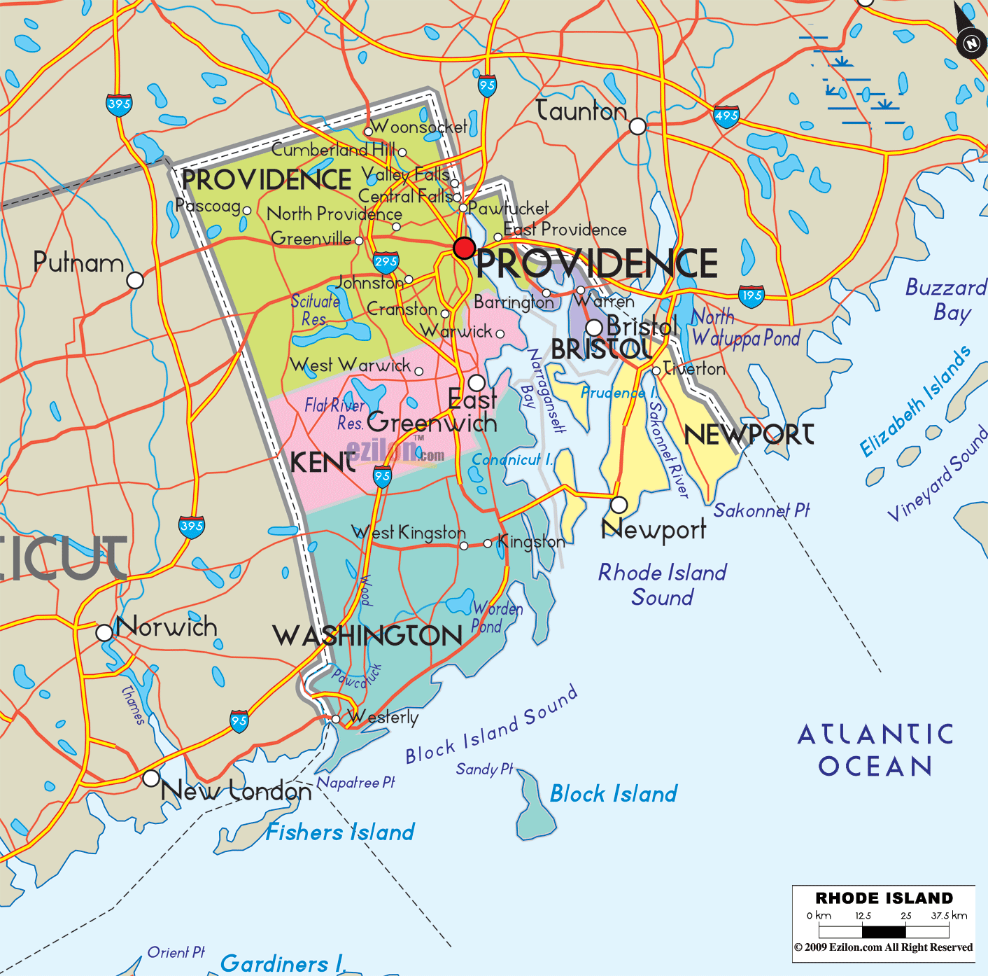

Description: Detailed large map of Rhode Island State, USA showing cities, towns, county formations, roads highway, US highways and State routes.
 Use this detailed map of Rhode Island to explore every county, the major cities and towns, shoreline islands, and a few clean highway cues for quick orientation. The focus is the whole grid of counties and their principal hubs, not a tangle of roads. Where Rhode Island counties no longer operate county government, we still note the long-recognized county centers as shown on the map so readers can locate the leading communities at a glance.
Borders and waters: Massachusetts lies to the north and east. Connecticut borders the west. The south opens to Narragansett Bay, Rhode Island Sound, Block Island Sound, and the Atlantic Ocean.
Road-light orientation: just a few anchors help you track movement without clutter. I-95 runs southwest to northeast from Westerly through South Kingstown, Warwick, Cranston, Providence, and Pawtucket, then on to Massachusetts. I-195 leaves Providence toward East Providence and Fall River. I-295 loops around the west side of the metro. RI-4 drops from Warwick toward the South County beaches. Bridges that matter visually are the Newport Pell Bridge and Jamestown Verrazzano Bridge over the East Passage, the Mount Hope Bridge to Bristol County, and the Sakonnet River Bridge to Tiverton.
County center on the map: Providence. Why it stands out: This is the state’s population core around the upper Narragansett Bay and Providence River. The map shows a tight cluster of municipalities that together read as the Providence metro.
Primary cities and towns you can locate at once
Providence sits on the river head with College Hill and downtown labels.
Cranston is immediately south of Providence.
Pawtucket and Central Falls lie to the northeast near the Massachusetts line.
East Providence sits on the east bank, tied to I-195 and the East Bay.
North and west of the capital, the map shows Woonsocket on the Blackstone River, plus North Providence, Johnston, Smithfield, Lincoln, Cumberland, North Smithfield, Burrillville, Glocester, and Foster.
How to follow the county on the map: Trace I-95 through Warwick and Cranston into Providence, then continue to the Pawtucket cluster. Swing west along the I-295 arc to catch Johnston, Smithfield, and Lincoln. Use the Blackstone River to spot Woonsocket at the north edge. The municipal pattern makes the densest texture on the map, confirmed by the thicker settlement dots.
County center on the map: East Greenwich (traditional county seat). Where it sits: Immediately southwest of Providence County, bordering the West Bay of Narragansett Bay.
Cities and towns are labeled
Warwick is the big name on the bay, hosting the state’s primary airport in the city limits.
West Warwick lies inland along the Pawtuxet River valley.
Coventry stretches to the Connecticut boundary and touches the I-395 approach by way of secondary state routes.
East Greenwich fronts Greenwich Bay with a historic main street.
West Greenwich occupies the wooded southwest where I-95 crosses the county line.
Orientation tip: Find Greenwich Bay and the notch of Apponaug and Warwick Neck. Slide west along the Pawtuxet valley dots to West Warwick and Coventry. The southern boundary meets Washington County, where the coastal plain widens toward South County beaches.
County center on the map: South Kingstown, with Kingston shown inland. Local nickname: South County. Geography that jumps off the page: the county wraps the south coast and the West Bay islands while reaching almost to the Connecticut line in the west.
Towns and villages to read on the map
South Kingstown, with Kingston inland and Wakefield–Peacedale closer to the coast.
Narragansett on the East Passage and the Point Judith area.
Westerly at the far southwest corner along the Pawcatuck River opposite Stonington, CT.
Charlestown, Richmond, and Hopkinton across the inland woodlands.
Exeter forms the northeastern corner bordering Kent County.
Offshore, the map highlights Block Island (Town of New Shoreham) in Block Island Sound, a key label for the county.
How to trace it: Follow RI-4 south from Kent County. It opens into US-1 near the beaches. The bright coastline labels in Narragansett, Matunuck, and Point Judith frame the ocean edge. Use the dashed ferry line to see the linkage to Block Island.
County center on the map: Newport. Why is it easy to spot: It is the island county. The labels line the East Passage of Narragansett Bay on Aquidneck Island and Conanicut Island.
Main places the map calls out
On Aquidneck Island: Newport, Middletown, Portsmouth, with coastal points like Sakonnet Point and Third Beach.
On Conanicut Island: Jamestown, connected by the Jamestown Verrazzano Bridge west to Washington County and the Newport Pell Bridge east to Newport.
Along the Sakonnet River and East Bay: Tiverton and Little Compton at the Massachusetts line.
Small islands such as Prudence Island also fall within the county’s maritime footprint through the Town of Portsmouth.
Reading the county, Start at the Newport Pell Bridge arching over the East Passage between Jamestown and Newport. Move north along Aquidneck to Middletown and Portsmouth, then cross the Sakonnet River Bridge into Tiverton. The county’s outline tracks water on three sides, which you can see clearly from the heavy bay labels.
County center on the map: Bristol. Character on the map: the smallest Rhode Island county, hugging the mainland east of Providence with a narrow peninsular shape into Mount Hope Bay.
Places to spot immediately
Bristol with its historic waterfront.
Warren is just north along the river mouth.
Barrington on the landward side near the East Providence line.
The Mount Hope Bridge links Bristol to Portsmouth on Aquidneck, serving as a vital connection between East Bay and the islands.
How to navigate it visually: Find East Providence on the east bank of the Seekonk and Providence Rivers. Slide southeast along the coastline dots to Barrington, then down to Warren, then to Bristol, jutting into Mount Hope Bay.
Narragansett Bay splits into West Passage and East Passage, labeled from Warwick Neck down to Beavertail and Newport.
The Sakonnet River separates Portsmouth, Tiverton, and Little Compton from the mainland.
Mount Hope Bay sits between Bristol and Fall River, Massachusetts.
Rhode Island Sound and Block Island Sound frame the open ocean south of Point Judith and Block Island.
The Providence River carries the capital’s waterfront down into the bay.
Providence County wraps the inland headwaters and metro core.
Kent County controls the West Bay shore and the inland forest corridor to Connecticut.
Washington County replaces Kent as you move south and west, then extends along the Atlantic beaches and out to Block Island.
Newport County occupies the islands and the East Bay towns that face Bristol County across the inland seas.
Bristol County forms the slim East Bay peninsula between East Providence and Portsmouth.
West side: Connecticut, with cross labels at Westerly, Hopkinton, and Coventry.
North and east: Massachusetts, visible at Pawtucket, Woonsocket, East Providence, Attleboro, and the Fall River area opposite Tiverton and Portsmouth.
South: open water to Rhode Island Sound and Block Island Sound.
Providence County, Cranston, Pawtucket, East Providence, Central Falls, Woonsocket, North Providence, Johnston, Lincoln, Cumberland, North Smithfield, Smithfield, Scituate, Foster, Glocester, Burrillville.
Kent County: Warwick, West Warwick, East Greenwich, Coventry, West Greenwich.
Washington County, South Kingstown, Kingston, Narragansett, North Kingstown, Charlestown, Richmond, Hopkinton, Westerly, Exeter, New Shoreham on Block Island.
Newport County Newport, Middletown, Portsmouth, Jamestown, Tiverton, Little Compton, and Prudence Island communities.
Bristol County, Bristol, Warren, Barrington.
I-95 is your universal spine. If you can see I-95 on the map, you can place nearly every inland community from Westerly to Pawtucket.
I-195 tells you which towns flow east from Providence into Massachusetts.
I-295 marks the outer west metro arc where Johnston, Smithfield, and Cumberland cluster.
RI-4 and US-1 point south into Washington County’s towns, beaches, and ferry connections.
Bridge icons cue the East Bay and islands without adding clutter.
County system context: Rhode Island’s five counties have no active county governments today. The county names remain as important geographic references, and the map treats them that way, highlighting each county’s principal communities as the effective administrative centers.
Urban pattern: Providence County is home to the largest cities. Kent and Washington counties transition from inner suburbs and airport access to rural forests and beaches. Newport and Bristol counties are organized around harbors, islands, and peninsulas.
Shoreline and islands: The county layout mirrors the bay. Newport County rides the East Passage and islands. Kent County covers the West Bay. Washington County encompasses the oceanfront and offshore areas of Block Island.
Neighbor awareness: Many Rhode Island commuters cross into Massachusetts daily. The map’s clean connections to Taunton, Attleboro, and Fall River make sense of the regional economy without taking focus off the counties.
Map-reading rhythm: Start with the county label in uppercase, then find the bold city name that acts as the county’s hub, then use a single highway or bridge name to confirm position.
Providence County – Providence
Kent County – East Greenwich
Washington County – South Kingstown with Kingston hub
Newport County – Newport
Bristol County – Bristol

Physical Map of Rhode Island
Physical map and map image of Rhode Island.

Regional Directory of Canada
Information and guide about Canada and website listing.

Regional Directory of United States of America
Information and guide about United States of America and websites with American topics.

Regional Directory of Europe
Information and guide about Europe and websites with European topics.

Regional Directory of Australia
Information and guide about Australia and websites with Australian topics.