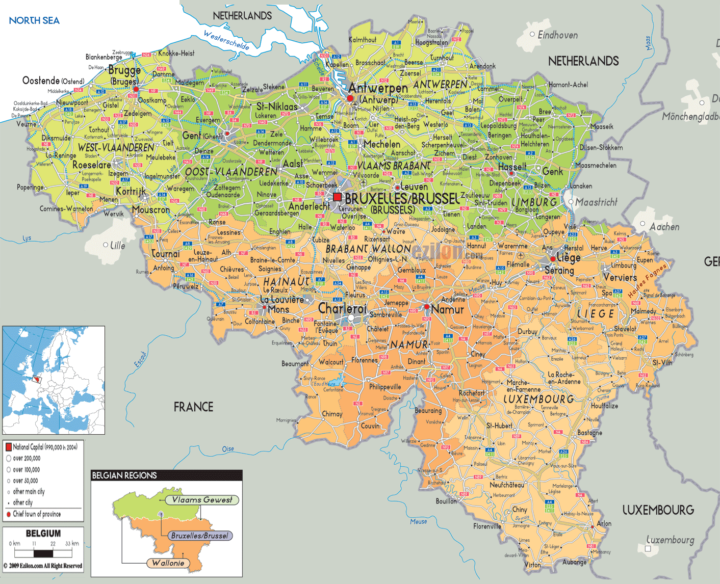
Description: Detailed large political map of Belgium showing names of capital cities, towns, states, provinces and boundaries with neighbouring countries.

Map of Belgium, Belgium map with cities, major cities, and road network are the main search phrases this page is built around. Our detailed map of Belgium shows the whole country at a glance, with the three regions, every province, major towns, highways and rail lines, borders with France, the Netherlands, Germany and Luxembourg, and the short North Sea coastline.
This guide walks you through the sheet as if we were following the Belgium map together, making it useful for residents, travelers, and geography students who want the best map-style explanation rather than just a static image.
Belgium is a compact Western European country at the meeting point of Latin and Germanic cultures. The map shows how Flanders fills the north in green, Wallonia covers the south in orange, and the Brussels Capital Region stands as a small central island. Around the edges, you see neighbouring countries clearly labelled: France to the southwest, the Netherlands to the north and northeast, Germany to the east, and Luxembourg to the southeast. The North Sea touches the northwest, giving Belgium its narrow coastal strip.
Our Belgium map with cities colours the three regions so you can read them instantly:
Vlaams Gewest (Flemish Region) is in green across the north.
Wallonie (Walloon Region) is in orange across the south.
Bruxelles / Brussels (Brussels-Capital Region) has a small, dark inset in the centre.
Within these regions, the detailed map breaks Belgium into ten provinces, each with a chief town marked by a special symbol:
In Flanders: West-Vlaanderen, Oost-Vlaanderen, Antwerpen, Vlaams-Brabant, Limburg.
In Wallonia: Hainaut, Brabant Wallon, Namur, Liège, Luxembourg.
The inset at the bottom right of the sheet repeats this structure in a small "Belgian regions" diagram, which helps new readers connect the colours on the main image with the political units.
On the outer frame, our detailed map of Belgium labels nearby cities in adjacent countries: Lille and Paris in France, Eindhoven, Maastricht, and Amsterdam in the Netherlands, Aachen and Düsseldorf in Germany, and Luxembourg City in Luxembourg. Main roads from Belgian cities such as Antwerp, Liège, and Namur lead to these external centers, underscoring Belgium's role as a crossroads in Western Europe.
For geography students, this border detail is critical because it demonstrates how the Scheldt, Meuse, and Sambre river basins, along with dense road and rail networks, make Belgium part of the busy North Sea corridor between France, the Netherlands, and Germany.
On the left of the map, the North Sea is shown with a wavy blue line, and the coastal towns of Oostende (Ostend), Blankenberge, Knokke-Heist, and De Panne are marked along the shoreline. The area falls under the province of West-Vlaanderen (in green). Oostende, Kortrijk, and Gent are well linked by road to Brugge, the main town of West Flanders.
Further south, you see Kortrijk, Roeselare, Ieper, Tielt, and smaller towns such as Veurne and Poperinge, all connected by a web of regional roads. This part of the Belgium map with cities makes it easy to trace routes between the coast, the French border around Lille, and inland Flanders.
On the left of the map, the North Sea is shown with a wavy blue line, and the coastal towns of Oostende (Ostend), Blankenberge, Knokke-Heist, and De Panne are marked along the shoreline. The area falls under the province of West-Vlaanderen (in green). Oostende, Kortrijk, and Gent are well linked by road to Brugge, the main town of West Flanders.
For residents and visitors, this section of the map is a practical tool for planning day trips between medieval cities, canal towns, and industrial ports. For students, the cluster of labels along the Scheldt valley illustrates why this lowland corridor has long been one of Flanders' economic engines.
North of Brussels, coloured in slightly lighter green, sits Antwerp Province. The city of Antwerpen (Antwerp) is marked in bold near the Scheldt estuary. From Antwerp, roads radiate to Mechelen, Turnhout, Sint-Niklaas, and across the border into the Netherlands toward Breda and Eindhoven. The port area is sketched along the wide tidal river, reminding map readers that Antwerp is one of Europe's largest seaports.
Nearby towns such as Lier, Herentals, and Geel are also easy to locate. When you follow the road lines between them, you understand how the Antwerp hinterland supports logistics, chemicals, metal industries, and commuter belts. This is one of the most densely connected parts of the detailed map of Belgium.
East of Brussels and Leuven, the green shading continues into Vlaams-Brabant and Limburg. Cities such as Leuven, Hasselt, Genk, and Tongeren appear, with roads stretching toward Maastricht in the Netherlands and Aachen in Germany. Forest symbols and river lines hint at the Kempen landscape and the Meuse valley.
For travelers using our Belgium map with cities, this eastern Flanders zone is ideal for cycling routes between university towns, mining heritage sites, and cross-border nature parks.
In the centre of the sheet, the Bruxelles/Brussel label stands out against a compact dark zone. This is the Brussels-Capital Region, which hosts both the Belgian federal institutions and the European Union's headquarters. Surrounding municipalities merge into the urban fabric, and the map shows dense road and rail lines entering Brussels from all directions.
Key nearby towns in Vlaams-Brabant, such as Zaventem, Vilvoorde, Dilbeek, Halle, and Leuven, are all within a short distance of Brussels. The detailed map makes clear how Brussels serves as the central node in both a national and an international network, linking north to Antwerp, west to Ghent and Bruges, east to Liège, and south to Charleroi and Namur.
Southwest of Brussels, the map colours Hainaut Province in orange. Its chief town, Mons, stands near the French border, and important cities such as Charleroi, Tournai, La Louvière, and Mouscron are also marked. Many roads run parallel to the Franco-Belgian border and connect to French towns such as Lille and Valenciennes.
The Sambre valley through Charleroi and the former coal basin appear as a dense cluster of place names. This part of the Belgium map with cities shows how Wallonia's industrial belt lines up along rivers and east-west road corridors.
The map shows the Brabant Wallon region, with Wavre as its capital, just south of Brussels. Towns like Nivelles, Waterloo, and Ottignies-Louvain-la-Neuve are so close to the capital region that they may as well be part of it, but they're in Wallonia. The roads of these towns go back to Brussels and out towards Namur and Charleroi.
Further southward from the above, the next notable province is Namur, with Namur as the capital at the junction of the Meuse and Sambre rivers. This large, detailed map of Belgium shows that Namur lies at the intersection of roads from Liège in the northeast, Charleroi in the west, and Luxembourg in the southeast. Towns like Dinant, Ciney, and Andenne are there in the Meuse valley, which marks the entrance to the hills of Ardennes.
In the eastern part of Wallonia, you reach Liège Province. Liège is a big name in the Meuse – roads lead to Verviers, Huy, Seraing, Eupen, and the German border. The topographic map illustrates how the Meuse cuts a valley corridor through the hills, while the Vesdre Valley branches toward the High Fens and Germany.
This part of the Belgium map with cities is particularly valuable for travelers who want to explore industrial heritage, hill towns, and cross-border landscapes. This also shows the German-speaking community around Eupen and Sankt Vith, which is relevant for the linguistic geography of Belgium.
In the southeast corner, the sheet shades Luxembourg Province in orange. Towns such as Arlon, Bastogne, Marche-en-Famenne, La Roche-en-Ardenne, and Bouillon dot a forested plateau. Roads run south toward Luxembourg City and east toward Germany, while smaller routes weave through the valleys of the Semois and Ourthe rivers.
Due to the hilly, open terrain, the road network appears denser than in Flanders. To map readers, the contrast between the dense northern plains and the southern uplands of Belgium is so evident that the detailed map of the country makes it clear how relief shapes settlement and transport.
Residents can use the Belgium map with cities to see how their municipality fits into the national framework. Someone living in Zottegem can reach Gent and Brussels by road. A commuter in Leuven can see quick connections to Brussels, Mechelen, and Hasselt. The coloured provincial boundaries show which chief town handles regional administration.
If any traveller wants to go to any city, they can check the detailed map as an itinerary planner. A standard loop would start in Brussels and go northwest to Brugge and the coast, then east through the Low Countries to Gent and Antwerp, and then southeast to Leuven, Liège, Namur, and the Ardennes, returning via Charleroi or - more likely - Mons. Clean lines map out the roads and railways, distances you must travel, and even pleasant detours along the rivers or through forests.
The Belgium map for geography students and teachers is more than just a tourist map. This fuses language, economic, and transport corridors. This is an example of this. The northern section has Dutch-speaking Flanders and heavy urbanization along the Scheldt and coast. In the south are the French-speaking Wallonia, industrial valleys, and rural highlands. Brussels lies in the centre of Europe and is a bilingual region.
By reading this long explanation while tracing each region, city, and road on our detailed map, users gain a layered understanding of how Belgium's complex structure fits onto a relatively small territory.

Physical Map of Belgium
Physical map and map image of Belgium.

Road Map of Belgium
Road map and map image of Belgium.

Regional Directory of United States of America
Information and guide about United States of America and websites with American topics.

Regional Directory of Europe
Information and guide about Europe and websites with European topics.

Regional Directory of Australia
Information and guide about Australia and websites with Australian topics.