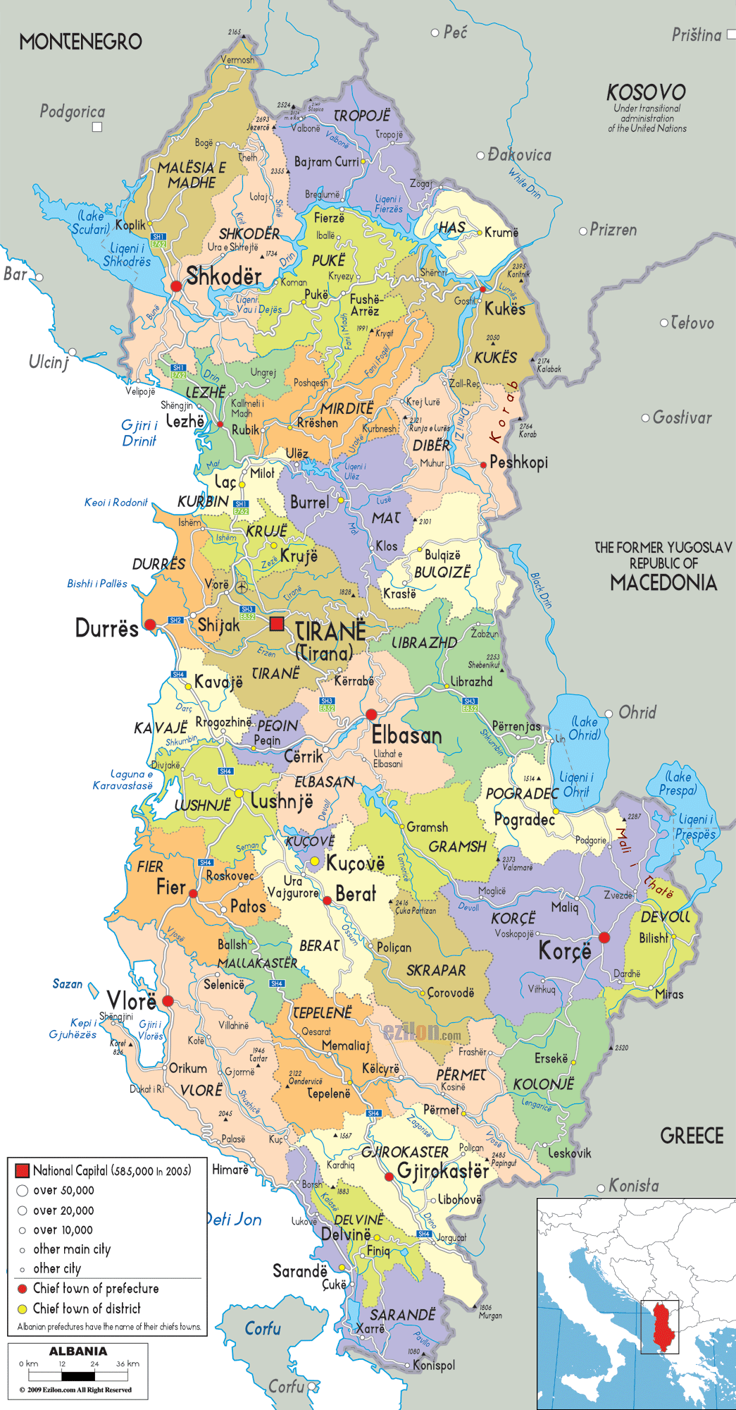
Description: Detailed large political map of Albania showing names of capital cities, towns, states, provinces and boundaries with neighbouring countries.

The political map of Albania above shows all internal regions, major cities, many other towns, and the country's international borders, which lie on the Adriatic and Ionian Seas. A closer view, and it serves as both an Albania map with cities and a learning tool showing how mountains, rivers, and valleys influence settlements.
You can also use the map of Albania, showing regional centers. Labels and dots help you see the hierarchy from the national capital to the local community. Due to its highly detailed nature, this map is valuable for trip planning, geography lesson comprehension, and creating a business or investment context within the country.
This is one of the best map styles for showing Albania's counties, districts, and cities at a glance. Depending on the zoom level, the map provides a clear, understandable image that retains important details without appearing overcrowded. Many travelers and map enthusiasts will agree.
The political map of Albania, at first glance, is divided into colored regions that indicate Albania's principal administrative units. These units were historically known as prefectures and districts, and today they are grouped into 12 counties.
Each shaded area has a main town, indicated by a significant symbol, which serves as the administrative or economic hub of the area. The border between Albania and Montenegro is well-defined and marked on the map. So are the borders with Kosovo, North Macedonia, and Greece. Also marked are the coastlines of the Adriatic and Ionian Seas.
This structure explains to residents which public services they rely on and which regional capital they use. For visitors, it is a handy guide to navigating the coastal resorts, inland valleys, and mountain towns.
The map's legend in the lower corner distinguishes the national capital, prefectural and district chief towns, other main cities, and smaller towns using dot sizes and colors. You'll easily see which places are large regional centers (Tirana, Durres, Shkoder, or Vlore) and which are small but still important connectors such as Puke, Tepelene, or Sarande.
If you follow these symbols dotted throughout the country, you can read the map as a story, starting from the busy coastal plain of Durres, leading up into the highlands near Kukes, then down to Gjirokaster. Consequently, it yields a political map and an orienting tool for those studying the human geography of Albania or planning an overland itinerary.
A map of Albania, located in the Balkan Peninsula, shows it bordered by Montenegro to the northwest, Kosovo to the northeast, North Macedonia to the east, and Greece to the south and southeast. On the west, this coast runs along the Adriatic Sea, from where it turns towards the Ionian Sea. The southern exit to the Adriatic is via the Strait of Otranto.
The map inset shows that, across the Adriatic basin, Albania, opposite Italy, served as a major gateway between the Balkans and the Mediterranean, with ports such as Durres and Vlore historically becoming major gateways.
These boundaries are not simply arbitrary lines. They generally follow mountain ranges and river valleys, as shown on the map. The country is bordered by rugged mountain chains in the north and east; the Albanian Alps and the Korab range are two such ranges. It helps explain why many border crossings concentrate in a few valleys and passes.
In the south, the border with Greece runs through hilly, rugged terrain, while roads and towns such as Sarande and Gjirokaster are located close to the corridors. Following these shapes, a geography student sees how Albania's political outline closely corresponds to its physical geography. Thus, this map is very informative.
Tirana (Tiranë), the national capital, is located slightly west of the map's center. A symbol designates its special status, while the capital has a population over 500,000. Tirana, being the largest city, is marked not only by a bold label but also by the convergence of several main roads that radiate mainly toward Durres, Elbasan, Shkoder, and other large cities.
Tirana is the political, economic, and cultural heart of the country, as well as the starting point for many visitors interested in exploring Albania's cities and towns. This is quite obvious.
The map shows Kamëz and Kavaje in the surrounding area. We also see the coastal plain extending towards the Adriatic Sea. The capital, Durres, links with other towns, but central Albania is thought to be the most populous and economically active region.
From this Albania map with cities, it is clear that for travelers, staying in Tirana or Durres makes day trips along the main roads to other counties, such as Elbasan or Shkoder, easy. This helps students learn about the primate city concept and how road networks extend the city's influence across a country.
In the north-western corner of the map is Shkoder County, with the city of Shkoder next to Lake Shkoder and close to the border with Montenegro. Shkoder is one of Albania's oldest and most historically important cities. On this detailed map, it appears as a major node where roads from the coast, the lake region, and the inland mountains converge. Surrounding it are districts that have been formed, such as Malësia e Madhe, Puke, and Lezhe. The dark red ones show their chief towns, such as Koplik, Puke, and Lezhe, with a dot.
The town's map of Albania, further east, will take you to the highland area of Kukës and Tropojë, near the border with Kosovo. Settlements like Bajram Curri, Krumë, and Kukes are located along geographical features, such as river valleys and road corridors that cut through the mountains.
The area, an important case for geography students, illustrates how transport routes cluster along easy routes, near rivers such as the Drin. This detailed map for adventure travelers enables users to find entrances to the Albanian Alps and hiking areas, while keeping track of administrative boundaries and nearby services.
Strolling along the coastline south of Shkoder, the map will take you to the region of Durres, with a main port marked and the second-largest city of Albania, Durres, noted. Durres has an important position on the Adriatic coast. On the map, it is connected by main roads to Tirana, Kavaje, Shijak, and other settlements that rise above the lowland plain. The coastal and inland districts illustrate how the port serves a larger hinterland that reaches far into central Albania.
The City of Elbasan is a chief town located inland to the southeast of Albania. It is on an important route that traverses the central plains towards the eastern valleys and beyond to North Macedonia. The map of Albania with towns shows Elbasan enveloped by Cërrik, Librazhd, and Gramsh.
The towns are connected by roads that run through the river valleys. As a consequence, Elbasan's past as an intermediate stop on the route from the Adriatic ports to the interior Balkans is understandable. For residents, the map's political boundaries link these towns administratively to Elbasan, while for visitors the symbols indicate likely stopping points on a cross-country drive.
Southwest of Tirana and Durres, the county of Fier appears on the map. The chief town, Fier, is benefiting slightly from the Adriatic coast. The neighboring towns of Patos, Ballsh, and Roskovec are shown in relation to the coastal lowlands and away from the nearby Seman River, confirming the agricultural nature of this coastal part of central Albania.
The main roads on the map illustrate the links from Fier to the north, Durres, and to the south, Vlore, making Fier a junction on the route between central and southern Albania. Someone planning a road trip on this Albania map with cities must know these links for travel time estimates and possible itineraries.
Moving along the coast again, the map takes you into Vlore County, where one of the largest coastal cities, Vlore, is located near the confluence of the Adriatic and Ionian Seas. The city of Vlore sits in a mountainous setting, with slopes rising sharply behind it.
The lighter lines on the map indicate the roads running south to the coastal towns and inland to Tepelene. The existence of the sea and the mountains side by side makes this place a highlight for tourists visiting the famous Albanian Riviera.
To the south of Vlore, the map shows the lengthy stretch of the Ionian coast leading to Sarande and the border with Greece, with Sarande marked as a key town facing the Greek island of Corfu. The county of Gjirokaster is shown in contrasting color inland, with the town of Gjirokaster itself labeled and showing a road connection to Tepelene, Përmet, and the frontier with Greece.
The river valleys and passes have provided long-term access between Albania's interior and Epirus in Greece. This section of the map shows geography students how political borders cut across a landscape of ridges and valleys while still respecting some natural contours.
The map of Albania, with towns in the southeast corner, shows Korce County, where Korçë appears as a major highland center, with roads connecting to Pogradec, Ersekë, and the border with Greece. According to the map, Pogradec lies near Lake Ohrid.
This is a large transboundary lake, located between Albania and North Macedonia. Lake Prespa is another important lake in the tri-border region of Albania, Greece, and North Macedonia. The map shows its location.
The detailed map shows blue patches representing water bodies, adds a physical geography element to the political map, and includes town names. Town names such as Pogradec, Korce, and Devoll point to the development of communities near lakes or in fertile basins between the castles of mountains.
The cooler summer days and cultural connections with neighboring countries, evident from the way roads are built towards the borders, make this region special for travelers. For students, the map of Albania shown here can be used to discuss international lakes, shared watersheds, and cross-border areas.
Albania is currently (2001) officially divided into 12 counties. However, the political map you are using still shows the older division into prefectures and districts, which affected local administration.
The large block of color on the map broadly corresponds to a county (or a former prefecture); the smaller inscribed regions within it correspond to districts (each with a chief town denoted by a dot symbol). The density of the Tirana, Durres, and Elbasan area shows well the importance of the primary city concept, with the other districts forming around the major city.
Residents can find out which county and district they belong to and understand the relationships between counties and districts using this distinct map. These relationships are important because they affect their voting behavior, civil service, and other essential matters.
The names of the districts help travelers read road signs and plan their routes, especially when those routes cross several administrative units in a single day, as when we drive from Tirana through Elbasan to Korçë.
For students of geography, the map offers a compelling case study of how administrative borders can change over time, while broad historical or physical divisions remain apparent. The map's bright colors, clear labeling, and coherent legend make it one of the best map designs communicating the political geography of Albania at the proverbial one-glance level.
Picture yourself planning a complete trip throughout every region of Albania, tracing the map from north to south, city by city. We would head towards the Montenegrin border and continue to the extreme north. We would then see the town of Vermosh. We would follow south past the valleys of Koplik and Shkoder. All this is on routes given lightly on the map.
The map of Albania with Cities indicates that Shkoder is a regional crossroads, connecting the Adriatic lowlands with the lake region and the mountain passes leading into the Albanian Alps. The alignment of road types, though not detailed, helps you understand which corridors are most practical for travel and trade.
The light grey lines depict southward along the shore from Shkoder, and inland to Puke and Fushë Arrëz, giving local people a sense of where to travel daily from one district town to another service center. With this detailed map, travelers can devise loops through both historic cities and small towns without forgetting which county they're in.
Geography students using the Albania map with towns will notice that settlements are located along river courses and on gentle slopes. The higher ridges are largely uninhabited. It is visible across the country, showing that physical and political geography are closely linked.
The cartographer uses light blue shading to highlight Albania's water features, which organize the map. The lines also cut through the color of the administrative boundaries. In the northwest, Lake Shkoder lies on the border with Montenegro and has given the city of Shkoder and the nearby villages. The east features long reservoirs and river systems, such as the Drin, which flows through the Kukes and Puke districts, whose towns are located at crossings and confluences.
Moving southeast, the twin lakes of Ohrid and Prespa, which border North Macedonia and Greece, have towns like Pogradec on their shores that would allow road and tourism development. Rivers like the Vjosa and Seman may not be named at every stretch, yet their courses shape the valleys where towns such as Tepelene, Fier, and Berat lie.
Usually, these towns are marked in the same valley as a road symbol. The map shows the major rivers and fertile agricultural zones, which are clearly differentiated from the hilly districts. For learners, hydrology can provide a visual impression of how human settlement and political borders affect the environment.
The western lowlands are the most populated part of the Albania map, with cities covering the area from Shkoder in the north to Vlore and Fier in the south. The labels and emblems highlighting the three cities of Durres, Vlore, and Fier show they are county capitals and major industrial or port cities.
The pale colors of the coastal plains to their rear are distinctly different from those of the rugged contours of the interior counties. Thus, it is easy to see how a linear corridor of towns runs between the Adriatic and the Ionian.
Light markings on the road indicate the linking of highways and principal roads in these coastal centers with Tirana and other cities, e.g., Elbasan and Berat. This map of Albania with towns could help someone driving along the coast, which becomes a back route for inner driving tours to UNESCO-listed historic centers of Berat and Gjirokaster, for those commuting daily between towns such as Lushnje, Kavaje, and Durres.
The political borders on the map indicate which county government manages the roads they use. This design is among the best map options due to its coastal geography, road links, and administrative symbols. It is useful for both tourism and civic education.
As you move further inland from Albania's coast, the map invites you to follow the valleys towards historic towns. These towns have always controlled routes to other regions. Berat is the main town in its district in the county of Berat, located on the Osum River, which the map shows curling through a greener valley. The map and roads indicate that the city connects Berat to Lushnje, Fier, and communities farther inland.
Farther south, the town of Gjirokaster is the capital of Gjirokaster County, situated on the slopes above a valley linking the interior with the Greek border and the Ionian coast near Sarande. The Albania map with cities shows how smaller towns such as Libohovë, Kelcyrë, and Përmet cluster along this corridor.
Smaller grey dots indicate their locations, which signal their position in the hierarchy of settlements. If you are a tourist fascinated by history and culture, you should naturally connect the dots to the castles, the traditional stone architecture, and the riverside landscape. The placement of the fortified towns was influenced by trade routes and defensive considerations, as shown in this part of the detailed map for students.
Gazing eastward toward the northeastern quadrants of the map, we can see that counties such as Kukes and Diber dominate the rugged terrain that borders Kosovo and North Macedonia. Towns such as Kukes, Peshkopi, and Bulqizë appear as important district centers.
Coastal towns are often larger than these towns. As such, this means they are important. Furthermore, they serve a wide rural hinterland. The roads on this map of Albania, with towns, travel down deep valleys and, at times, cross ridges towards neighboring countries, reflecting cross-border trade and cultural connections.
For instance, near the border with North Macedonia, the town of Peshkopi is located in the Diber region. At the same time, the map shows routes connecting the town with both Albanian and Macedonian settlements. The town of Kukes is located near the reservoir lakes along the Drin River in Kukes County.
Roads clearly labeled to Kosovo wind off to the northeast. For the residents, these portrayals signify their position as a bridge connecting Albania to neighboring states; for the students of geography, the illustrative map of the mountainous edge zone. Travelers looking to explore less-traveled regions can use this Albania map with cities and towns to plan journeys connecting the Albanian Alps with the valleys of Kosovo.
This political map legend uses size and color to convey Albania's urban hierarchy, making the structure clear even before names are studied. The map's main display shows the national capital, Tirana, in the largest and boldest symbol.
At the same time, the other major cities, such as Durres, Vlore, Elbasan, Shkoder, and Korçë, are indicated with slightly smaller but still bold symbols. Towns with larger symbols or dot sizes, such as Lushnje, Fier, Berat, and Gjirokaster, which are medium-sized, are nevertheless indicated as lesser centers.
The map will include many more small towns and villages that lie between these main centers. These are assigned the smallest dots that can still be read. For anyone studying the map of Albania with towns, this visual scale shows the country's population distribution and economic influence.
It does not require any numbers. For residents, the clear hierarchy parallels their everyday journeys: from their villages to the district center, then to the county capital for specialist services. The differences in symbol size inform travelers. Major infrastructure, such as bus terminals and hospitals, can be found in the larger symbols, while lesser infrastructure is found in rural communities.
You can use this map of Albania for various purposes. In other words, this is a topographical map of Albania. The use of bright, contrasting colors for the counties, clear city and town labels, and a useful legend makes the map highly readable at a glance. The mention of international borders, border towns, and nearby foreign cities such as Podgorica, Prizren, and Thessaloniki provides important context for cross-border travel and trade.
The Albania map with cities allows travelers to plan their routes, balancing beach time on the Adriatic and Ionian coasts with cultural visits to inland cities like Berat, Gjirokaster, and Korce. A clear understanding of the counties and districts will help residents understand the electoral areas, administrative services, and the distribution of infrastructure. For students of geography, the map is a handy case study of a country where political divisions, physical geography, and patterns of settlement interlink.
Albania is located in southeastern Europe on the Balkan Peninsula along the Adriatic and Ionian Seas.
Albania borders Montenegro, Kosovo, North Macedonia, and Greece.
Tirana is the capital city of Albania and appears near the center-west of the country.
Tirana is located slightly west of the center of Albania near the main coastal corridor.
Major cities shown include Tirana, Durres, Shkoder, Vlore, Elbasan, Fier, Berat, Korce, Kukes, and Gjirokaster.
Shkoder is located in northwestern Albania near Montenegro and Lake Shkoder.
Shkoder is the major Albanian city closest to Montenegro.
Kukes is located in northeastern Albania near the Kosovo border.
The Kukes and Tropoje regions border Kosovo in northeastern Albania.
Durres is located on Albania's Adriatic coast west of Tirana.
Durres is Albania's major port city and an important transportation hub.
Important coastal cities include Durres, Vlore, Sarande, and Shengjin.
Vlore is located in southwestern Albania along the coast near the Ionian Sea corridor.
Nearby towns include Kamez, Kavaje, Shijak, and other settlements within central Albania.
Elbasan is located southeast of Tirana in central Albania.
Southern Albanian cities include Vlore, Gjirokaster, Sarande, Permet, and Korce.
Gjirokaster is located in southern Albania near the Greek border.
Sarande faces the Greek island of Corfu across the Ionian Sea.
Korce is located in southeastern Albania near Greece and North Macedonia.
Eastern Albania near Pogradec, Diber, and Korce borders North Macedonia.
Yes, Lake Shkoder, Lake Ohrid, and Lake Prespa are visible on the map.
The map uses light road corridors connecting Tirana, Durres, Elbasan, Shkoder, Fier, Vlore, and other major cities.
The western urban corridor includes Shkoder, Durres, Tirana, Fier, and Vlore.
Major regions shown include Shkoder, Kukes, Diber, Tirane, Durres, Elbasan, Fier, Berat, Vlore, Gjirokaster, and Korce.
Yes, the map is useful for geography lessons, regional studies, and political geography understanding.
Yes, travelers can use the map to understand routes, regional centers, and border connections.
Yes, the map clearly displays Albania's counties, districts, and regional boundaries.
Northeastern Albania includes Kukes, Tropoje, Diber, and border corridors toward Kosovo and North Macedonia.
Southwestern Albania includes Vlore, Sarande, the Ionian coast, and regional road corridors.
No. Printing or copying maps from this site is not permitted.

Physical Map of Albania
Physical map and map image of Albania.

Road Map of Albania
Road map and map image of Albania.

Regional Directory of United States of America
Information and guide about United States of America and websites with American topics.

Regional Directory of Europe
Information and guide about Europe and websites with European topics.

Regional Directory of Australia
Information and guide about Australia and websites with Australian topics.