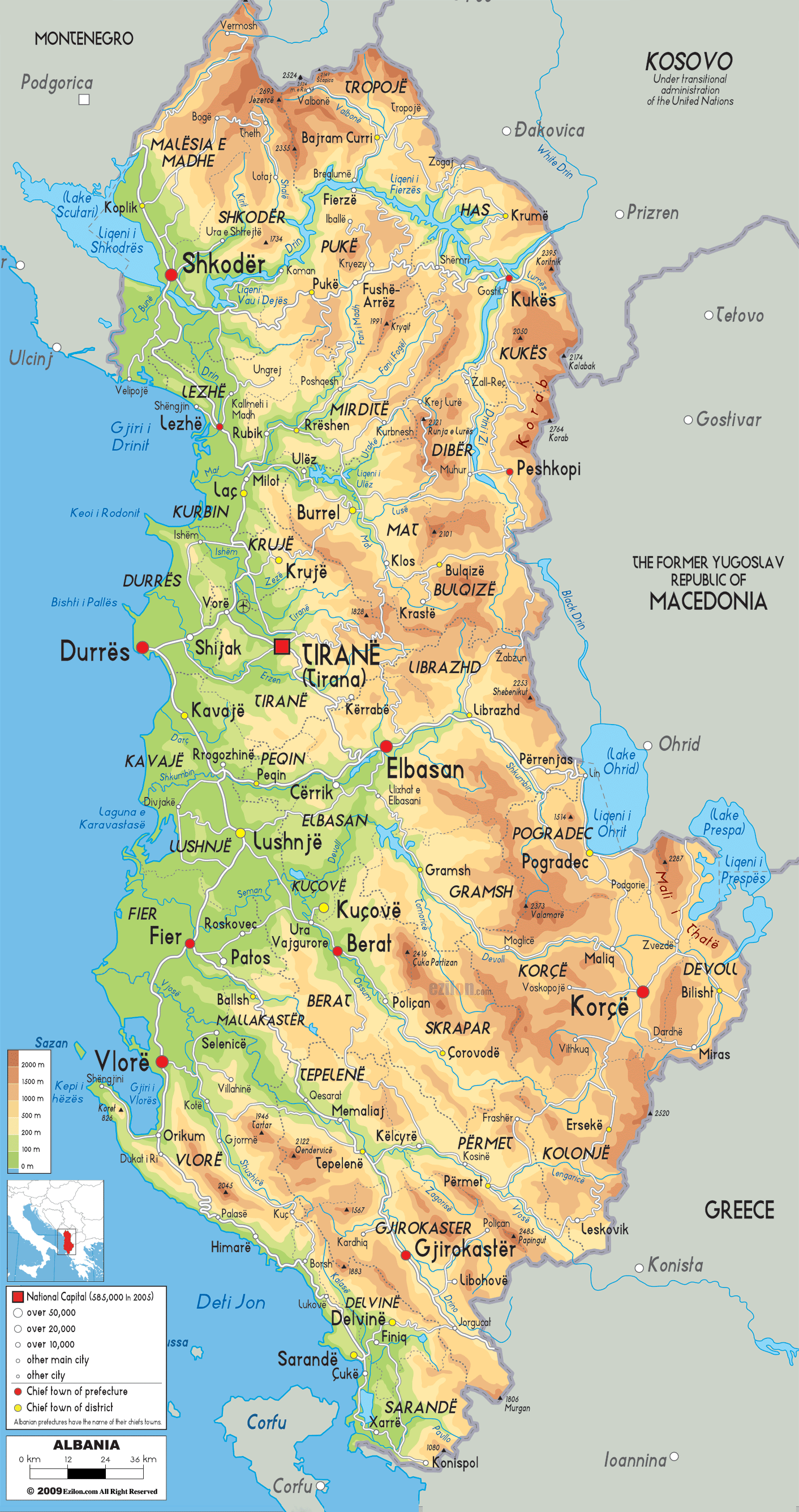
Description: The Physical Map of Albania showing geographical features like elevations, mountain ranges, seas, lakes, plateaus, peninsulas, rivers, plains, landforms and other topographic features.
 Looking at this stunning physical map of Albania, you're witnessing one of Europe's most diverse and dramatic landscapes compressed into a relatively small area. Whether you're a geography student studying topographical features, a traveler planning hiking adventures, or a local Albanian curious about your homeland's natural beauty, this comprehensive guide will help you understand every mountain, valley, river, and coastal plain that makes Albania truly spectacular.
A physical map is nature's autobiography written in colors and contours. Unlike political maps that show human-made boundaries, this Albania physical map reveals the country's natural skeleton - its mountains, valleys, rivers, and plains that have shaped Albanian culture, history, and daily life for thousands of years.
Looking at the color-coded elevation system on this map, you can immediately see how Albania transitions from the deep blue of the Adriatic Sea through the green coastal plains, up through the brown and orange mountain ranges that dominate the country's interior. Each color tells a story of altitude, climate, and the challenges and opportunities that geography presents.
Looking at the legend on this physical map, Albania's elevation ranges are clearly marked:
This elevation system reveals that Albania is fundamentally a mountainous country, with approximately 70% of its territory above 300 meters in elevation.
Looking at the northern region of this physical map, the darkest brown areas represent the Albanian Alps (Prokletije Mountains), some of the most spectacular peaks in the Balkans. These mountains, rising above 2000 meters, create a natural barrier between Albania and Montenegro.
For geography students: Notice how these mountains form a natural border - this is called orographic boundary formation, where mountain ranges create political boundaries.
For travelers: This northern mountain region offers some of Europe's best hiking, with peaks like Maja e Jezercës (2,694m) - though individual peaks aren't labeled on this map, you can see the concentration of the darkest brown coloring indicating these highest elevations.
For locals: These mountains are the source of many of Albania's rivers and represent the country's most pristine wilderness areas.
Looking at the northwestern section of this physical map, Lake Shkodër (Liqeni i Shkodrës) appears as a prominent blue feature shared with Montenegro. This is the largest lake in the Balkans, and on this map, you can see how it's surrounded by green lowlands, indicating the fertile plains that surround it.
The lake's position creates a unique microclimate that supports diverse ecosystems and has historically made this region one of Albania's most important agricultural areas.
Looking at the central portion of this physical map, you can observe how the mountains create a spine running north-south through the country. The varying shades of brown and orange show how this central region features medium to high elevations, creating a natural barrier between the coastal plains and the eastern highlands.
Around Tirana: Notice how the capital sits in a lighter brown area, indicating it's positioned in a valley or basin surrounded by hills - this is the Tirana Basin, a natural depression that has made it an ideal location for urban development.
Durrës Coastal Plain: Looking at the area around Durrës, the bright green coloring shows this is one of Albania's most significant lowland areas, perfect for agriculture and urban development.
Looking at the blue lines snaking through the central region, you can trace several important river systems:
These rivers have carved valleys (shown in lighter colors) through the mountainous terrain, creating natural corridors for transportation and settlement.
Looking at the eastern border region on this physical map, the predominant brown and orange coloring reveals a consistently mountainous landscape. This region, bordering North Macedonia and Kosovo, represents some of Albania's most rugged terrain.
For geography students: This eastern mountain system is part of the Dinaric Alps extension, demonstrating how mountain ranges can span multiple countries.
For travelers: This region offers incredible hiking opportunities but requires serious preparation due to the challenging terrain indicated by the dark brown coloring.
Looking at the southeastern corner of this physical map, two significant blue areas mark Lake Ohrid and Lake Prespa. These transboundary lakes are shared with North Macedonia and Greece, respectively.
Lake Ohrid: One of Europe's oldest and deepest lakes, visible on the map as a substantial blue area near Pogradec. The surrounding orange-brown coloring indicates the mountainous terrain that cradles this ancient lake.
Lake Prespa: Appearing as a smaller blue area further south, this lake system is shared between Albania, North Macedonia, and Greece, representing one of the Balkans' most important wetland ecosystems.
Looking at the southern portion of this physical map, the continued brown and orange coloring shows how Albania's mountainous character extends all the way to the Greek border. The Ceraunian Mountains (Mali i Vetëtimës) create the backbone of the southern region.
Around Gjirokastër: The map shows this historic city positioned in an orange-brown area, indicating it sits in the mountains at a considerable elevation, which explains its dramatic setting and stone architecture.
Korçë Plateau: Looking at the area around Korçë, you can see a lighter brown area surrounded by darker mountains, indicating this city sits on a high plateau - one of Albania's most important agricultural regions despite its elevation.
Looking at the southwestern coast on this physical map, notice how the brown mountain coloring comes almost directly to the blue sea. This creates the Albanian Riviera, where mountains plunge dramatically into the Ionian Sea.
For travelers: This topographical feature creates some of the most spectacular coastal scenery in the Mediterranean, with mountains rising directly from pristine beaches.
Around Sarandë: The map shows this resort town positioned where the mountains meet the sea, creating the perfect setting for tourism development.
Looking at the western edge of this physical map, the extensive green coloring along the Adriatic Sea reveals Albania's most important agricultural region. This coastal plain, extending from Shkodër in the north to Vlorë in the south, represents less than 30% of Albania's territory but supports much of its population.
For geography students: This is a classic example of an alluvial plain, formed by centuries of river sediment deposits from the mountain rivers flowing westward.
For locals: This green zone on the map represents Albania's breadbasket - the region that feeds the nation.
Looking at the red squares marking major cities on this physical map, you can understand why they developed where they did:
Looking at this physical map, you can predict Albania's climate zones based on elevation and proximity to the sea:
Green Coastal Areas: Mediterranean climate with mild winters and warm summers
Orange-Brown Hills: Transitional climate with cooler temperatures
Dark Brown Mountains: Continental mountain climate with cold winters and cool summers
Looking at the mountain orientations on this map, you can see how the western slopes (facing the sea) receive more precipitation than the eastern slopes, creating distinct ecological zones on either side of the mountain ranges.
Looking at the mountainous regions (brown and orange areas) on this physical map, these areas contain Albania's mineral wealth:
Looking at the river systems flowing from the mountains (dark brown) toward the sea (blue), you can see Albania's enormous hydroelectric potential. The steep gradients indicated by the rapid color changes from brown to green show ideal conditions for hydroelectric power generation.
Looking at this physical map, you can identify natural transportation corridors:
The extensive brown and orange coloring in the interior shows why Albania has historically been challenging to traverse and why many communities remained isolated until modern road building.
Looking at the color gradations on this physical map, each elevation zone supports different ecosystems:
Green Lowlands: Mediterranean vegetation, agricultural areas, wetlands
Light Brown Hills: Oak forests, mixed deciduous woodland
Orange-Brown Mountains: Coniferous forests, alpine meadows
Dark Brown High Mountains: Alpine vegetation, glacial lakes
The isolated mountain ranges (dark brown areas) on this map represent refugia where endemic species evolved during ice ages, making Albania a biodiversity hotspot.
Looking at the blue lines on this physical map, you can trace Albania's major watersheds:
Drin River System: The longest river, draining the northern and eastern mountains
Shkumbin River: Flowing from the central mountains to the Adriatic
Seman River: Draining the central-southern region
Vjosa River: One of Europe's last wild rivers, flowing through the southern mountains
The green areas on this map often indicate areas with good groundwater resources, while the brown mountain areas show regions where surface water is more important than groundwater.
Looking at the alignment of mountain ranges on this physical map, you can see evidence of the tectonic forces that created Albania's landscape. The north-south orientation of many mountain ranges reflects the collision between the African and Eurasian tectonic plates.
The lighter-colored valleys cutting through the darker mountain areas show how rivers have carved through the landscape over millions of years, creating the dramatic topography visible today.
Looking at the dark brown areas on this map, these represent Albania's most challenging but rewarding hiking destinations. The color intensity directly correlates with difficulty level and scenic beauty.
The green coastal areas meeting the blue sea show where you'll find Albania's beaches, while the brown areas coming directly to the coast indicate dramatic cliff coastlines.
Cities positioned in orange-brown areas (like Gjirokastër and Berat) typically have more traditional mountain architecture, while those in green areas have more Mediterranean influences.
Looking at this comprehensive physical map, Albania emerges as a land of incredible diversity compressed into a small area. From the snow-capped peaks of the Albanian Alps to the pristine beaches of the Riviera, from the ancient lakes of the southeast to the fertile plains of the west, every color on this map represents a different facet of Albania's natural heritage.
Whether you're studying geography, planning adventures, or simply appreciating the natural world, this physical map reveals why Albania truly deserves its nickname as "the Land of Eagles" - a country where dramatic landscapes soar as high as the eagles that nest in its mountain peaks.
The next time you look at this map, remember that each color, each line, and each elevation marker represents not just geography, but the foundation upon which Albanian culture, history, and daily life have been built for thousands of years.

Political Map of Albania
Physical map and map image of Albania.

Road Map of Albania
Road map and map image of Albania.

Regional Directory of United States of America
Information and guide about United States of America and websites with American topics.

Regional Directory of Europe
Information and guide about Europe and websites with European topics.

Regional Directory of Australia
Information and guide about Australia and websites with Australian topics.