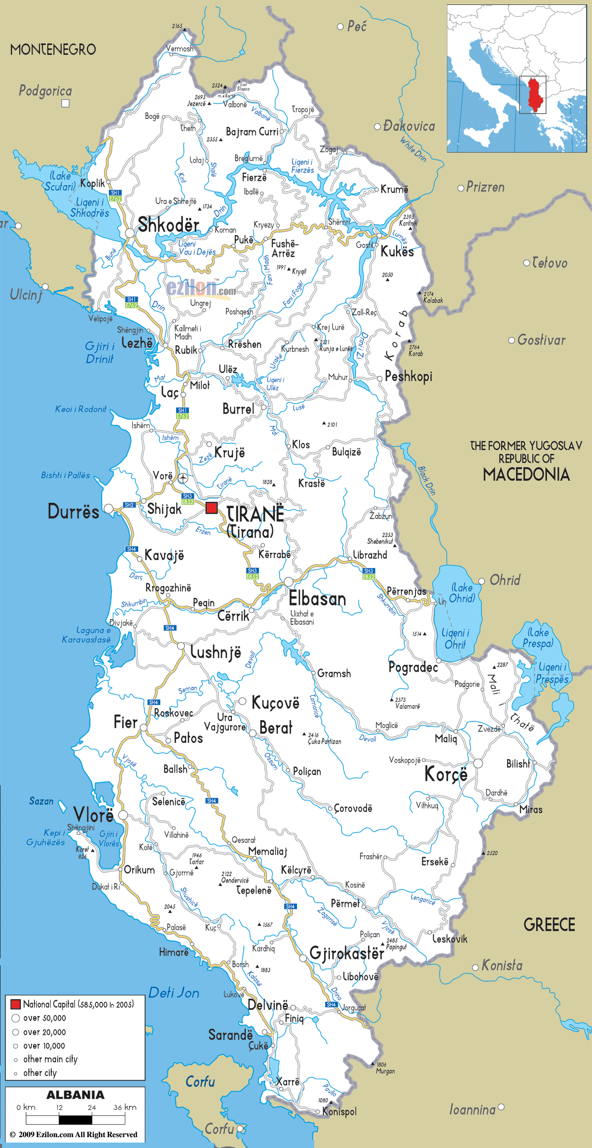
Description: Detailed clear large road map of Albania with roads from cities to towns, road intersections to regions, provinces, prefectures with routes leading to neighboring countries.

A road map is essentially the nervous system of a country laid bare – showing how people, goods, and ideas flow from one place to another. Looking at this Albania road map, you can see how geography has shaped transportation patterns, where modern highways follow ancient trade routes, and how a small mountainous country has managed to connect its scattered communities across challenging terrain.
The different line types and colors on this map tell stories of importance, capacity, and connectivity. Major highways appear as thick lines, secondary roads as thinner lines, and local roads as the finest lines that spider web across the landscape, reaching into every valley and mountain village.
Looking at the legend on this road map, Albania's road network follows a logical hierarchy:
The map's legend clearly shows population-based city classifications:
Looking at the western edge of this road map, the A1 highway represents Albania's most crucial transportation artery. This highway runs north-south along the coastal plain, connecting:
Northern Section: Starting from the Montenegro border near Shkodër, the A1 provides the main connection to Albania's lake region and northern mountains.
Central Section: Passing through Lezhë and connecting to Durrës, Albania's principal port city. Looking at the map, you can see how this section links the coast to Tirana via connecting roads.
Southern Section: Continuing south through Fier and extending toward Vlorë, this portion serves Albania's agricultural heartland and connects to the Albanian Riviera.
For travelers: The A1 is your gateway to Albania's beaches, coastal cities, and western plains – essentially the country's most developed tourist corridor.
For geography students: Notice how this highway follows the coastal plain, taking advantage of the flattest terrain for maximum efficiency.
Looking at the central portion of this road map, the A2 highway creates Albania's most important east-west connection, linking:
Durrës to Tirana: This section is arguably Albania's busiest road, connecting the main port to the capital city. The short distance between these cities (visible on the map) makes this a crucial economic corridor.
Tirana to Elbasan: Continuing eastward, the A2 provides access to central Albania's industrial and agricultural regions.
For locals: This is probably the road you know best if you live in central Albania – it's the backbone of daily commuting and commercial transport.
For travelers: The A2 gives you access to Albania's heartland and serves as a launching point for mountain adventures.
Looking at the northern section of this road map, the A3 highway connects:
Tirana to Shkodër: This highway provides the main link between the capital and Albania's northern regions, including access to the Albanian Alps.
Shkodër to Montenegro Border: The A3 extends to Hani i Hotit, providing the main international connection to Montenegro.
For adventure travelers: This highway is your route to Albania's most spectacular mountain scenery and hiking opportunities.
Looking at the northern portion of this road map, the road network becomes more challenging as it enters the Albanian Alps region:
Shkodër Hub: Notice how roads radiate out from Shkodër like spokes on a wheel, connecting to:
Mountain Challenges: The roads in this region, visible as thinner lines on the map, wind through challenging terrain to reach isolated communities like Theth and Valbonë (though these specific villages aren't labeled on this map scale).
For geography students: Notice how road density decreases as elevation increases – a perfect example of how topography influences infrastructure development.
Looking at the central region of this road map, you can see how Tirana functions as the hub of Albania's road network:
Tirana's Radiating Roads: From the capital, major roads extend in all directions:
Secondary Cities as Regional Hubs:
Looking at the southern portion of this road map, you can observe how the network adapts to both coastal and mountainous terrain:
Coastal Route: The road following the coastline from Vlorë to Sarandë serves the Albanian Riviera, though it appears as a secondary road rather than a major highway.
Mountain Connections: Roads connecting inland cities like:
Border Crossings: Multiple roads extend to Greek border crossings, including routes from Gjirokastër, Korçë, and coastal areas.
Looking at the northern border on this road map, several crossing points connect Albania to Montenegro:
Hani i Hotit: The main crossing, accessible via the A3 highway from Shkodër
Muriqan: Another crossing point serving the lake region
Vermosh: Mountain crossing in the Albanian Alps region
Looking at the northeastern border on this road map, connections to Kosovo include:
Krumë: Major crossing point accessible from Shkodër
Morinë: Another significant crossing in the northeastern mountains
Prush: Additional crossing serving the border region
Looking at the eastern border on this road map, several routes connect to North Macedonia:
Qafë Thanë: Major crossing near Struga, accessible from Pogradec
Goricë: Crossing serving the southeastern region
Tushemisht: Another crossing point near the lake region
Looking at the southern border on this road map, multiple crossings serve the Greek frontier:
Kakavijë: Major crossing accessible from Gjirokastër
Kapshticë: Important crossing serving the Korçë region
Qafë Botë: Crossing serving the southern coastal area
Looking at the western coastline on this road map, the coastal road system serves Albania's Adriatic beaches:
Shkodër to Durrës: Following the A1 highway through the coastal plain
Durrës to Vlorë: Continuing south along the coast, serving major beach destinations
For beach travelers: This route connects all of Albania's major coastal cities and beach resorts along the Adriatic Sea.
Looking at the southwestern coast on this road map, the road from Vlorë to Sarandë serves the famous Albanian Riviera:
Vlorë to Orikum: Beginning of the riviera route
Orikum to Himarë: Winding coastal road through dramatic scenery
Himarë to Sarandë: Continuing along the Ionian Sea coast
For travelers: This is one of Europe's most spectacular coastal drives, though the map shows it as a secondary road, indicating it may be more challenging than major highways.
Looking at the northern mountains on this road map, several roads provide access to Albania's most dramatic landscapes:
Shkodër to Theth: Though the specific road to Theth isn't clearly marked on this map scale, roads from Shkodër provide access to the Albanian Alps region.
Valbonë Valley Access: Roads from Bajram Curri serve the Valbonë National Park area.
For adventure travelers: These mountain roads often require 4WD vehicles and are seasonal, but they provide access to some of Europe's most pristine wilderness.
Looking at the central mountainous region on this road map, several roads cross the challenging terrain:
Tirana to Korçë: A mountain road crossing central Albania's highlands
Elbasan to Ohrid: Route serving the southeastern lake region
Berat to Korçë: Mountain road connecting UNESCO cities
For geography students: These mountain crossings show how road builders have used natural passes and river valleys to cross challenging terrain.
Looking at the southern mountains on this road map, roads serve historic mountain cities:
Gjirokastër Access: Roads from multiple directions serve this UNESCO World Heritage city
Përmet Route: Road through the Vjosa River valley
Tepelenë Connections: Roads serving the southern mountain region
Looking at the capital city on this road map, Tirana functions as the center of Albania's road network:
Ring Road System: Though not clearly marked on this map scale, Tirana has developed ring roads to manage traffic flow
Radiating Highways: All major highways either originate from or pass through the Tirana metropolitan area
Airport Access: Roads connecting to Tirana International Airport (Mother Teresa Airport)
For locals: Understanding Tirana's road network is crucial for navigating Albania's transportation system.
Looking at Shkodër on this road map, it serves as the gateway to northern Albania:
Lake Access: Roads serving Lake Shkodër region
Mountain Access: Routes to Albanian Alps
International Connections: Roads to Montenegro and Kosovo borders
Looking at Durrës on this road map, its strategic position is clear:
Port Access: Roads serving Albania's main port facility
Highway Connections: Junction of A1 and A2 highways
Economic Corridor: Key link in Albania's import/export infrastructure
Looking at the mountain roads on this road map, many routes face seasonal challenges:
High Mountain Roads: Often closed or require special equipment during winter months
Coastal Roads: Generally accessible year-round
Main Highways: Maintained for year-round travel
Looking at the coastal routes on this road map, summer brings increased traffic:
Beach Access Roads: Heavy traffic during tourist season
Mountain Access: Peak hiking season increases mountain road usage
International Borders: Increased traffic from international tourists
Looking at the major highways on this road map, you can trace Albania's economic lifelines:
Port to Capital: A2 highway carries goods from Durrës port to Tirana
Agricultural Transport: Roads serving the coastal plain transport agricultural products
Cross-Border Trade: International connections facilitate regional commerce
Looking at the road connections on this road map, tourism depends heavily on road access:
Coastal Tourism: A1 highway and coastal roads serve beach destinations
Cultural Tourism: Roads connecting UNESCO sites like Berat and Gjirokastër
Adventure Tourism: Mountain roads provide access to hiking and outdoor activities
Looking at current road infrastructure on this map, several expansion projects are improving connectivity:
Highway Completion: Ongoing projects to complete the highway network
Border Improvements: Upgrading border crossing facilities
Mountain Access: Improving roads to remote mountain communities
Looking at the road network's relationship to natural features on this map:
Protected Areas: Balancing road access with environmental protection
Sustainable Tourism: Managing road development to support tourism without damaging natural attractions
Climate Adaptation: Designing roads to withstand extreme weather events
Looking at the road network on this map, successful travel requires understanding:
Highway vs. Secondary Roads: Major highways offer speed and reliability, while secondary roads provide scenic routes
Mountain Road Conditions: Always check conditions before attempting mountain routes
Border Crossing Requirements: Ensure proper documentation for international travel
Looking at the city distribution on this road map:
Service Intervals: Major cities provide full services, while mountain areas may have limited facilities
Fuel Planning: Ensure adequate fuel when traveling through remote areas
Emergency Services: Understand that mountain areas may have limited emergency access
For international travelers: Albanian driving customs may differ from your home country
Mountain Driving: Special skills required for narrow, winding mountain roads
Urban Navigation: City centers may have pedestrian zones and parking restrictions
Looking at the road patterns on this map, many follow ancient paths:
Roman Routes: Some roads follow ancient Roman transportation corridors
Ottoman Paths: Historical connections between regional centers
Traditional Trade Routes: Mountain passes used for centuries
Looking at the highway system on this map, Albania's road network represents:
Post-Communist Development: Major infrastructure improvements since 1990
European Integration: Roads connecting Albania to European transportation networks
Economic Development: Infrastructure supporting Albania's economic growth
A detailed road map of the country provides insightful knowledge to unlock any nation’s mystery. No matter if you are going to the Adriatic coast, the Albanian Alps, a tour of UNESCO cities, or the complete country circuit, this road network is your gateway to all that and much more.
This map shows how each line connects points or communities. Also, the links between places have formed the life of the Albanian people for generations or years. Albania is replete with road networks that are functional and aesthetically appealing. Whether it is the modern highways which cater to the needs of commerce and tourism or the mountain roads which ensure connectivity to traditional communities. This will attest to the road network of Albania. The ornamental flower designs along the roads further contribute to the intrinsic beauty of the nation.
For geography students: The map shows how elevation affects the development of infrastructure and how transport networks influence economic and social processes.
These roads will lead you to visit one of Europe’s most beautiful and diverse countries, offering below pristine beaches, ancient cities and unspoiled mountain wilderness.
For the locals, it is the network that links the Albanian community together for basic trading, visiting family, and cultural exchange.
Albania Road Map - Whether you are driving a car or bus, or studying the transport geography of Albania, this road map illustrates quite a small, and yet, very diverse country. A country where you can meet the Mediterranean beach and the Alpine peak in just a few hours of driving time. A journey into a modern city, medieval town, busy highway or quiet mountain valley only takes as little as a few hours – an impressive feat for any country!
Albania’s roads weave a tapestry of life in Albania. The ancient to modern; the mountain to the sea; the tradition to the contemporary – all come together harmoniously. No wonder Albania is known as the Land of Eagles. The roads in Albania lead there!

Political Map of Albania
Physical map and map image of Albania.

Physical Map of Albania
Physical map and map image of Albania.

Regional Directory of United States of America
Information and guide about United States of America and websites with American topics.

Regional Directory of Europe
Information and guide about Europe and websites with European topics.

Regional Directory of Australia
Information and guide about Australia and websites with Australian topics.