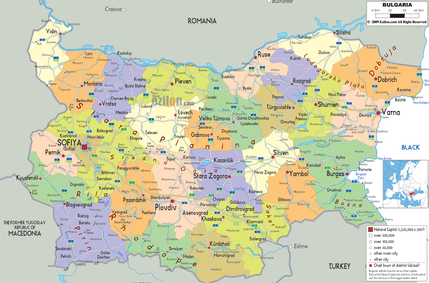
Description: Detailed large map of Bulgaria showing names of capital cities, towns, states, provinces and boundaries with neighbouring countries.

The map of Bulgaria, including major cities and the road network, is the primary focus of this guide. Our detailed map presents the political layout of Bulgaria in a single view, outlining every province, highlighting the provincial capitals, and tracing the key national roads linking Sofia, Plovdiv, Varna, Burgas, and dozens of other towns. This explanation is written so that readers, travelers, and geography students can follow the map of Bulgaria step by step and understand how the country is organised.
Bulgaria sits in the eastern part of the Balkans. On our political map of Bulgaria, you can clearly see the neighboring states that frame it: Romania to the north, Serbia and North Macedonia to the west, Greece and Turkey to the south, and the Black Sea to the east. These borders form the outer frame of the Bulgaria map, show cities, and help users quickly see how Bulgarian provinces line up with foreign regions and key crossings.
The colorful provincial blocks on the map represent Bulgaria's 28 districts (oblasts). Within each oblast, main cities are marked with larger symbols, while smaller towns appear as finer dots. Red squares mark the national capital and the seats of the oblasts, and the clean road network connecting them makes it easy to see how administration and transport fit together.
At the western centre of the map stands SOFIYA (Sofia), marked by a large red square indicating it as the national capital. The surrounding area is split into two critical administrative units:
Sofia City - a separate capital district, focused on the urban core.
Sofia Province (Sofiyska oblast) – surrounding municipalities such as Pernik, Kostinbrod, Samokov, and Botevgrad, which appear around the city on the map.
These two units are shaded differently, so residents and visitors can immediately see when they move from the city district into the wider province.
On the rest of the detailed map of Bulgaria, each province is labelled with its name and has a marked district (oblast) chief town. For example:
Vidin in the far north west.
Plovdiv is in the south-central region.
Varna is on the central Black Sea coast.
Burgas is in the southeast on the coast.
Ruse on the Danube border with Romania.
Stara Zagora, Haskovo, Smolyan, Kardzhali, Blagoevgrad, and many more.
A small legend in the lower right corner explains the symbols used: circles graded by population size, red squares for the national capital and chief towns, and outlines for the district boundaries.
In this section, we walk across the Bulgaria map, following the eye as it travels over the printed sheet, focusing on provinces, capitals, and the road network that links them.
Starting in the upper-left corner, the Vidin Province borders both Romania and Serbia. The city of Vidin sits on the Danube, on the border with Romania, and is clearly connected by roads to Lom and to Montana further inland. The political map makes it clear that Vidin province is a key northern border region.
Moving eastwards, Montana province is centred on the town of Montana, with other towns such as Lom, Berkovitsa, and Varshets marked. Road links pass through mountain passes toward Sofia Province in the south and Vratsa in the east.
The next province, Vratsa, places the city of Vratsa close to the northern slopes of the Balkans, with significant connections to Mezdra, Botevgrad, and Pleven. From here, the network continues into Pleven province, where the city of Pleven acts as an important regional hub. Surrounding towns like Knezha, Cherven Bryag, and Levski are shown on the map, highlighting the dense settlement pattern along the long north Bulgarian corridor.
As the eye moves slightly south, Lovech province lies between Pleven and the central mountains, with Lovech (Loven) as the capital, from Lovech, roads on the detailed map of Bulgaria link northwards to Pleven and southwards across the country toward Troyan and the central ridge.
Further east, you reach Veliko Tarnovo province. The city of Veliko Tarnovo is clearly marked along the Yantra valley and acts as a political and historical centre. Nearby towns Gorna Oryakhovitsa, Lyaskovets, Pavlikeni, and Svishtov are all visible, and key roads link the province with Ruse to the north and Stara Zagora to the south.
Gabrovo is a minor but crucial central province. On the map, the town of Gabrovo sits almost in the middle of the country, with roads converging from Sevlievo, Dryanovo, and Tryavna. Its location shows how Gabrovo acts as a bridge between northern and southern Bulgaria.
On the Danube River to the north, Ruse province occupies a strategic corner. Ruse city is highlighted as a significant port and crossing point toward Romania, and the map shows roads leading from Ruse toward Razgrad, Shumen, Veliko Tarnovo, and Silistra.
In the north-east, our Bulgaria map with cities shows a cluster of provinces that fan out from the Danube and the Black Sea.
Razgrad province has Razgrad as its capital, with roads linking to Ruse, Targovishte, and Shumen.
Targovishte province centres on Targovishte, with towns such as Omurtag and Popovo around it.
Shumen province, marked by the city of Shumen, stretches from the plateau near the Danube to the east-west highway that connects Sofia to Varna.
Silistra lies in the far north-east on the Danube border, with Silistra town linked by road to Dobrich and Ruse.
Closer to the coast, Dobrich province lies inland from the Black Sea. The city of Dobrich is visible as the administrative capital, while the map also names smaller towns such as Balchik and General Toshevo.
On the coast itself lies Varna Province, one of the most critical regions on Bulgaria's political map. The city of Varna is marked as a significant urban centre and seaport. Roads from Varna run north toward Balchik, south toward Byala and Burgas, and west toward Shumen and Ruse, forming a strong intersection between inland Bulgaria and the Black Sea shore.
Moving down the eastern side of the Bulgaria map with cities, we come to Burgas province. The city of Burgas is highlighted on the southern Black Sea coast, with connecting roads to Pomorie, Aytos, Karnobat, and Sozopol. Because the map is political rather than physical, the emphasis is on how Burgas coordinates a network of coastal and inland towns within its district boundaries.
Inland from Burgas lies Sliven province, with the town of Sliven clearly labelled. Roads link Sliven to Yambol, Nova Zagora, and Stara Zagora, making it an essential inland junction.
South of Sliven, Yambol province is centred on Yambol town. The map shows connecting routes from Yambol to Elhovo, near the border with Turkey, and northward toward Sliven and Nova Zagora. Together, Burgas, Sliven, and Yambol form the core of southeast Bulgaria and stand close to the borders with Turkey and Greece, which are indicated along the lower edge of the map.
The central band of southern Bulgaria is densely labelled on our detailed map.
Stara Zagora Province is named after its capital, Stara Zagora, with towns such as Kazanlak, Chirpan, and Radnevo surrounding it. The road network extends east toward Nova Zagora, west toward Plovdiv, and south toward Dimitrovgrad and Haskovo.
The large Plovdiv province is one of the most populated areas. Plovdiv city sits near the centre, linked by major highways to Sofia, Stara Zagora, Pazardzhik, and Haskovo. Other towns such as Asenovgrad, Karlovo, Sopot, and Parvomay underscore the region's political activity.
Kardzhali province lies south of Plovdiv and Haskovo. The capital, Kardzhali, is connected by roads to Momchilgrad, Dzhebel, and Krumovgrad, and the provincial boundary touches both Greece and Turkey.
Haskovo province centres on Haskovo town, with Dimitrovgrad, Svilengrad, and Harmanli shown as key hubs. Svilengrad, near the Turkish and Greek borders, appears as a central crossing point on the political map.
Further west, Smolyan province stretches along the southern border. The town of Smolyan is marked by roads to Devin, Chepelare, and Rudozem, demonstrating how this district connects to Kardzhali and Plovdiv.
In the southwest corner, the detailed map of Bulgaria highlights several provinces that touch North Macedonia and Greece.
Blagoevgrad province is centred on Blagoevgrad town, with notable places like Bansko, Razlog, Petrich, Sandanski, and Gotse Delchev clearly labelled. Roads connect these towns to the north, toward Sofia, and to the east, toward Smolyan and Kardzhali. The border with Greece and North Macedonia is drawn just below, showing how the province links Bulgaria with both neighbours.
Kyustendil province lies to the north of Blagoevgrad, with Kyustendil as the capital. From here, roads lead toward Dupnitsa, Bobov Dol, and the Serbian border.
Pernik province sits closer to the capital, with Pernik town acting as an industrial and commuter centre west of Sofia.
Finally, Sofia Province surrounds the special Sofia City district. Towns such as Botevgrad, Samokov, Ihtiman, Elin Pelin, and Kostinbrod form a ring of settlements, all carefully plotted on the map.
Between Sofia and Plovdiv lies Pazardzhik province. The town of Pazardzhik is a visible stop on the main highway, with nearby cities Velingrad, Peshtera, and Septemvri also shown. This area helps users see how the main east-west corridor across southern Bulgaria operates politically, running from Sofia through Pazardzhik to Plovdiv and Stara Zagora.
The central position of the provinces of Lovech, Gabrovo, and Veliko Tarnovo, as described earlier, gives a sense of how north-south corridors run through the middle of the country, connecting the Danube border with the southern frontier.
The top of the map follows the long line of the Romanian border. Cities such as Vidin, Lom, Kozloduy, Ruse, and Silistra lie along this edge and are connected by roads that parallel the boundary. Romanian towns across the border, including Craiova and Bucharest, are labelled to provide a cross-border context.
On the left side of the image, two countries are shown. Both of these have a border with Bulgaria. One is Serbia, and the other is North Macedonia. Towns such as Kyustendil, Tran, and Belogradchik are close to Serbia. Blagoevgrad, Petrich, and Sandanski are near North Macedonia and Greece. Residents and travelers use border lines to determine where areas meet and where crossing points are.
The southern edge of the Bulgaria map, marked by cities, marks the boundaries with Greece and Turkey. Provinces Smolyan, Kardzhali, Haskovo, Yambol, and Burgas touch these frontiers. Towns such as Svilengrad and Malko Tarnovo are clearly placed near the border, indicating important road links for international travel and trade.
On the right, the map outlines the Black Sea coast and emphasises the coastal districts of Varna and Burgas. Cities like Varna, Burgas, Balchik, and Sozopol show where administrative centres meet ports and seaside resorts. While physical features are not the focus here, the shoreline provides a clear political frame for eastern Bulgaria.
Residents can use this map of Bulgaria to locate their exact municipality within its province, find the nearest chief town, and note how regional roads connect to Sofia or to border crossings. Because each district is colour-coded and labelled, it is easy for citizens to understand which oblast they live in and which neighbouring provinces lie next door.
Travelers can use the Constituency Map for city and area planning during road journeys. Users who follow the clean route network, which connects the major towns, can sketch routes like Sofia - Varna, Sofia - Burgas, or Plovdiv to Ruse, which also indicates which provincial capitals and border towns we will pass through.
The Bulgarian Administrative Map will help geography students and researchers. The map will show Bulgaria's administrative system. Splitting Bulgaria into 28 parts, each with a district capital and a national border, is ideal for assignments, presentations, and comparative political geography.

Physical Map of Bulgaria
Physical map and map image of Bulgaria.

Road Map of Bulgaria
Road map and map image of Bulgaria.

Regional Directory of United States of America
Information and guide about United States of America and websites with American topics.

Regional Directory of Europe
Information and guide about Europe and websites with European topics.

Regional Directory of Australia
Information and guide about Australia and websites with Australian topics.