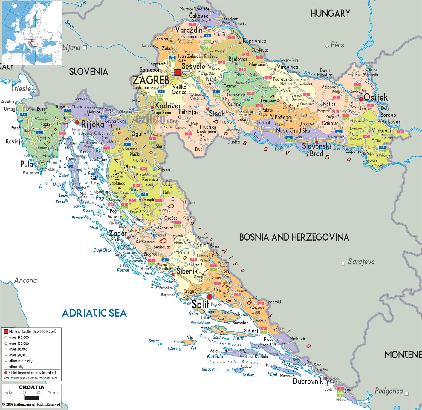
Description: Detailed large political map of Croatia showing names of capital cities, towns, states, provinces and boundaries with neighbouring countries.

This detailed guide focuses on a map of Croatia, with cities, major cities, and the road network. On this political map of Croatia, you can follow every county, coastal town, and inland route in a single clear view that works equally well for residents, travelers, and geography students.
Croatia lies in Southeast Europe, shaped like a long arch that curves around Bosnia and Herzegovina and stretches along the Adriatic Coast. Our detailed map shows how the country borders Slovenia to the northwest, Hungary to the north, Serbia to the east, Bosnia and Herzegovina across the interior, and Montenegro at the southern tip, while facing Italy across the Adriatic. This political map of Croatia highlights those boundaries so you can instantly see how each Croatian county aligns with neighbouring countries and key crossings.
The country is divided into 20 counties (županije) and the City of Zagreb, a separate county-level unit. The map of Croatia shows the counties, colour-coded, with the county name inscribed across the county and the county seat marked with a symbol. The map uses large circles or dots to show Croatia's major cities – Zagreb, Split, Rijeka, Osijek, Zadar, Šibenik, and Dubrovnik. Smaller circles show other towns important to regional life.
Main roads are drawn as clean lines that connect county seats and coastal centres. Even though the map does not label every road category, the pattern of routes between Zagreb, Rijeka, Split, Zadar, Osijek, and Dubrovnik makes the national network easy to understand at a glance.
At the northern heart of the map stands ZAGREB, the national capital and a separate county-level city. It lies close to the border with Slovenia. It sits at the meeting point of routes from Varazdin and ČakovecČakovec in the north, Karlovac and Rijeka in the west, Sisak in the southeast, and Bjelovar in the east.
The City of Zagreb is surrounded by Zagrebačka County, which includes towns such as Velika Gorica, Zaprešić, Samobor, Dugo Selo, and Ivanić-Grad. On the map, Zagreb's urban area is highlighted with a large red square and denser road lines, while the surrounding county towns are connected by more minor but clearly visible roads that feed into the capital.
The pink circle indicates the national capital. The country's population and the national capital are contained within the pink circle. The other pink circles provide information about cities with populations over 100,000. Tertiary towns, those with populations over 40000, are indicated with the yellow square. Cities with fewer than 40000 inhabitants are indicated with blue and black squares. A special mark shows the chief town of a county. Users can find the administrative centre of each county.
This political map of Croatia focuses on boundaries, counties, municipalities, major cities, and road links. It does not emphasise relief or other physical features, which keeps attention on how people, administration, and transport are organised.
Located far north, close to Slovenia and Hungary, the map shows quite a few small counties:
Krapinsko-Zagorska County, with the seat Krapina and towns like Zabok and Pregrada, spreads along the border with Slovenia.
Varaždinska County is centred on Varaždin, linked by road to Ivanec, Ludbreg, Novi Marof, and south toward Zagreb.
Međimurska County is in the extreme north between two rivers, with ČakovecČakovec as the county seat and nearby towns like Prelog and Mursko Središće.
Along the Drava corridor, Koprivnicko-Krizevacka County highlights Koprivnica and Križevci, while Bjelovarsko-Bilogorska County shows Bjelovar as a central hub.
On the Croatia map with cities, these northern counties are connected by east-west roads that follow the inland corridor between Zagreb and Osijek. Smaller routes run south into central Croatia and north to border crossings with Hungary.
A little to the south and west of the country capital, Zagreb, Karlovačka County appears on the map. Its central city, Karlovac, is not particularly interesting beyond being an administrative center. Karlovac has been depicted as the main junction where the road from Zagreb splits. The two branches go: one toward Rijeka along the coast, and the other toward Split farther south. Places like Ogulin, Slunj, and Duga Resa appear along the routes, which show how central Croatia connects the capital and the Adriatic.
To the southeast lies Sisačko-Moslavačka County, whose seat, Sisak, is visible at the junction of roads from Zagreb and Nova Gradiška. Other towns, such as Kutina, Petrinja, and Novska, are clearly marked, giving users a sense of the region's industrial and agricultural character.
Further, Ličko-Senjska County stretches from the interior to the coast. Gospić is its capital, positioned inland, while the map also marks coastal towns such as Senj and Karlobag. This county connects the central plateau with the Adriatic coast and is crossed by critical north-south routes between Zagreb and Dalmatia.
At the northwest corner of the Adriatic section, the political map of Croatia shows Istarska County, occupying the Istrian peninsula. The county seat, Pula, appears on the southern tip, with towns such as Rovinj, Poreč, Umag, Pazin, and Labin spread across the peninsula. This part of the Croatia map with cities makes it easy to see how roads circle the coastline and cross the interior between these towns.
East of Istria, around the Kvarner Gulf, lies Primorsko-Goranska County, with the major port city of Rijeka as its capital. Rijeka is marked by a prominent symbol and by dense road connections to Opatija, Crikvenica, and Delnice, as well as ferry routes to the islands of Krk, Cres, Rab, and Lošinj, whose main towns are also labeled. The county's position illustrates how Croatia's coastal network joins the islands with the mainland.
Running down the Adriatic, our detailed map of Croatia divides Dalmatia into several counties:
Zadar County, with Zadar as its seat. The map shows surrounding towns such as Benkovac, Biograd na Moru, Pag, and Nin, as well as island settlements on Dugi Otok and Ugljan.
Šibensko-Kninska County, centred on Šibenik, includes inland towns such as Knin and Drniš, as well as coastal towns such as Vodice and Primošten.
Splitsko-Dalmatinska County highlights Split as a major coastal metropolis. Towns such as Trogir, Omiš, Makarska, Sinj, and Imotski appear connected by a mesh of coastal and inland roads. Islands including Brač, Hvar, Vis, and orčula show their key settlements, underlining Split's role in regional transport.
At the southern end lies Dubrovačko-Neretvanska County, with Dubrovnik as the county seat. The map extends along the narrow coastal strip past Metković, Ploče, Opuzen, and Cavtat, and marks the border crossings with Bosnia and Herzegovina and Montenegro.
This part of the Croatia map with cities is essential for tourism and maritime connections, and the political view helps travellers understand which county and town they are looking at when they pick a resort or port.
Turning to the eastern arm of the country, the map presents Slavonia as a collection of counties that stretch along the Sava and Drava corridors:
Virovitičko-Podravska County, with Virovitica as its capital, is linked to towns such as Slatina and Orahovica.
Požeško-Slavonska County is centred on Požega, with towns such as Pakrac and Pleternica.
Brodsko-Posavska County, where Slavonski Brod serves as the county seat on the Sava corridor, with Nova Gradiška as another key town.
Osječko-Baranjska County, one of the largest eastern counties, includes the city of Osijek and the towns of Đakovo, Valpovo, Našice, and Beli Manastir.
Vukovarsko-Srijemska County in the far east, with Vukovar and Vinkovci clearly labelled, plus Županja near the border.
The political map underlines how these Slavonian counties line up along the borders with Hungary and Serbia. Roads link Osijek to Zagreb via Varaždin and Bjelovar, and to Vinkovci and Vukovar near the Danube.
Along the top left of the map, Croatia borders Slovenia. Cities like Zagreb, Karlovac, and Rijeka sit relatively close to this line, and smaller border towns such as ČakovecČakovec, Varaždin, and Krapina connect to Slovenian centres like Maribor and Ljubljana, shown in the inset.
To the north-east, the boundary with Hungary follows the upper part of Slavonia, with Croatian towns Čakovec, Varaždin, Koprivnica, and Virovitica lying close by. The map shows roads that enable cross-border trade and travel between Croatian counties and Hungarian regions.
The eastern arm of Croatia touches Serbia along the Danube and Sava. Vukovar, Vinkovci, Ilok, and Tovarnik are shown near this frontier, and roads run through Osijek-Baranja and Vukovar-Srijem Counties toward Serbian cities such as Novi Sad and Belgrade beyond the border.
The long inner border with Bosnia and Herzegovina curves from north to south through central Croatia and along much of the Dalmatian hinterland. Towns such as Slavonski Brod, Sisak, Karlovac, Knin, and Metković lie along this line, and the map shows which Croatian counties border Bosnia and Herzegovina.
In the far southeast, Dubrovačko-Neretvanska Cou ty borders Montenegro. The map shows Dubrovnik and Cavtat close to this frontier, with a road leading down to the border crossing toward Herceg Novi and Kotor in Montenegro. Throughout the coastal strip, the Adriatic Sea forms Croatia's maritime boundary, while the political map continues to emphasise cities, counties, and routes rather than physical features.
Residents can use this political map of Croatia to locate their municipality, determine which county they belong to, and identify the nearest county seat. Because every county, from Međimurje to Dubrovnik-Neretva, is coloured and labelled separately, it is straightforward to see local government boundaries and how they relate to surrounding counties.
Those who want to travel can follow the roads. For example, you follow the route from Zagreb to Split, Rijeka to Dubrovnik, Osijek to Zadar, and note down the counties that you passed through along with the towns that were passed along the route. Coastal visitors can see precisely where resort towns like Poreč, Rovinj, Zadar, Šibenik, Makarska, and Dubrovnik sit in relation to the nearest county seat and border crossing
Geography students and researchers benefit from the clear administrative structure displayed on the map of Croatia. The division into county-level units, the position of county seats, and the portrayal of borders with neighbouring states all support studies of regional geography, political organisation, and demographic patterns.

Physical Map of Croatia
Physical map and map image of Croatia.

Road Map of Croatia
Road map and map image of Croatia.

Regional Directory of United States of America
Information and guide about United States of America and websites with American topics.

Regional Directory of Europe
Information and guide about Europe and websites with European topics.

Regional Directory of Australia
Information and guide about Australia and websites with Australian topics.