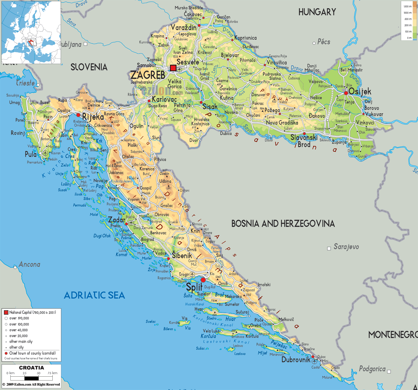
Description: The physical map of Croatia showing major geographical features like elevations, mountain ranges, seas, lakes, plateaus, peninsulas, rivers, plains, landforms and other topographic features.
This map of Croatia with mountains, hills, lakes, rivers and other terrains is already large enough to read directly on your desktop. To see a full-screen zoom view on a phone or tablet, tap the map image (or tap the Zoom Map label above the image). Scan by shading counties in various colored blocks, with Croatia's mountains, hills, lakes and rivers in bold.
 Croatia
is a country located in the meeting point of southeast
and central Europe. It is a part of the Balkan and
Mitteleuropa region. The country stretches across 56594
square kilometers of land area.
Croatia
is a country located in the meeting point of southeast
and central Europe. It is a part of the Balkan and
Mitteleuropa region. The country stretches across 56594
square kilometers of land area.
It lies between north latitudes 42 and 47 degrees and east longitudes 13 and 20 degrees. The country shares its borders with Bosnia and Herzegovina and Serbia towards the east, Slovenia to the west, Hungary to the North and Montenegro and the Adriatic Sea to the south.
The country is separated into 3 major
geomorphological parts known as the Dinaric Alps, the
Pannonian Basin and the Adriatic Basin. The Pannonian
Basin is dominated by low lying lands and makes up for
53% of the country’s land area.
The Dinaric Alps are the region of the high lands and
also contain the highest peak in the form of Dinara
which stands at 1831 meters.
The Adriatic Basin has a coastline as long as 1777
kilometers.
The Black Sea Drainage Basin drains the country’s
largest rivers like the Sava, Danube, Drava and Mur.
Whereas the Adriatic Drainage Basin drains the largest
river of all, known as the Neretva. The longest river in
the country is the Sava which flows for 562 kilometers.

Political Map of Croatia
Political map and map image of Croatia.

Road Map of Croatia
Road map and map image of Croatia.

Regional Directory of United States of America
Information and guide about United States of America and websites with American topics.

Regional Directory of Europe
Information and guide about Europe and websites with European topics.

Regional Directory of Australia
Information and guide about Australia and websites with Australian topics.