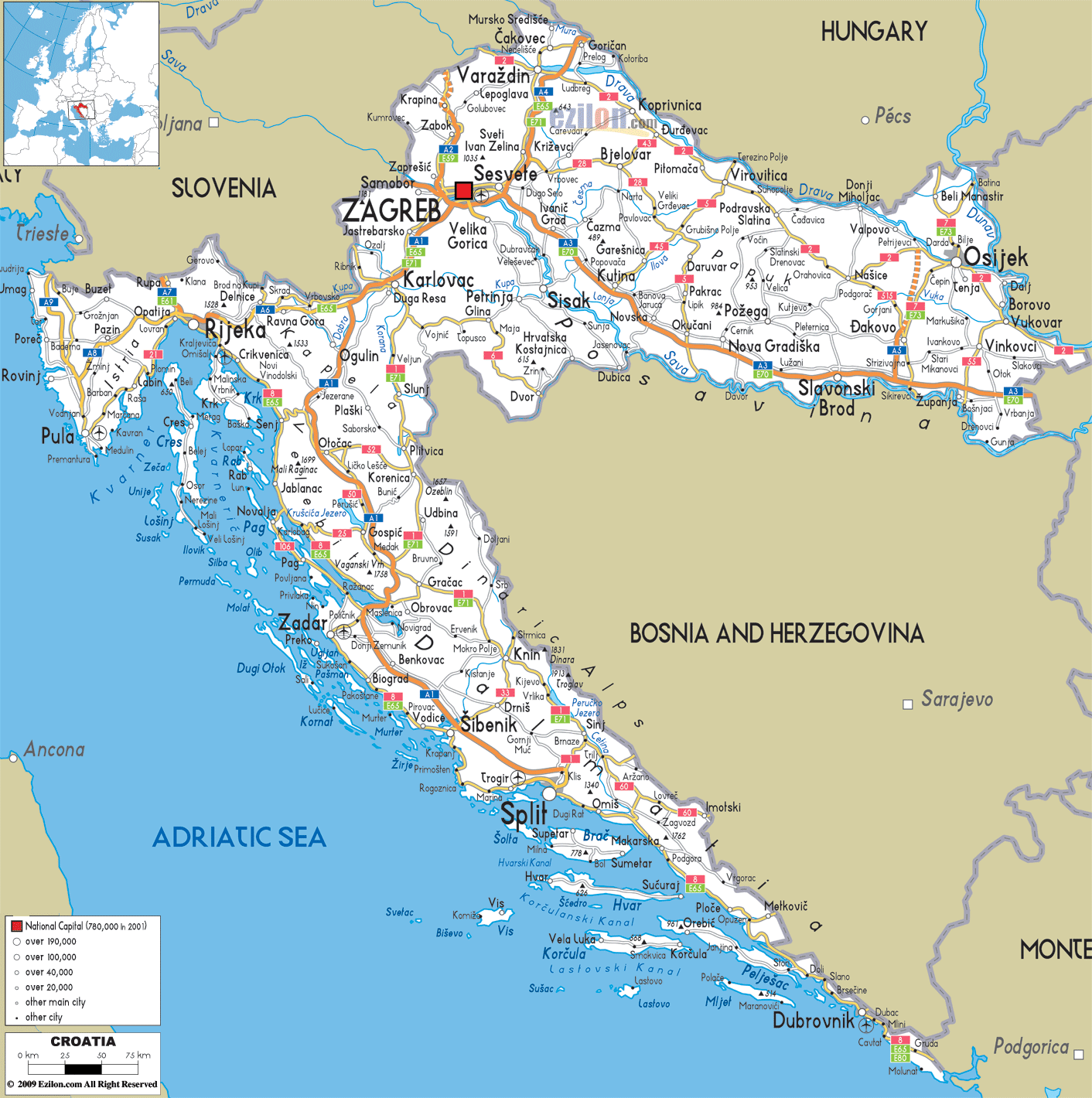
Description: Detailed clear large road map of Croatia with road access routes from cities to towns, road intersections in regions, provinces, prefectures, also with routes leading to neighboring countries.
This map of Croatia with highways, expressways, and roads is already large enough to read directly on your desktop. To see a full-screen zoom view on a phone or tablet, tap the map image (or tap the Zoom Map label above the image). Scan by shading counties in various colored blocks, with Croatia's highways and expressways in bold.
 Detailed map of Croatia with Road Map of Croatia with Highways and Expressways connecting cities, towns and neighboring countries including Slovenia, Hungary, Serbia, Bosnia and Herzegovina and Montenegro.
Traffic laws and speed limit are strongly applied in all this roads, inhabited areas speed limit of 50 km/h, outside of inhabited areas 90 km/h is applied.
Motorways and Expressways can have a limit from 110 km/h to 130 km/h respectively.
A1 - A motorway from Zagreb to Bosiljevo connecting Split and all the way to Ploce (E71, E65)
A2 - A motorway from Zagreb to Krapina and down to Macelj (E59)
A3 - A motorway from Bregana to Zagreb reaching up to Lipovac (E70)
A4 - Starting from Gorican passing into Varaždin/Čakovec and terminating in Zagreb (E71)
A5 - Motorway from Osijek to Ðakovo and ending at Sredanci (E73)
A6 - Passing through Bosiljevo to Rijeka (E65)
A7 - Motorway from Rupa to Rijeka bypass (E61)
A8 - Motorway running from Umag to Pula (E751)
A9 - Is an A1 Ploce interchange going to Metkovic border crossing.
A10 - Motorway from Velika Gorica to Buševec
Expressways D1, D2, D8 from 2 to 4 lane Expressways passes through Karlovac, Dugopolje interchange (A1) to Split, and to Osijek southern bypass. D10, B12 is a 4 lane Expressway from Sveta Helena interchange (A4) to Vrbovec. D33 - 2 lane Expressway from Šibenik (Tromilja) interchange (A1) from Strmica border crossing to D8 near Šibenik. D220 - 2 lane Expressway from Bisko interchange (A1) to Kamensko border crossing to Bosnia and Herzegovina. D424 - State road with 4 lane Zadar 2 interchange (A1) from Gaženica, Zadar to A1 Zadar 2 interchange. D425 - 4 to 2 lanes running from D62 near Mali Prolog to D8 near Ploce. D532 - 2 lanes Zagvozd (Biokovo toll station) from D8 in Baška Voda to D62 near Zagvozd. D533 - 2 lane Expressway from Gornja Ploca interchange (A1) from D8 in Šibenik to D33 near Lozovac

Physical Map of Croatia
Physical map and map image of Croatia.

Political Map of Croatia
Political map and map image of Croatia.

Regional Directory of United States of America
Information and guide about United States of America and websites with American topics.

Regional Directory of Europe
Information and guide about Europe and websites with European topics.

Regional Directory of Australia
Information and guide about Australia and websites with Australian topics.
