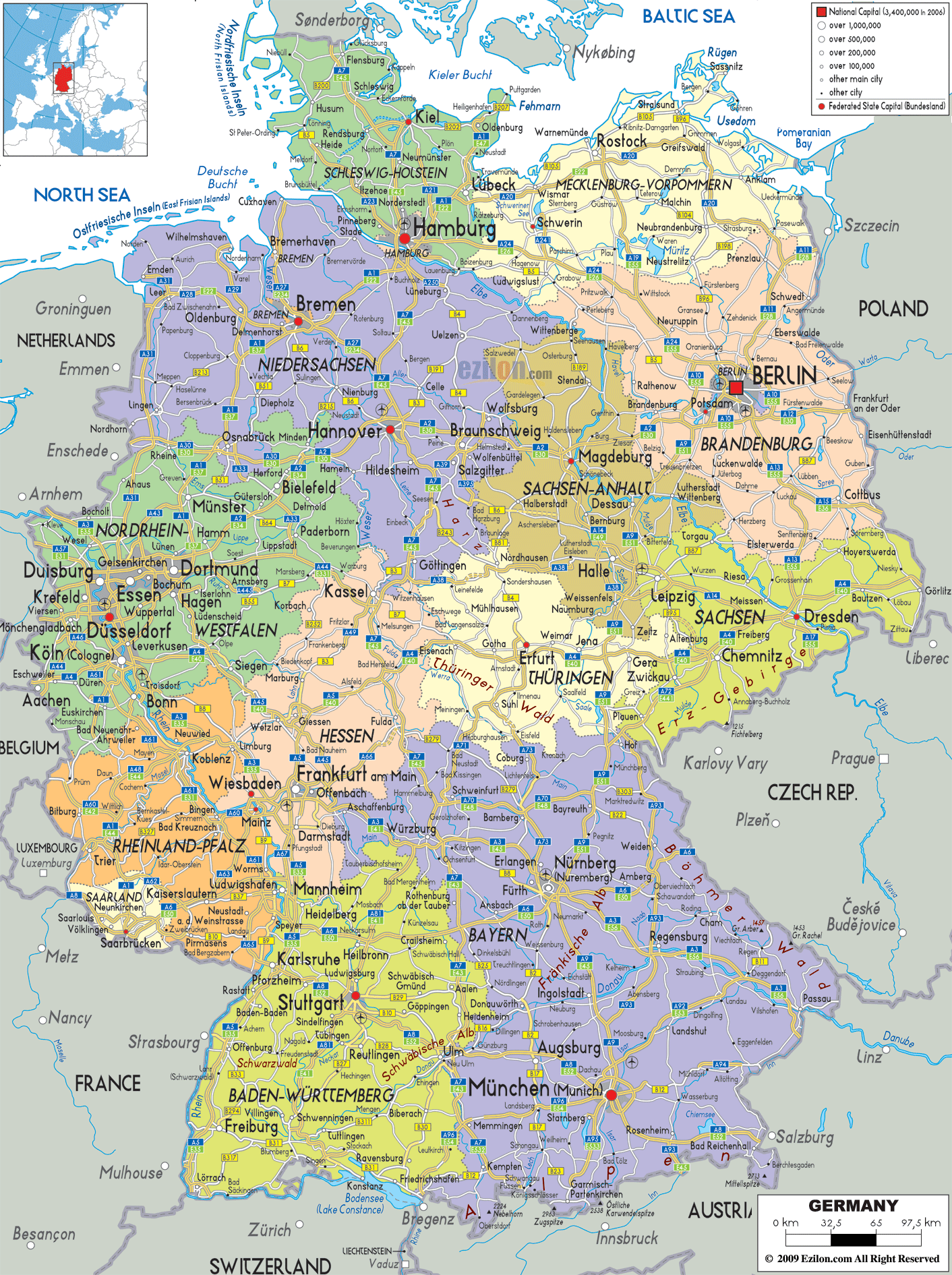
Description: Detailed large political map of Germany showing names of capital cities, towns, states, provinces and boundaries with neighbouring countries.
 The political map of Germany displays the state and city boundaries and other important boundaries that are connected. Germany sits at the center of Europe and this country's political map shows geographical position, historical as well as administrative importance, which is a feature in Europe.
The map of Germany is a practical map that portrays the sixteen federal states of Germany in distinctive colours. Each state is clearly marked and labelled with the capitals of the federal states. Major cities .
In addition, major transport networks are also indicated. Ultimately, the authors of maps were likely making an attempt to help one understand the working of modern-day Germany through their map.
This guide walks you through each federal state, explaining what you can see on the map while also supplementing historical and geographical knowledge. Whether you are a geography student who wants to know about the federation of Germany, a traveler having queries about your route through a culturally diverse country, or just a reader, this will take you through the cities and the borders.
Beginning in the north, the political map reveals Germany's coastal ties to the North Sea and the Baltic Sea. The states here have long maritime traditions and strong connections to Scandinavia and northern Europe.
Schleswig-Holstein sits at the northernmost tip of the country, sharing a border with Denmark.
The state is flanked by both the North Sea and the Baltic Sea, which is clearly illustrated on the map by the coastlines and small islands like Sylt and Fehmarn. Kiel, the capital city, rests on the eastern shore, well-known for the Kiel Canal and its annual sailing events. Lübeck, another important city in this state, reflects Hanseatic history with its brick Gothic architecture and port activities.
Moving slightly southward, you'll notice Hamburg, one of Germany's three city-states and its second-largest city. Though small in landmass, Hamburg is symbolically large on the map and in the nation's economy.
It is on the river Elbe, as well as one of Europe's busy ports. The city's big lettering on the map indicates its political and commercial importance.
To the east is Mecklenburg-Vorpommern, a state known for its tranquillity, national parks and historic spa towns.
According to the map, Rostock and Schwerin (the state's capital) are cities in the state. Schwerin is marked on the map with a yellow capital. The beautiful palace that sits in a lake there is famous.
Perhaps the most eye-catching element of the map is Berlin, the national capital, highlighted with a red square and bold letters. Berlin stands as its own federal state, surrounded completely by the state of Brandenburg. On the map, this unique arrangement is immediately visible—a city-state completely enclosed by another state.
Berlin's position near the northeastern border speaks volumes about its history, especially during the Cold War when it was a divided city. Today, it is a thriving hub of culture, politics, and innovation. While the map doesn't mark individual districts, one can visualize places like Mitte, Kreuzberg, and Charlottenburg forming the city's internal patchwork.
Surrounding Berlin is Brandenburg, a sprawling and largely rural state. The capital city of Potsdam lies just southwest of Berlin and is known for its palaces and parks. Also marked on the map are towns like Cottbus and Frankfurt (Oder), the latter positioned on the Oder River which forms the border with Poland.
Continuing east, the map guides us through the cultural and industrial centers of former East Germany.
Saxony-Anhalt is positioned just west of Brandenburg with cities like Magdeburg and Halle (Saale) marked on the map above. The state capital of Magdeburg is a former imperial city and modernization engineering and education. The city of Halle lies slightly to the south on the map. Halle is an academic center, cultural center, and centre of music and chemistry.
Further southeast, you enter Saxony (Sachsen), colored in light green on the map. This state borders the Czech Republic and is among Germany's cultural jewels. Dresden, its capital, sits along the Elbe River and is famed for its reconstructed historic center. Leipzig, to the northwest, is another major city marked clearly on the map and known for its musical heritage, economic revival, and vibrant arts scene. Chemnitz and Zwickau are also labeled, cities known for their role in automobile manufacturing and historical architecture.
Thuringia (Thüringen) sits at the center of Germany and acts as a natural connector between east and west. It is shown in cream on the map, with Erfurt as its capital - a city renowned for its medieval bridge and cathedral. Other important cities marked include Jena, a university city known for optics and engineering, and Weimar, historically important for its cultural and literary contributions.
The western part of the map reveals some of Germany's most densely populated and economically significant areas.
North Rhine-Westphalia (Nordrhein-Westfalen) is the country's most populous state, displayed in mint green. The map showcases an impressive array of cities: Düsseldorf (the capital), Cologne (Köln), Dortmund, Essen, Bonn, and Münster.
The cities of the Ruhr. Formerly dominated by coal and steel, the Ruhr has now become a modern centre for education, media and services. Map showing state's vibrant urban density marked by industrial corridors and railway lines.
To the south lies Hesse (Hessen), shown in orange. The state capital Wiesbaden and the financial capital Frankfurt am Main clearly show this. Frankfurt is located in the centre of Europe. The map of Frankfurt indicates that it has a lot of rails and roads. Also included are the towns Kassel and Offenbach, and the town of Darmstadt which all contribute to education, the arts, or technology.
Rhineland-Palatinate (Rheinland-Pfalz) is warm brown in colour, extending west towards France and Luxembourg. The capital city of Mainz is located on the Rhine and is famous for its wine and media. Several places like Trier, Koblenz, and Kaiserslautern seem to appear close to rivers and wooded areas. Thus, giving the state geographic depth, wine-growing and historic importance.
Saarland is one of Germany's smaller states situated between Rheinland-Pfalz and France and its capital city is Saarbrücken. The political map shows that we were very close to France and that hinting at a Franco-German culture and a coal-based industry.
In the south, the map showcases Germany's largest state: Bavaria (Bayern). With its borders touching the Czech Republic and Austria, Bavaria is colored in a soft violet, and cities like Munich (München), Nuremberg (Nürnberg), Augsburg, Regensburg, Ingolstadt, and Passau are vividly marked.
Munich, the capital, is a key economic and cultural center. The map's detail shows its location near the Alps, with connections to Austrian cities. Nuremberg, north of Munich, is a historic and industrial center, while Augsburg and Regensburg reflect Roman and medieval heritage. Each city on the map represents a blend of deep history and modern vitality.
Just to the west lies Baden-Württemberg, shown in bright yellow.
Stuttgart, the capital city of the country Germany has a huge automobile industry holding the fortune. You can spot it on the map clinching the cities of Karlsruhe, Freiburg, Mannheim, Heidelberg, Ulm, and Reutlingen. The Black Forest area is not distinctly marked on the map, but it occupies a significant part of the state's geography and can be inferred due to the clustering of cities and borders.
The political map shows the borders of Germany with nine neighbouring countries. That is essential for students and travellers. To the north is Denmark, connected via Schleswig-Holstein.
To the east, Germany touches Poland and the Czech Republic. Austria and Switzerland are to the south and France, Luxembourg, Belgium and the Netherlands are to the west. Germany is central to commercial, political and travel ties of Europe.
As you analyze the symbols on the map, you notice:
Red squares indicating the national capital (Berlin)
Yellow dots for state capitals
White circles for other major cities
Black dots for smaller towns
Blue line indicates Autobahn and thinner blue lines are rail connections. Cities like Frankfurt, Stuttgart and Berlin, appear as major transport nodes, as evident from the clustering of lines and their nearby urban areas.
For geography students, the map shows how political areas interact with economic areas, transport systems and historical areas. Students are introduced to the idea of federalism, city-states and distribution of population centres.
Travelers can use this map to plan their routes from one city to another. Going on a ‘journey’ from Hamburg to Munich, or from Cologne to Dresden, is more than just moving across space. It's travelling through culture, language, and countryside.
The map also highlights underappreciated cities that have played an important regional role:
Oldenburg in Lower Saxony, known for its academic institutions
Pforzheim, the “Gateway to the Black Forest” in Baden-Württemberg
Coburg and Bayreuth in Bavaria, centers for heritage and music
Görlitz, near the Polish border, with well-preserved medieval architecture
Plauen and Zwickau, important to Saxony’s industrial landscape
These cities enliven the political map and reflect that each dot and line corresponds to a vibrant space in it.
The political map of Germany is much more than a list of the name of the states or the location of cities. The rich history, present-day administration, diversity of culture, and logistical marvels of the country. The states on this map each tell a part of the national story. Each city is a paragraph of character and competency.
Whether studying, travelling, or just admiring geography, the map of Germany of this country introduces the readers to a united and diverse nation. From the coastal winds of Kiel to the mountain views of Munich, every region has its own and its own on this map.

Physical Map of Germany
Physical map and map image of Germany.

Road Map of Germany
Road map and map image of Germany.

Regional Directory of United States of America
Information and guide about United States of America and websites with American topics.

Regional Directory of Europe
Information and guide about Europe and websites with European topics.

Regional Directory of Australia
Information and guide about Australia and websites with Australian topics.