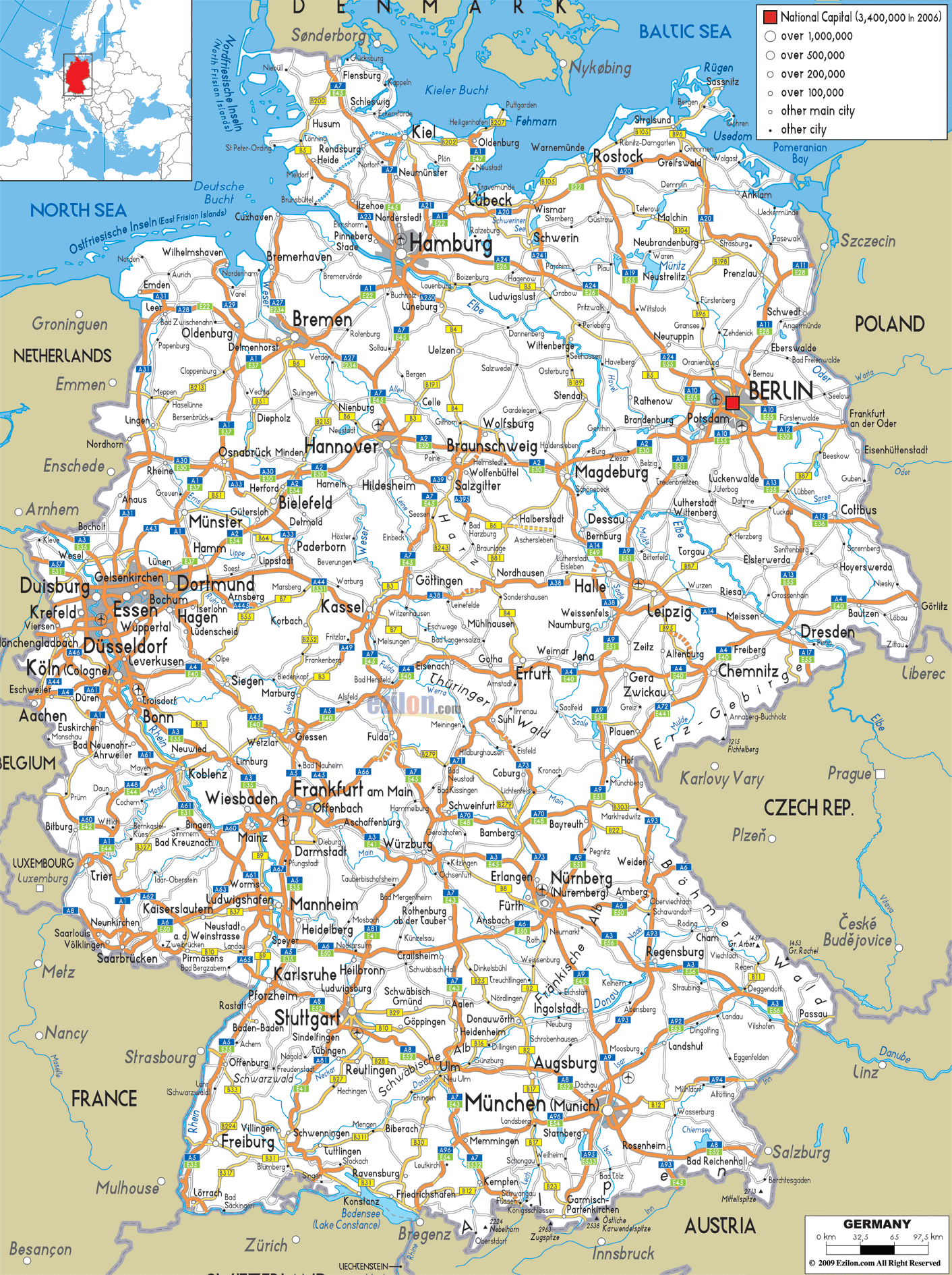
Description: Detailed clear large road map of Germany with road routes from cities to towns, road intersections in regions, provinces, prefectures, also with routes leading to neighboring countries.
 Detailed map of Germany with Road Map of Germany with Highways and Expressways connecting its cities and states with neighbouring Denmark, Poland, Czech Republic, Austria, Switzerland, France, Luxembourg, Belgium and Netherlands. When you examine this comprehensive road map of Germany, you're looking at one of the world's most sophisticated and interconnected transportation networks.
This map shows a detailed overview of the highways, federal roads, and other roads in Germany's 16 Federal States with a population of more than 80 million. The map shows routes that helped Germany become Europe's economic power. It also shows the roads in Germany.
If you look at this road map, you will notice different types of roads in different colours and numbers. The thick orange lines criss-crossing the country represent the Autobahn network of the country of Germany.
It is the famous highway network of Germany which has no general speed limit. These start with A followed by either single, double or triple digits. The Bundesstraßen (federal roads) appear as thinner yellow lines, marked with "B" numbers, serving as the backbone for regional connectivity between major cities and rural areas.
The map's legend clearly indicates population centers, with Berlin marked as the national capital (3,400,000 to 2006), while cities are categorized by population: over 1,000,000, over 500,000, over 200,000, over 100,000, and other main cities. This classification system helps you understand the hierarchy of urban centers and their corresponding transportation infrastructure needs.
In Germany's northernmost state, you can trace how the road network adapts to the unique geography of the Jutland Peninsula. Highway A7 serves as the main north-south artery, connecting the Danish border at Flensburg through Schleswig, Rendsburg, and continuing south toward Hamburg. This important German highway provides a vital transit route for the inland traffic between Scandinavia and Europe.
The A1 creates an east-west connection across the state, linking Lübeck on the Baltic coast with the North Sea regions. At Kiel, the state capital, you can see how three freeways overlap: A210 offers direct access to the Baltic Sea port, A215 runs south to the A7. The road network in this area has to deal with not just normal traffic but also the heavy ferry links to Scandinavia – an important transport hub who is Kiel.
Lübeck, the former Hanseatic League capital, sits at the intersection of the A1 and A20, with the latter forming part of the Baltic Sea coastal highway that extends eastward toward Rostock. The A20 is a new highway in Germany, designed to improve connections along the Baltic coast and relieve pressure on ageing routes.
Hamburg, Germany's second-largest city, appears on the map as a major transportation nexus where multiple highway systems converge. The A1 approaches from the northeast (from Lübeck) and southwest (toward Bremen), while the A7 provides the crucial north-south connection from Schleswig-Holstein toward Hannover and beyond.
The A23 extends northwest from Hamburg toward the North Sea coast and the resort island of Sylt, handling significant tourist traffic during summer months. The A24 heads east toward Berlin, representing one of the most important connections between northern and eastern Germany. The A25 forms a southern bypass around Hamburg, connecting with the A1 to manage traffic flow around the metropolitan area.
In the Hamburg region, you can see how the road network deals with the geography of the city. The Elbe River creates a natural obstacle to which the highways have to connect. The Elbtunnel and the different bridges carry the major routes across the river. So, all routes lead to Hamburg's port, Germany's second-largest one.
Lower Saxony (Niedersachsen) presents a fascinating study in how road networks serve both urban centers and vast agricultural regions. Hannover, the state capital, sits at the intersection of major north-south and east-west routes. The A2 runs east-west through Hannover, connecting the Ruhr region with Berlin - one of Germany's most heavily trafficked routes. The A7 connects the city north-south, and the A37 provides the eastern bypass round the city.
Bremen, though technically a separate city-state, integrates seamlessly into Lower Saxony's road network. The A1 connects Bremen with Hamburg to the northeast and the Ruhr region to the south. The A27 provides a direct north-south route through Bremen, connecting to the coastal regions and continuing south toward the A1.
The road network in Lower Saxony must serve diverse needs: connecting major industrial centers like Wolfsburg (Volkswagen's headquarters) via the A39, serving agricultural regions with efficient federal road connections, and handling significant east-west transit traffic between western Europe and Berlin/eastern Europe.
The road network in Germany's northeastern state is indicative of the coastal area's characteristics and the connection between Germany and Poland and the Baltic states. The biggest city, Rostock, is linked to the road and motorway network by the A19 south toward Berlin. The A20 provides the crucial east-west coastal connection, linking Rostock with Lübeck to the west and continuing eastward toward the Polish border.
Schwerin, the state capital, sits at the intersection of the A24 (Berlin-Hamburg route) and A14, which provides connections southward. The road network here must accommodate significant seasonal variations, with summer tourist traffic to Baltic Sea resorts creating different demands than the year-round agricultural and industrial transportation needs.
Berlin, which you will notice on the map to Germany’s capital and largest city that is all quite a complicated network of highways. Berlin is of course the political and cultural center of Germany. The A10 forms the Berliner Ring, a circular highway that encircles the metropolitan area and serves as a distribution point for traffic heading to different parts of the city and surrounding Brandenburg state.
Multiple highways radiate outward from Berlin like spokes of a wheel: the A2 heads west toward Hannover and the Ruhr region, the A9 runs southwest toward Munich, the A13 connects southeast toward Dresden, and the A11 provides connections northward toward the Baltic coast. The A24 links Berlin with Hamburg, while the A12 heads east toward the Polish border at Frankfurt an der Oder.
The road system surrounding Berlin embodies the challenges posed by German reunification. After 1990, a lot of the connections would have to be reconstructed or significantly upgraded to handle the increased traffic. The A10 ring road has significantly further mitigated traffic congestion in the city centre in particular.
Saxony (Sachsen) showcases how road networks serve both traditional industrial regions and modern economic development. Dresden, the state capital, sits at the intersection of the A4 (east-west route connecting western Germany with Poland) and the A13 (connecting Berlin with the Czech Republic via Prague).
Leipzig is the largest city of Saxony. It is a major Transportsation centre. The A9 runs from Berlin to Munich and merges with the A14 (which connects central Germany with the A9) and the A38 (a more east-west route through central Germany). Leipzig is an important logistics location for eastern Germany because of this intersection.
The A4 is Saxony's principal route towards the east-west, linking Dresden to Chemnitz, and continuing west towards Erfurt and Frankfurt am Main. This route has a lot of international movement to and from Germany and Eastern Europe, notably the Czech Republic and Poland.
Saxony-Anhalt (Sachsen-Anhalt) occupies a strategic position in central Germany, with its road network serving as a bridge between northern and southern regions. Magdeburg, the state capital, occupies the A2 (the principal east-west link across northern Germany) and connects to the north through the A14 to the A2’s junction with other routes.
Halle, the largest city in the state, marks another important intersection where the A9 (Berlin-Munich route) meets the A14 and joins the A38 east-west route. Halle-Leipzig, Germany’s most important logistics region is in this position.
The state of Thuringia (Thüringen), which is often called the “Green Heart of Germany” is a clear indication of this. More specifically, how road networks are adapted to mountainous terrain while still maintaining an efficient connection. The state capital Erfurt is located at the crossroads of the A4, which runs east and west, and the A71, which is a north and south connection to Bavaria.
The A4 is the principal road to Thuringia. It connects the area to western Germany (and Frankfurt am Main) as well as eastern areas (Dresden). The northern part of the state and Saxony-Anhalt and Lower Saxony can be accessed through the A38.
North Rhine-Westphalia (Nordrhein-Westfalen) contains Germany's most complex and heavily trafficked road network, serving the country's largest population concentration and most important industrial region. The Ruhr Area, encompassing cities like Dortmund, Essen, Duisburg, and Bochum, represents one of Europe's largest urban agglomerations and requires an extraordinarily sophisticated transportation network.
In Cologne (Köln) converge more highways any other place in the world. The A1 connects the north and the south. The A3 moves southeast towards Frankfurt. The A4 heads eastwards towards central Germany. The A57 runs northwards and into the Ruhr region. The system of motorways that includes the A1, A3, and A4, as well as various connecting roads, encircles this substantial city.
Düsseldorf, the state capital, is connected to this network by means of the A3, A44, A46 and A52, the last one with the Rhine – Ruhr metropolitan region. The A57 runs north-south across the west of the state and links Cologne with the Netherlands.
The Ruhr area itself has a network of highways that could have served multi major cities in a close range. The eastern and western regions of A1 are connected by A2. Furthermore, the eastern end of A2 connects to Berlin after Dortmund. The A40 runs east and west through the centre of the Ruhr and links roads A42 and A43 with other roads in the complex.
It is connected to the network by means of the A1 and the A43. It represents an essential regional centre of importance in North Rhine -Westphalia. In this area, the road network must strike a balance between meeting a local urban demand and catering to a significant amount of international transit traffic. This traffic connects the Netherlands and Belgium with the rest of Germany.
Rhineland-Palatinate (Rheinland-Pfalz) demonstrates how road networks adapt to river valley geography while serving important economic functions. Mainz, the state capital, sits at the confluence of the Rhine and Main rivers, where the A60 and A63 provide connections within the Rhine valley system.
The A3 is the main North South connection through the state. It goes via the Rhine valley and on to Frankfurt am Main and Cologne. Connecting with the A1 nearby the Luxembourg border, the A61 offers alternative route through the state's western part in the north-south direction.
The A48 connecting to the A1 westward meets the A61 north-south at the junction Koblenz. Because the Rhine and Moselle rivers come together in this city, road networks follow the river valleys. In effect, this has always been a transportation hub.
Hesse (Hessen) is located in the middle of the road network in Germany. Frankfurt am Main is one of Europe's most important transport hubs. The A3 runs north-south through Frankfurt, linking it with Cologne, Würzburg and on into Bavaria. The A5 is another important north-south route through the Netherlands and northern Germany to Switzerland and southern Europe.
The A3, A5, A66 and A661 converge at the most complicated motorway junction anywhere in Germany; in Frankfurt am Main. To the West of the Frankfurt Ring system is where traffic steering takes this metropolitan area, which are not only the city but also the main airport of Germany and the main financial centre of Germany.
The state capital Wiesbaden is connected by the A66 to Frankfurt and the autobahn system. Kassel is located in northern Hesse at the intersection of the A7 (major north-south route) and A44 (east-west connection). It is a major regional hub.
The A4 traverses eastern Hesse and creates links with Thuringia. With the north-south A7, a grid pattern is created in this area for the smooth flow of traffic in the state.
Baden-Württemberg showcases how road networks serve both high-tech industrial regions and provide access to Alpine recreation areas. Stuttgart, the state capital, sits at the intersection of multiple major highways: the A8 (east-west route toward Munich), the A81 (north-south connection toward Switzerland), and the A6 (connecting toward Heilbronn and northern regions).
The A5 is the state's main north-south route and runs through the Rhine valley from the Swiss border near Basel through Freiburg Karlsruhe and northwards to Frankfurt. A lot of international traffic goes through this route between Switzerland, southern Germany, and northern Europe.
Mannheim represents a major intersection point where the A5 meets the A6 (east-west route toward Nuremberg) and the A61 (connecting northward toward the Rhineland). The A656 provides connections within the Rhine-Neckar metropolitan region, which includes Mannheim, Heidelberg, and surrounding areas.
The A5 heads through Karlsruhe, and the A8 branches away to the east, heading for Stuttgart and Munich. This road network must be suitably designed for regional traffic in our own territory in Baden-Württemberg and international transit traffic from France and Switzerland to Germany and vice versa.
Munich is the capital city of Bavaria, and it is the third largest city in Germany. The A8 runs east-west through Munich and connects Stuttgart with Salzburg in Austria. The A9 motorway links the north and south and connects Munich with Berlin. A95 heads south to the Alps and Garmisch-Partenkirchen.
Munich Ring (Münchener Ring) traffic is diverted along the A99 that circumscribes the Munich metropolitan area. This ring road interconnects with all the major highways serving the area with traffic flow around one of the most economically significant cities in Germany.
Another major centre is Nuremberg (Nürnberg) where the A3 (Frankfurt – Czech Republic) connects with the A6 (east – west) and the A9 (Munich – Berlin). Nuremberg's intersection makes the city a vital logistics node for domestic and international traffic.
The A7 runs through western Bavaria north-south. It joins Würzburg to the Austrian border, near Füssen. This road, romantic road, that traverses tourist regions, gets to the popular alpine region.
Augsburg is located on the A8 between Munich and Stuttgart which makes it a regional centre. Augsburg has high heavy goods traffic due to industrial traffic to and from the large manufacturers of both Augsburg and Munich and to the tourism traffic to the Alps.
Germany's northern road network is an important connection to Denmark and, through a ferry service, farther into Scandinavia. The A7 runs all the way to Flensburg at the Danish border, with international traffic. The E45 European route also follows along this corridor, indicating its significance.
Ferry services between ports such as Kiel, Lübeck and Rostock create further international connections that must be serviced by the road network. The A20 that runs along the Baltic sea coast has been especially built to improve connections to these ferry terminals and relief urban traffic.
The highway network has at least six important crossing points at Germany's eastern border with Poland. A4 schnellstraße Dresden – Prague (local/foreign trade) The A4 connects Dresden with the Czech Republic via Prague. It carries a significant volume of commercial traffic. The route also sees considerable tourist traffic. The link from Berlin to the capital of the Czech Republic is provided via the A13. The A12 links Berlin with Poland Frankfurt an der Oder.
These eastern connections have become increasingly important since EU expansion, with Germany serving as a transit country for goods and people moving between Western Europe and the new EU member states in Central and Eastern Europe.
The highways through the Netherlands, Belgium, Luxembourg and France along Germany's western borders are among the busiest international highways in Europe. The A3 links to the Dutch motorways just before the border. The A40 and other routes into the Ruhr are very busy with traffic to and from Holland.
The A1 links to Belgium and Luxembourg while the A6 links to the French highways in the Saarland area. Germany boasts extensive connections with a delay of site-specific networks to and through the federal territory and a high-priority European freight transport network.
Germany's southern frontier boasts highway links to Austria and Switzerland that negotiate tough Alpine terrain. The A8 runs to Austria toward Salzburg A95 to the Alps with connections to the Austrian highways
The A5 road near Basel leads to the Swiss border and is a main north-south European route. The traffic at these Alpine links is varied can be traced from seasonal to seasonal, whereby the peak periods are created predominantly from the winter sports tourism and summer recreation.
Germany's economic growth has been shaped by industrial corridors that the road map showcases. Spread across a 50,000-square-kilometre area, the Rhine-Ruhr corridor is home to more than 10 million people. The region around Frankfurt, known as the Rhine-Main corridor, is Germany's financial centre, logistics centre.
The Munich-Nuremberg corridor along the A9 represents Bavaria's economic backbone, while the The corridor of Stuttgart Mannheim serves the cutting-edge industries of Baden-Württemberg. The corridors illustrate that transport infrastructure strengthens economic development and vice versa.
Germany's highway network also serves major tourism flows. The Romantic Street in Bavaria is mainly served by federal roads, but connects to the highway network at various points. The various alpine tourism roads in Bavaria and Baden-Württemberg are designed for seasonal traffic to be accommodated by the road system.
Tourism at the Baltic Sea creates summer traffic peaks on the A20 and A1 in Mecklenburg-Vorpommern and Schleswig-Holstein. Design of the road network is based on the seasonal applicability, demand of permanent residents and seasonal visitors.
Germany's road network faces ongoing challenges related to infrastructure aging, increasing traffic volumes, and changing transportation patterns. Many highway sections built in the 1960s and 1970s require major reconstruction, while eastern German routes continue to be upgraded to western standards.
The integration of electric vehicle charging infrastructure, smart traffic management systems, and autonomous vehicle technology will require significant modifications to existing highway infrastructure. The expansion of e-commerce means freight patterns are changing, so the road network must adapt.
New hurdles for the development of the road network due to Germany's environmental protection. To maintain our wildlife crossing structures, reduce noise pollution, and improve air quality, we need money to amend the current structures.
There may be a realignment of traffic flows on our highway network as we move towards more sustainable transport modes like greater rail freight and public transport. The road system will still be significant for regional connections and final mile freight delivery.
This detailed map for Germany shows a transportation network that has been systematically built, rebuilt, and integrated over a period of more than 70 years. Germany's Autobahn System: An overview of its origins and evolution from the original concepts presented in the 1930s to post-war reconstruction, reunification challenges, and modern European integration
The network has multiple functions that connect Germany's regions to one another as well as the world. They also help develop the economy and access activities. The planned interconnection of highways, federal roads and regional links provides a network for the transportation of local and long distances.
This map shows how transportation infrastructure shows and shapes economic and social development. Industrial areas such as the Ruhr and areas radially developed around the large cities including Berlin and Munich as well as cross-border developments along all frontiers show how road networks create the framework of modern economic life.
Germany's needs for its roadways will only grow into the future. Given new technologies, new requirements from the environment and new transportation patterns, its roadway musts will steadily evolve. That said, the roadway is already the backbone of Europe's largest economy and most populous country. Investment in this facility is more than just a transport policy, it is an economic unification and a social lift that are international commitments extending beyond Germany.

Physical Map of Germany
Physical map and map image of Germany.

Political Map of Germany
Political map and map image of Germany.

Regional Directory of United States of America
Information and guide about United States of America and websites with American topics.

Regional Directory of Europe
Information and guide about Europe and websites with European topics.

Regional Directory of Australia
Information and guide about Australia and websites with Australian topics.